COMMUNITY NATURAL RESOURCE MANANGMENT PLAN (CNRMP)
Anchengbok Village
Rongjeng C&RD Block, East Garo Hills
MEGHALAYA BASIN MANANGEMENT AGENCY
District Project Management Unit
Williamnagar, East Garo Hills District
August, 2021

The CONTENT
The Anchengbok Village
The Village Resources
The Social Resources
The Natural Resources
Type of forest Cover and Wildlife
Cultivable Land
Water Bodies
Spring Inventory
Problem Analysis
Community NRM Plan with Estimates
Brief Justifications on Proposed activities
Community Nursery
Composting
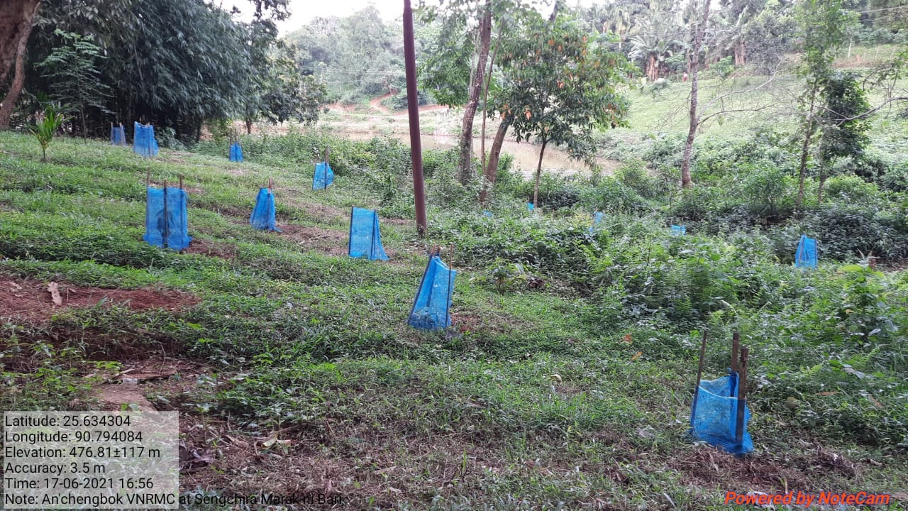
Plantation/Afforestation/Reforestation
Spring-shed Development and Management
Check Dams
Forest Management Plan
Gabion Wall/Gully Plug
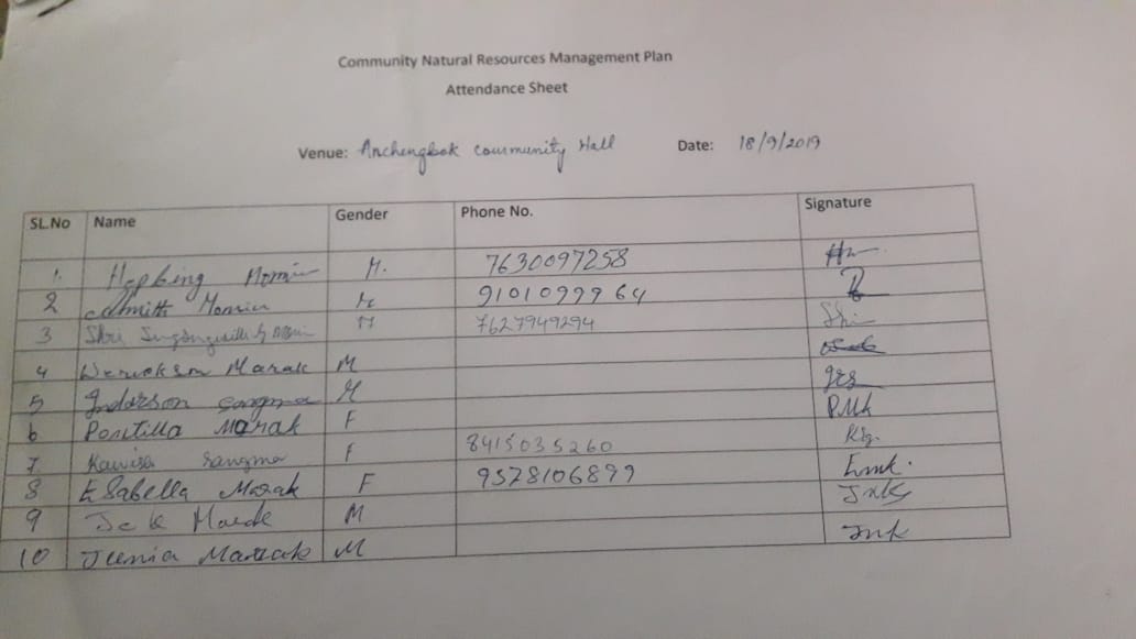
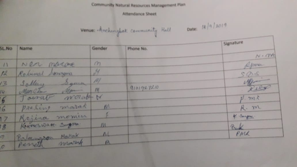
Annexure - 1
Attendance Sheet
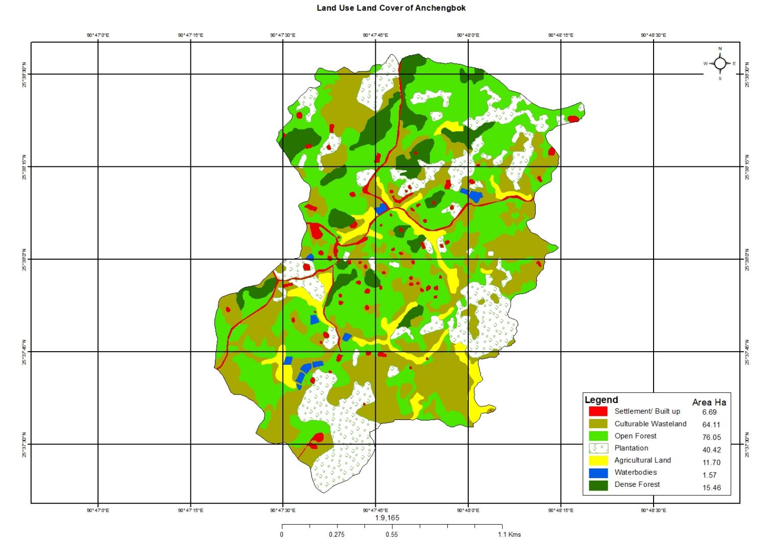
LULC Map
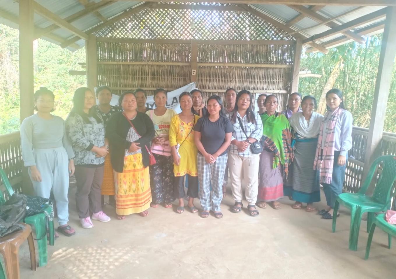
Photo Gallery
Anchengbok Village
The Anchengbok village falls under Rongjeng C&RD Block of East Garo Hills district in Meghalaya. The village is inhabited by Garo Community with 69 households and 399 populations out of which 212 are females and 184 are males. The VNRMC in this village was formed on 8th November 2019. The village is located 21.2 KM away from Rongjeng Block and 65 KM from the district headquarter, Williamnagar. The Land Use Land Cover (LULC) map of this village identified the GPS co-ordinates- 25.633023 and 90.793231 for latitude and longitude respectively. The village elevation reading is 571.35 msl (Annexure-1).
The Village Resources
The Social Resources
The land ownership of this village is owned by the Headman which is called ‘Nokma A’King1 land. The main institution in the village is the Nokma, the Village Employment Council (VEC) and 6 Self Help Groups. There is no ‘Water and Sanitation Committee’ in the village, which the CLLM-Project needs to promote. The Nokma institution consists of 4 members- the Nokma, Sordar, President and a Secretary. More than half of the total households use firewood as the main source of fuel and only about 15 HH use LPG. The village has a good electricity connectivity with 47 households being electrified. Most of the population is also farmers depending on Jhum Cultivation.
The Natural Resources
Through GIS technology the project has collected data which shows that Anchengbok VNRMC has a total of 216 Ha of geographical area of which, the total forest cover area is 91.51 Ha. Water bodies coverage is 1.57 Ha. The village has Agricultural land measuring of 11.70 Ha and 64.11 Ha of culturable wasteland. Arecanut plantation is the major cash crop in this village.
Type of Forest Cover and Wildlife in Anchengbok Village
The LULC provided that total forest land in this VNRMC is 91.51 Ha which comprises of dense forest as well as open forest. There is community forest reserved for conserving the flora and fauna of the village. The villagers are not allowed to cut trees or practice jhum cultivation on this reserve land. The indigenous species of trees found in this village are Sal (Shorea-robusta), Boldak (Schima wallichii) ,Dimbil (Fig tree), Kimde (Ironwood), Agol, Jackfuit, Tebret, Bolkasin (Xylia xylocarpa), Neem, Mau, Gasampe, Litchi , Nosing (Curry Leaves), Chambu (Black Plum), Agimik, and Terimu (Sal Tree Maximum). During the VNRM Plan preparation, the villagers have agreed to improve this community open forest. In addition to this, fodder species used by the villagers for feeding the cattle are Nengitchak, thysanolaena spp., Dakdak. There are also NTFPs in the forest like Bamboo, Calamus and floribundus and herbs. Due to reduction in forest cover and unavailability of food, the existing fauna such as Deer, Monkey, Squirrel, jungle fowl are in danger and decreasing in population.
Cultivable Land
The village has 11.70 Ha of agricultural and 40.42 Ha of land is covered by plantation which is mostly arecanut. The land is becoming less productive due to unavailability of irrigation facilities, soil erosion and deforestation.
Water Bodies
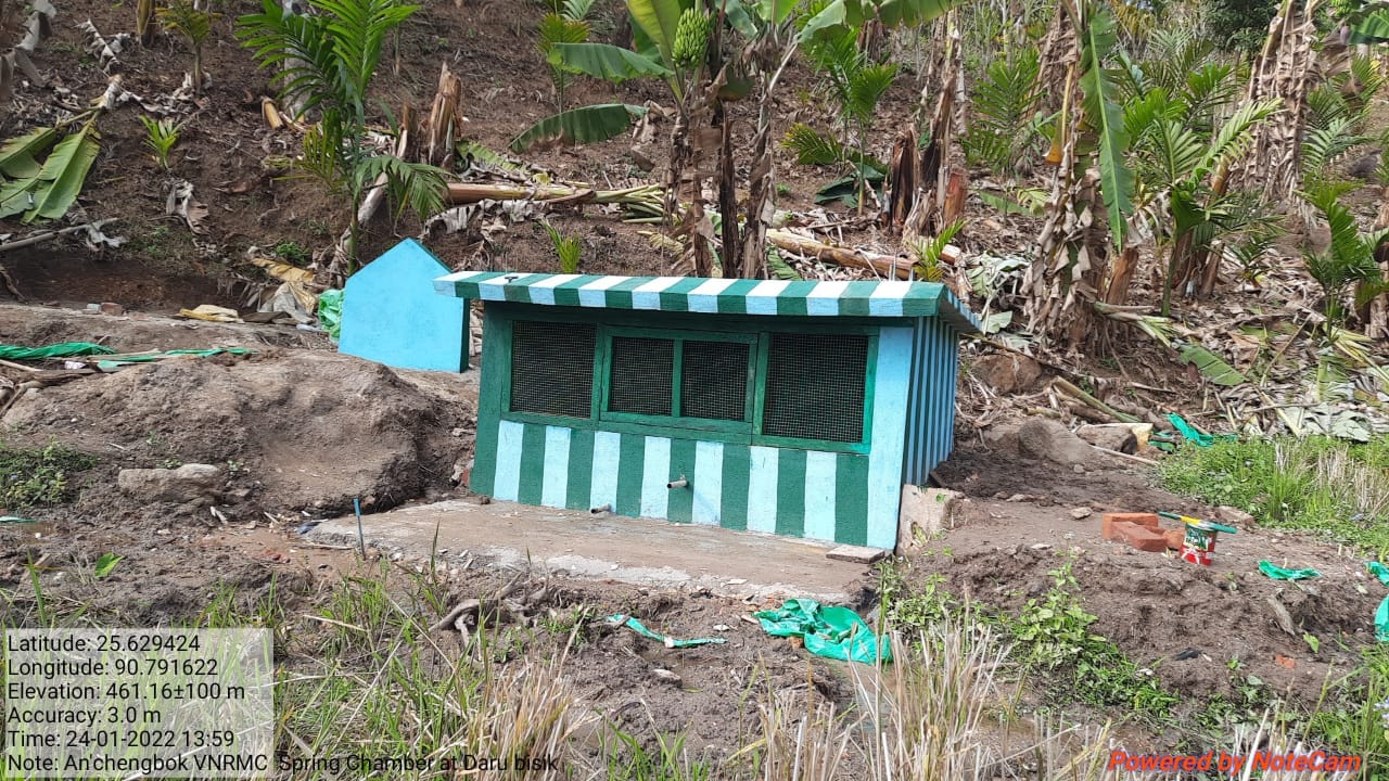
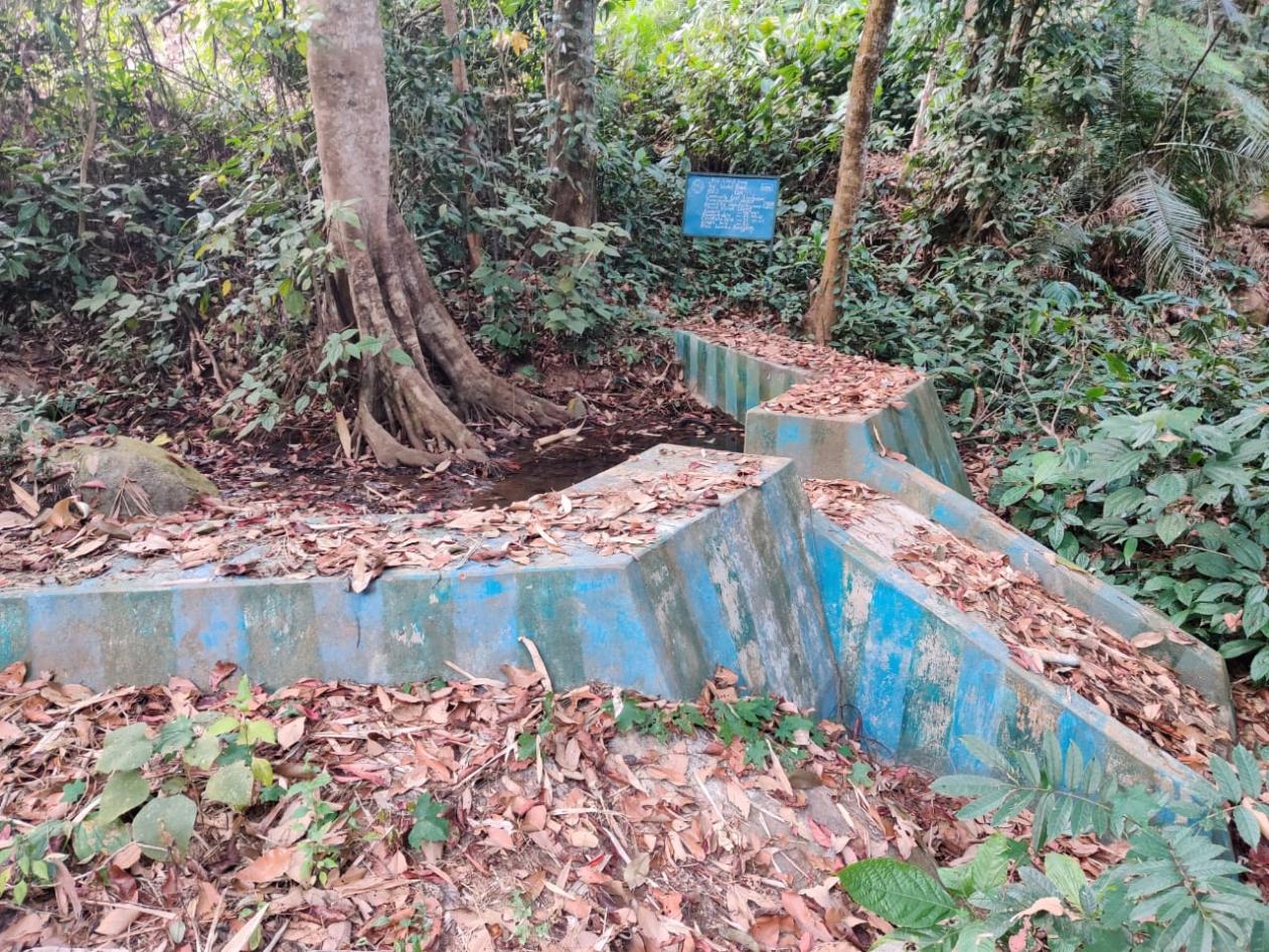
The village has 5 springs namely Nengtuju Spring, Daru Bisik, Nengdrong Bisik, Anchengbok Bipek and Anchengbok Bisik. All these springs are perennial, however, during the lean season, the water discharge reduces to large extend. Only one spring has been tested out of these water bodies as on date for intervention. These water bodies are used for domestic, irrigation and other purposes. Water crisis occur during the months of February, March, and April. To tackle water shortage from springs, spring chambers were built in Nengtuju spring and Daru spring funded by CLLM-Project. These spring chambers have been very helpful to 20 households.
Spring Inventory
The Master Trainers have (VCFs) taken the discharge measurement of Anchengbok spring (latitude of 25.636764°N and longitude of 90.796168 °E with elevation of 521.63 M). It is a depression spring and perennial in nature. The spring water is used for drinking and for domestic purposes. Spring discharge was calculated 3.2 LPM through stopwatch- bucket method. The pH value of the spring is 6.63 LPM. The catchment area of spring is in the private land. Broad geology in and around the spring location is of weathered rock. Not only this, the VCFs measure all the springs every month and submit the data to Asst. Manager (Environment Management) for spring mapping.
Problem Analysis
The above village resource data collected through GIS technology, primary data collection made through CNRMP template and Spring Inventory templates suggests that the village is still rich in natural resources. At the same time natural resource degradation has started in this village that needs planned actions and interventions. The area of open forest is increasing and dense forest decreasing in the village. This is due to slash and burn cultivation, cutting down of trees for timber, firewood and for plantation for immediate economic benefit. These have resulted in less water discharge of water from springs, streams and rivers which has brought about low moisture content in the ground, loss of soil fertility and deterioration in land productivity. The flora and fauna in the village are also reducing drastically.
Community Natural Resource Management Plan with estimation
Having understood the natural resources of Anchengbok and having foreseen the upcoming threats to land, water and forest, the Villagers and VEC members of the village came together on the 8th Nov 2019 to form the VNRMC In order to identify and plan out interventions to address challenges faced in their village both in terms of NRM issues and their economic issues. The VEC with facilitation from DPMU-EGH and SPMU proposed a list of activities to be taken up in next three years’ time within the budget provision. The villagers strongly feel that these interventions would enable them to conserve and improve the natural resources for their future generations.
Proposed Activities Table-1
| Sl no | Proposed activities | Site Name | Benefitted area (Ha) | No. of HH benefit | Estimated Amt. (INR) | Date of work order issue | Date of work started | Date of work completion | |||
|---|---|---|---|---|---|---|---|---|---|---|---|
| CC Check Dam | Rongrure Stream | 4.5 | 24 | 270000 | 05-Feb-20 | 12-Mar-20 | 28-Mar-20 | ||||
| Afforestation | LP School Compound | 13.55 | 72 | 180000 | 09-Jun-20 | 14-Jul-20 | 13-Aug-20 | ||||
| Community Nursery | Chimikgre Reserve | 4.12 | 72 | 108840 | 09-Jun-20 | 08-Jun-20 | 22-Aug-20 | ||||
| Spring Chamber | Nengtuju Spring | 2 | 10 | 143800 | 25-Jan-21 | 08-Feb-21 | 27-Feb-21 | ||||
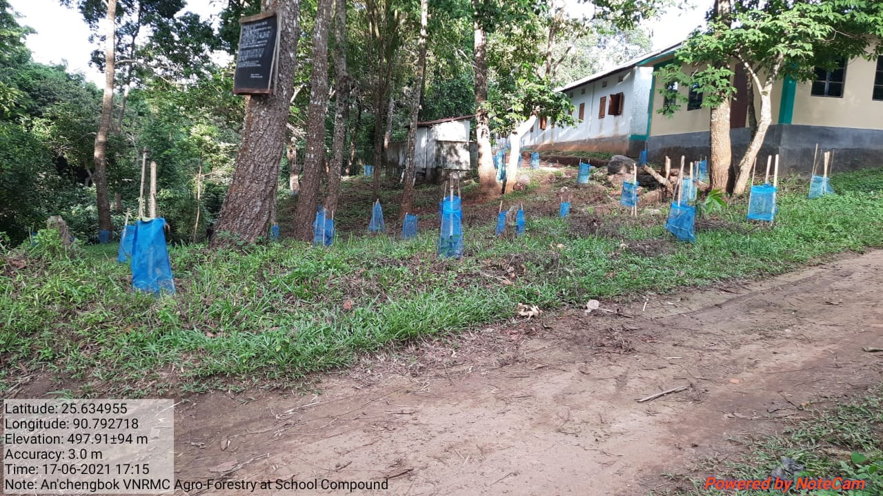
| Agro-Forestry | LP School Compound | 12.34 | 72 | 192400 | 02-Jun-21 | 08-Jun-21 | 16-Jun-21 | ||||
| RCC Check Dam | Nengtuju Bipek Stream | 9 | 11 | 259800 | 08-Jul-21 | 19-Jul-21 | 21-Aug-21 | ||||
| Dug Out Pond | Abobil | 8.95 | 72 | 90300 | 05-Oct-21 | 15-Oct-21 | 24-Oct-21 | ||||
| Dug Out Pond | Nengtuju Bisik | 8.96 | 72 | 83900 | 05-Oct-21 | 07-Oct-21 | 20-Oct-21 | ||||
| Hot Composting | Church Compound | 12.3 | 72 | 32800 | 03-Dec-21 | 10-Dec-21 | 27-Dec-21 | ||||
| Spring Chamber | Daru Bisik | 2.5 | 10 | 160300 | 03-Dec-21 | 16-Dec-21 | 20-Dec-21 | ||||
| Erosion Control Gabion Wall | Songmong | 15 | 72 | 147000 | 05-May-22 | 07-Jun-22 | 27-Jun-22 | ||||
| Lemon Plantation (Horticulture) | Lucas Marak'S Land | 9.8 | 72 | 86400 | 05-May-22 | 26-May-22 | 26-May-22 | ||||
| Water Storage Tank | Rongrure | 2.5 | 50 | 169000 | 05-May-22 | 19-Sep-22 | 21-Oct-22 | ||||
| RCC Check Dam | Chimikgre | 5.6 | 16 | 230460 | 05-May-22 | 04-Jul-22 | 26-Jul-22 | ||||
| RCC Check Dam | Anchengbok Bipek | 4.5 | 10 | 144200 | 17-Jun-22 | 26-Sep-22 | 25-Oct-22 | ||||
| Open Well (2 nos) | Abobil | 2.5 | 16 | 112500 | 17-Jun-22 | 03-Oct-22 | 22-Oct-22 | ||||
| Water Storage Tank | Chimikgre | 3 | 11 | 243300 | 17-Jun-22 | 21-Sep-22 | 26-Oct-22 | ||||
| TOTAL | 121.12 | 734 | 2655000 | ||||||||
Brief Justification on the Proposed Activities
Community Nursery
The details of the Community Nursery can be seen in table 1. The proposed nursery is meant for raising the saplings which will be planted in the open forest, catchment areas, reserve forest and private and covering to a total of around 91.51 ha of land. The roads connected to the village are far to the market, so sourcing building would pose as a challenge for the villagers, but since natural resources like water, trees, bamboo, etc. are readily available to them, they can quite easily construct an environment friendly nursery.
Composting
The villagers have also proposed to improve land productivity of agricultural land using composting so that the soil will be more fertile and that healthy plants in return would fetch more productivity leading to increased income.
Plantation/Afforestation/Reforestation
In this village there are only open forest in the village which is about 76.05 Ha. Villagers have realized that open forests are increasing which led to climate change and loss of biodiversity is increasing day by day. The villagers have decided to carry out Afforestation or reforestation & Agro-forestry both in the open forests as well as in the private. The committee members encouraged the villagers to plant fruit bearing and water retaining trees while carrying out reforestation for the benefits of all fauna and human beings alike. It will also restore and maintain balance in biodiversity.
Spring-shed Development and management
There are 5 nos of springs in the village which are perennial. The water discharge from these springs reduces drastically during the lean season. Development of spring-shed approach in this village along with rejuvenation activities such as afforestation, contour and staggered trenches in the catchment areas benefitting to about N/A ha of land that would help in increasing the discharge both peak and lean season catering to 75 households and reduced drudgery, especially of women.
Check Dam
Since there are unavailability of irrigation facilities during the month of February to April and the land become less productive, villagers have proposed 4 nos of check dam to be constructed for irrigation and domestic purpose of around 12 households will be benefiting from it. It is expected that 0.25 ha of land will be benefiting from this structures. Availability of water throughout the season can help the villagers to practice multiple cropping and follow crop rotation throughout the year which will increase the production and their income as well.
Forest Management Plan
The village has a Reserve forest which has been preserved by the community but due to extraction of timber by the villager themselves now it is consider as open forest. After the villagers realized that open forests were increasing which leads to climate change and loss biodiversity is increasing day by day. They wanted to reclaim the forest which is around 4ha to be brought under forest management plan which further increase its forest cover, take more preventive measures, etc.
Gabion Wall/Gully plug
The village has constructed a Gabion wall at Songmong in order to control land sliding on road sides and also to prevent the water logging area from further destruction. This has prevent blockage of road ,soil erosion etc.
Annexure – 1
Attendance Sheet
LULC MAP
The land belongs to a clan which is called Nokma A’king land. It is under the custody of its female head, the Nokma, whose husband acts on her behalf in all clan decision-making; the Nokma has no authority to take decisions on land and its use. Decisions are meant to be collective among representatives of the clan.↩︎
