 Village Profile
on
Village Profile
on
Lyngdoh Maram Village under Mairang C&RD Block
District: Eastern West Khasi Hills District
9th November, 2021.
COMMUNITY LED LANDSCAPE MANAGEMENT
PROJECT
(CLLMP)

The Government of Meghalaya with financial help from the world Bank is implementing the Meghalaya Community Led Landscape Management Project (MCLLMP). The Project will cover the entire State of Meghalaya and implementation of community led plans will be rolled out in phase manner throughout the state. The Meghalaya Basin Management Agency will facilitate community led planning by providing support, technical inputs, and funding.
The project is intended to strengthen community led natural resources management in selected landscape within the 11 Districts of the state. This would be achieved through a variety of planning, capacity building, and on- the ground interventions to promote the conservation sustainable use of natural resources, social inclusion, and community mobilization, building traditional knowledge and learning, mapping of natural resources management, strengthening the community institutions and creating linkage with financial institutions and community organizations.
The project interventions will include preparation of community led natural resource management plans. The CLLMP has the following three components:
Strengthening Knowledge and Capacity of communities for Natural resource management
Community Led- Landscape Planning and Implementation
Project Management and Governance
Objective:
 The project objective is
“to manage and conserve the natural resources, especially
forests, soil and water sources, in a manner that supports the
financial and physical well- being of communities in the
State.”
The project objective is
“to manage and conserve the natural resources, especially
forests, soil and water sources, in a manner that supports the
financial and physical well- being of communities in the
State.”
The CLLMP- Programme focuses on increasing the capacities of communities and traditional institutions by adopting a landscape approach to manage their natural resources such as soil, Springs and other water resources forest and bio-diversity etc.
The Project will be planned and implemented in about400 villages across the State
CLLMP has a strong focus on institution building at the village level, by ensuring systematic capacity building on technical and social skill sets
The project also extends such training to communities beyond the targeted villages and support efforts made by them to access funding from various rural and natural resources initiatives and schemes.
The Programme will also invest in improving the process and outcome delivery, by developing adhering to effective systems and procedures, supported by the appropriate technology.
Benefits:
Benefits for community (skills and capacity relating to technical and managerial areas like NRM and conflict resolution
Benefits to traditional institutions (village councils, traditional leaders, community- based organizations, SHGs etc.) through knowledge sharing, promotion of innovative approach, access to technology, technical managerial and financial support.
It is estimated that the project will impact around 1 lakh partners (of which 50% are women) who depend on land, forest, Agro-forestry.
Through the project, 55000 Ha of targeted area will be ensured with availability of water, biological resources, and soil productivity, which will in turn benefit around 400 villages and the outcomes delivery can summarized as follows.
The Project will be executed by the MBMA in collaboration with other partners particularly, SIRD (for training and capacity building), Department of Soil and Water conservation, Water Resource Department, Forest Department, specifically with respect to technical inputs, safeguards management and community NRM plan preparation.
2018-2023 (5 years).
CONTENT:
| Sl. No. | Topics | Page No. |
|---|---|---|
| I. | Introduction & History | 5 |
| II. | Social Profile | 6 |
|
7-9 | |
| III. | CLLMP Activities | 10 |
|
10-30 |
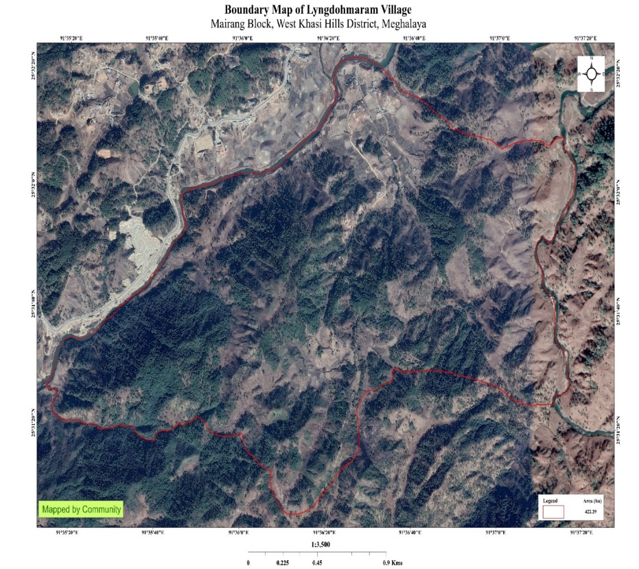
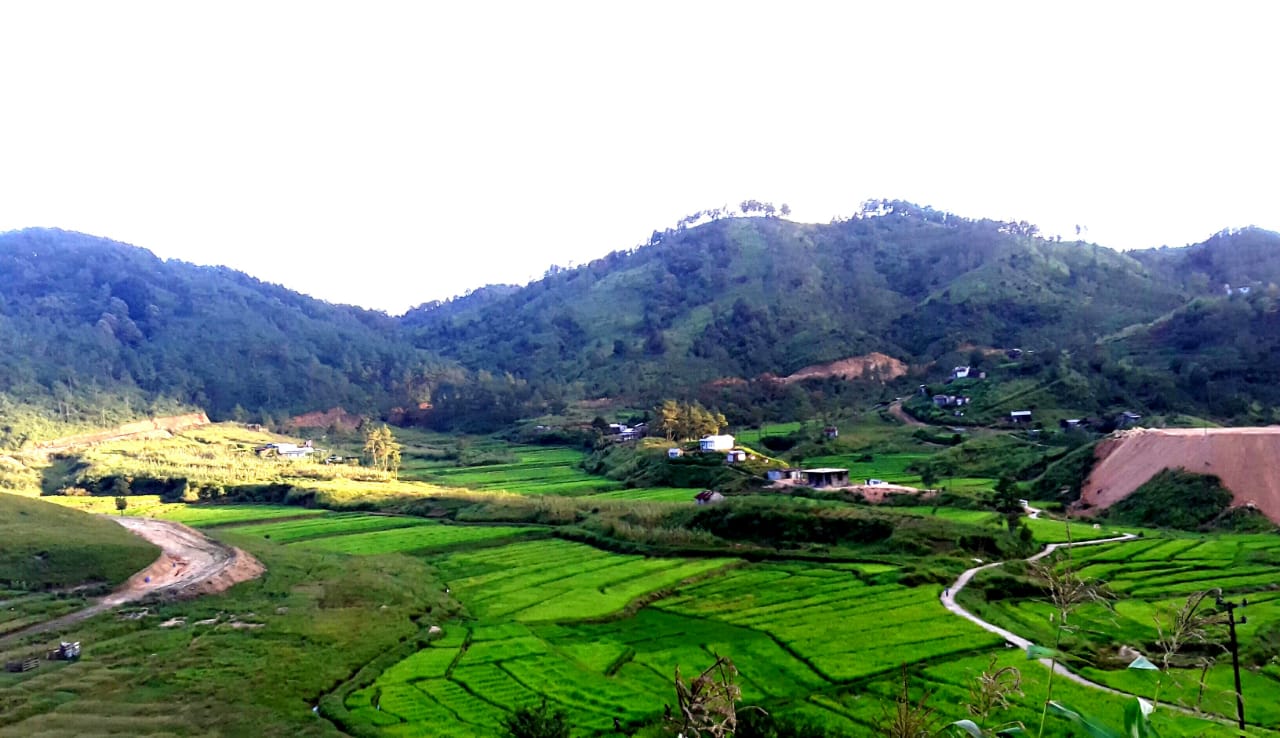
Lyngdoh Maram Village is situated in Eastern West Khasi Hills District under Mairang C&RD Block at 6kms from sub-district Mairang and 49kms away from district headquarter, Nongstoin. It was founded in 1920 and falls under Hima Khatsawphra (Nongkhlaw) with a total geographical area of 422.29ha 4.2229sqkm and a total population of 473 villagers.
 This village is surrounded by
eight villages i.e., Sangshong from the east, Langtor, Nongbah
Bynther, Sarong Demthring from the west, Madan bynther, Umthied
bynther from the north and Lyngkhoi, Demthroin from the south. In
the beginning, the residents of the village emigrated from
“Hima Maharam”,
Umsaw Marpna,
Mawkneng and Mawmaram. Their fled
was for the exploration of food for survival. The village
Lyngdohmaram took its name from the ‘first
Lyngdoh’s ritual’ of
Nongsiej family from
Maram and that’s how the name “Lyngdoh
Maram” originated. In the year 1920, there were just 4
households in the village. Nongsiej family from Hima Maharam were
the first residents in this village followed by Kharjana from Umsaw
Marpna, Wahlang from Mawkneng, Lyngdoh Mawlong and Kurbah from
Mawmaram. In the same year Shri.
Konraising Kharmawlong was elected
as the first headman of the village. As the village kept growing and
the population increased, the village established a school and the
teacher was Shri. Modwel
Nongsiej.
This village is surrounded by
eight villages i.e., Sangshong from the east, Langtor, Nongbah
Bynther, Sarong Demthring from the west, Madan bynther, Umthied
bynther from the north and Lyngkhoi, Demthroin from the south. In
the beginning, the residents of the village emigrated from
“Hima Maharam”,
Umsaw Marpna,
Mawkneng and Mawmaram. Their fled
was for the exploration of food for survival. The village
Lyngdohmaram took its name from the ‘first
Lyngdoh’s ritual’ of
Nongsiej family from
Maram and that’s how the name “Lyngdoh
Maram” originated. In the year 1920, there were just 4
households in the village. Nongsiej family from Hima Maharam were
the first residents in this village followed by Kharjana from Umsaw
Marpna, Wahlang from Mawkneng, Lyngdoh Mawlong and Kurbah from
Mawmaram. In the same year Shri.
Konraising Kharmawlong was elected
as the first headman of the village. As the village kept growing and
the population increased, the village established a school and the
teacher was Shri. Modwel
Nongsiej.
The predominant population of Lyngdoh Maram village are the Khasi. Agriculture is the main occupation of the people followed by traditional cooking of dairy food items like Putharo, Puthap, Pumaloi, etc.
The people of Lyngdoh Maram village mainly cultivate Potato (Solanum Tuberosum) and Paddy (Oryza sativa) being the main source of their revenue.
Lyngdoh Maram Village:
It has a total number of 81 households and having a population of 473 people. Agriculture and its allied activities are practised. Others are enrolled in government and teaching jobs and few inhabitants are engaged in local businesses.
Village Accessibility:
In order to reach Lyngdoh Maram village, one must venture through the Iew Mairang-Mawsawa to Umthied Bynther bye-pass road lying 6kms away from Mairang. Upon reaching the village Umthied Bynther, one must turn left in order to reach Lyngdoh Maram.
Literacy: As per the 2011 census, the village literacy rate has touched to the tune of 74.81%. There is one School in the Village i.e., Lower Primary school (founded in 1951).
Presently the village is managed and guided by its active Dorbar as the highest authority in the village which is alternatively comprised of the Seng Kynthei, (Women Wing) and Seng Samla (Youth Wing), all collectively aiming for the overall good and growth of the village. Other committees such as (1) Village Employment Council (VEC), (2) Village Water and Sanitation Committee, (3) Village Organisation (VO), and (4) Self-Help Groups (SHGs) are constantly active and vigil as well, working in due co-operation between themselves for a brighter tomorrow of the village.
1. Population: As per Census 2011, Lyngdoh Maram population is 339 and in 2020 the total population of Lyngdoh Maram has increased to 473. Out of this, 251 are male while the female count is 222. The village has 55 children in the age group of 0-4 years. Among them 21 are boys and 34 are girls.
| Age Group | Male | Female | Total |
|---|---|---|---|
| 0-4 | 21 | 34 | 55 |
| 5-14 | 45 | 42 | 87 |
| 15-30 | 79 | 63 | 142 |
| 30-60 | 90 | 75 | 165 |
| Above 60 | 16 | 8 | 24 |
BPL/APL Household:
| Particulars | No. of HH |
|---|---|
| BPL HH | 45 |
| APL HH | 14 |
2. Card Holding Household:
| Particulars | No. of HH |
|---|---|
| Total HH | 81 |
| Ration Card HH | 64 |
| Health Card HH | 75 |
Fuel Type:
| Fuel Type | Total HH |
|---|---|
| Charcoal | 5 |
| Biomass | 0 |
| Wood | 450 |
| LPG | 10 |
| Electric Heater | 5 |
| Kerosene | 3 |
 3.
Occupation:
3.
Occupation:
The people of the village rely on agriculture and forest products for their livelihood. The main occupation of the villagers is farming followed by teaching, self-employed, taxi driving, Government servant and daily labourer.
Transportation: Transportation is difficult since the taxi stand is not connected with the road of the village.
 Deforestation:
Forest cover keeps on decreasing due to deforestation activities in
this area.
Deforestation:
Forest cover keeps on decreasing due to deforestation activities in
this area.
Flood: During rainy season the village faces a huge problem of flooding in the paddy fields and footpaths.
| Water Bodies | No |
|---|---|
| Streams | 5 |
| Rivers | 1 |
| Land | No |
| Forest | 6 |
| Cultivable Land | 7 |
1. Ground Truthing:
The DPMU-CLLMP members met with Shri. Willson Lyndoh Mawlong, President VNRMC Lyngdoh Maram Village and other village representatives for field assessment on the 20th July, 2019. Shri. Willson Lyngdoh Mawlong provided the team with important information regarding the current scenario of the landscape and the natural resource management under his leadership.
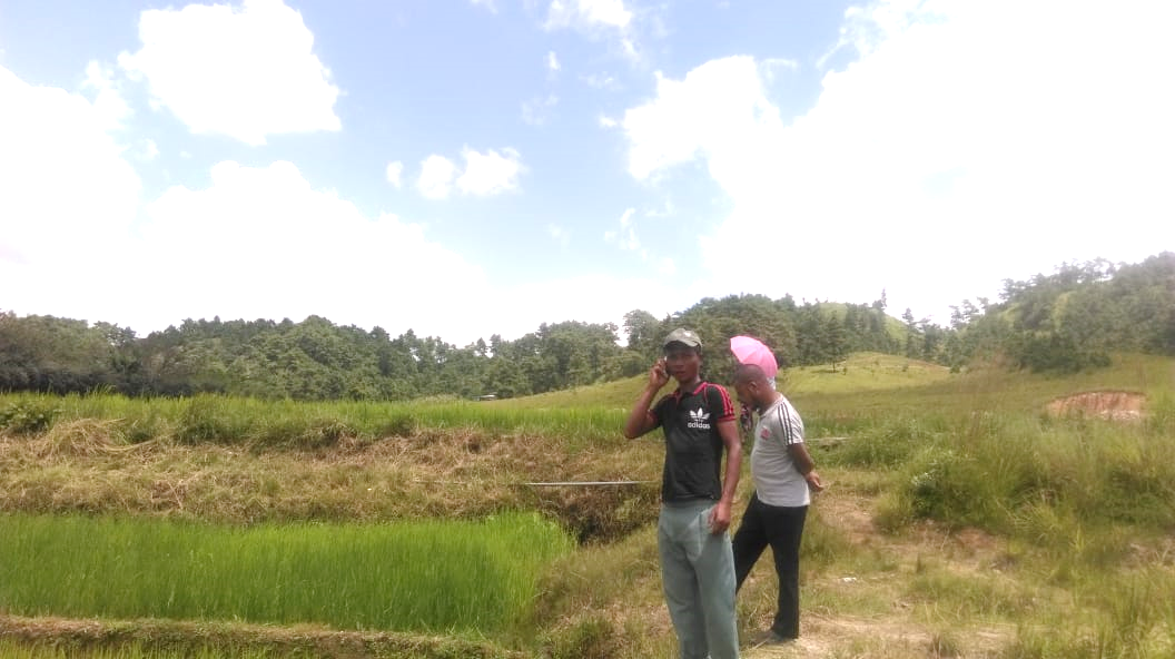
Fig 1. Ground Truthing at Lyngdoh Maram Village
Case Findings:
There are a total of 81 households out of which 45HHs (approx.) fall under the BPL category.
Actively performing VEC.
Most of the land falls under private sector.
They have plenty sources of water supply.
Few patches of degraded land have been left unused.
Forest on hill slopes is safe.
Abundance of small streams.
2. Sensitization Programme:
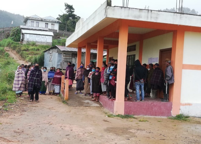
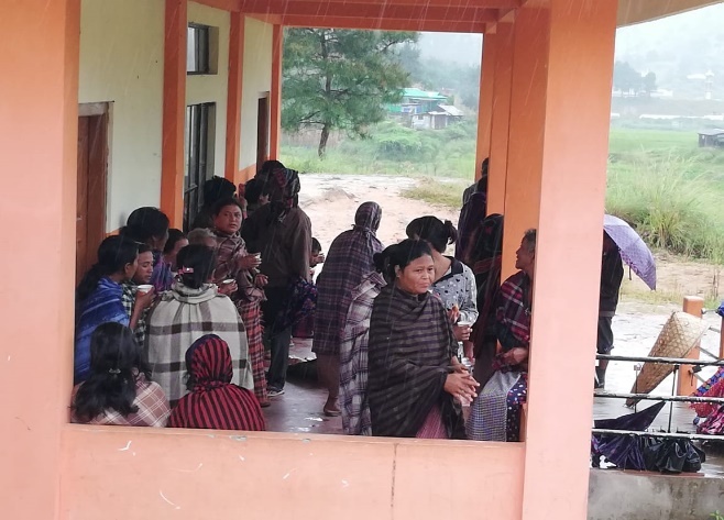 The District Project Manager
and the Assistant Managers held a village level Sensitization
Programme on the Community Led Landscape Management Project (CLLMP)
on the 22nd July, 2019. The villagers actively
participated in the program, voiced out their concerns and questions
regarding the project and made it a huge success.
The District Project Manager
and the Assistant Managers held a village level Sensitization
Programme on the Community Led Landscape Management Project (CLLMP)
on the 22nd July, 2019. The villagers actively
participated in the program, voiced out their concerns and questions
regarding the project and made it a huge success.
Fig 2: Sensitization Program
Highlights of the Meeting:
Awareness about Community–Landscape Management project
Laying importance on the involvement of the community in making the CNRM plan and its success
A brief awareness on cleanliness was conducted based on the findings during the ground truthing phase
An interactive session was held to answer the doubts of the villagers regarding the project.
2.1. Signing of EOI, VGA and Green Charter:
Lyngdohmaram Village signed the Expression of Interest (EOI), the Village Grant Agreement (VGA) and the Green Charter after a uniform agreement by the enitre community that the Community-Led landscape Management Project (CLLMP) be implemented at Lyngdohmaram Village.
2.2. Formation of the VNRMC:
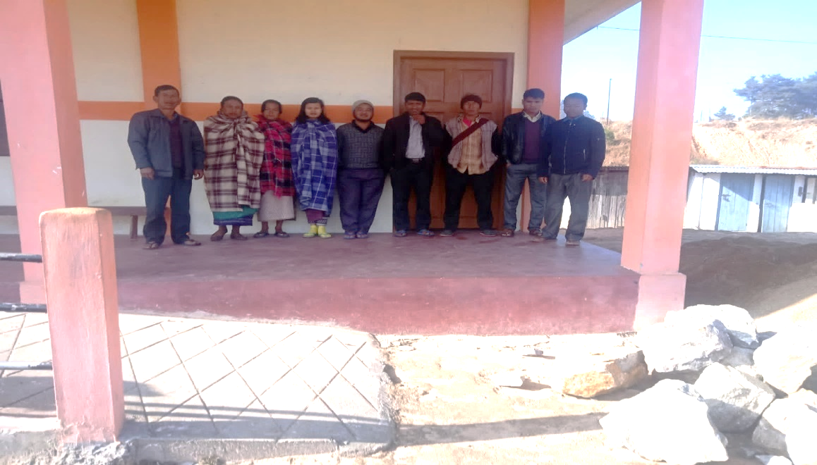
The Formation of the Village Natural Resource Management Committee (VNRMC) was done on the 20th July, 2019, in a public meeting in the presence of the entire village and the CLLMP staffs. The community chose the President, the Secretary, and other executive members of the Committee.
Listed below are the members of the VNRMC:
|
||||||||||
|---|---|---|---|---|---|---|---|---|---|---|
| Sl. No. | Name in Full | Designation | Gender M/F | Age (Yrs) | Education | Occupation | Community | Religion | Contact No | |
| 1 | Wilson Lyngdoh Mawlong | President | Male | 38 | BA | Teacher SSA | Khasi | Christian | 8837063830 | |
| 2 | Rikynti Wahlang | Secretary | Female | 24 | BA | Student | Khasi | Christian | 8974942748 | |
| 3 | John Franky Ryntathiang | Member | Male | 34 | XII | Farmer | Khasi | Christian | 7005456184 | |
| 4 | Stilang Kharjana | Member | Male | 38 | BA | Farmer | Khasi | Christian | 8837457227 | |
| 5 | Phransis Wahlang | Member | Male | 43 | IV | Farmer | Khasi | Christian | 7085618666 | |
| 6 | BanstarmenLyngdoh Mawlong |
Member | Male | 27 | XII | Farmer | Khasi | Christian | 9612960810 | |
| 7 | Drillina Lyngdoh Mawlong | Member | Female | 35 | BA | Farmer | Khasi | Christian | 6009303405 | |
| 8 | Shorbing Warjri | Member | Male | 50 | - | Farmer | Khasi | Christian | 9612367581 | |
| 9 | Kiamci Wahlang | Member | Female | 45 | MA | Teacher | Khasi | Christian | 9378051571 | |
Fig. 3. The Village Natural Resource Management Committee (VNRMC).
| Village Community Facilitators | ||||||
|---|---|---|---|---|---|---|
| Sl.No. | Name | Gender | Age | Education | Contact Number | Role |
| 1 | Banstarmen Lyngdoh Mawlong | M | 27 | XII | 9612960810 | KM and SM VCF |
| 2 | John Franky Ryntathiang | M | 34 | XII | 7005456184 | Evt & GIS VCF |
| 3 | Drillina Lyngdoh Mawlong | F | 35 | BA | 6009303405 | M&E and PM VCF |
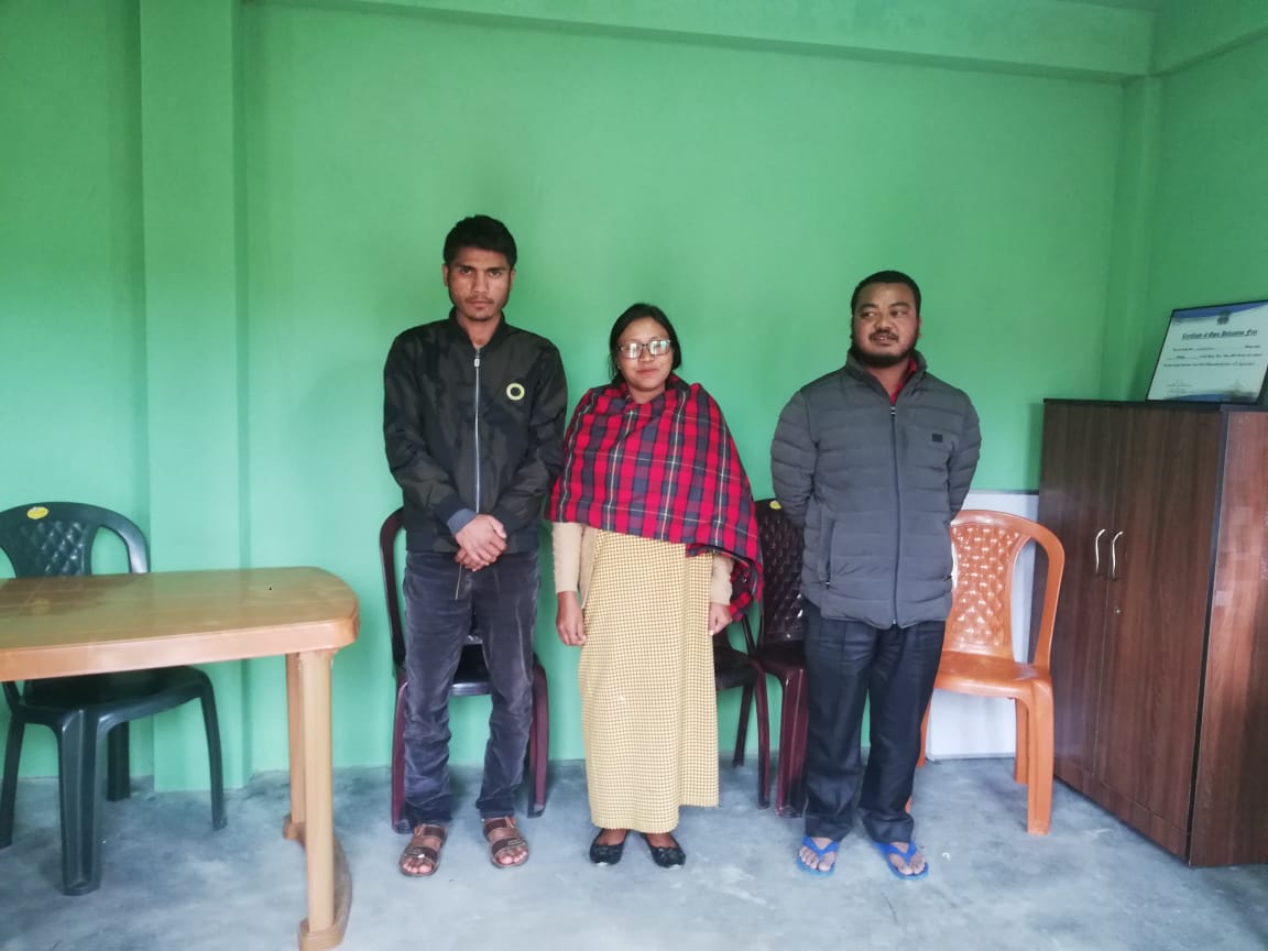
Fig. 4. The Village Community Facilators (VCF).
| List of Procurement members | |||||
|---|---|---|---|---|---|
| Sl. No | Name | Gender | Age | Education | Contact Number |
| 1 | Phransis Wahlang | M | 43 | IV | 7085618666 |
| 2 | Brik Nongsiej | M | 50 | NA | 8837435783 |
| 3 | Kwen Nongsiej | F | 48 | NA | NA |
Fig. 5. The Procurement Committee Members.
3. Opening of Bank Account
The opening of the bank account was done after the signing of the EOI (Expression of Interest), the VGA (Village Grant Agreement) and the signing of the Green Charter at the respective villages.
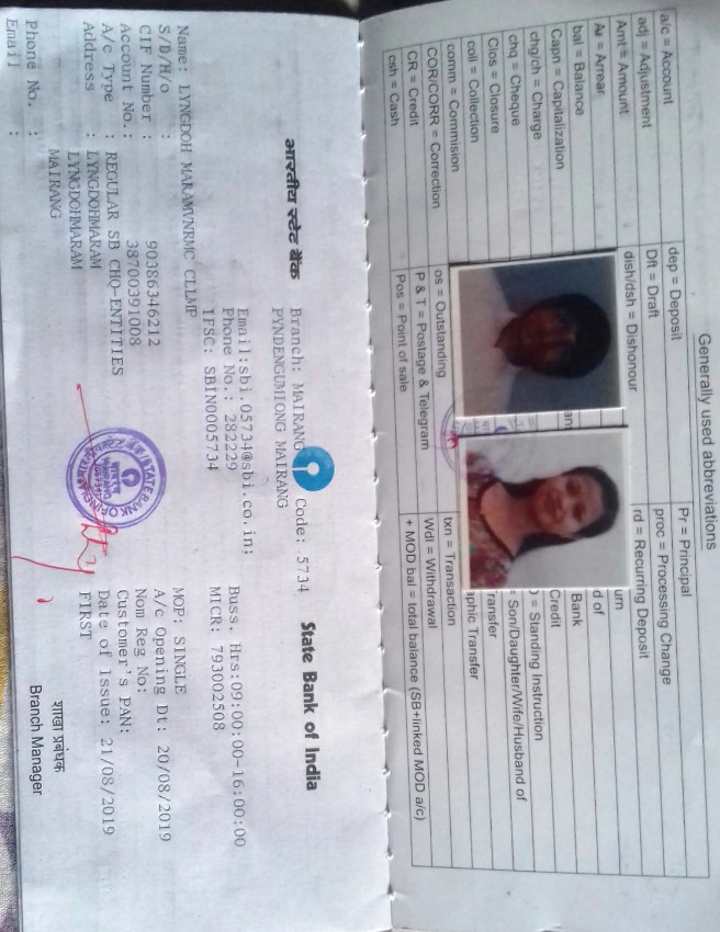 A meeting was held for
all the VNRMC members of Lyngdohmaram to brief and assist them
before opening the VRNMC bank account. The bank account was opened
on 28th August 2019.
A meeting was held for
all the VNRMC members of Lyngdohmaram to brief and assist them
before opening the VRNMC bank account. The bank account was opened
on 28th August 2019.
4. Participatory Rural Appraisal Exercise:
The PRA exercise aims to incorporate the knowledge and opinions of the community in the planning and management of development projects and programmes. The PRA exercise at Lyngdoh Maram Village took place on the 29th August, 2019, were the villagers, both men and women included, took part in the exercise.
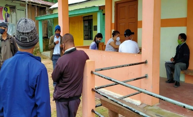
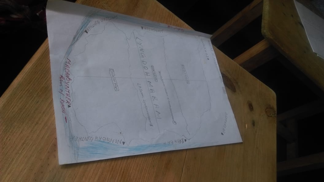
Fig. 6. PRA Exercise at Lyngdoh Maram Village.
The initial stage of Participatory Rural Appraisal (PRA) exercise at Lyngdoh Maram Village commenced with a meeting cum orientation program on CLLMP. While conducting the meeting, the community members were made aware of the various PRA exercises to be conducted for the development of the Community Natural Resource Management Plan (CNRMP) of the village, the community members’ contribution in the exercise and the objectives to be achieved. The key informants being the VNRMC and the VCFs helped facilitate maximum participation.
Commencement of PRA.
Introduction: Participatory Rural Appraisal (PRA) is the process of involving local people in the analysis and interpretation of their own situation of a given rural area. The local people i.e., the participants take a leadership role in collecting, analysing, interpreting, and presenting information and in this process impart knowledge and development insight to the specialists and extension agents
For management of natural resources, Participatory Rural Appraisal is conducted to establish rapport with the village community as well as to identify and define problems for prioritization in the village itself. It is a way of learning from and with community members to investigate their need assessment, analyse and evaluate constraints and opportunities and find out priorities in the area of agriculture, small scale rural enterprises and any other social and economic development programs addressed to the village development based on the principle of listening and learning.
Objectives of PRA exercise at Lyngdoh Maram Village:
The Participatory Rural Appraisal (PRA) exercise at Lyngdohmaram was conducted with the following objectives:
To identify the natural, human, and economic resources of village.
To identify the village problems and prioritize them with the help of the community members.
To prepare the Community natural Resource Management Plan of the village.
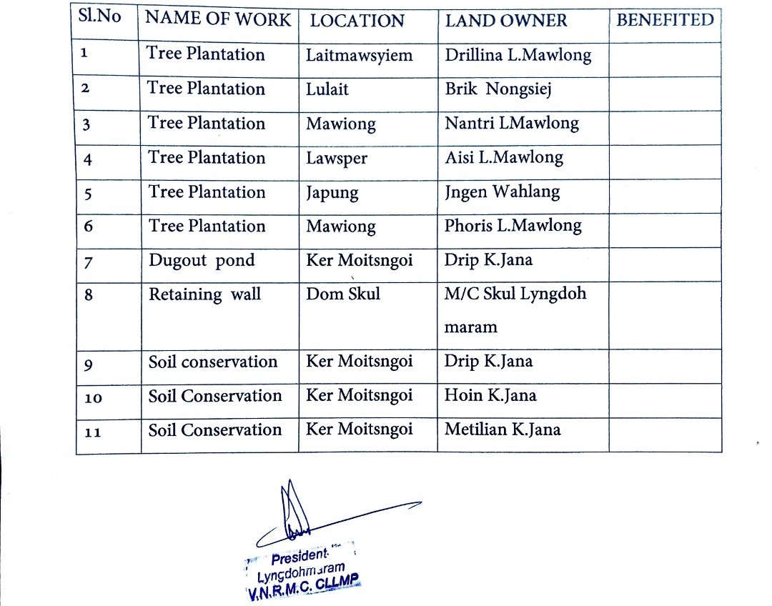
Activity 1: Village Boundary Mapping and drawing the Resource Map:
The Village Community Facilitators mapped the village boundary of Lyngdohmaram Village.
The second step is to involve the local community in preparation of village resource map as perceived by the community members to solicit their participation. Infrastructure, services and other village resources such as agricultural lands, wells, wastelands, cattle population etc. were mapped. Local people prepared the Resource Map by drawing it on a chart paper without much interference from outsiders.
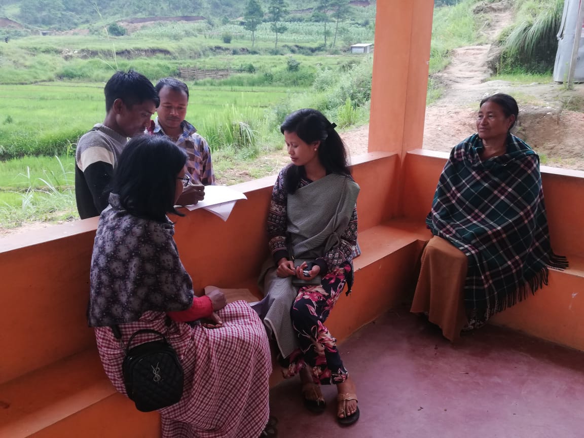
Fig. 7. Village Boundary Mapping.
This activity achieved the following purposes:
Rapport building and won the confidence of the villagers.
Analysed the spatial information, particularly studied problems and opportunities of villagers.
Got an impression about the village setting, physical layout, location of various houses and institutions.
Findings Based on the Resource Map of Lyngdoh Maram Village:
Main agriculture produce is Paddy and potato.
There are 2 types of Forest ownership:1 community forest and 7 private forests
One river Wah Kynshi is present and flow through the village paddy field.
Presence of Barren land.
Presence of Community Hall.
Presence of Football playground.
Presence of Integrated Child Development Services (ICDS).
Ten dugout ponds for fisheries.
Two water pumping (tube well).
School: There is only one School. L.P school in the village.
There is only one church.
Habitation is not confined to one place but spread all over the village.
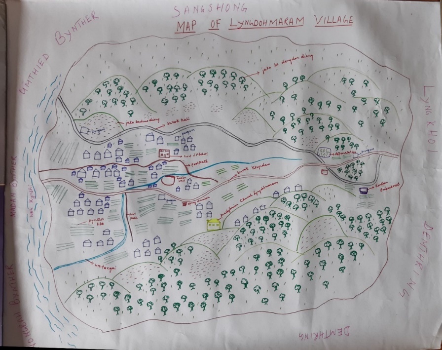
Fig. 8. Resource Map Drawn by the Community Members
Activity 2: Baseline Data Survey to fill the Environment and Social Template:
During the PRA exercise, the External Experts of Social & Environment Management held group discussions with different groups to gather basic village information regarding number of households, demographic information, major crops and enterprises taken in the village, trends of production and productivity of major crops in the village and demographic distribution of village population.
Information related to land use category such as forest, cultivable land, water bodies, etc and problems and challenges related to NRM were discussed.
Activity 3: Focussed Group Discussion on Problem Analysis:
Do people have sufficient access to supply of fodder, fuel wood, leaf litter?
Yes, people in the village have sufficient access to supply of fodder, fuel wood, and leaf litter. They get it from the community forest and from their own private lands/forest.
Has access to timber improved or reduced over the years? How is access for household use and commercial use managed?
Access to Timber has reduced over the years. People in the village get it only from private land which is not enough. They must purchase it when needed.
Are the water bodies facing any threats?
No.
Do all people in the village have access to drinking water? What are the challenges?
Yes
Are there degraded areas in the village (open/ degraded forests, mining affected, high soil erosion etc.)?
There are some minor degradations in cultivated land.
What has caused this degradation? Are there practices causing threats to availability and access to natural resources?
Fertility of the soil decline over the year.
Excessive practice of Jhum Cultivation.
What have been the changes in agricultural practices?
Over the years the people in the village they have increased their agricultural production. Previously they mainly cultivate paddy.
Are there any challenges in farming?
No
How would you consider the health situation in your village?
The nearest CHC is at the distance of 6Km which is easily accessible for the community in the village.
How is the situation of cleanliness, sanitation, access to toilets and waste management?
The Dorbar committee is responsible for organizing the cleaning drive of the village, once a year.
Sufficient toilets are available in every household but most of the constructions are poor. Some households have access to toilets from SBM (Swash Bharat Mission) scheme.
Who are the most vulnerable in the village? What can be done to improve their lives?
BPL Families. Inclusion of BPL family members during project implementation.
What are the livelihood aspirations of the youth? Are there any avenues available?
None, except daily wages.
Do any committees/ institutions/ rules exist to manage and monitor natural resources in the village?
The VNRMC under the CLLMP is the main committee that is now in place to manage the natural resources in the village.
What are some of the major issues of conflict in the village?
Nothing related to NRM.
Have any of the above issues been discussed in village meetings?
NA
How do people resolve disagreements and conflicts?
All disagreements and conflicts are addressed by the traditional institution of village called the Village Dorbar.
Activity 4: Seasonality Calendar:
The CLLMP team also mapped the seasonal calendar of Lyngdoh Maram Village to help identify heavy workload periods, periods of relative ease, credit crunch, diseases, food security, wage availability etc. This will prove helpful in project planning and project timeline framing.
Participants:
1. Shri. Stilang Kharjana – Headman of Lyngdoh Maram Village.
2. Shri. Wilson Lyngdoh Mawlong – President of VNRMC.
3. Smt. Rikynti Wahlang – Secretary of VNRMC.
4. Shri. John Franky Ryntathiang – Village Community Facilitator
5. Smt. Kiamci Wahlang - VNRMC Member.
| SEASONAL CALENDAR | |||||||||||||
|---|---|---|---|---|---|---|---|---|---|---|---|---|---|
| Sl. No. | Criteria | Jan | Feb | Mar | Apr | May | Jun | Jul | Aug | Sep | Oct | Nov | Dec |
| 1 | Water Scarcity | 1 | 2 | 2 | 2 | 1 | 1 | 1 | 1 | 1 | 1 | 1 | 1 |
| 2 | Prone to sickness | 1 | 1 | 1 | 1 | ||||||||
| 3 | Seeking job outside | 1 | 1 | 2 | |||||||||
| 4 | Rain Fall | 3 | 3 | 3 | 3 | 2 | 1 | 1 | 1 | 2 | 2 | 3 | 3 |
| 5 | Free – Less work | 1 | 2 | 2 | |||||||||
| 6 | Paddy Cultivation | 1 | 1 | 1 | |||||||||
| 7 | Paddy harvesting | 1 | 1 | 1 | |||||||||
| 8 | Betel Nut Cultivation | ||||||||||||
| 9 | Betel Nut Harvesting | ||||||||||||
| 10 | Tree Plantation | 3 | 2 | 1 | |||||||||
| 11 | Vegetable (crop cultivation) | 1 | 1 | 1 | |||||||||
| 12 | Vegetable (crop harvesting) | 3 | 3 | 2 | 2 | 1 | 1 | ||||||
| 13 | Festive Season | 1 | 2 | 3 | |||||||||
| 14 | Forest fire | 1 | 2 | ||||||||||
| 15 | Collection of Fuel wood | 1 | 2 | 3 | 2 | ||||||||
| Maximum | 1 |
|---|---|
| Moderate | 2 |
| Less | 3 |
 5. Submission
of CNRMP:
5. Submission
of CNRMP:
5.1. Final CNRMP:
|
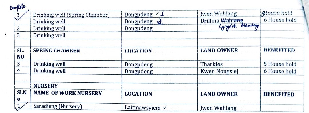
Name of Proposed Interventions | Site |
|
Nos of HHs expected to Benefit | Priority (High/ Medium/ Low) | ||
|---|---|---|---|---|---|---|---|
|
|
|
|||||
| 1 |
|
Khliehshnong |
|
|
|
|
|
| 2 |
|
Dongpdeng |
|
|
|
|
|
| 3 |
|
Laitmawsyiem |
|
|
|
|
|
| 4 |
|
Dongpdeng |
|
|
|
|
|
| 5 |
|
Ummylluh |
|
|
|
|
|
| 6 |
|
Laitmawsyiem |
|
|
|
|
|
| 7 |
|
Khliehshnong |
|
|
|
|
|
| 8 |
|
Dongpdeng |
|
|
|
|
|
6. GIS Activities:
| Sl. No. | Parameters | Village Information |
|---|---|---|
| 1 | GPS Coordinates: | |
| i | Latitude | 25.535017N |
| ii | Longitude | 91.609485E |
| iii | Elevation Reading (MSL) | 1754m |
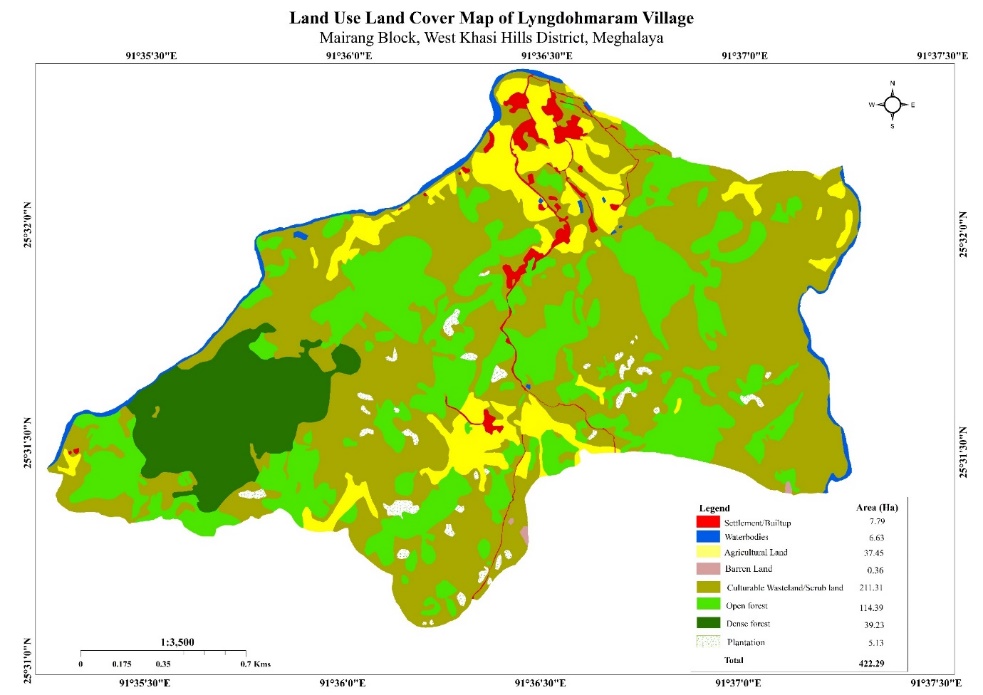
| 2 | Village Geographical Area (Ha) | Total:422.29Ha 4. 2229sq.Km |
| i | Total Forest Area (including community, Clan, Pvt Forest) | 153.62Ha |
| ii | Total Area of Water Bodies | 6.63Ha |
| iii | Total Area under Agri-Horticulture | 5.13Ha |
| iv | Total Degraded land area (Ha) | 0.84Ha |
| 3 | Average Annual Rainfall | 1200-3000mm |
| 4 | Soil Type | Course Loamy Soil |
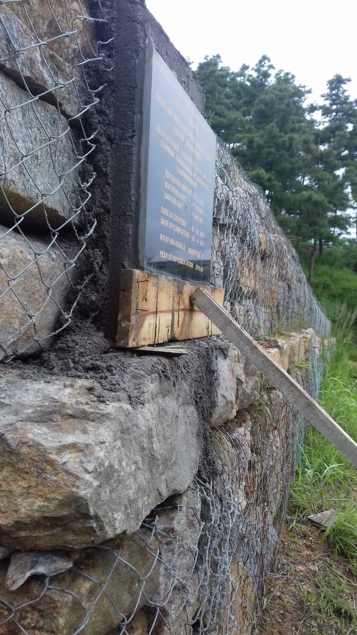
7. Project Implementation:
| Sl No. | Type of Intervention | Site name | GPS Coordinates (latitude) | GPS Coordinates (longitude) | Amount Sanctioned | Work status |
|---|---|---|---|---|---|---|
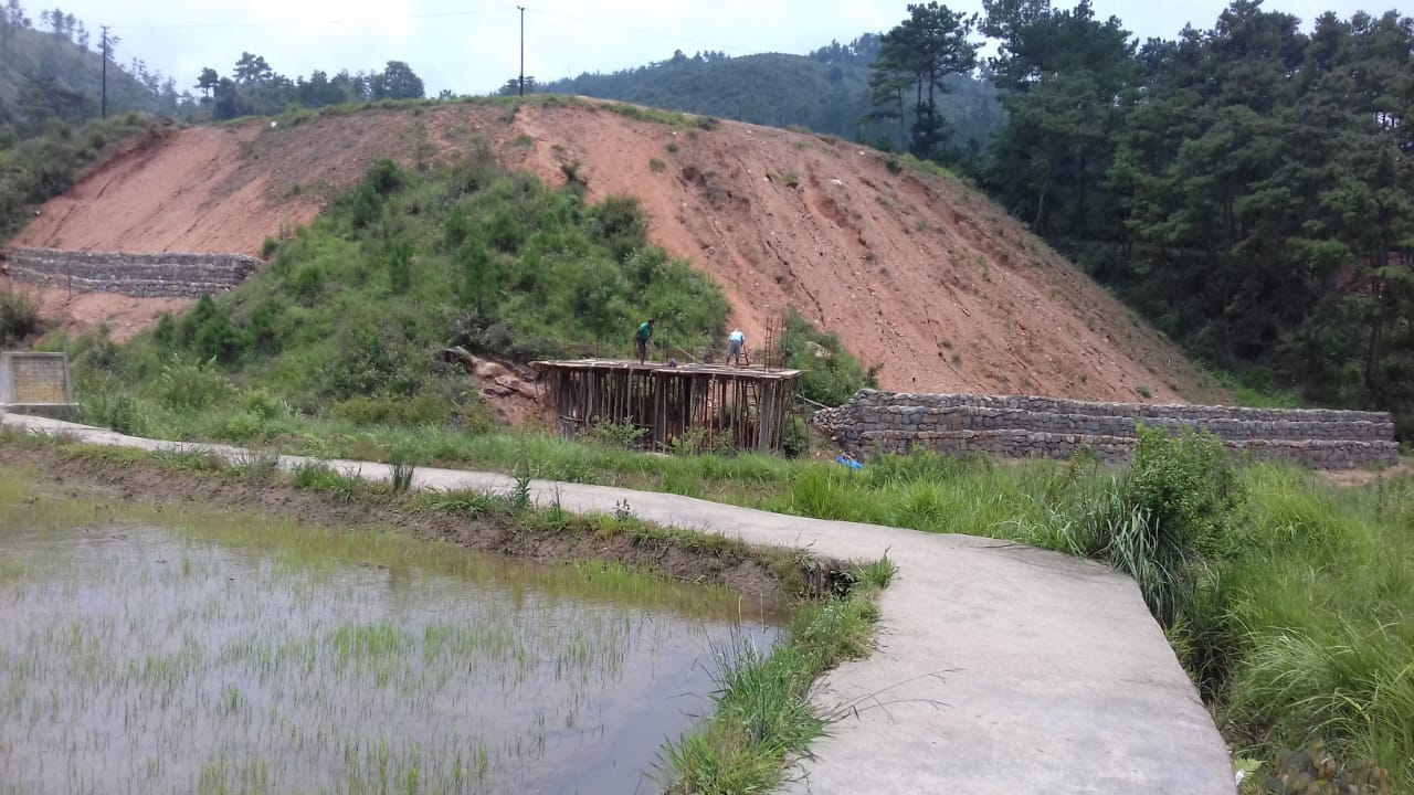
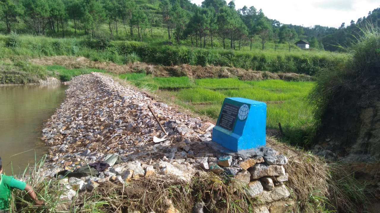
| 1 | Erosion control gabion wall | Dongpdeng | 25.535237° | 91.609073° | 3,35,200 | Completed |
| Sl No. | Type of Intervention | Site name | GPS Coordinates (latitude) | GPS Coordinates (longitude) | Amount Sanctioned | Work status |
|---|---|---|---|---|---|---|
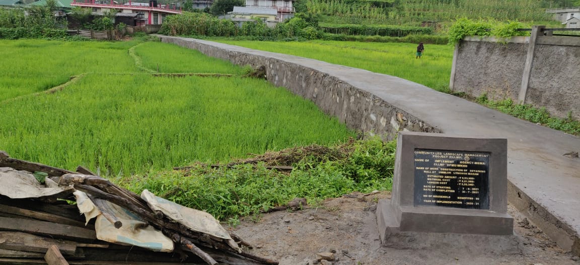
| 2. | Earthen embankment with boulders core wall | Laitmawsyiem | 25.52532083 | 91.60625528 | 1,89,900 | Completed |

| Sl No. | Type of Intervention | Site name | GPS Coordinates (latitude) | GPS Coordinates (longitude) | Amount Sanctioned | Work status |
|---|---|---|---|---|---|---|
| 3. | Retaining wall | Ummylluh | 25.53757722 | 91.60782222 | 5,53,900 | Completed |
| Sl No. | Type of Intervention | Site name | GPS Coordinates (latitude) | GPS Coordinates (longitude) | Amount Sanctioned | Work status |
|---|---|---|---|---|---|---|
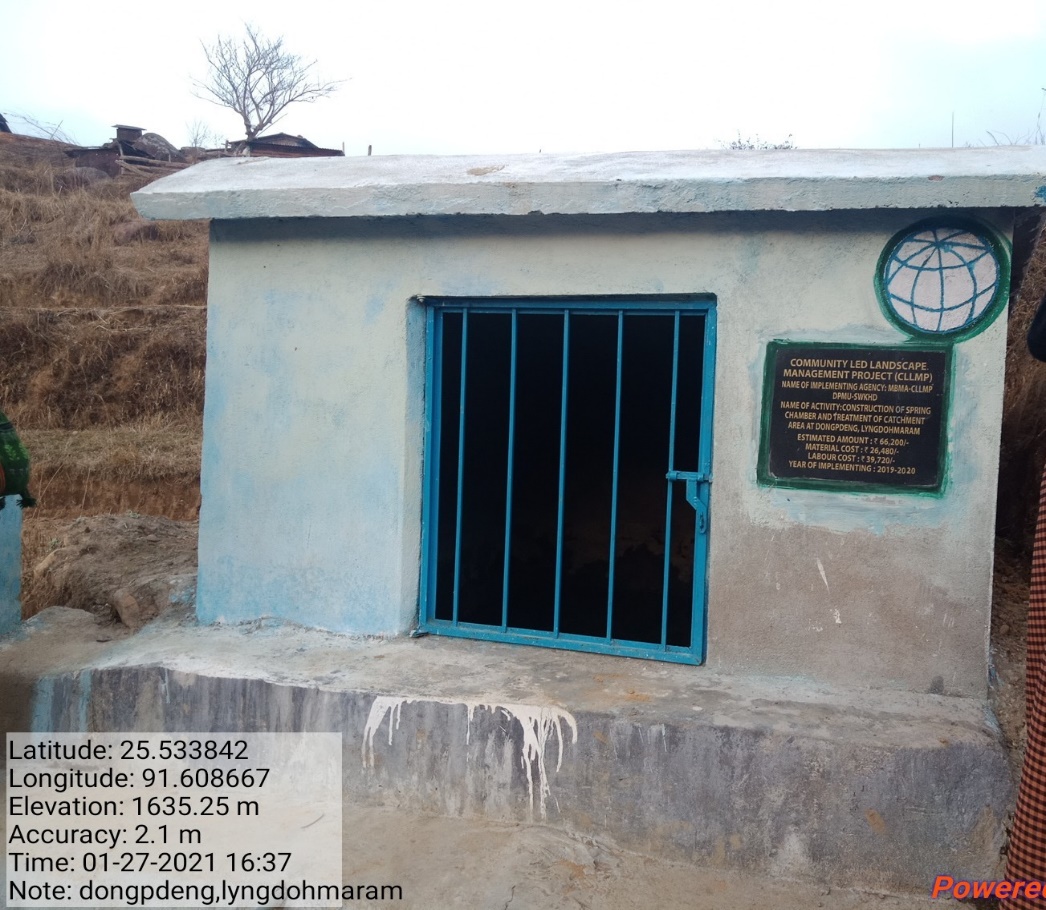
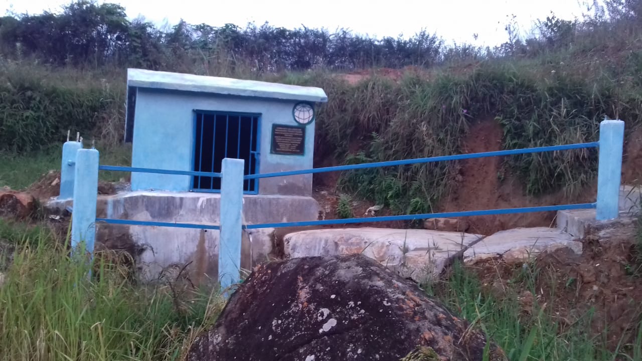
| 4. | Spring Chamber | Dongpdeng | 25.529423° | 91.606539° | 85,600 | Completed |
| Sl No. | Type of Intervention | Site name | GPS Coordinates (latitude) | GPS Coordinates (longitude) | Amount Sanctioned | Work status |
|---|---|---|---|---|---|---|
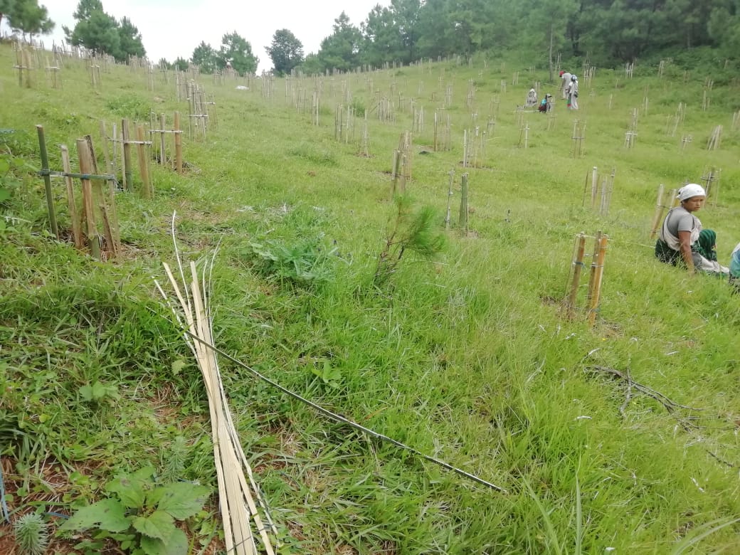
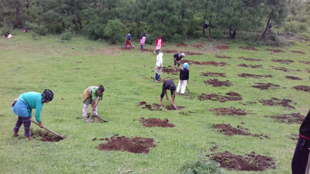
| 5. | Afforestation | Khlieh shnonng | 25.52625056 | 91.60983222 | 59,750 | Completed |
| Sl No. | Type of Intervention | Site name | GPS Coordinates (latitude) | GPS Coordinates (longitude) | Amount Sanctioned | Work status |
|---|---|---|---|---|---|---|
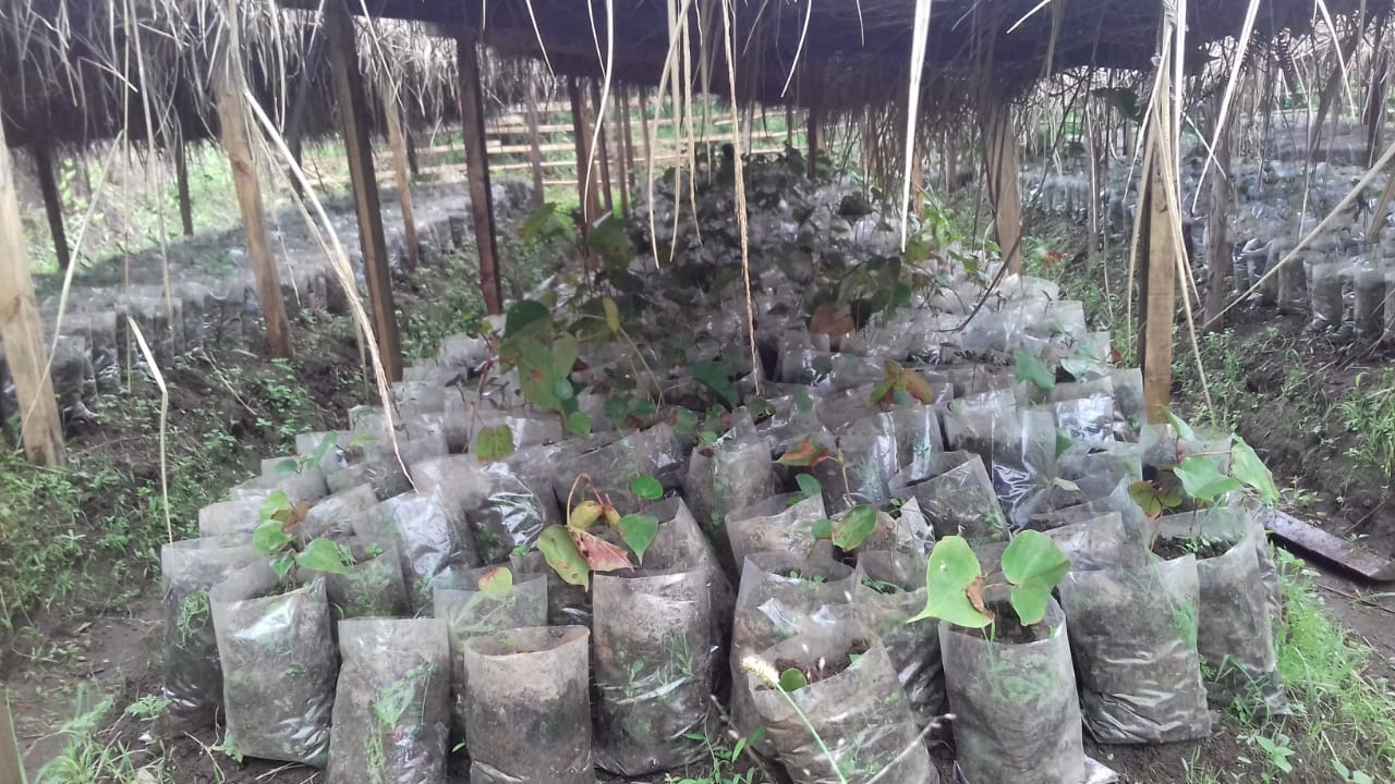
| 6. | Community Nursery | Laitmawsyiem | 25.52566333 | 91.60485361 | 1,61,650 | Completed |

8. Fund Status:
| Fund Released to VNRMC (Project Implementation) | Total No. of Work Order Issued | Total amount Issued under CLLMP (Per Activity) | Total Amount Spent | Start Date | End Date |
|---|---|---|---|---|---|
| ₹ 24,95,437/- | 12 | Afforestation | 59,719 | 06-Jul-20 | 14-Sep-20 |
| Erosion Control Gabion Wall | 3,35,200 | 21-Dec-20 | 30-Apr-21 | ||
| Earthen Embankment with Boulders core wall and lining | 1,89,573 | 07-Jul-20 | 01-Sep-20 | ||
| Spring Chamber with TCA (Spring Chamber) |
65,493 | 17-Aug-20 | 03-Sep-20 | ||
| Spring Chamber with TCA (Recharge Pit) |
572 | 17-Aug-20 | 03-Sep-20 | ||
| Retaining Wall | 5,53,900 | 30-Jul-21 | 18-Aug-21 | ||
| Community Nursery | 1,61,650 | 16-Jul-21 | 30-Aug-21 | ||
| Spring Chamber | 34,072 | 14-Oct-21 | 04-Jan-22 | ||
| Erosion Control Retaining Wall | 4,87,100 | 03-Jan-22 | 10-Mar-22 | ||
| Water Conservation Pond | 352900 | 11-May-22 | 18-Jul-22 | ||
| Vermi Compost of 4 Units | 1,53,430 | 31-Jul-22 | 30-Aug-22 | ||
| Erosion Control Retaining Wall | 1,01,828 | 21-Nov-22 | 28-Jan-23 | ||
| TOTAL AMOUNT SPENT | ₹ 24,95,437/- | ||||