Report of Moorapushai Village
District: West Jaintia Hills
Block: Thadlaskein Block
Date: 21st March 2023
COMMUNITY LED LANDSCAPE MANAGEMENT PROJECT


COMMUNITY LED LANDSCAPE MANAGEMENT PROJECT (CLLMP)
The Government of Meghalaya with financial help from the World Bank is implementing the Meghalaya Community Led Landscape Management Project (MCLLMP). The project covers the entire state of Meghalaya, and implementation of community-led plans are rolled out in a phased manner throughout the state. The Meghalaya Basin Management Agency (MBMA) will facilitate community-led planning by providing support, technical inputs and funding.
The project is intended to strengthen community-led natural resources management in selected landscapes within the 7 districts of the state. This would be achieved through a variety of planning, capacity building, and on-the-ground interventions to promote the conservation, sustainable use of natural resources, social inclusion and community mobilization; building traditional knowledge and learning, mapping of natural resources management; strengthening the community institutions and creating linkage with financial institutions and community organizations.
The project interventions will include preparation of community led natural resource management plans. The CLLMP has the following three components:
Strengthening Knowledge and Capacity of Communities for Natural Resources Management
Community-Led Landscape Planning and Implementation
Project Management and Governance
The project objective is “to manage and conserve the natural resources, especially forests, soil and water sources, in a manner that supports the financial and physical well-being of communities in the State”
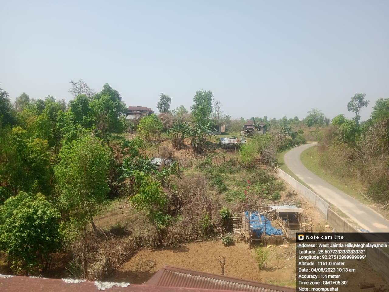
Moorapushai Village is located in Nongjngi Community and Rural Development (C&RD) Block of West Jaintia Hills district in the state of Meghalaya. Agriculture is the main profession of this village and does not have any industrial development. The People of this area is very peaceful without taking much issues and problems to think about the external affairs. They are confined to what they have been doing and comfortable with their daily schedule.
According to the history, the village has been originated for 255 years. During those days, there were no education system and they had to walk miles and miles away to travel from one place to another. The community are mainly into farming as they work on paddy cultivation, plantation of vegetables, etc. And later after many years, the village was extended to the large society and people came to start their family and the household has been extended with more population.
Moorapushai Village is located in Nongjngi Community and Rural Development (C&RD) Block of West Jaintia Hills, Meghalaya, India. It is about 30 Km away from Nongjngi C&RD Block Office and 36 Km from district headquarter Jowai west Jaintia hills District, Meghalaya. the village is inhabited by the Pnar community with 97 households and a population of 660. The gender ratio in the village is 344 females and 36 males. The land ownership of the village is largely under private lands owned by the individuals. The main institutions of the village are the dorbar, the Village Employment Council (VEC), and one Self Help Group (SHG).There are committees of the Seng Jiantia Committee, the Church Committee and the School Managing Committee. There is no Water and Sanitation Committee in the village. As per data the collected, all the 175 households (HHs) use firewood for meeting the fuel needs with an average consumption of 3000 kg per household per annum.
 .
.
The major occupations in the village were farmer, daily wages, teacher and business.
WATER BODIES
Springs- 7
Stream- 6
LAND
Forest-193.89 Ha
Water Bodies- 4.59 Ha
Agri-Horti- 173.7Ha
Barren Land-0.79 Ha
Safe drinking Water
Irrigation System
Degraded Land
Water Shortage in Winter Session
Clearance of forest for expansion of settlement
Ground truthing and village level sensitization programme was held at Moorapuchai under Thadlaskein Block on 18.09.2020. There were many members participated for the programme. The community decided to have a meeting with the entire village members and discuss about the project, formation of VNRMC, EC and Village facilitators.
1. There is less amount of water during winter season.
2. Transportation facilities: There is very less transportation
3. Banking Facilities: Banking facilities is also a part of their challenges
4. Public health centre is very limited
5. There is less fertility
6. Conflicts and Disagreements in the village is being handled by the Village Council.
The list of indigenous tree species are – Kseh, chyrngan (Schimawallichii), rytiang, dieng sning, sohpieng (Mangiferaindica) Sachram (Artocarpusheterophyllus)saphoh,slya,sohiong,(Prunusnepalensis), sapriam(Psidiumguajava).
The Valuable grasses of the village are- Phlanglum,Shkenkhian
Signing of Documents:
After few days of sensitization programme, on the 29.09.2020 the district DPMU and SPMU visited Moorapuchai Village for signing of all the documents such as EOI, VGA and CGC.
Formation of VNRMC
The formation of VNRMC, EC members and VCF were been done on the 20th of September 2020 wherein the community decided to select the representatives from VEC, SHG and other village functionaries.
Listed below are the members of the VNRMC:
| Village Natural Resource Management Committee (VNRMC) | ||||||||
|---|---|---|---|---|---|---|---|---|
| Sl No | Name in Full | Gender M/F | Age (in Yrs) | Education | Designation | Occupation | Community | Contact No and email address |
| 1 | Mr. Roling Pulang | M | 27 | HSSLC | P.C | Labour | Pnar | 6009373340 |
| 2 | Smt.Kersila Niang | F | 23 | B.A Passed | P.C | Student | Pnar | 6002734497 |
| 3 | Smt Yowanka Niang | F | 30 | Graduate | P.C | Teacher | Pnar | 7005193049 |
Village Facilitators (VCF)
| Sl No | Name in Full | Gender M/F | Age (Yrs) |
Education | Area of specialisation/ focus (forests, water, soil, accounts, environmental and social safeguards, knowledge management, GIS) | Trained under CLLMP (Yes/ No?) if yes, date training was received | Contact No and email address |
|---|---|---|---|---|---|---|---|
| 1 | Wanbiang Pulang | M | 24 | Graduate | Environment | No | 7085229222 |
| 2 | Arphi Hadia | F | 20 | Graduate | Social | No | 6909063007 |
| 3 | Syntruin Daw | M | 50 | Graduate | M & E | No | 7085229222 |
PRA exercise was conducted on the 18th September 2020 at Moorapuchai Village, Thadlaskein Block, WJH.
Plan Estimate:
The plan estimate is done once field engineer along with the Environment Management pay a visit to the proposed sites for inspection. On approval, the plan estimate is being carried out further by the district field engineer.
| Type Of Intervention | Site Name | GPS Co-ordinates | Plan Estimate | Work Status | ||
|---|---|---|---|---|---|---|
| 1 | Recharge Pit | Umwah | Lt 25.605008 | L 92.265929 | Rs.22,914.00 | Implemented |
| 2 | Staggered Contour Trenches | Umwah | Lt 25.604889 | L 92.265776 | Rs.9,100.00 | Implemented |
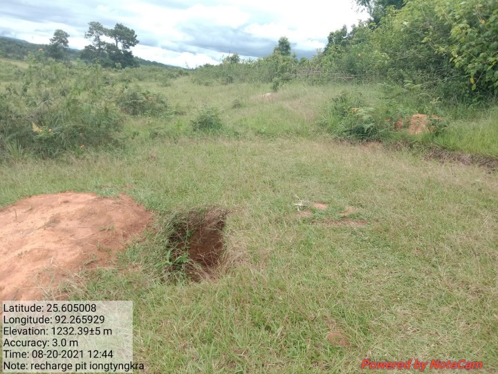
| 3 | Recharge Pit | Iong Tyngkra | Lt 25.608189 | L 92.27402 | Rs.22,914.00 | Implemented |
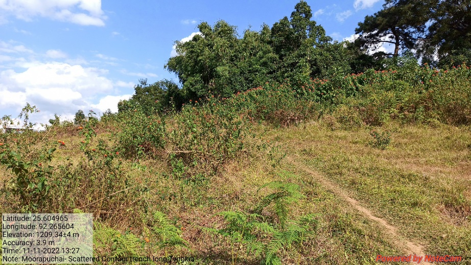
| 4 | Staggered Contour Trenches | Iong Tyngkra | Lt 25.608184 | L 92.274036 | Rs.7,800.00 | Implemented |
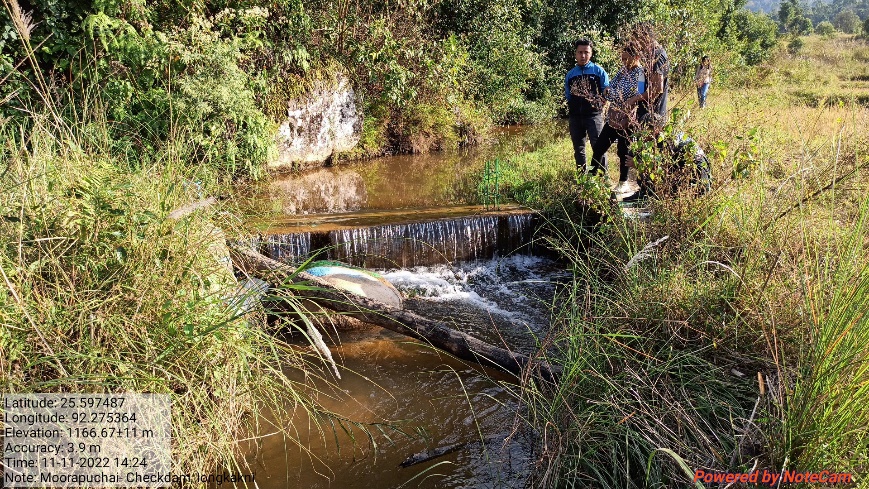
| 5 | Check Dam | Iongkakni | Lt 25.597533 | L 92.275386 | Rs.2,12,710.00 | Implemented |
| 6 | Check Dam | Moolong | Lt.25.595598 | L 92.273648 | Rs.2,15,300.00 | Implemented |
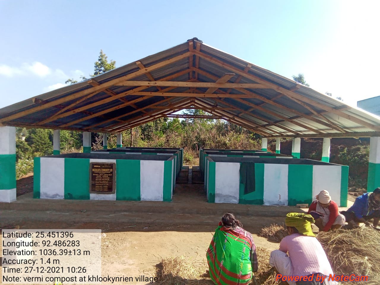
| 7 | Vermi composting | Poh kperkmai | Lt 25.611578 | L 92.277349 | Rs.3,01,619.00 | Implemented |
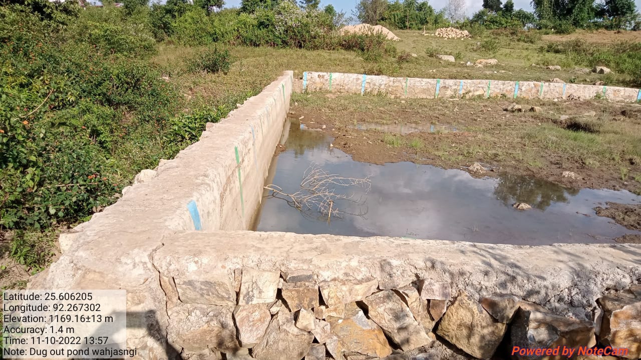
| 8 | Dug out pond cum fish & agri cultivation | Poh Wah iasngi | Lt 25.606235 | L 92.2675 | Rs.4,99,868.00 | Implemented |
| 9 | RCC Check Dam | Iong tyngkra | Rs.3,29,719.00 | Implemented | ||
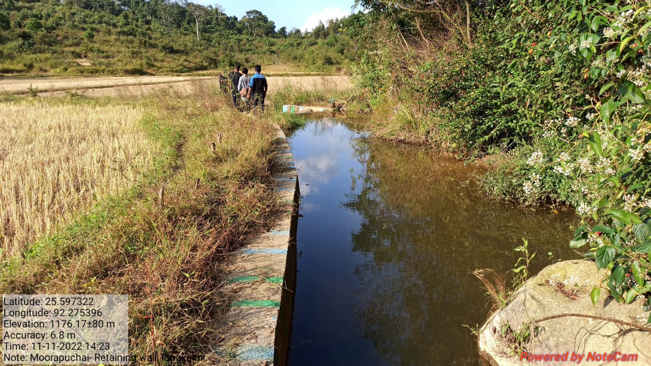
| 10 | RR Protection Wall | Iongkakni | Lt 25.597322 | L 92.275396 | Rs.1,35,508.00 | Implemented |
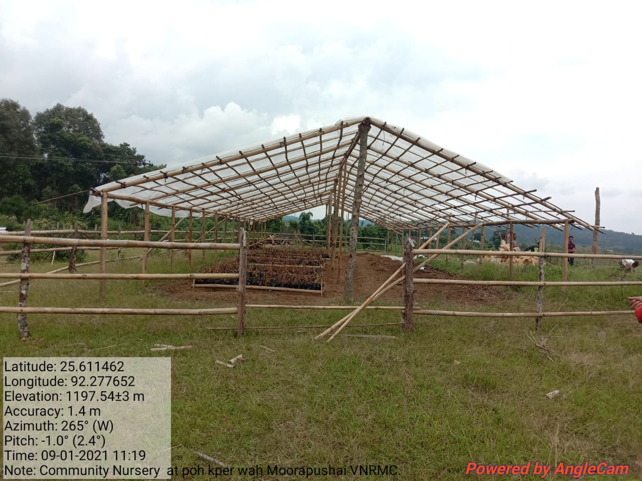
| 11 | Community Nursery | Poh Kperkmai | Lt 25.611462 | L 92.277652 | Rs.1,13,960.00 | Implemented |
| 12 | Afforestation | Mokyrdai Lum Nongsiang | Rs.1,30.960.00 | Implemented | ||
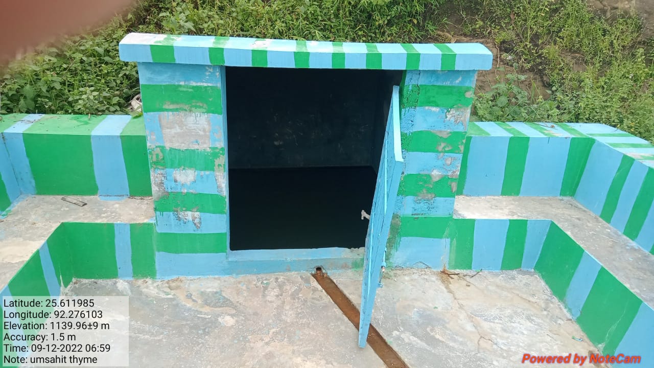
| 13 | Spring Chamber | Umsahit | Lt. 25.611985 | L 92.276103 | Rs.1,49,772.00 | Implemented |
| 14 | Spring Chamber cum Canal | Mukoi | Lt 25.608205 | L 92.27049 | Rs.1,30,960.00 | Implemented |
4. FUND STATUS
| SL NO | Type Of Intervention | Site Name | GPS Co-ordinates | Amount Estimate | Work Status |
|---|---|---|---|---|---|
| 1 | Vermi Composting | Poh kperkmai | Elevation: 1036.39+ 13m | Rs.3,01,619.00 | Implemented |
| SLNO | Type Of Intervention | Site Name | GPS Co-ordinates | Amount Estimate | Work Status |
|---|---|---|---|---|---|
| 2 | Community Nursery | Poh kperkmai | Elevation:1197.54+3m | Rs.1,13,960.00 | Implemented |
| SL NO | Type Of Intervention | Site Name | GPS Co-ordinates | Amount Estimate | Work Status |
|---|---|---|---|---|---|
| 3 | Spring Chamber | Umsahit | E 1139.96+9m | Rs.1,49,772.00 | Implemented |
| SL NO | Type Of Intervention | Site Name | GPS Co-ordinates | Amount Estimate | Work Status |
|---|---|---|---|---|---|
| 4 | Dug out Pond cum fish | Wah jasngi | Elevation: 1169.16+13m | Rs.4,99,868.00 | Implemented |
| SL NO | Type Of Intervention | Site Name | GPS Co-ordinates | Plan Estimate | Work Status |
|---|---|---|---|---|---|
| 5 | RR Protection wall | Iongkakni | Elevation: 1176.17+80m | Rs.1,35,508.00 | Implemented |
| SL NO | Type Of Intervention | Site Name | GPS Co-ordinates | Plan Estimate | Work Status |
|---|---|---|---|---|---|
| 6 | Staggered Contour Trenches | Iong Tyngkra | Elevation:1209.34+4m | Rs.7,800.00 | Implemented |
| SL NO | Type Of Intervention | Site Name | GPS Co-ordinates | Plan Estimate | Work Status |
|---|---|---|---|---|---|
| 7 | Recharge Pit | Umwah | Elevation:1232.39+5m | Rs.22,914.00 | Implemented |
| SL NO | Type Of Intervention | Site Name | GPS Co-ordinates | Plan Estimate | Work Status | |
|---|---|---|---|---|---|---|
| 8 | Check Dam | Iongkakni | Elevation:1166.67+11m | Rs.2,12,710.00 | Implemented |