Village Profile on
Mawblei Village under Mairang C&RD
Block
District: Eastern West Khasi Hills District
3rd March, 2021.
COMMUNITY LED LANDSCAPE MANAGEMENT
PROJECT
(CLLMP)


The Government of Meghalaya with financial help from the World Bank is implementing the Meghalaya Community Led Landscape Management Project (MCLLMP). The project will cover the entire state of Meghalaya and implementation of community led plans will be rolled out in phase manner throughout the state. The Meghalaya Basin Management Agency (MBMA) will facilitate community-led planning by providing support, technical inputs, and funding.
The project is intended to strengthen community-led natural resources management in selected landscapes within the 11 districts of the state. This would be achieved through a variety of planning, capacity building, and on-the-ground interventions to promote the conservation, sustainable use of natural resources, social inclusion, and community mobilization; building traditional knowledge and learning, mapping of natural resources management; strengthening the community institutions and creating linkage with financial institutions and community organizations.
The project interventions will include preparation of community led natural resource management plans. The CLLMP has the following three components:
Strengthening Knowledge and Capacity of Communities for NaturalResources Management.
Community-Led Landscape Planning and Implementation.
Project Management and Governance.
Objectives:
The project objective is “to manage and conserve the natural resources, especially forests, soil and water sources, in a manner that supports the financial and physical well-being of communities in the State”.
The CLLM-Programme focuses on increasing the capacities of communities and traditional institutions (TI) by adopting a landscape approach to manage their natural resources such as soil, springs and other water sources, forests and bio-diversity, etc.
The project will be planned and implemented in about 400 villages across the state.
CLLMP has a strong focus on institution-building at the village-level, by ensuring systematic capacity-building on technical and social skill-sets.
The project will also extend such training to communities beyond the targeted villages and support efforts made by them to access funding from various rural and natural resources initiatives and schemes.
The Programme will also invest in improving the process and outcome delivery, by developing and adhering to effective systems and procedures, supported by the appropriate technology.
Benefits for community (Skills and Capacity relating to technical and managerial areas like NRM and Conflict resolution
Benefits to traditional institutions (village councils, traditional leaders, community-based organizations, SHGs etc) through Knowledge sharing, promotion of innovative approach, access to technology, technical managerial and financial support.
It is estimated that the project will impact around 1 lakh partners (of which 50% are women) who depend on land, forest, agro forestry.
Through the project, 55000 Ha of targeted area will be ensured with availability of water, biological resources and soil productivity, which will in turn benefit around 400 villages and the outcomes delivery can be summarized as follows.
The Project will be executed by the MBMA in collaboration with other partners particularly, SIRD (for training and capacity building), Department of Soil and Water Conservation, Water Resource Department, Forest Department, specifically with respect to technical inputs, safeguards management and Community NRM plan preparation.
2018-2023 (5 years).
| Sl. No. | Topics | Page No. |
|---|---|---|
| I. | Introduction & History | 5-6 |
| II. | Social Profile | 7 |
|
7-9 | |
| III. | CLLMP Activities | 8 |
|
8-22 |
I.Introduction:
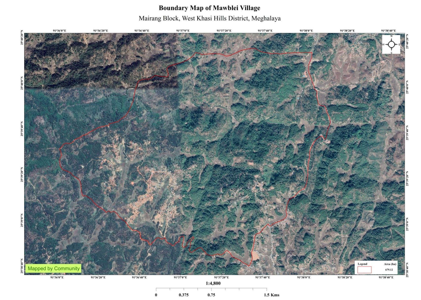 Mawblei Village is situated in Eastern
West Khasi hills District under Mairang C&RD Block at 18kms away
from the District Headquarter, Mairang, and 71kms from Nongstoin,
West Khasi Hills District. The geographical area of Mawblei village
is 678.17ha and a total population of 2014 villagers from 350
household.
Mawblei Village is situated in Eastern
West Khasi hills District under Mairang C&RD Block at 18kms away
from the District Headquarter, Mairang, and 71kms from Nongstoin,
West Khasi Hills District. The geographical area of Mawblei village
is 678.17ha and a total population of 2014 villagers from 350
household.
.
Mawblei village is part of the Hima Nongkhlaw. Mawblei village was established about 100 years ago before the ruling of Syiem Tirot Sing of Hima Nongkhlaw. The first people who resided at Mawblei village belonged to the Nongrang Clan till recently known as ‘Siejkrai’ and after them another clan resided till recently known as ‘Mawsithew.’ It was during this period that the number of houses increased and Shri. L. Monsing was elected as the Headman.
During this period, the so called ‘Niam Khasi’ was highly believed; the practice remained deeply in the village till the arrival of Christianity. The villagers celebrated their rituals on a large stone at the edge of the village. Until recently, this stone was commonly called as ‘U Mawblei’ where the village gets its name from. Mawblei is well recognised in Eastern West Khasi Hills District as well as by the Government of Meghalaya for its developmental activities.
Lately, the village grew and prospered. However, there remains monuments and relics of the past in the village that are still considered sacred today.


1.Ground Truthing:
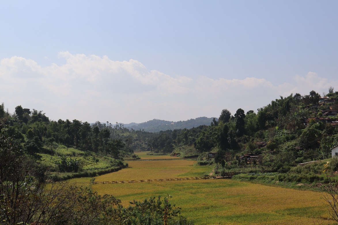
The DPMU-CLLMP team conducted the first visit to the village of Mawblei on 23rd Feb, 2019. The DPMU-CLLMP met with Shri H. H. June Mairang, Headman of Mawblei village and other village representatives for field assessment. Shri. H. H. June Mairang provided the team with important information regarding the current scenario of the landscape and the natural resource management under his Headmanship in the village. They found that there was availability of degraded land which were mostly fallow and barren and some eroded areas. The village mostly depended on springs for drinking water and streams for other domestic purposes. The soil type in the village was sandy loamy and reddish brown.
Case finding:
There are a total number of 350 households.
Actively performing VEC.
Forest on hills slopes is prone to forest fires. Loss of natural vegetation.
Lack of water resources.
The village have access to drinking water.
Few patches of degraded land have been left unused.
There are 5 Schools in the Village i.e., Primary Schools.
2. Sensitization Programme:
The first sensitization programme of Mawblei village was conducted on the on the 22nd March, 2019, by the District Project Manager and the Assistant Manager on the Community Led Landscape Management Project. The DPMU team gave a detailed presentation on CLLMP as well as the guidelines related to the Project. Villagers who participated in the programme voiced out their concerns and questions regarding the project making it a huge success.
Highlights of the meeting:
Awareness about Community–Landscape Management project.
Laying importance on the involvement of the community in making the CNRM plan and its success.
A brief awareness on cleanliness was conducted based on our findings during the ground truthing phase.
An interactive session was held to answer the doubts of the villagers regarding the project.
2.1. Signing of EOI, VGA and Green Charter:
Mawblei Village signed the Expression of Interest (EOI), the Village Grant Agreement (VGA) and the Green Charter on the 30th August, 2019, after a uniform agreement by the enitre community that the Community-Led landscape Management Project (CLLMP) be implemented at Mawblei Village.
2.2 Formation of the VNRMC:
The Formation of the Village Natural Resource Management Committee was done on the 13th June, 2019, in a public meeting in the presence of the entire village and the CLLMP team. The community chose the President, the Secretary, and other executive members of the committee.
Listed below are the members of the VNRMC:
| Village Natural Resource Management Committee (9-member committee constituted from Village Council, SHG group, Women’s group, youth, VEC) | ||||||||
|---|---|---|---|---|---|---|---|---|
| Sl. No. | Name in Full | Gender M/F | Age (in Yrs) | Education | Designation | Occupation | Community | Contact No |
| 1 | H. H. June Mairang | Male | 48 | X | President | Teacher | Khasi | 7085361706 |
| 2 | K. Ryntathiang | Female | 50 | BA | Secretary | Teacher | Khasi | 8837297614 |
| 3 | Andreas Ryntathiang | Male | 24 | XII | Finance Secretary | Student | Khasi | 9383284625 |
| 4 | C. Ryntathiang | Male | 40 | X | Member | Carpenter | Khasi | 8787653509 |
| 5 | R. Ryntathiang | Male | 30 | XII | Member | Labourer | Khasi | 9383284907 |
| 6 | Mardrane | Female | 36 | VIII | Member | Farmer | Khasi | 8974736452 |
| 7 | S. Ryntathiang | Male | 45 | X | Member | Teacher | Khasi | NA |
| 8 | S. Nongsiej | Male | 36 | IX | Member | Farmer | Khasi | 9366161358 |
| 9 | B. Ryntathiang | Male | 47 | IX | Member | Farmer | Khasi | 9383284907 |
3.Opening of Bank Account:
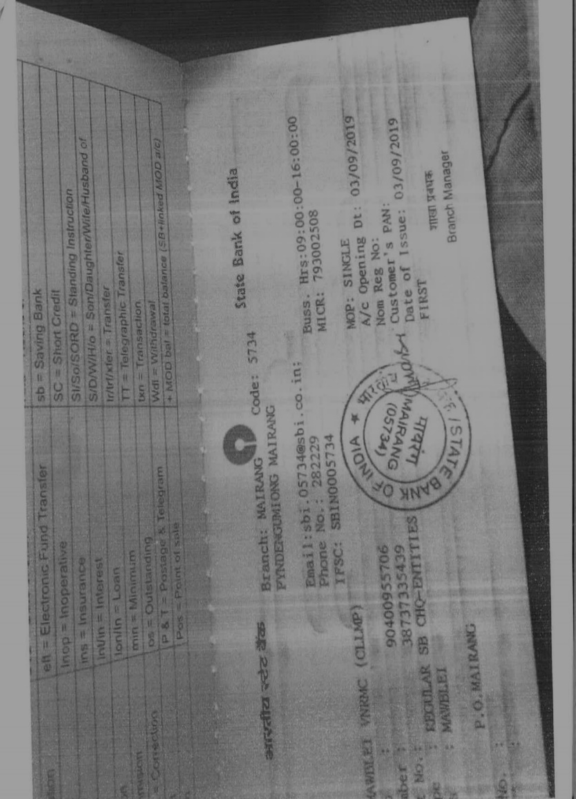 The
opening of the bank account in Mawbei village was done after the
signing of the EOI (Expression of Interest), the VGA (Village Grant
Agreement) and the signing of the Green Charter at the respective
villages. A meeting was held for all the VNRMC members of Mawblei to
brief and assist them before opening the VRNMC bank account. The
bank account was opened on 3rd September 2019.
The
opening of the bank account in Mawbei village was done after the
signing of the EOI (Expression of Interest), the VGA (Village Grant
Agreement) and the signing of the Green Charter at the respective
villages. A meeting was held for all the VNRMC members of Mawblei to
brief and assist them before opening the VRNMC bank account. The
bank account was opened on 3rd September 2019.
4. Participatory Rural Appraisal Exercise (PRA):
The PRA exercise aims to incorporate the knowledge and opinions of the community in the planning and management of development projects and programmes. The PRA exercise at Mawblei village took place, where a total of 35 villagers, men and women included, took part in the exercise.
The initial stage of the Participatory Rural Appraisal (PRA) exercise at Mawblei village commenced with a meeting cum orientation program on CLLMP. While conducting the meeting, the community members were made aware of the various PRA exercises conducted for the development of the Community Natural Resource Management Plan (CNRMP) of the village, the community members’ contribution in the exercise and the objectives to be achieved. The key informants, the VNRMC and the VCFs, helped facilitated the maximum participation.
Commencement of PRA:
Introduction: Participatory Rural Appraisal (PRA) is the process of involving local people in the analysis and interpretation of their own situation of a given rural area. The local people i.e., the participants take a leadership role in collecting, analyzing, interpreting and presenting information and in this process impart knowledge and development insight to the specialists and extension agents.
For management of natural resources, participatory Rural Appraisal is conducted to establish rapport with the village community as well as to identify and define problems for prioritization in the village itself. It is a way of learning from and with community members to investigate their need assessment, analyze and evaluate constraints and opportunities and find out priorities in the area of agriculture, small scale rural enterprises and any other social and economic development programs addressed to village development. Based on the principle of listening and learning.
Objectives of PRA exercise in Mawblei village:
The Participatory Rural Appraisal (PRA) exercise in Mawblei village was conducted with following objectives:
To identify the natural, human, and economic resources of village.
To identify the village problems and prioritize them with the help of the community members.
To prepare the Community natural Resource Management Plan of the village.
Activity 1: Village Boundary Mapping and Resource Mapping:
The GIS in collaboration with the Village Community Facilitators mapped the village boundary of Mawblei Village and to involve the local community in preparation of village resource map as perceived by the community members to solicit their participation. Infrastructure, services, and other village resources such as agricultural lands, wells, forest, wastelands, cattle population etc., were mapped. Local people prepared the Resource Map by drawing it on a chart paper as well as on the ground without much interference of outsiders.
This activity achieved the following purposes:
Rapport building and won the confidence of the villagers.
Analyzed the spatial information, particularly studied problems, and opportunities of villagers.
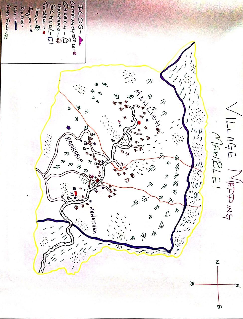 Got an impression about
the village setting, physical layout, location of various houses and
institution.
Got an impression about
the village setting, physical layout, location of various houses and
institution.
Findings Based on the Resource Map of Mawblei Village:
Main agriculture produce is Oranges.
There is only one types of Forest ownership i.e., Private Forest.
Presence of Community Hall.
Presence of Football playground.
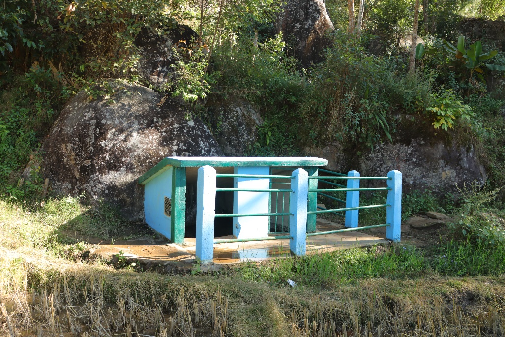
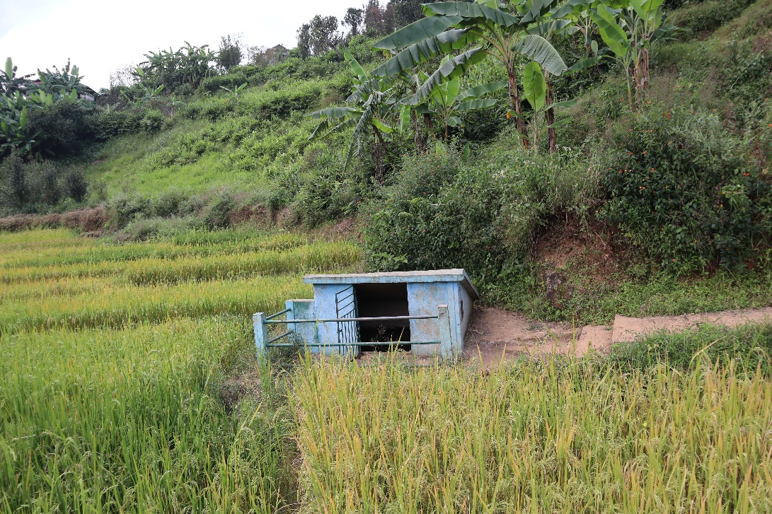
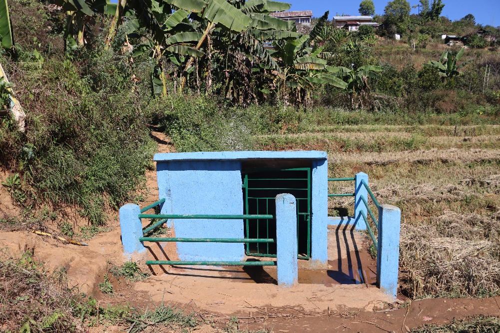
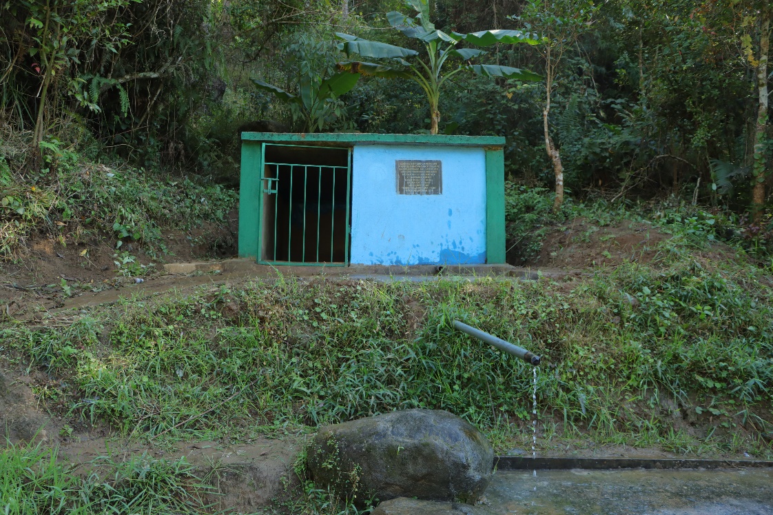
6 springs Chamber.
5 schools in Mawblei Village i.e., Primary Schools.
Activity 2: Basic Survey for CNRMP Template:
During the PRA exercise, the External Experts of Social & Environment Management held group discussions with different groups to gather basic village information regarding number of households, demographic information, major crops, and enterprises taken in the village, trends of production and productivity of major crops in the village and demographic distribution of village population.
Information related to land use category such as forest, cultivable land, water bodies, etc., and problems and challenges related to NRM were discussed.
Activity 3: Focussed Group Discussions:
Do people have sufficient access to supply of fodder, fuel wood, leaf litter?
Not sufficient.
Has access to timber improved or reduced over the years? How is access for household use and commercial use managed?
Reduced; bought from other villages.
Are the water bodies facing any threats?
Yes.
Do all people in the village have access to drinking water? What are the challenges?
Yes.
Are there degraded areas in the village (open/ degraded forests, mining affected, high soil erosion etc.)?
Yes, open, and degraded forest, high soil erosion.
What has caused this degradation? Are there practices causing threats to availability and access to natural resources?
Deforestation; Overextraction.
What have been the changes in agricultural practices?
Low productivity.
Are there any challenges in farming?
Yes, infestation.
How would you consider the health situation in your village?
Good.
How is the situation of cleanliness, sanitation, access to toilets and waste management?
Good.
Who are the most vulnerable in the village? What can be done to improve their lives?
Poor people.
Education and employment generation
What are the livelihood aspirations of the youth? Are there any avenues available?
Employment generation.
Do any committees/ institutions/ rules exist to manage and monitor natural resources in the village?
Village Natural Resource Management Committee.
What are some of the major issues of conflict in the village?
No major issues.
Have any of the above issues been discussed in village meetings?
Yes.
How do people resolve disagreements and conflicts?
Dorbar Shnong.
5. Submission of the CNRMP:
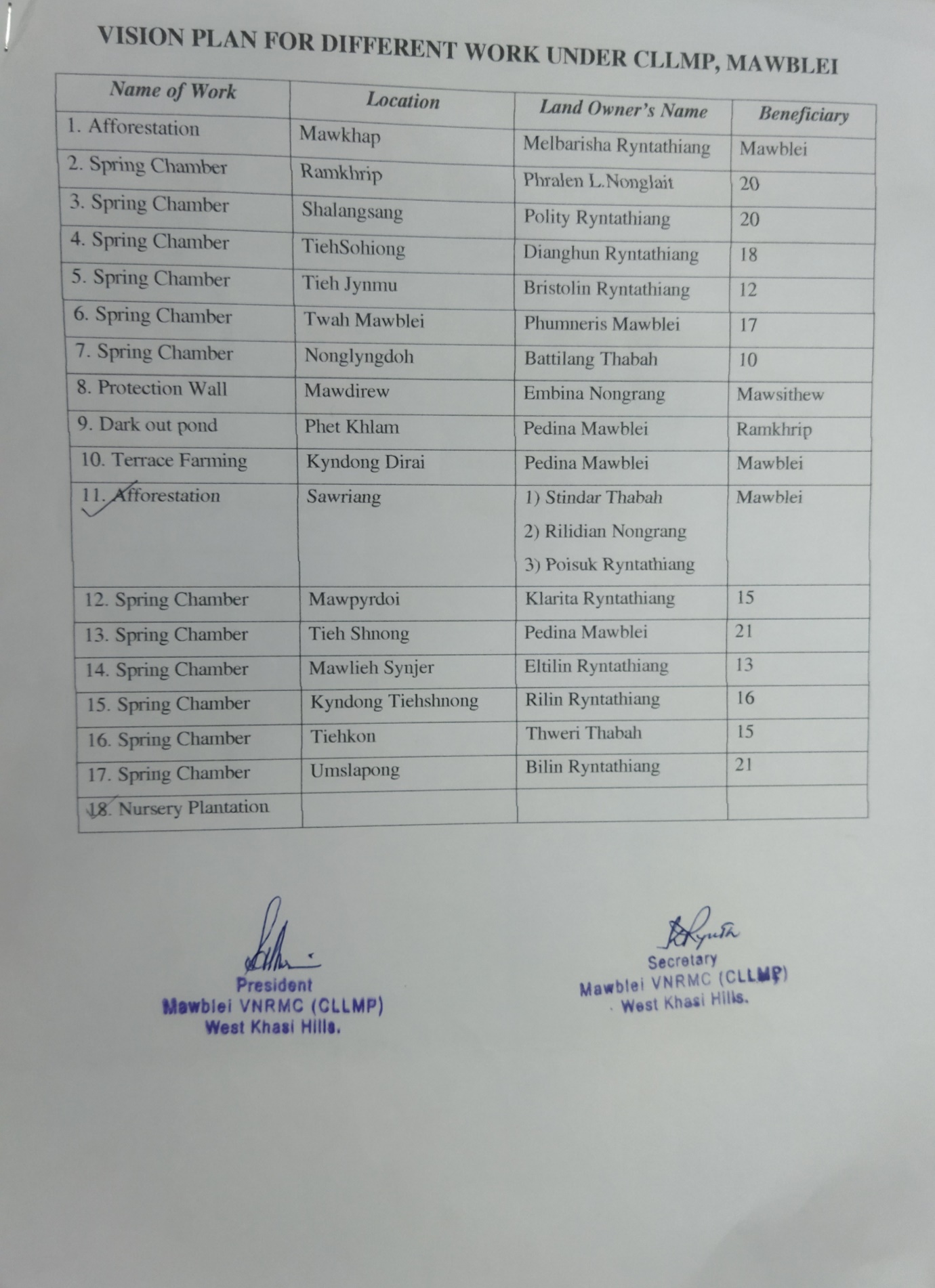
5.1 Final CNRMP Plan:
| SL.No | Name of work | Site | Land ownership | Benefited | Priority (High/Medium/Low) |
|---|---|---|---|---|---|
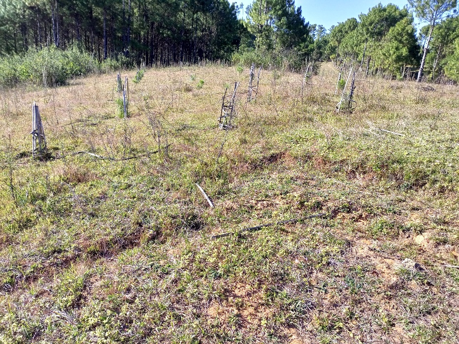
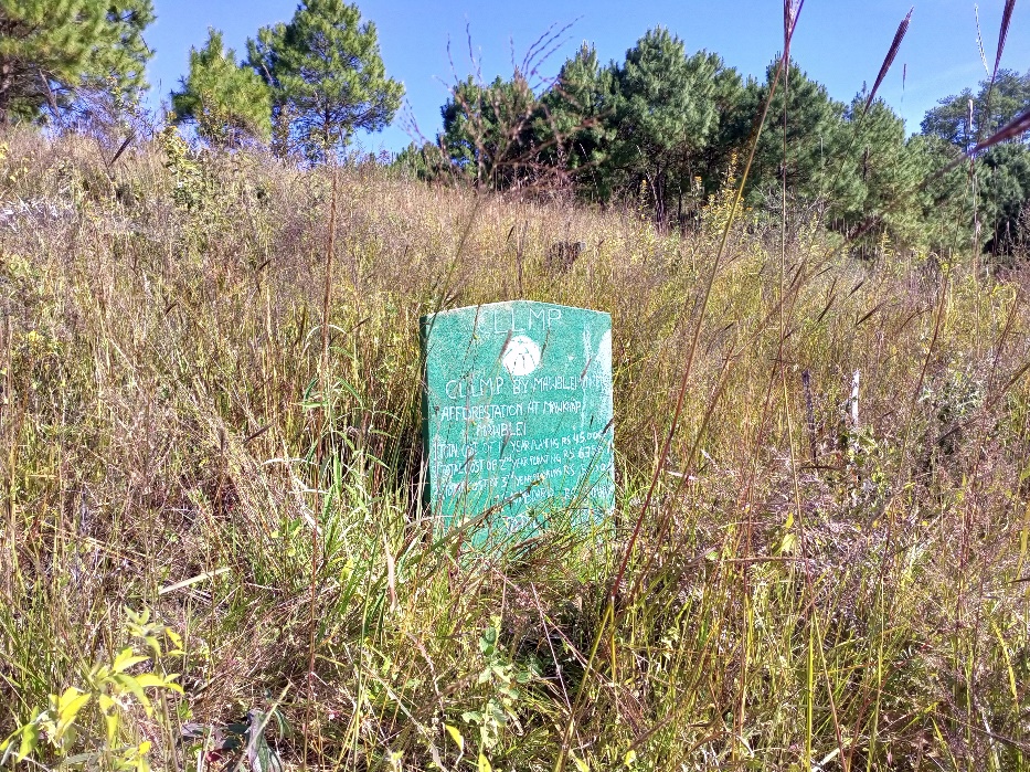
| 1 | Afforestation | Mawkhap | Private | Mawblei | High |
| 2 | Spring Chamber | Ramkhrip | Private | 20 | High |
| 3 | Spring Chamber | Shalangsang | Private | 20 | High |
| 4 | Spring Chamber | Tiehsohiong | Private | 18 | High |
| 5 | Spring Chamber | Tieh Jynmu | Private | 12 | High |
| 6 | Spring Chamber | Twah Mawblei | Private | 17 | High |
| 7 | Spring Chamber | Nong Lyngdoh | Private | 10 | High |
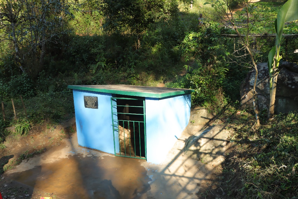
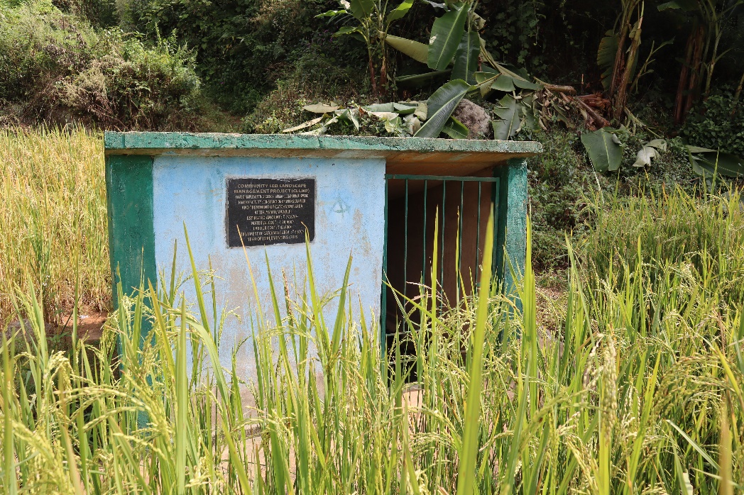
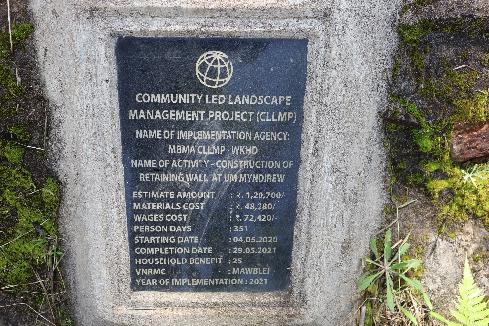
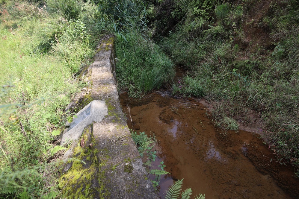
| 8 | Protection Wall | Mawdirew | Private | Mawsithew | High |
| 9 | Dugged Out Pond | Phet Khlam | Private | Ramkhrip | High |
| 10 | Terrace Farming | Kyndong Dirai | Private | Mawblei | High |
| 11 | Afforestation | Sawriang | Private | Mawblei | High |
| 12 | Spring Chamber | Mawpyrdoi | Private | 15 | High |
| 13 | Spring Chamber | Tieh Shnong | Private | 21 | High |
| 14 | Spring Chamber | Mawlieh Synjer | Private | 13 | High |
| 15 | Spring Chamber | Kyndong Tiehshnong | Private | 16 | High |
| 16 | Spring Chamber | Tieh Kon | Private | 15 | High |
| 17 | Spring Chamber | Umslapong | Private | 21 | High |
| 18 | Nursery Plantation |
6.Project Implementation:
| 1. | Type Of Intervention | Site Name | GPS Co-ordinates | Amount Sanctioned | Work Status | |
|---|---|---|---|---|---|---|
| Afforestation | Mawkhap | 25.671131 | 91.625876 | 59,750.00/- | Completed | |
| 2. | Type Of Intervention | Site Name | GPS Co-ordinates | Amount Sanctioned | Work Status | |
|---|---|---|---|---|---|---|
| SC & TCA | Shalangshan | 25.660138 | 91.605771 | 78,200.00/- | Completed | |
| 3. | Type Of Intervention | Site Name | GPS Co-ordinates | Amount Sanctioned | Work Status | |
|---|---|---|---|---|---|---|
| SC & TCA | Umshiong | 25.65549 | 91.61666667 | 78,200.00/- | Completed | |
| 4. | Type Of Intervention | Site Name | GPS Co-ordinates | Amount Sanctioned | Work Status | |
|---|---|---|---|---|---|---|
| SC & TCA | Ramkhrip | 25.65208139 | 91.61147972 | 64,000.00/- | Completed | |
| 5. | Type Of Intervention | Site Name | GPS Co-ordinates | Amount Sanctioned | Work Status | |
|---|---|---|---|---|---|---|
| SC & TCA( Afforestation) | Nonglyngdoh | 25.66001167 | 91.61073 | 77,864.00/- | Completed | |
| 7. | Type Of Intervention | Site Name | GPS Co-ordinates | Amount Sanctioned | Work Status | |
|---|---|---|---|---|---|---|
| SC & TCA( Afforestation) | TwahMawblei | 25.65722806 | 91.61107806 | 88,380.00/- | Completed | |
| 6. | Type Of Intervention | Site Name | GPS Co-ordinates | Amount Sanctioned | Work Status | |
|---|---|---|---|---|---|---|
| SC & TCA | Tihjynmu | 25.65387833 | 91.61169611 | 77,870.00/- | Completed | |
| 8. | Type Of Intervention | Site Name | GPS Co-ordinates | Amount Sanctioned | Work Status | |
|---|---|---|---|---|---|---|
| Retaining Wall | Ummyndierew | 25.64778667 | 91.61761972 | 120,700.00/- | Completed | |
| 9. | Type Of Intervention | Site Name | GPS Co-ordinates | Amount Sanctioned | Work Status | |
|---|---|---|---|---|---|---|
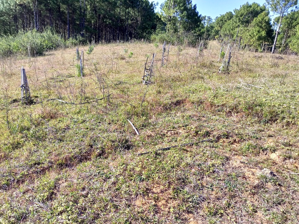
| Afforestation with Staggered Trenches | Sawriang | 25.670592 | 91.618463 | 100,000.00/- | Completed | |
Fund Status:
| Fund Released to VNRMC (Project Implementation) | Total No. of Work Order Issued | Total amount Issued under CLLMP (Per Activity) | Total Amount Spent | Start Date | End Date |
|---|---|---|---|---|---|
| ₹21,55,000/- | 9 | Afforestation At Mawkhap(59,750.00) | 48,000.00 | 06/07/2020 | 26/08/2020 |
| SC & TCA At Shalangshan(78,200.00) | 74,700.00 | 06/07/2020 | 06/10/2020 | ||
| SC & TCA At Umshiong(78,200.00) | 74,700.00 | 06/07/2020 | 06/10/2020 | ||
| SC & TCA At Ramkhrip(64,000.00) | 60,500.00 | 06/07/2020 | 06/10/2020 | ||
| SC & TCA At Nonglyngdoh: Afforestation/Spring Chamber (77,864.00) | 77,864.00 | 26/11/2020 | 18/01/2021 | ||
| SC & TCA At Tihjynmu: Afforestation/Springchamber (77,870.00) | 77,870.00 | 26/11/2020 | 18/01/2021 | ||
| SC & TCA At Twahmawblei: Afforestation/Springchamber (88,380.00) | 88,380.00 | 02/12/2020 | 18/01/2021 | ||
| Retaining Wall at Um Myndierew (120,700.00) | 120,700.00 | 04/05/2021 | 26/07/2021 | ||
| Affotestation at Sawriang (100,000.00) | 73,170.00 | 27/07/2021 | 16/08/2021 | ||
| TOTAL AMOUNT SPENT | 695,884.00/- | ||||