Village Profile on
Mawruksoin village under Mawshynrut C&RD block
West Khasi Hills District
COMMUNITY LED LANDSCAPE MANAGEMENT PROJECT
CLLMP

Report on
MAWRUKSOIN VILLAGE
MAWSHYNRUT C&RD BLOCK
District:SOUTH WEST KHASI HILLS DISTRICT
24TH August, 2020
COMMUNITY LED LANDSCAPE MANAGEMENT PROJECT
MEGHALAYA BASIN MANAGEMENT AGENCY
COMMUNITY LED LANDSCAPE MANAGEMENT PROJECT (CLLMP)
The Government of Meghalaya with financial help from the World Bank is implementing the Meghalaya Community Led Landscape Management Project (MCLLMP). The project covers the entire state of Meghalaya, and implementation of community-led plans are rolled out in a phased manner throughout the state. The Meghalaya Basin Management Agency (MBMA) will facilitate community-led planning by providing support, technical inputs, and funding.
The project is intended to strengthen community- led natural resources management in selected landscapes within the 7 districts of the state. This would be achieved through a variety of planning,
The Government of Meghalaya with financial help from the world Bank is implementing the Meghalaya community Led Landscape Management Project (MCLLMP). The Project will cover the entire State of Meghalaya and implementation of community led plans will be rolled out in phase manner throughout the State. The Meghalaya Basin Management Agency will facilitate community led planning by providing support, technical inputs and funding.
The project is intended to strengthen community led natural resources management in selected landscape within the 11 Districts of the state .This would be achieved through a variety of planning, capacity building, and on-the-ground interventions to promote the conservation, sustainable use of natural resources, social inclusion, community mobilization; building traditional knowledge and learning, mapping of natural resources management; strengthening the community institutions and creating linkage with financial institutions and community organizations.
The project interventions will include preparation of community led natural resource management plans. The CLLMP has the following three components:
Strengthening Knowledge and Capacity of Communities for Natural Resources Management
Community-Led Landscape Planning and Implementation
Project Management and Governance.
Objective:
 The
project objective is “to manage and conserve the natural
resources, especially forests, soil and water sources, in a manner
that supports the financial and physical well-being of communities
in the State”
The
project objective is “to manage and conserve the natural
resources, especially forests, soil and water sources, in a manner
that supports the financial and physical well-being of communities
in the State”
The CLLMP- Programme focuses on increasing the capacities of communities and traditional institutions by adopting a landscape approach to manage their natural resources such as soil, Springs and other water resources forest and bio-diversity etc.
The Project will be planned and implemented in about400 villages across the State
CLLMP has a strong focus on institution building at the village level, by ensuring systematic capacity building on technical and social skill sets
The project also extends such training to communities beyond the targeted villages and support efforts made by them to access funding from various rural and natural resources initiatives and schemes.
The Programme will also invest in improving the process and outcome delivery, by developing adhering to effective systems and procedures, supported by the appropriate technology.
Benefits:
Benefits for community (skills and capacity relating to technical and managerial areas like NRM and conflict resolution
Benefits to traditional institutions (village councils, traditional leaders, community- based organizations, SHGs etc.) through knowledge sharing, promotion of innovative approach, access to technology, technical managerial and financial support.
It is estimated that the project will impact around 1 lakh partners (of which 50% are women) who depend on land, forest, Agro-forestry.
Through the project, 55000 Ha of targeted area will be ensured with availability of water, biological resources, and soil productivity, which will in turn benefit around 400 villages and the outcomes delivery can summarized as follows.
Benefits for community (Skills and Capacity relating to technical and managerial areas like NRM and Conflict resolution
Benefits to traditional institutions (village councils, traditional leaders, community-based organizations, SHGs etc) through Knowledge sharing, promotion of innovative approach, access to technology, technical managerial and financial support.
It is estimated that the project will impact around 1 lakh partners (of which 50% are women) who depend on land, forest, agro forestry.
Through the project, 55000 Ha of targeted area will be ensured with availability of water, biological resources and soil productivity, which will in turn benefit around 400 villages and the outcomes delivery can be summarized as follows.
The Project will be executed by the MBMA in collaboration with other partners particularly, SIRD (for training and capacity building), Department of Soil and Water Conservation, Water Resource Department, Forest Department, specifically with respect to technical inputs, safeguards management and Community NRM plan preparation.
2018-2023 (5 years)
Contents
| Sl. No. | Topics | Page No. |
|---|---|---|
| I. | Introduction & History | 4 |
| II. | Social Profile | 5 |
|
6-8 | |
| III. | CLLMP Activities | 9-45 |
|
I. INTRODUCTION
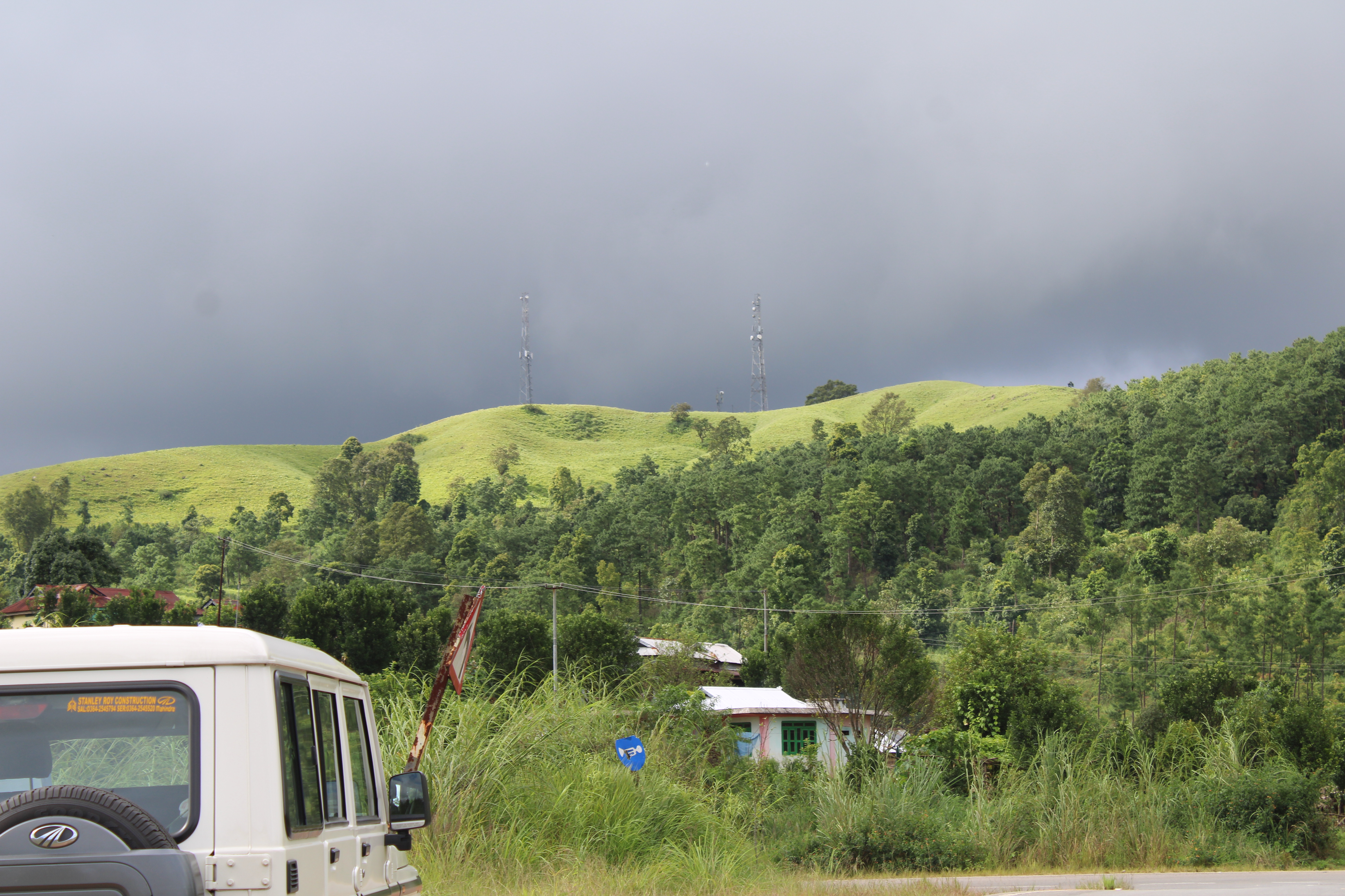
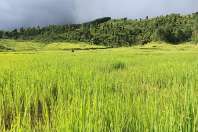
Mawruksoin Village falls under the Mawshynrut C&RD block of West Khasi Hills district in the state of Meghalaya. The distance of the village is 21 km from Nongstoin, the district headquarters of West Khasi Hills District and is at a total distance of 97 km from the state capital, Shillong. It falls under Hima Rambrai Jyrngam with a total geographical area of 146.47 ha and a total population of 275. There are various ways to reach to the village, with majority of the people relying on public busses and private cars to reach there on a sharing basis.
II.SOCIAL PROFILE
The Mawruksion village has a total number of 45 households with 275 population. out of this, 167 are males and 108 are females. The village has 46 children between the age group of 0-4 years. Among them 26 are boys and 20 are girls. Agriculture and allied activities are the main occupation of the people in the village.
Village Accessibility: Mawruksoin village is on the NH 44 E highway between Nongstoin and Riangdo. Different localities under the village are connnected through kuccha roads under the MGNREGA
Literacy: As per the 2011 census, the village literacy rate is 66%. Lower primary school is the only educational institution in Mawruksoin.
Presently the village is managed and guided by its active Dorbar as the highest authority in the village which is alternatively comprised of the Seng Kynthei, (Women Wing) Seng Samla (Youth Wing) and Village Defence Party (VDP) all collectively aiming for the overall good and growth of the village. Other committees such as Village Employment Council (VEC) and the Village Water and Sanitation Committee.
Population : Mawruksoin village has a total population of 275 villagers in the community. out of this 167 are males while the female count is 108. The village has 46 children between the age group of 0-4 years. Among them 26 are boys and 20 are girls.
| Age group | Male | Female | Total |
|---|---|---|---|
| 0-4 | 26 | 20 | 46 |
| 5-14 | 47 | 32 | 79 |
| 15-30 | 75 | 25 | 100 |
| 30-60 | 19 | 29 | 48 |
| Above 60 | 0 | 2 | 2 |
Population: Most of the villagers engaged themselves in agriculture for their livelihood and very less in teaching and other services.
BPL/APL Household:
| Particulars | No. of HH |
|---|---|
| BPL HH | 45 |
| APL HH | 0 |
Fuel Type:
| Fuel Type | Total HH |
|---|---|
| Charcoal | 0 |
| Biomass | 0 |
| Wood | 45 |
| LPG | 0 |
| Electric Heater | 0 |
| Kerosene | 0 |
 Key
constraints: There is scarcity of water in the village
and the villagers depend on springs for drinking and other domestic
activities.
Key
constraints: There is scarcity of water in the village
and the villagers depend on springs for drinking and other domestic
activities.
Water bodies: The village has a total number of 4 springs, 6 streams and 3 rivers.
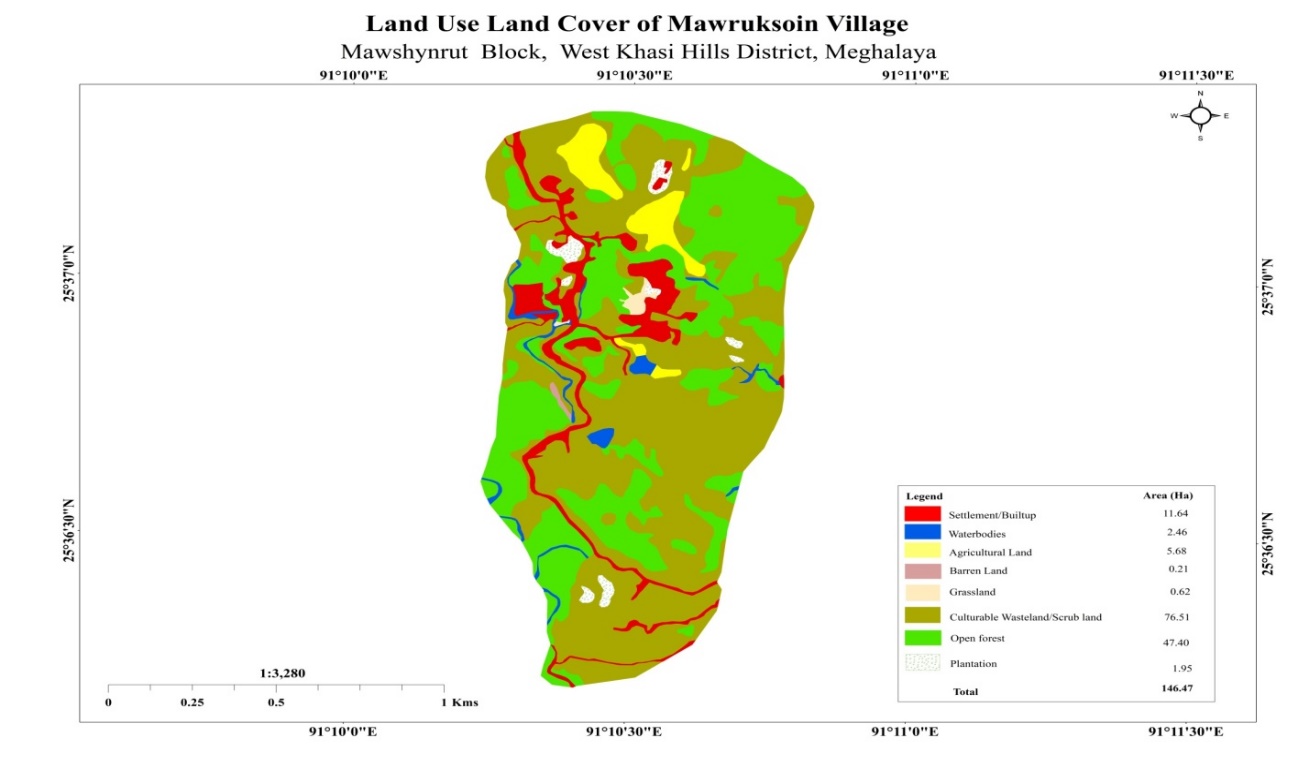
Forest: The village has a total forest cover of about 47.40 Ha and cultivatable land of 76.51 Ha.
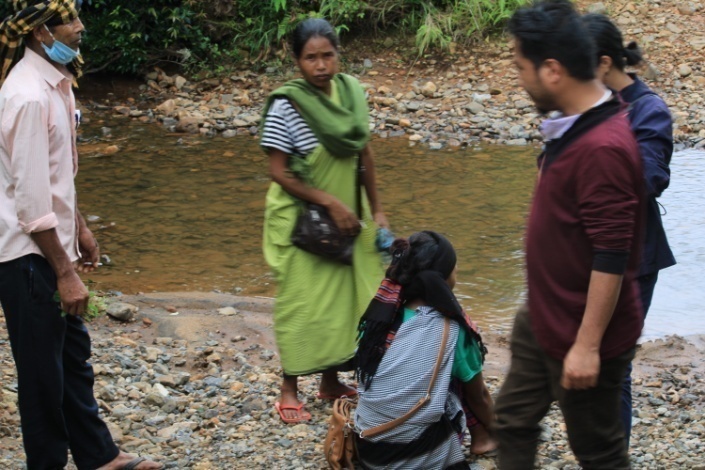
The district project management unit (DPMU) of SWKH met with Mr. Preciousking Lyngdoh, the Sordar of Mawruksoin Village, on the14th August, 2020 for Ground Truthing. He informed the team regarding the current scenario of the landscape and the natural resource management under his sordarship.
Case Findings:
The village has more than 40 HH.
It has an actively performing VEC.
There is no proper access to drinking water. They are mostly dependent on the four springs for drinking water for the whole village.
The village has a huge area of barren land.
The village has an outstanding number of orange trees with their own method of growing them.
There are also a number of local tree species that have yet to be identified.
There are a number of small streams which can be tapped for irrigational purposes and domestic use.
List of Natural Resources at Mawruksoin Village
A huge number of Orange trees.
Creeper plants such as cucumber, squash.
Tapioca, chilli, tomato, pumpkin, green vegetables, yam, ginger.
Rice, corn, millets,silkworm (seasonal).
Pond, stream and rivers.
Rationale for selection of village: The village was selected based on the above findings during GTS. Through the village has only 45 HH, it is on of the villages that is very active in the implementation of Govt Schemes and projects especially the MGNREGA.The village was also recommended by the BDO and APO, Mawshynrut C & RD Block as it is applicable to be included into the CLLMP.
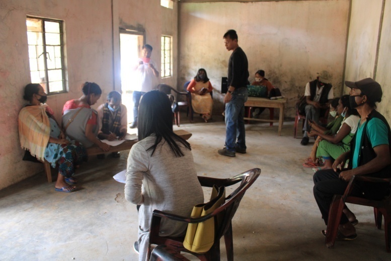
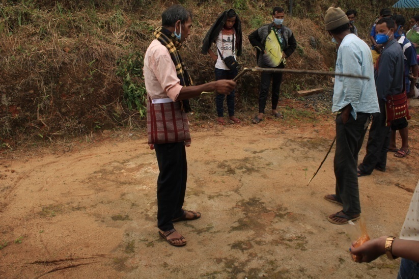
The sensitization programme took place on the 17th August, 2020 at the Community Hall of Mawruksoin Village. The sordar of Mawruksoin Village, Mr. Preciousking Lyngdoh, presided over the programme. Around 30 community members attended the sensitization program, where a significant number of the attendees were women.
The Assistant Manager (Social Management), Ms Ibanridashisha Kharkongor gave a brief introduction on Meghalaya Basin Management Agency (MBMA) and elucidated about the various programmes and projects that MBMA is working on, but mainly focused on the Community Led Landscape Management Project (CLLMP). She also spoke about the different aspects and procedures of the project and gave due importance on the objectives of the project and its benefits.
The DPM-CLLMP, SWKH Shri.John Kearney Wanniang gave a detailed presentation on the Community Led Landscape Management Project by giving numerous examples. He also enlightened the various benefits that the community could obtain from the project.
A presentation by Shri. Bansuk syiem ( AM-KM) on the identification, significance of Traditional knowledge and an in-depth explanation on the Innovation Fund was give on the same day.
The Asst Manager (Environment Management) Miss. Niwancy Bareh gave a brief presentation on the types of activities that may be taken up under CLLMP and other Environment related aspects. The GIS-CLLMP, SWKH gave a brief explanation on GPS and GIS mapping.
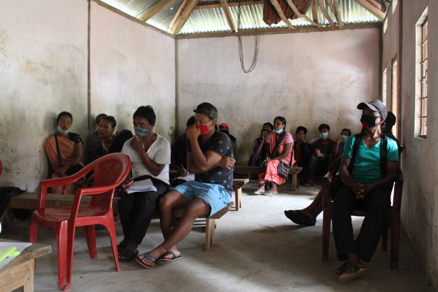
The Program was followed by an interactive session to answer the doubts and questions of the villagers. The following were the questions raised:
Can interventions be taken up in individually own land?
Ans: Interventions can be taken up in individual land provided NOCs and other agreements are duly signed and submitted to the DPMU.
Will the office claim the land taken up under intervention after intervention?
And: No
Who can apply for the Innovation Fund?
Ans: The Fund can be applied by individuals, groups, SHGs, Societies, Shcools, colleges, Villages, Committees etc.
Observations: The following are some of the observations made by the DPMU during the Sensitization Programme:
The number of people present during the programme was limited as the community has to follow protocols as given by district administration in relation to the COVID -19 pandemic.
The Community seemed confused especially with the different and complex procedure of CLLMP implementation and the air of confusion does not seem to clear even after the end of the programme. The reason for this as per interaction with the people after the programme is because they are more used to learning through experience rather than cramping information through direct instruction. The people however easily understood the need for formation of the VNRMC, the need for proper planning and the opening of the bank account.
Signing of EOI, VGA and GREEN CHARTER:
After the interactive session, the village signed the EOI, VGA and Green charter followed by the selection of candidates for the Village Natural Resource Management Committee. The Village Executive Committee (VEC) and the entire community carried out the procedure and elected the members of the VNRMC on the same day.
2.3 Formation of the VNRMC
The Formation of the Mawruksoin Village Natural Resource Management Committe was done in a public meeting in the presence of the entire village and the CLLMP staffs. The community itself chose the President, the Secretary and the other executive members of the Committee.
| Village Natural Resource Management Committee (9member committee constituted from Village Council and VEC, SHG group, Women’s group, youth;4 members should be women) | ||||||||
| Sl No | Name in Full | Gender M/F | Age (in Yrs) | Education | Designation | Occupation | Community | Contact No and email address |
| 1 | Freshotsking L. Marshillong | M | 62 | VIII | President | Farmer | Khasi | 8787837982 |
| 2 | MisildaLangrin | F | 27 | V | Secretary | Farmer | Khasi | 9383287227 |
| 3 | DivilianNongphud | F | 35 | VI | Finance Secretary | Farmer | Khasi | 8119095223 |
| 4 | Lina Nongphud | F | 58 | IV | Member | Farmer | Khasi | 9612798358 |
| 5 | WallamlyntiMarthong | F | 32 | V | Member | Farmer | Khasi | 8414937790 |
| 6 | TherinaK.Dewsaw | F | 58 | II | Member | Farmer | Khasi | 8132018204 |
| 7 | TaialinMawlieh | F | 30 | III | Member | Farmer | Khasi | 9612936718 |
| 8 | PharlyNongphud | M | 50 | V | Member | Farmer | Khasi | 8730085129 |
| 9 | KwiklyMawlieh | M | 42 | II | Member | Farmer | Khasi | 6009633874 |
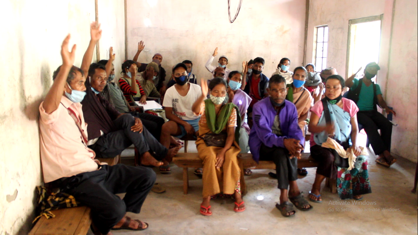
Fig:1 VNRMC Members
Village Community Facilitators
| Sl No | Name in Full | Gender M/F | Age (Yrs) |
Education | Role | Contact No and email address |
|---|---|---|---|---|---|---|
| 1 | PhingstromwellNongphud | Male | 36 | VIII | M&E project management | 9383329206 |
| 2 | LilishaL.Marshillong | Female | 23 | VII | SM&KM | 9862176432 |
| 3 | OrestarNongsiej | Male | 31 | IX | EVT &GIS | 9383296187 |
The opening of the bank account was initiated after the village signed the EOI (Expression of Interest), the VGA (Village Grant Agreement) and the Green Charter.
The process for the opening of the Bank account was done under the guidance of Shri. Nathaniel Kharkongor ( PA P & F). The bank account was opened on -----------------------The following were the steps taken:
The PA P & F first instructed the President to open a separate bank account to be used exclusively for the CLLMP and is not to be used for any other project or personal uses.
The President and Secretary are to be the authorized designated operators for the account.
Account may be opened at any bank to which the VNRMC selected the Seinduli MRB. This step is to be taken only after resolution has ben taken from the VNRMC.
A letter from the DPM enclosed with the letter for opening of accounts by VNRMCs was forwarded to the Seinduli MRB prior to account opening.
The VNRMC is to submit a copy of the passbook along with the resolution for opening of bank account by the VNRMC with recommendation letter as to the selection of the Bookeeper.
A forwarding letter from the president is also required for the release of funds for CNRMP preparation and implementation.
Rationale: Though the people were not entirely clear with the different process of CLLMP implementation, they however easily grasp the need for formation of the VNRMC. The requirement for the opening of the bank account is also easily understood by the people.
The proposal for the list of members to the VNRMC is done solely by the village whereby names of the members were given to the village to vote. The DPMU merely facilitates the process to ascertain that all groups has a say on the matter.
The documents (EOI, Geen Charter and VGA) were signed by the village after proper discussion and clarification was given.
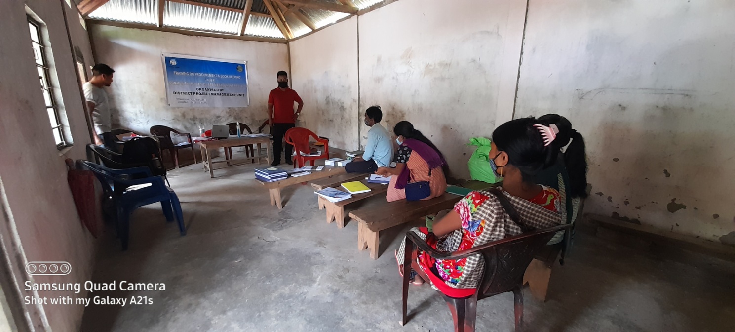
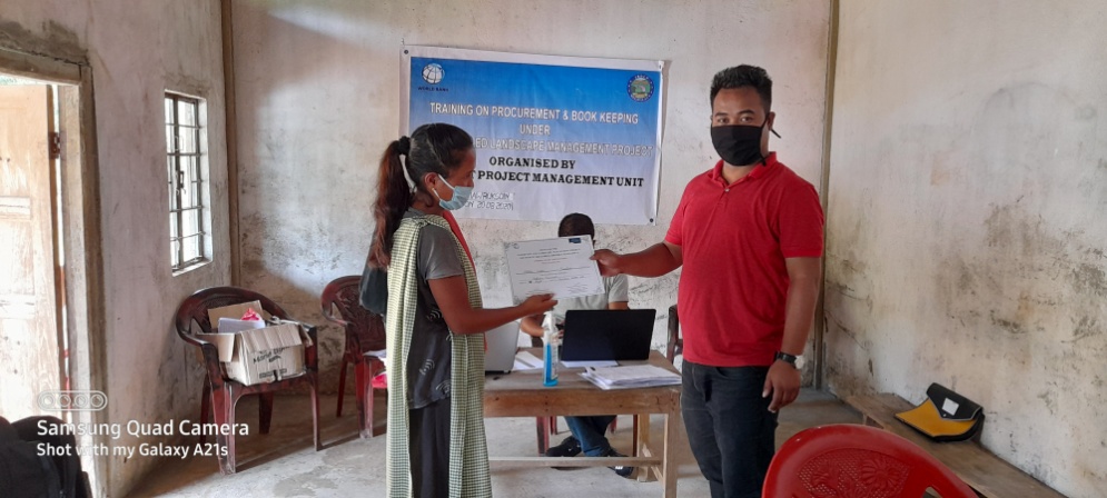
Training on Bookeeping & Soft Skills Distribution of Training Certificates
The PA P & F, DPMU SWKH District trained the Purchasing and Procurement Committee of Mawruksoin VNRMC on the 18th August, 2020.
Topics Covered:
Principles of Community Procurement
Benefits of Community Procurement
Important aspects undertaken by Community Procurement.
Procurement Process/Steps
Function of Purchase Committee
Important Procurement records to be maintained
Financial limits and methods
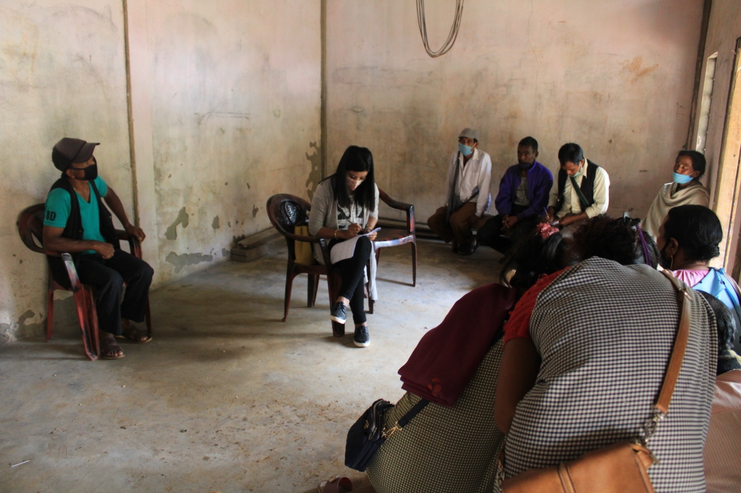
The Community Natural Resource Management Plan was prepared at a village level from the 18th – 25th August, 2020. Members of the community, including members of the Village Natural Resource Management Committee (VNRMC) were present to voice their problems and opinion while preparing the Community Natural Resource Management Plan.
The CNRMP process includes the collection of information from the community which is to be filled in the templates as given under the project. In this exercise, the information is directly collected from the people through direct question and answer method, group discussions and professional consultation (Asha, anganwadi, enumerators for more specific information).
4.Participatory Rural Appraisal:
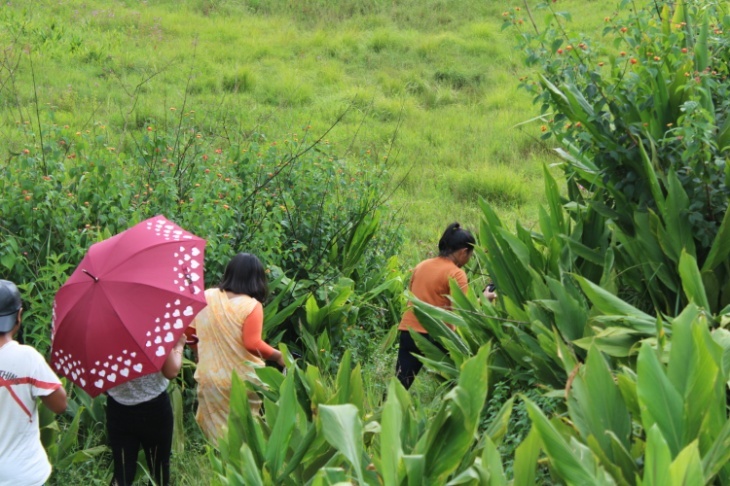
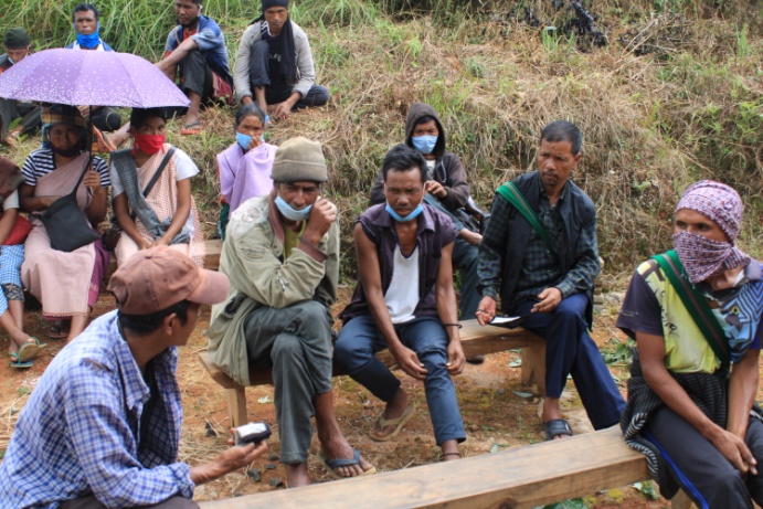
Introduction: The PRA exercise aims to incorporate the knowledge and opinions of the community in the planning and management of development projects and programmes. PRA exercise at Mawruksoin Village took place on the 18th August, 2020. There was a total of 29 villagers who took part in this exercise who contributed their time and knowledge to this project.
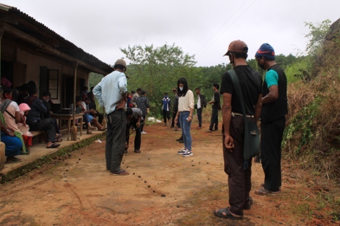
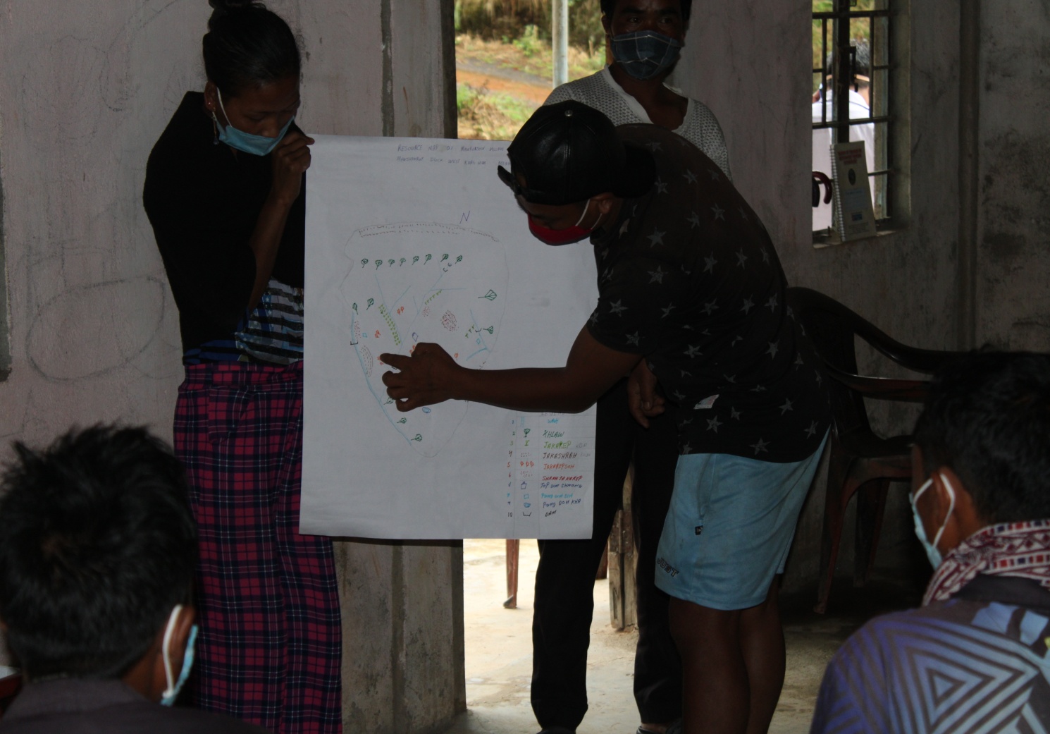
The exercise involving the making of the Village Resource map, village Social Map, KML boundary map of the village was done with the help of the community members. The various social and environmental aspects were plotted on the map by the community. Members of the community are divided into three groups through random counting method. Each group is to participate in the making of the three maps respectively (Resource map, social map, KML boundary map). The DPMU merely facilitates the entire process.
Objectives of PRA at Mawruksoin Village:
The Participatory Rural Appraisal (PRA) exercise at Mawruksoin was conducted with following objectives:
To identify the natural, human, and economic resources of village.
To identify the village problems and prioritize them with the help of the community members.
To prepare the Community natural Resource Management Plan of the village.
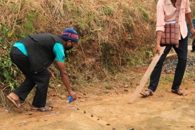
Activity 1: Village Boundary Mapping:
The GIS personnel along with Mr. Preciousking, the sordar of Mawruksoin Village outlined the boundary of Mawruksoin Village on the 18th of August 2020.
Activity 2: Drawing the Resource Map and Social Map
The second step is to involve the local community in preparation of village resource map and Social Map as perceived by the community members to solicit their participation. Infrastructure, services, and other village resources such as agricultural lands, wells, wastelands, cattle population etc. were mapped. Local people prepared the Maps by drawing it on the ground with the help of rangoli and naturally available materials;
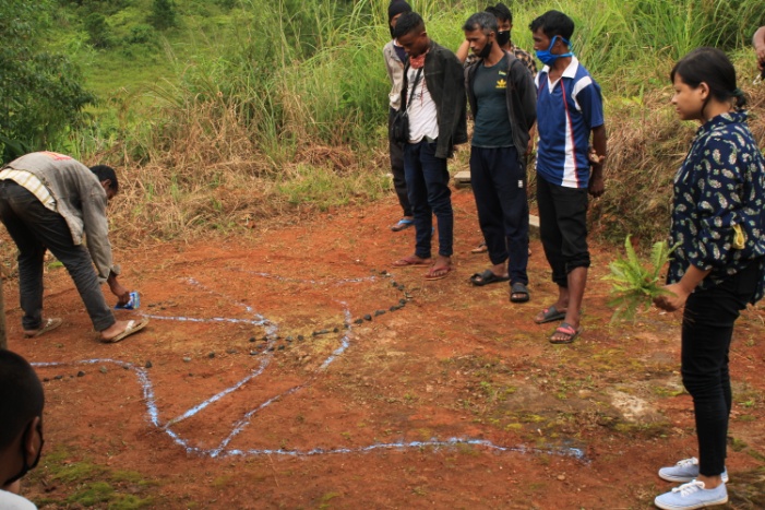
This activity achieved the following purposes:
Analyzed the spatial information, particularly studied problems and opportunities of villagers.
Got an impression about the village setting, physical layout, location of various houses and institutions.
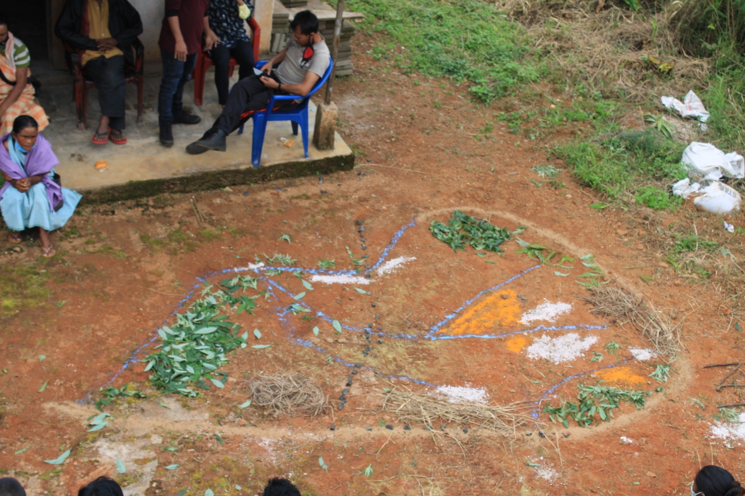
Findings Based on the Resource Map and Social map of Mawruksoin Village:
Main agriculture produce is Paddy.
There are 2 types of Forest ownership: Community and Privately Owned forests.
2 community forest
1 private forest
Four (4) springs are present in the village.
Three main rivers are present and six (6) streams flow through the village.
Presence of Barren land
School: there are only two primary schools in the village.
The village is connected from locality to another through foothpaths and kuccha roads under the MGNREGA scheme.
Habitation is not confined to one place but spread all over the village.
Rationale: This exercise serves as the most basic form of village level information collection as well as to understand the level of which how much the community is aware of their own village.
A limited members of the community participated in the exercise as there are protocols to be followed as given by district administration in relation to the COVID -19 pandemic.
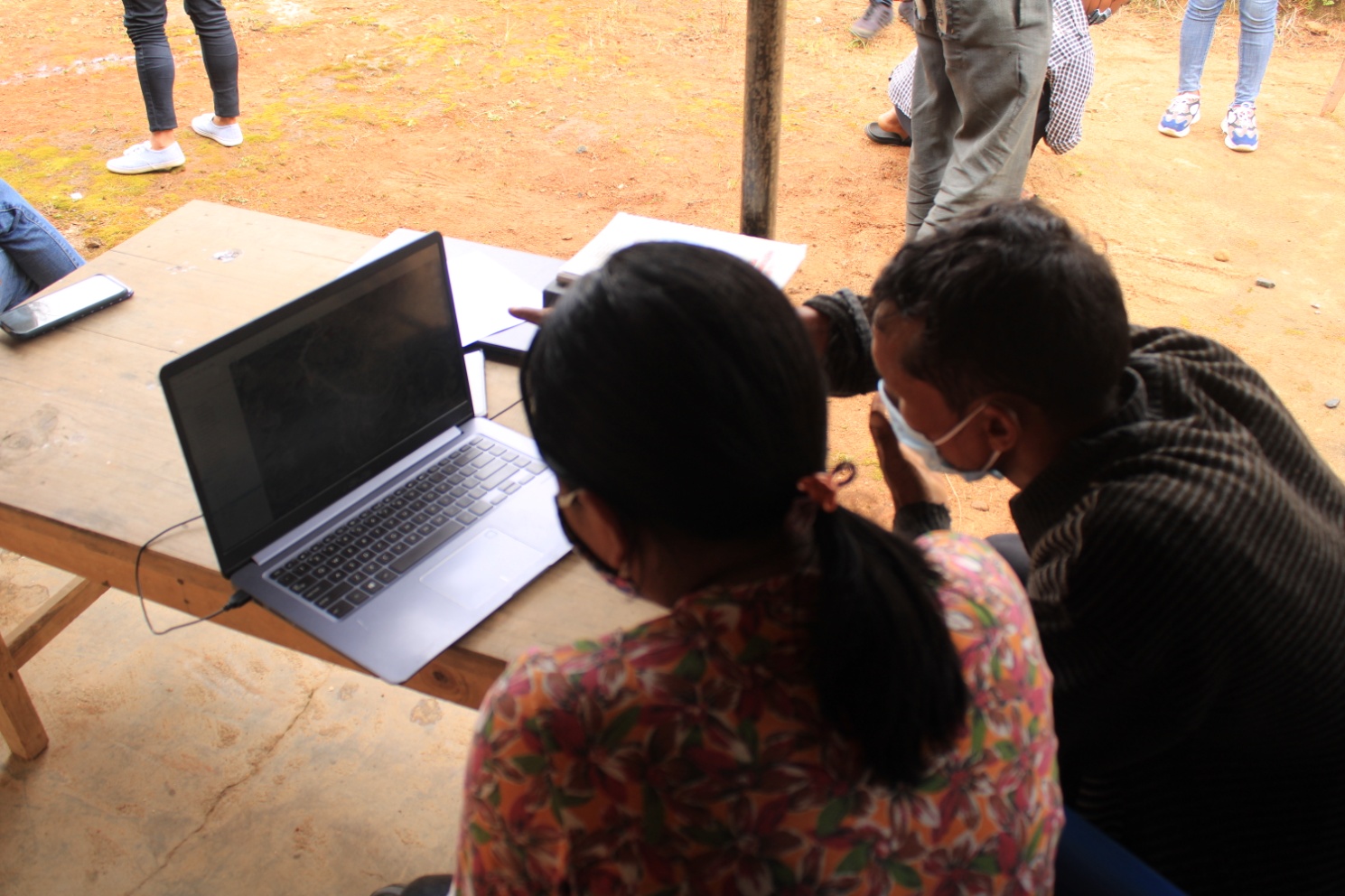
Baseline Data Survey to fill the Environment and Social Template
During the PRA exercise, the CLLMP officials and the community members were divided into groups to fill the Social and Environmental Templates. Discussions and consultations with social groups existing in the village was held to gather basic village information regarding no. of households, demographic information, major crops and enterprises taken in the village, trends of production and productivity of major crops in the village and demographic distribution of village population.
Vision Exercise
On the second day of PRA, the CLLMP team carried out the vision exercise to understand the community’s shared and collaborative vision in order to best serve the needs and expectations of the community. This also reinforces the sense of ownership of the project and can also serve as a project guide to ensure it reflects local priorities.
| MAWRUKSOIN VILLAGE, MAWSHYNRUT BLOCK | ||||
|---|---|---|---|---|
| SL NO | Proposed Activities | From Where | Who will Implement | Target Year of Achievement |
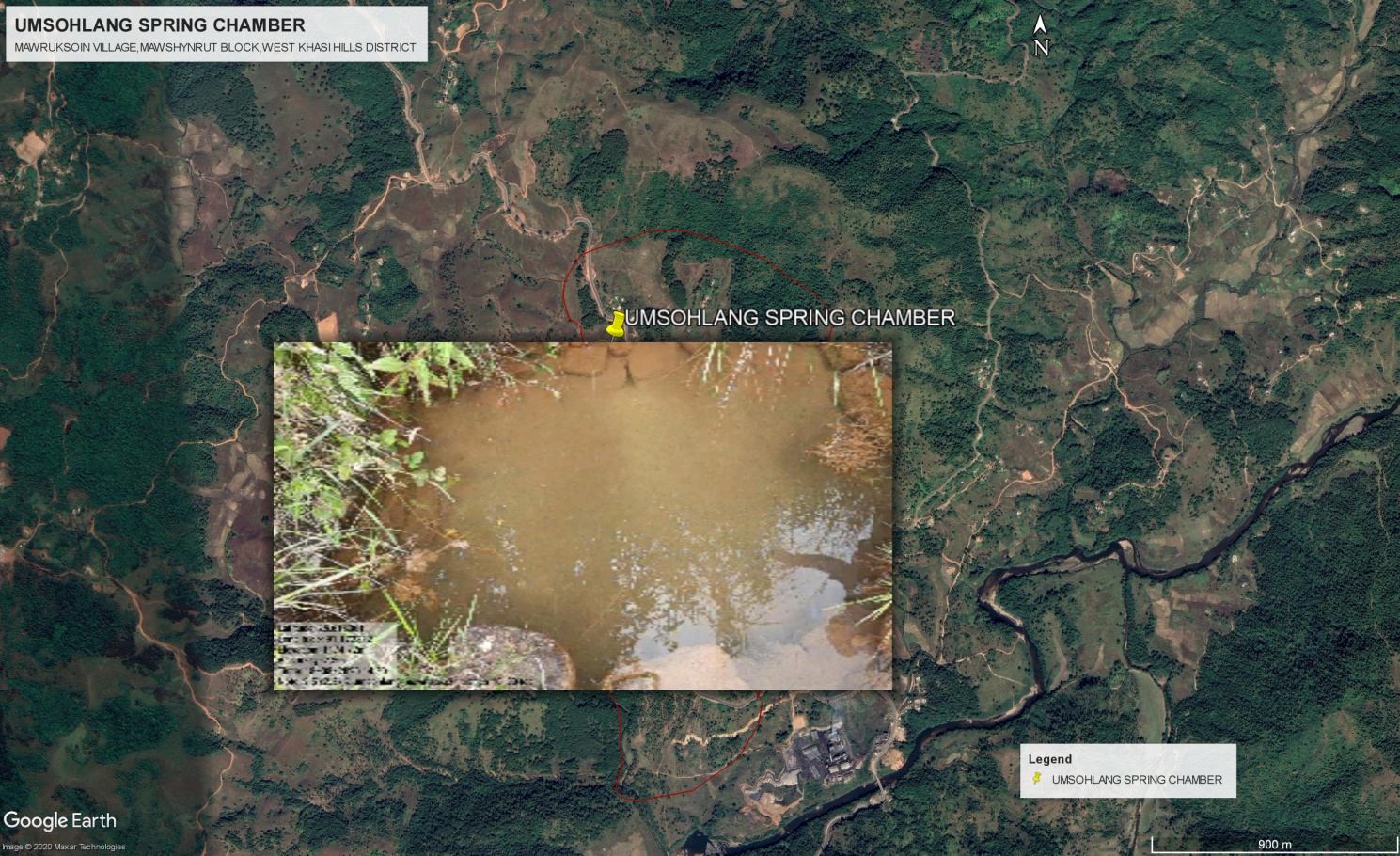
| 1 | Contour trenches+ plantation+ construction of spring chamber, umsohlang | CLLMP Project | VNRMC/Project | 2020-2021 |
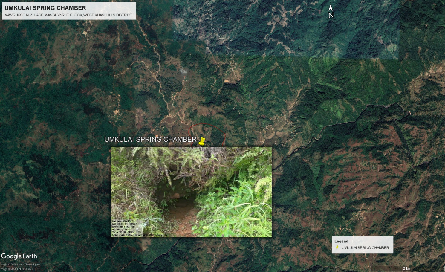
| 2 | Contour trenches+ plantation+ construction of spring chamber, umkulai | CLLMP Project | VNRMC/Project | 2020-2021 |
| 3 | Contour trenches+ plantation+ construction of spring chamber, purdiengdoh | CLLMP Project | VNRMC/Project | 2020-2021 |
| 4 | Check dam cum Irrigation Canal at pursohphoh | CLLMP Project | VNRMC/Project | 2020-2021 |
| 5 | Check dam cum Irrigation Canal at purjari | CLLMP Project | VNRMC/Project | 2020-2021 |
| 6 | Erosion control wall, dewsaw | CLLMP Project | VNRMC/Project | 2020-2021 |
| 7 | Check dam/gully plug, tHemlumjingtep | CLLMP Project | VNRMC/Project | 2020-2021 |
| 8 | Dug out pond/ water conservation, purumknai | CLLMP Project | VNRMC/Project | 2020-2021 |
| 9 | Check dam cum Irrigation Canal at, purkhah | CLLMP Project | VNRMC/Project | 2020-2021 |
| 10 | Check dam, purbhimlar | CLLMP Project | VNRMC/Project | 2020-2021 |
| 11 | Check Dam,purkseh | CLLMP Project | VNRMC/Project | 2020-2021 |
| 12 | Terracing ( fruit trees + seasonal crops), lumshekidar | CLLMP Project | VNRMC/Project | 2021-2022 |
| 13 | Terracing ( fruit trees + seasonal crops), lumdiengling | CLLMP Project | VNRMC/Project | 2021-2022 |
| 14 | Terracing ( fruit trees + seasonal crops), lumkhuti | CLLMP Project | VNRMC/Project | 2021-2022 |
| 15 | Terracing ( fruit trees + seasonal crops), lumshiah | CLLMP Project | VNRMC/Project | 2021-2022 |
| 16 | Terracing ( fruit trees + seasonal crops), lumpatharnong | CLLMP Project | VNRMC/Project | 2021-2022 |
| 17 | Terracing ( fruit trees + seasonal crops), lumtdei | CLLMP Project | VNRMC/Project | 2021-2022 |
| 18 | Terracing ( fruit trees + seasonal crops),lumbhimlar | CLLMP Project | VNRMC/Project | 2021-2022 |
| 19 | Terracing ( fruit trees + seasonal crops),lumumtong | CLLMP Project | VNRMC/Project | 2021-2022 |
| 20 | Composting | CLLMP Project/Agri. Dept. | VNRMC/Project | 2021-2022 |
| 21 | Afforestation at lummawkyrwat Mihngi | CLLMP Project | VNRMC/Project | 2021-2022 |
| 22 | Afforestation mawbrimyndir | CLLMP Project | VNRMC/Project | 2021-2022 |
| 23 | Afforestation at lumklangrin | CLLMP Project | VNRMC/Project | 2021-2022 |
| 24 | Agro-Horti at lumjingtep | CLLMP Project | VNRMC/Project | 2021-2022 |
| 25 | Agro-Horti at lummawbidong | CLLMP Project | VNRMC/Project | 2021-2022 |
| 26 | Erosion control wall, purjari | CLLMP Project | VNRMC/Project | 2022-2023 |
| 27 | Approach Road from Pordidoh to Langja road | BLOCK | VEC/VILLAGE | 2020-2021 |
| 28 | Footpath from Durbar Hall to Bhimlar (800 m approx.) | MGNREGS | VEC | 2020-2021 |
| 29 | Tourist spot at kshaidumphaw | TOURISM DEPT. | VILLAGE | 2021-2022 |
| 30 | Erosion control wall, pursohlang (200m x 2m approx.) | MGNREGS/SOIL DEPT. | VILLAGE | 2022-2023 |
| 31 | Community Hall | MLA/BLOCK | VILLAGE | 2021-2022 |
| 32 | School Building | EDUCATION DEPT/MLA | VILLAGE | 2022-2023 |
PROBLEM ANALYSIS WITH VULNERABLE GROUPS
Do people have sufficient access to supply of fodder, fuel wood, leaf litter? Not sufficient
Has access to timber improved or reduced over the years? How is access for household use and commercial use managed? No, reduced 10 yrs
Are the water bodies facing any threats? Yes, lack of f water conservation activity
Do all people in the village have access to drinking water? What are the challenges?YES, People depend on PHE water supply, and ignore the spring water which is the main source of drinking water in the past decades.
Are there degraded areas in the village (open/ degraded forests, mining affected, high soil erosion etc.)? YES
What has caused this degradation? Are there practices causing threats to availability and access to natural resources? Clearing of forest land for Charcoal, deforestation for logging,Forest fire.
What have been the changes in agricultural practices? Soil fertility, water, pest & diseases
Are there any challenges in farming? Yes, traditional method of farming.
How would you consider the health situation in your village?average
How is the situation of cleanliness, sanitation, access to toilets and waste management? Average, practice of waste management
Who are the most vulnerable in the village? What can be done to improve their lives? Poorest among the poor, grant
What are the livelihood aspirations of the youth? Are there any avenues available?
Do any committees/ institutions/ rules exist to manage and monitor natural resources in the village? YES
What are some of the major issues of conflict in the village? NO
Have any of the above issues been discussed in village meetings? NO
How do people resolve disagreements and conflicts? Mutual understanding with the help of village dorbar.
The Finalized Community Natural Resource Management Plan of Mawruksoin Village
| Area of Intervention | Intervention 1 | Intervention 2 | Intervention 3 | Intervention 4 | Intervention 5 | Intervention 6 | Intervention 7 | Intervention 8 | Remark on any traditional knowledge/ best practice within the village | |
|---|---|---|---|---|---|---|---|---|---|---|
|
|
|
|
|
||||||
| Soil and Water Conservation | Check Dam,purkseh | Check dam cum Irrigation Canal at purjari | Check dam cum Irrigation Canal at pursohphoh | Check dam, purbhimlar | Check dam cum Irrigation Canal at, purkhah | Check dam/gully plug, tremlumjingtep | Dug out pond/ water conservation, purumknai | |||
| Land Productivity Enhancement | Terracing ( fruit trees + seasonal crops), lumshekidar | Terracing ( fruit trees + seasonal crops), lumdiengling | Terracing ( fruit trees + seasonal crops), lumkhuti | Terracing ( fruit trees + seasonal crops), lumshiah | Terracing ( fruit trees + seasonal crops), lumpatharnong | Terracing ( fruit trees + seasonal crops), lumtdei | Terracing ( fruit trees + seasonal crops),lumbhimlar | Terracing ( fruit trees + seasonal crops),lumumtong | ||
| Spring Shed Management | Contour trenches+ plantation+ construction of spring chamber, umsohlang | Contour trenches+ plantation+ construction of spring chamber, umkulai | Contour trenches+ plantation+ construction of spring chamber, purdiengdoh | Contour trenches+ plantation+ construction of spring chamber, murisawktang | ||||||
| Afforestation/ Community Forestry Activities | Afforestation at lummawkyrwatMihngi | Afforestation mawbrimyndir | Afforestation at lumklangrin | |||||||
| Forest area under management plans | Forest area at LummawkyrwatSepngi (2 ha) | - | - | - | - | - | - | - | ||
| Enhancement of Agro-forestry Activities | - | - | - | - | - | - | - | - | ||
| Culturable waste land brought under Horticulture | Agro-Horti at lumjingtep | Agro-Horti at lummawbidong | - | - | - | - | - | - | ||
| Activities to Treat Mining Affected Area | - | - | - | - | - | - | - | - | ||
| Others | Erosion control wall, pursohlang | Erosion control wall, dewsaw | Erosion control wall, purjari | Composting | Tourist spot at kshaidumphaw |
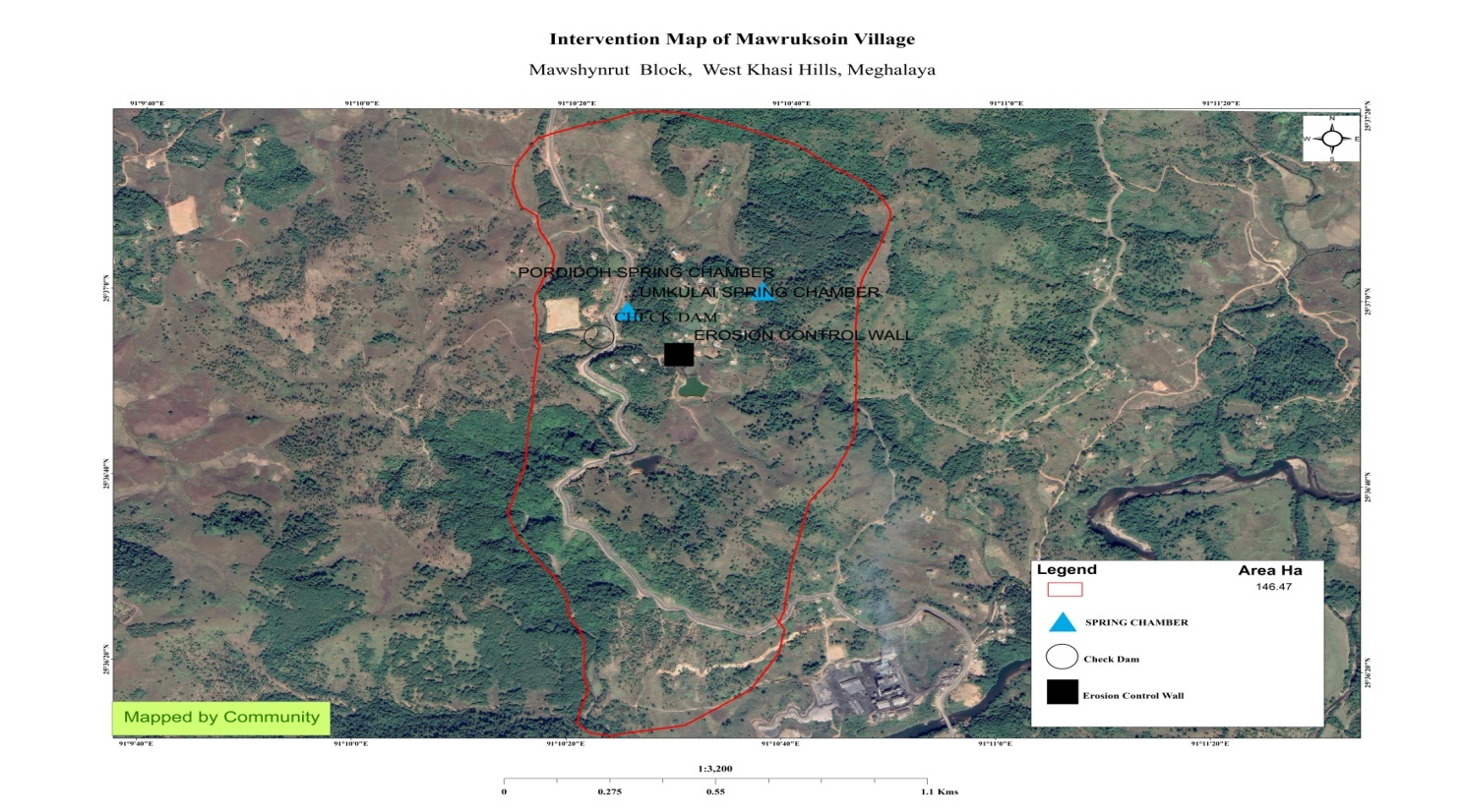
Transect Walk and Site Verification of the proposed sites for NRM Activity.
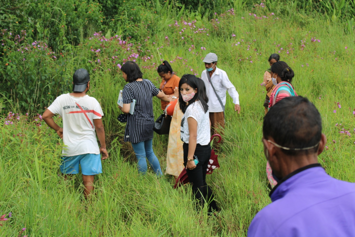
The DPMU team along with the Field Engineer conducted a site verification of all the proposed intervention sites that has been included in the CNRM Plan. Transect walk is the process of PRA to travel across the village from one corner to another along with the community members for verification and observation of the facts supplied by them during social and resource mapping. The purpose was also to have clear concept of the various farming practices, tree plantations, common lands, waste lands, structures slope, soil, forest, grassland, water table and water resources etc.
By means of interaction in the fields, the community members and the CLLMP team members discussed the challenges and NRM activities that can be taken up atdifferent sitesduring the Transect Walk.
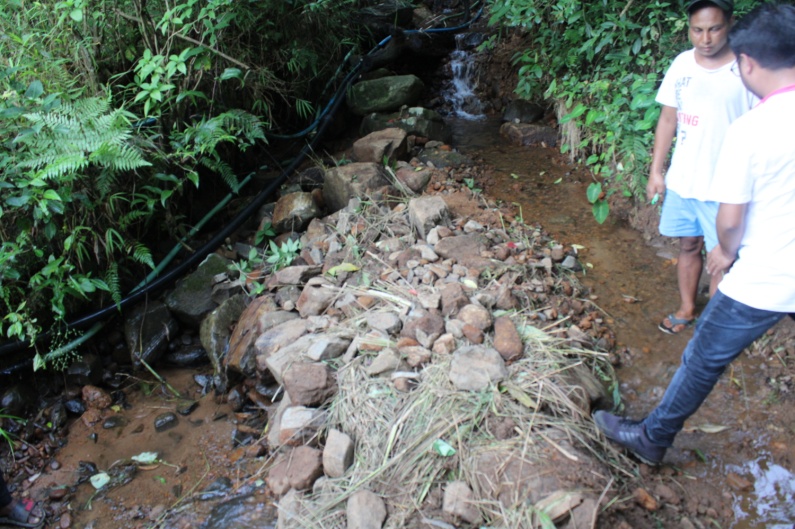
Water Quality testing, Spring Mapping and Discharge Measurement.
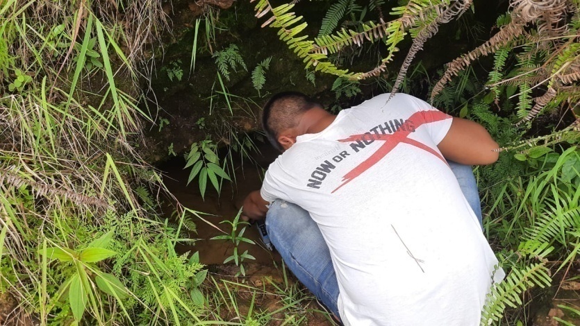
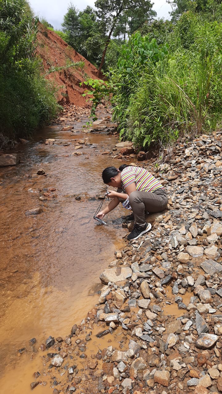
The DPMU engaged in spring mapping, water tracing and discharged measurement at the village. Training on the same was also conducted.
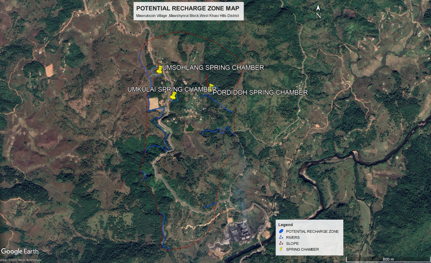
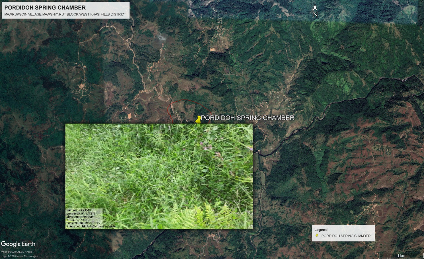
Google Earth image of the delineated potential recharge area/zone of the Spring (with specific interventions marked)
The Finalized Community Natural Resource Management Plan of Mawruksoin Village.
| Area of Intervention | Intervention 1 | Intervention 2 | Intervention 3 | Intervention 4 | Intervention 5 | Intervention 6 | Intervention 7 | Intervention 8 | Remark on any traditional knowledge/ best practice within the village | |
|---|---|---|---|---|---|---|---|---|---|---|
|
|
|
|
|
||||||
| Soil and Water Conservation | Check Dam,purkseh | Check dam cum Irrigation Canal at purjari | Check dam cum Irrigation Canal at pursohphoh | Check dam, purbhimlar | Check dam cum Irrigation Canal at, purkhah | Check dam/gully plug, tremlumjingtep | Dug out pond/ water conservation, purumknai | |||
| Land Productivity Enhancement | Terracing ( fruit trees + seasonal crops), lumshekidar | Terracing ( fruit trees + seasonal crops), lumdiengling | Terracing ( fruit trees + seasonal crops), lumkhuti | Terracing ( fruit trees + seasonal crops), lumshiah | Terracing ( fruit trees + seasonal crops), lumpatharnong | Terracing ( fruit trees + seasonal crops), lumtdei | Terracing ( fruit trees + seasonal crops),lumbhimlar | Terracing ( fruit trees + seasonal crops),lumumtong | ||
| Spring Shed Management | Contour trenches+ plantation+ construction of spring chamber, umsohlang | Contour trenches+ plantation+ construction of spring chamber, umkulai | Contour trenches+ plantation+ construction of spring chamber, purdiengdoh | Contour trenches+ plantation+ construction of spring chamber, murisawktang | ||||||
| Afforestation/ Community Forestry Activities | Afforestation at lummawkyrwatMihngi | Afforestation mawbrimyndir | Afforestation at lumklangrin | |||||||
| Forest area under management plans | Forest area at LummawkyrwatSepngi (2 ha) | - | - | - | - | - | - | - | ||
| Enhancement of Agro-forestry Activities | - | - | - | - | - | - | - | - | ||
| Culturable waste land brought under Horticulture | Agro-Horti at lumjingtep | Agro-Horti at lummawbidong | - | - | - | - | - | - | ||
| Activities to Treat Mining Affected Area | - | - | - | - | - | - | - | - | ||
| Others | Erosion control wall, pursohlang | Erosion control wall, dewsaw | Erosion control wall, purjari | Composting | Tourist spot at kshaidumphaw |
The CLLMP Team also made an inspection to the proposed intervention sites of the CNRMP along with Ms. Lakyntiew Dkhar, FE, CLLMP, SWKH who is responsible for providing the estimates of the plans.
Rationale: The activities for intervention were selected after information has been collected through the templates. The community is devided into two groups for the collection of information. After all necessary information is collected, the two groups are again asked to sit together and discuss on activities to be taken up. The DPMU ensures the participation of women in this session and mediates when there seem to be too much dominance from one group or the other.
Utilizing the social map, LULC map, Resource map for reference, the community is able to make plans and select sites easily.
The above activities were selected after discussion and were selected based on the need of the hour and seasonal relavance. The village feels that the first priority for intervention should be Springshed Development to ensure the protection of their springs and also to ensure that they do not run dry through treatment of catment areas. The check dam was selected to prevent run off of water and to conserve enough water for irrigation through the traditionally made irrigation canals and other domestic purposes.
OBSERVATIONS BY DPMU: The Project implementation activity conducted at Mawruksoin village from the 17th – 25th August, 2020 is the first of its kind in the WKH and SWKH as the aim is to complete all activities within a period f one week. This procedure has both its advantages and disadvantages. The main advantage being that all activities, steps and procedures from the Ground Truth survey to the CNRMP can be completed within a period of one week. The main disadvantage of this method however, is the fact that completion of procedures and activities are rushed and the most important aspects and details are missed.
The procedure for CLLMP implementation though not a herculean task yet it is no walk in the park either. The Project itself is Community-led in nature, hence almost all activities are dependent on community mobilization, decision and rapport building. Each village is different in its approach towards the project, the DPMU and the rate in which relation is build between the village and the staffs. While some villages understand the concept of the Project easily, others take time to even get through the VNRMC formation phase. The common problem for all villages as observed are however related to the formulation of the plans. While the Community itself is no stranger to NRM works, the procedures and templates tend to confuse the community often leading to losing confidence during the activity proposal phase.
The following are some of the feedbacks, observations and inputs as giving by the village of Mawruksoin during:
No time to hold a village Dorbar to make necessary decisions relating to CLLMP implementation as the programme from sensitization till CNRMP is conducted consecutively.
Most information as required in the templates is not readily available. The community needs time to discuss and find proper information regarding certain data (both Social and Environment) in the templates.
More time is required by the community to properly make holistic intervention plans. Moreover the community needs the consultation of the village Dorbar before making any decisions.
Conducting consecutive programmes in one village is not an ideal mode of operation. Community/VNRMC needs time to digest and disseminate information to all members of the community. Communities usually holds a village dorbar after the sensitization where important decisions made, hence a gap of at least one week is needed before initiation of CNRMP. Moreover, the community really struggled in understanding the idea of landscape planning and planning interventions in a landscape.
During planning, the objective is to develop interventions based on the Ridge to valley approach. This is an ideal method of planning interventions in a landscape, but keeping in mind the actual need to achieve targets this approach may not be taken up as most NRM activities depend highly on the season.
It has been observed that during the collection of information for the templates, only a few people participated. After casual interaction with the less reluctant members, it was found that most do not have the freedom to freely communicate yet. The reason being that the concept of the project is not entirely clear yet and more time for discussion with other community members through the dorbar is needed.
It has also been observed that the community tends to communicate more freely in the presence of staffs who speak the local dialect. Interaction is limited and almost scripted when other staffs are present in the room.
It has been observed that due to lack of proper rapport building, most are not comfortable in sharing information during collection of information.
Despite these shortcomings, some community members tries their hardest to participate in the activities and programmes.
Project Implementations:
| 1. | Type Of Intervention | Site Name | GPS Co-ordinates | Amount Sanctioned | Work Status | |
|---|---|---|---|---|---|---|
| SC & TCA (Afforestation) | PURDIDOH | 25.61681 | 91.177145 | 9,280 | Completed | |
| 2. | Type Of Intervention | Site Name | GPS Co-ordinates | Amount Sanctioned | Work Status | |
|---|---|---|---|---|---|---|
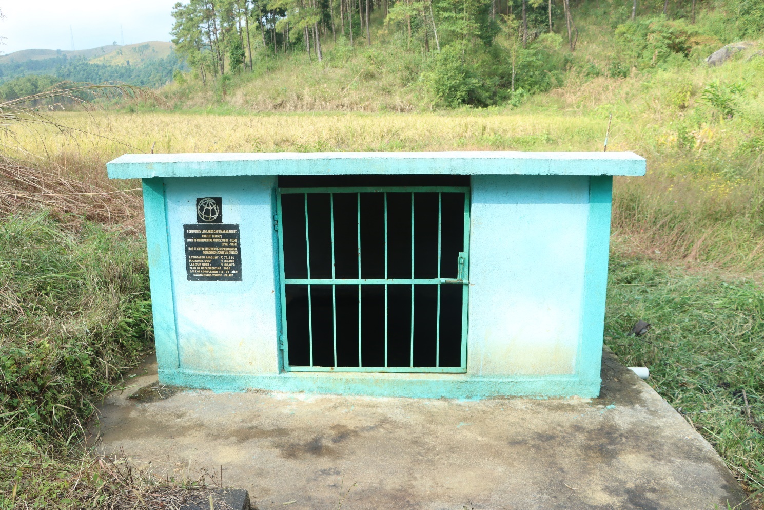
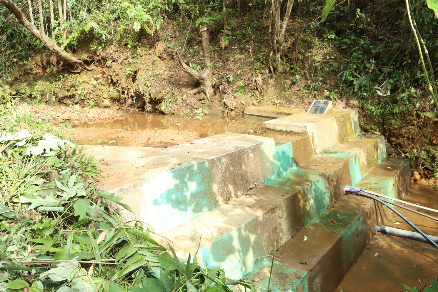
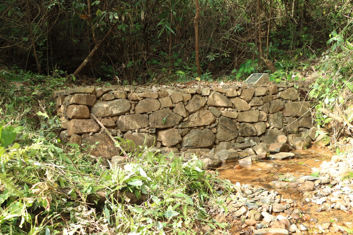
| SC & TCA (Spring Chamber) | PURDIDOH | 25.61681 | 91.177145 | 63,450 | Completed | |
| 3 | Type Of Intervention | Site Name | GPS Co-ordinates | Amount Sanctioned | Work Status | |
|---|---|---|---|---|---|---|
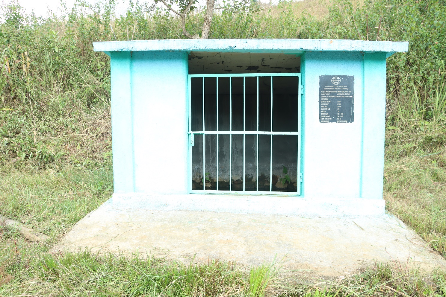
| SC & TCA (Afforestation) | UMSOHLANG | 25.618361 | 91.172392 | 9,280 | Completed | |
| 86,000 | ||||||
| 3 | Type Of Intervention | Site Name | GPS Co-ordinates | Amount Sanctioned | Work Status | |
|---|---|---|---|---|---|---|
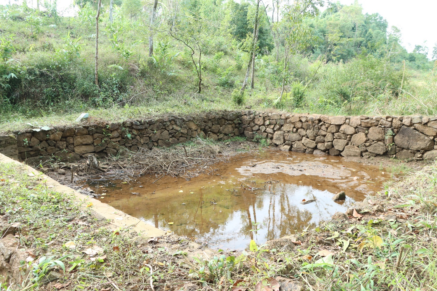
| Dug Out Pond | PURDIDOH | 25.616404 | 91.177399 | 74,300 | Completed | |
| 3 | Type Of Intervention | Site Name | GPS Co-ordinates | Amount Sanctioned | Work Status | |
|---|---|---|---|---|---|---|
| Check Dam | PURSOHPHOH | 25.622819 | 91.173905 | 2,45,400 | Completed | |
| 2. | Type Of Intervention | Site Name | GPS Co-ordinates | Amount Sanctioned | Work Status | |
|---|---|---|---|---|---|---|
| Gully Plug | PURSOHPHOH | 25.622866 | 91.173921 | 48,200 | Completed | |
| 2. | Type Of Intervention | Site Name | GPS Co-ordinates | Amount Sanctioned | Work Status | |
|---|---|---|---|---|---|---|
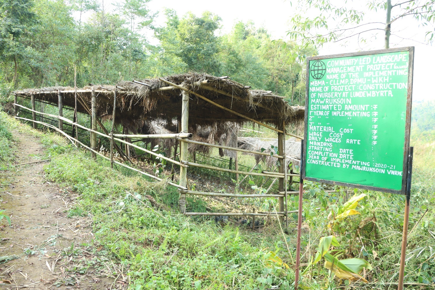
| Nursery | Purdidoh | 25.61668528 | 91.17688417 | 1,50,530 | Completed | |
| 2. | Type Of Intervention | Site Name | GPS Co-ordinates | Amount Sanctioned | Work Status | |
|---|---|---|---|---|---|---|
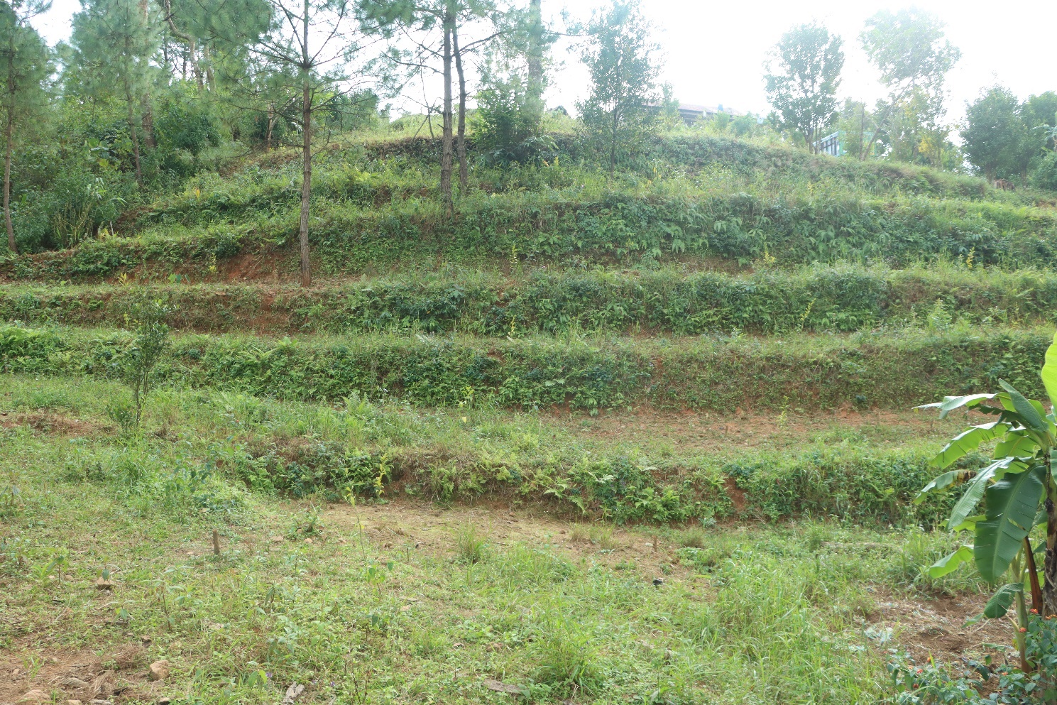
| Terrace Farming | Lumdiengshiah | 25.617398 | 91.175275 | 47,600 | Completed | |
Fund Status:
| Fund Released to VNRMC (Project Implementation) | Total No. of Work Order Issued | Total amount Issued under CLLMP (Per Activity) | Total Amount Spent | Start Date | End Date |
|---|---|---|---|---|---|
| 21,55,000 | SC & TCA (Afforestation) | 9,280 | 07-Dec-20 | 15-Jan-21 | |
| SC & TCA (Spring Chamber) | 78,720 | 07-Dec-20 | 15-Jan-21 | ||
| SC & TCA (Afforestation) | 9,280 | 12-Jul-21 | 16-Jul-21 | ||
| SC & TCA (Spring Chamber) | 1,44,450 | 10-Feb-21 | 23-Feb-21 | ||
| Dug Out Pond | 74,220 | 10-Dec-20 | 13-Jan-21 | ||
| Check Dam | 2,45,335 | 06-Jan-21 | 16-Feb-21 | ||
| Gully Plug | 48,200 | 24-Feb-21 | 11-Mar-21 | ||
| Nursery | 1,90,051 | 03-May-21 | 22-Sep-21 | ||
| Terrace Farming | 30,653 | 26-Apr-21 | 08-May-21 | ||
| Terrace Farming | 30,000 | 13-Sep-21 | 24-Sep-21 | ||
| Terrace Farming | 50,730 | 26-Apr-21 | 08-May-21 | ||
| Terrace Farming | 79,040 | 11-May-21 | 22-Sep-21 | ||
| Terrace Farming | 62,000 | 17-May-21 | 08-May-21 | ||
| Establishment of Horticulture | 69,280 | 16-Jun-21 | 24-Sep-21 | ||
| Establishment of Horticulture | 1,42,280 | 16-Jun-21 | 08-May-21 | ||
| Establishment of Horticulture | 50,000 | 16-Jun-21 | 16-Jun-21 | ||
| Spring Chamber | 80,344 | 22-Mar-22 | 22-Apr-22 | ||
| Construction of Check Dam | 2,39,919 | 04-Apr-22 | 13-May-22 | ||
| Establishment of Agro-Horticulture with Bench Terracing (Terracing) | 1,22,970 | 25-Apr-22 | 26-May-22 | ||
| Establishment of Agro-Horticulture with Bench Terracing (Terracing) | 11,300 | 25-Apr-22 | 26-May-22 | ||
| Establishment of Agro-Horticulture with Bench Terracing (Agro Horticulture) | 30,817 | 02-May-22 | 20-May-22 | ||
| Establishment of Agro-Horticulture with Bench Terracing (Terracing) | 11,300 | 02-May-22 | 20-May-22 | ||
| Establishment of Agro-Horticulture with Bench Terracing (Agro Horticulture) | 54,261 | 28-Apr-22 | 31-May-22 | ||
| Establishment of Agro-Horticulture with Bench Terracing (Terracing) | 22,600 | 28-Apr-22 | 31-May-22 | ||
| Filter Tank | 2,69,600 | 26-Jun-22 | 19-Aug-22 | ||
| Water Harvesting Tank | 2,64,600 | 26-Jun-22 | 20-Aug-22 | ||
| Establishment of Horticulture | 80,540 | 16-May-22 | 21-May-22 | ||
| Total Amount Spent | 25,01,770 | ||||