TABLE OF CONTENT
2. COMMUNITY LED LANDSCAPE MANAGEMENT PROJECT (CLLMP)………………………………………………………………………………………...……...2
- First Contact ……………………………………..………………………………….3
- Findings …………………………………………………………………………..4
- Interpretation ……………………………………………………..…………….10
4. ACTIVITIES
- Sensitization & Ground Truthing ………………………………………………12
- Formation of VNRMC ……………………………………………………14
- Opening of Bank Account ……………………………………………………18
- PRA Exercise ………..………………………………………………………..24
5. DEVELOPMENT OF THE COMMUNITY NATURAL ERESOURCES MANAGEMENT PLAN (CNRMP)
- Plan Estimate……………………………………………………………………….27
- Project Implementation……………………………………………………………28
6. CNRMP TEMPLATES
- Village Summary…………………………………………………………………..30
- Village Functionaries………………………………………………………………34
- Resource Mapping …………………………………………………………………37
- Land Use Pattern…………………………………………………………………..38
- Problem Analysis…………………………………………………………………..46
- CNRM Plan Preparation…………………………………………………………..56
- CNRMP Check List………………………………………………………………...75
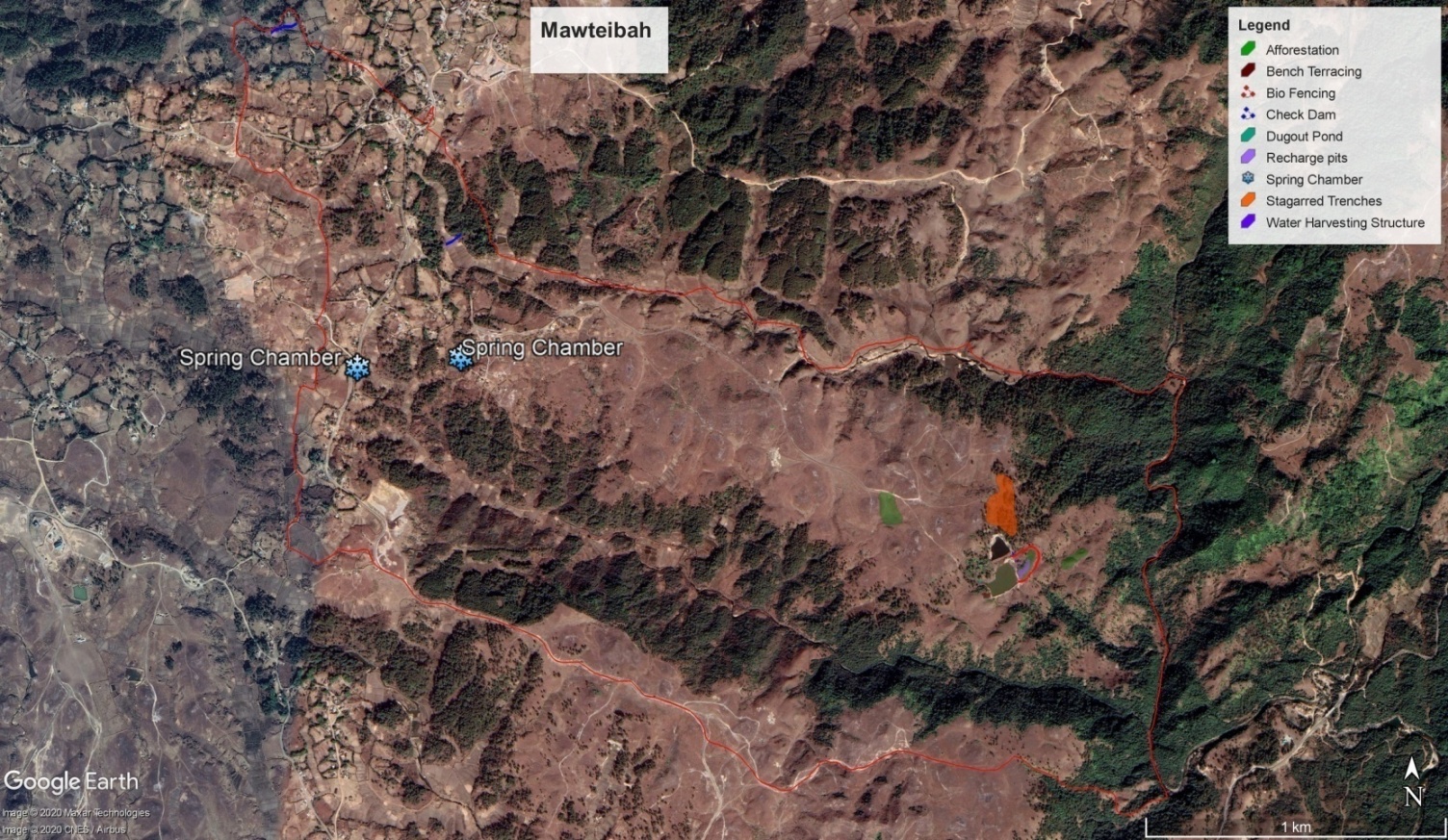
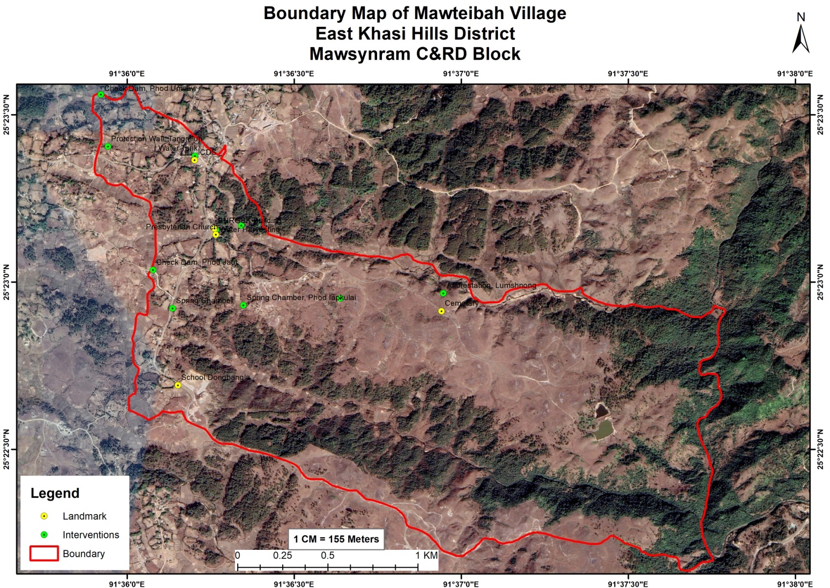 Village Boundary Map
COMMUNITY LED LANDSCAPE MANAGEMENT PROJECT (CLLMP)
The Government of Meghalaya with financial help from the World Bank is implementing the Meghalaya Community Led Landscape Management Project (MCLLMP). The project covers the entire state of Meghalaya and implementation of community-led plans are rolled out in a phased manner throughout the state. The Meghalaya Basin Management Agency (MBMA) will facilitate community-led planning by providing support, technical inputs and funding.
The project is intended to strengthen community- led natural resources management in selected landscapes within the 7 districts of the state. This would be achieved through a variety of planning, capacity building, and on-the-ground interventions to promote the conservation, sustainable use of natural resources, social inclusion and community mobilization; building traditional knowledge and learning, mapping of natural resources management; strengthening the community institutions and creating linkage with financial institutions and community organizations.
The project interventions will include preparation of community led natural resource management plans. The CLLMP has the following three components:
Strengthening Knowledge and Capacity of Communities for Natural Resources Management
Community-Led Landscape Planning and Implementation
Project Management and Governance
The project objective is “to manage and conserve the natural resources, especially forests, soil and water sources, in a manner that supports the financial and physical well-being of communities in the State”
Village Overview
The first contact with Mawteibah was established with the headman of the village Bah Johnsing Lyngdoh on the 5th of June, 2019. Ground truthing was also done on the same day. Some of the findings after discussion with the headman and ground truthing were:
The village is rural.
VEC is actively performing in the village.
There is little degradation (deforestation, soil erosion) prevalent
Findings
Traditional and Indigenous Practitioners in the Village people
They still practice traditional healing methods
Various Government Schemes availed in the village
Mahatma Gandhi National Rural Employment Guarantee Act
Indira Gandhi Awas Yojana Gramin (IAY)
Watershed
Indigenous Food available
Pu-tharo
Pu-Saw
Pu-syep
Pu-Thap
Pu-Sla
Pu-Khlein
Shriew, Phankaro
Women Participation in the Village
Allowed to attend the village Dorbar.
Allowed in the decision making process at the Village Employment Committee and Dorbar Kyrpang.
Challenges faced by the people in the village
Water supply
Liquor (Alcohol Problem)
Education
Medical facilties
Numbers of CBO/ SHGs/ CLUBS in the Village
1 Self Help Groups
Activities Carried out in the Village
Cleaning Drive.
Tree Plantation every year.
Protection of forest fire.
Number of Fair price shop
1 FPS
Prices of essential Commodities
Rice ₹3/- per Kg ( PHH & AAY )
Kerosene ₹40/- per liter
Sugar ₹35/- kg
Flour ₹13/-kg
Amount of Kg/ Liter received for each Commodity
Rice 6Kg per head
Kerosene 2liter per card
Sugar 2kg per card
Flour 1kg per card
Type of Ration Cards
Priority Household (PHH) Card
Non-Priority Household (PHH) Card
Antyodaya Anna Yojana (AAY) Card
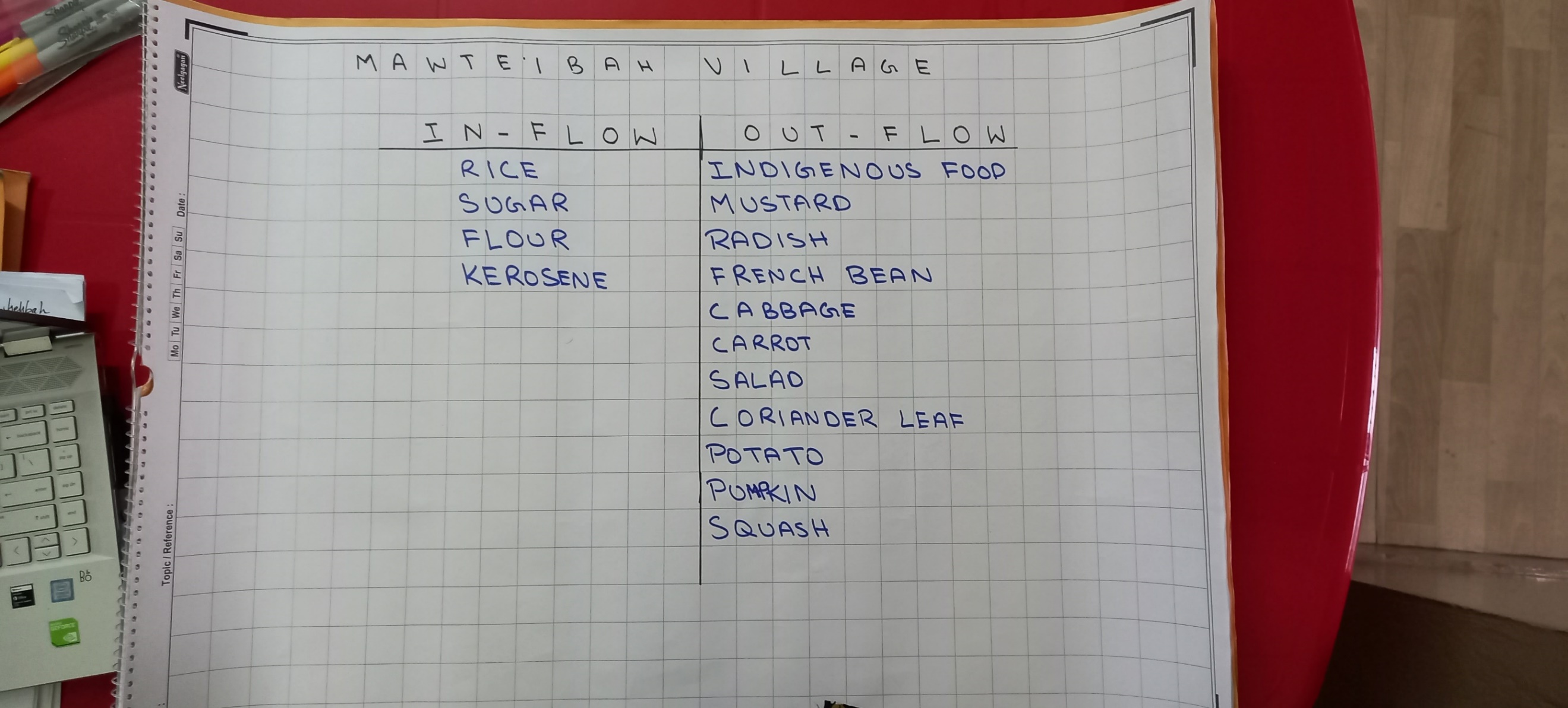
Inflow of Resources
Sugar
Rice
Kerosene
Flour
Farming methods practiced in the village
Traditional Farming Practices
Types of Fertilizers
Cow dung
Marketability of Crops
Once a week (depends on weather conditions)
Distance to the Market- 16 km
Mode of transport: Local transport (Bolero Pickup truck, Sumo and commercial vehicles)
Daily Wage
₹120-₹300
Seasonal crops cultivated
Mustard leaves, Radish and peas
Potato, Salad, carrot and pumpkin
Paddy, Cabbage, chilly and sweet potato.
Number of Local Market & Frequency
Twice a week at Laitmawsiang the adjacent village.
Market Authority
Syiemship
Taxation in the Local Market
Yes
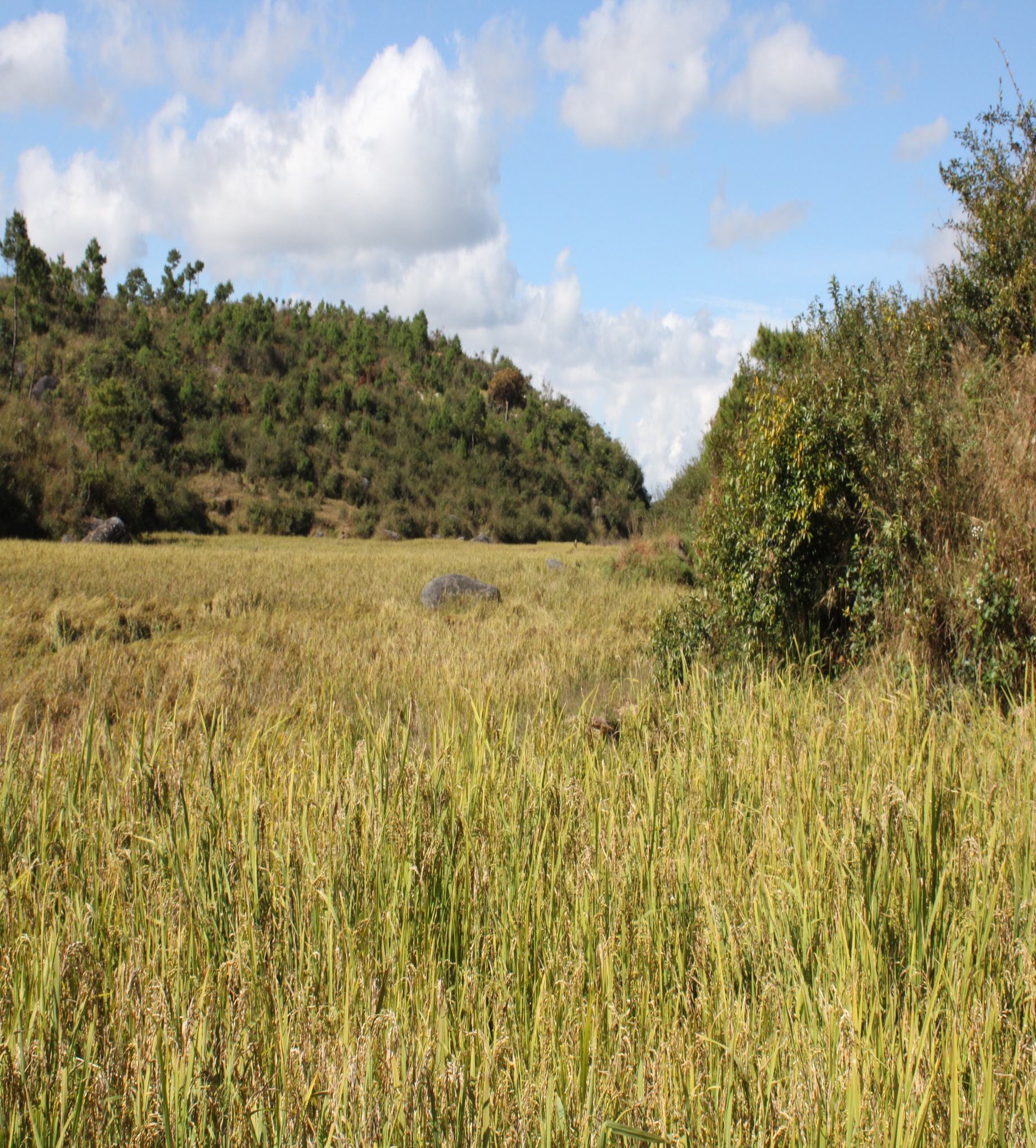
LAND USE PATTERN
Land Ownership
Private
Community
Raid/Hima
Land usage
Farming
Home
Natural Features of the Land
Mountains and Hills
Flat grassy Areas
Tress and other vegetation
Natural and Man-made Disasters
Hailstorm
Deforestation
Forest Fires
Flora and Fauna
Syntiew Krismas
Lasiriong
Tiewdieng
Tiewrakot
Maintenance problem of the land
Natural calamities
Sacred or protected areas/ forest in the community
Yes there are
Views and opinions on the context of the land
Need more capacity building
Details of landholding
Marginal farmers
Small farmers
Types of Natural Vegetation
Trees
Medicinal Plant
Major trees in the Village
Lakait
Dieng jain
Dieng jri
Trees that helps in Spring Discharge
Lakait
Dieng jain
Dieng jri
Sharing Of catchment Areas with other villages
No only self
WATER SOURCES
Main Source of Water
Public Tap
Spring
Stream
Main source of Drinking Water
Public Tab/PHE
Spring
Time taken to fetch water (in minutes)
5 minutes
Frequency of water supply
Twice a day
Availability of water (per day)
1-2 hours
Quality of the water
Average
Colour of the water
Clear
Water Scarcity months
February to April
Is water source well maintained?
No
Satisfaction of drinking water supply
Yes
ENVIRONMENT
Availability of traditional environmental protection beliefs
No
Waste management system
Yes (Bio-Degradable)
Is Deforestation practice in the village
Yes for Fuel wood
Is Afforestation practice in the village
Yes, once a year
Soil Erosion
Yes
Interpretation
Traditional and Indigenous Practitioners in the Village people
Traditional healing is one of the main practice in the village where the people can rely on them in terms of sickness and injuries. If the condition is not that critical the people prefer traditional healers rather than going to hospital. In major cases, people do refer themselves to hospitals.
Government Schemes availed in the village
Schemes like MGNREGA, IAY and watershed schemes are the most major active in the village in terms of regularity and services to improve their overall well-being in the village. The village is highly dependent on these schemes and services provided by the Government.
Indigenous Food available
The village has a rich source of indigenous food that’s have been practice by their ancestors and has continued till today in the present generation. Some of the indigenous food available in the community are Putharo, Pu Saw, Pusyiep, Puthap, Pu sla, Pu Khlein, Yam and Sweet potato.
Women Participation in the Village
The village shows equal participation of women in the village in the decision making process at the VEC (Village Employment Committee) and the Dorbar Kyrpang. They are allowed to shared their views and opinions on several community issues and hold important positions in the Village Employment Committee and take part actively in the Dorbar.
Problems and Challenges faced by the people in the village
There are numerous problems in the village but the FGD identified three important issues:
A concerning issues in the village is the rise of alcohol problem in the community.
Lack of water supply
Poor education system in the village
Lack of medical facilities in the village
Numbers of CBO/ SHGs/ CLUBS in the Village
The village is constituted only 1 self help Group which is actively functioning and act as contributors to the well-being of the village.
Land use Pattern
With regard to land ownership most lands are owned by private individual, community and Raid/Hima. Most lands are being used for building shelters and farming and in terms of natural features of the land it consists of mountains and hills, flat grassy areas and trees and other vegetation.
Three types of trees that are found in the village that contributes to the development of spring discharge are Laakait, DiengJri and Diengjain.
From the baseline study it was also found that there are risk of landslides, deforestation and forest fire which affects the well being of the village.
Water Source
From the study, it is found that the main source of water in the village are from public tap, stream and spring, the main sources of drinking water are from PHE taps and spring. It can be interpreted that the villages do not received frequent supply of water and are not satisfied with the water supply frequency which is twice, but they are satisfied with the quality of water since it is clear. There is a water shortage form the month of February till April.
Environment
The people understand the term and the importance of conserving the forest and its resources. The village follows some waste management and plastic management practices but they do not follow any traditional practice in protecting the environment. Deforestation is also prevalent in the village for fuel wood but they also practice of afforestation once every year.
Project officials from the District Project Management Unit (DPMU) of East Khasi Hills visited Mawteibah village on the 5th of June 2019 for Ground Truthing.
The village has 141 Households. Out of the 141 HHs, 92 belong to the below poverty line (BPL) category.
It has an actively performing VEC.
There are three community forests and one private forest.
Community forests are primarily used fo firewood.
There are two protected forests as well.
Indigenous tree species like Diengkseh Bilat, Diengdoh, Diengsohphie, Sohphoh,Diengsai, Diengngan etc.
Fauna species (deer, rabbit, fox)
Medicinal herbs are also found here
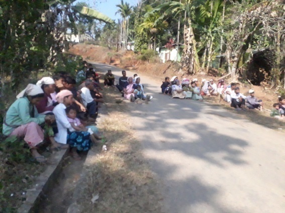
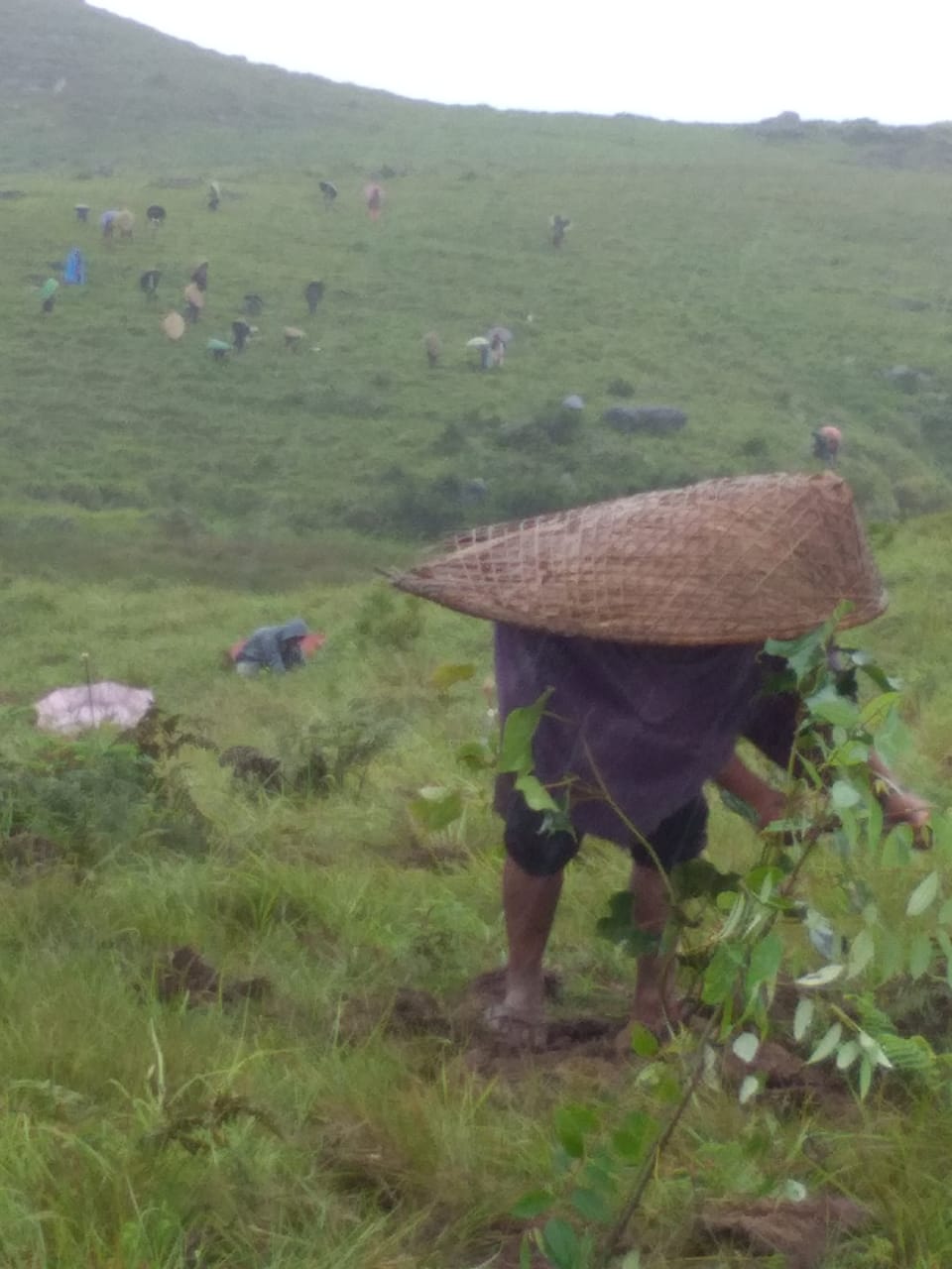
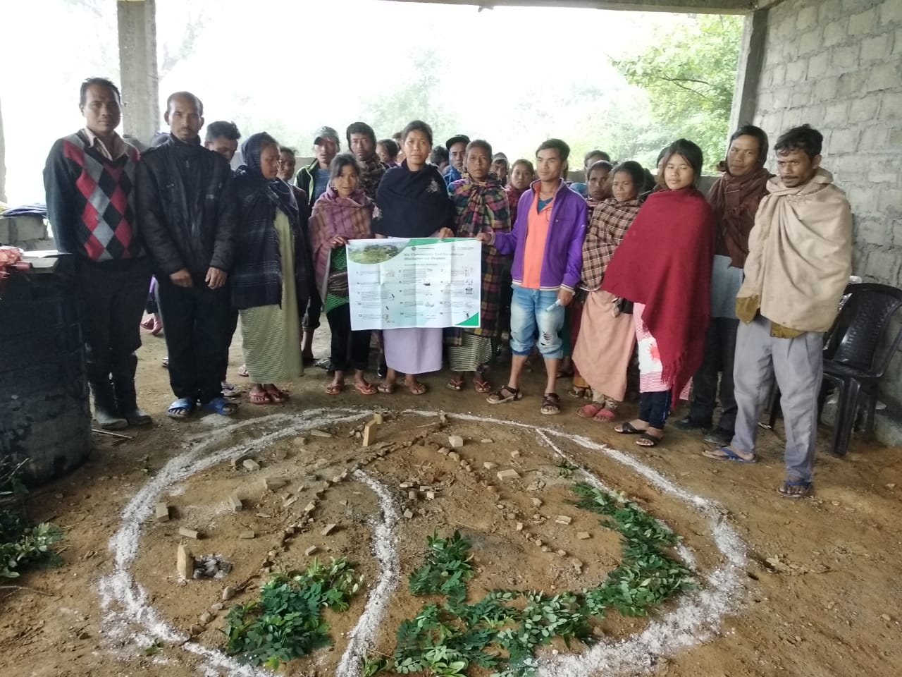
The sensitization programme took place on the 5th of June, 2019 at the Community Hall of Mawteibah Village. The headman of the village presided over the programme. Around 45 community members including women and children attended the sensitization program.
The Program was followed by an interactive session to answer the doubts and questions of the villagers.
The programme on this day also coincided with Environment’s Day and after which all the residents of the village took part in an afforestation programme which the project officials also took part.
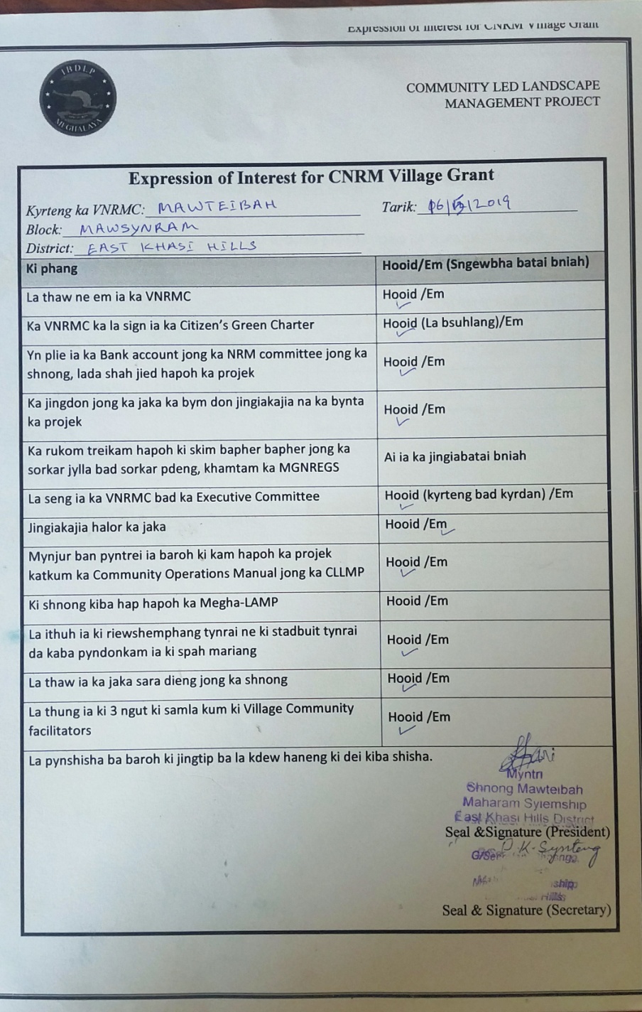
Signing of Documents: After the interactive session, the village signed the EOI, VGA and Green charter followed by the selection of candidates for the Village Natural Resource Management Committee. The Village Executive Committee (VEC) and the entire community carried out the procedure and elected the members of the VNRMC on the same day.
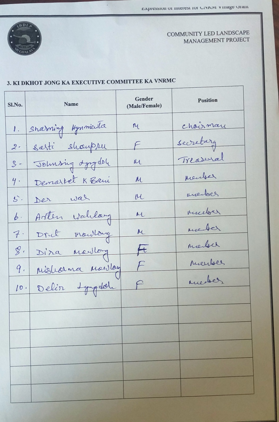
Formation of the VNRMC
The Formation of the Village Natural Resource Management Committe was done in a public meeting in the presence of the entire village and the CLLMP staff. The community itself chose the President, the Secretary and the other executive members of the Committee.
Listed below are the members of the VNRMC:
| Village Natural Resource Management Committee (9 member committee constituted from Village Council, SHG group, Women’s group, youth, VEC) | |||||||||
|---|---|---|---|---|---|---|---|---|---|
| Name in Full | Designation | Gender M/F | Age (Yrs) | Education | Occupa-tion | Community | Religion and Denomination | Contact No and email address | |
| Sharming Hynniewta | President | M | Khasi | Christian | |||||
| 2 | Sorti Shanpru | Secretary | F | Khasi | Christian | ||||
| 3 | John Sing Lyngdoh | Member | M | Khasi | Christian | ||||
| 4 | Demarket Kharbani | Member | M | Khasi | Christian | ||||
| 5 | Arten Wahlang | Member | M | Khasi | Christian | ||||
| 6 | Drut Mawlong | Member | M | Khasi | Christian | ||||
| 7 | Dira Mawlong | Member | F | Khasi | Christian | ||||
| 8 | Delir Lyngdoh | Member | F | Khasi | Christian | ||||
| 9 | Misharna Mawlong | Member | F | Khasi | Christian | ||||
The opening of the bank account was initiated after the village signed the EOI (Expression of Interest), the VGA (Village Grant Agreement) and the Green Charter.
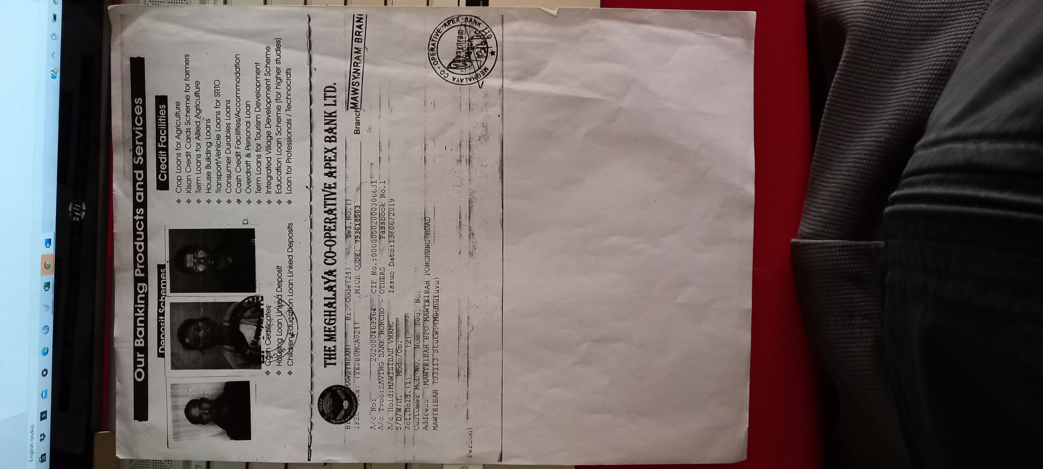 Subsequently, a meeting
with the members of the VNRMC was also convened at the DPMU’s office
to elucidate the Book Keeper/Treasurer of the village on Book
Keeping.
Subsequently, a meeting
with the members of the VNRMC was also convened at the DPMU’s office
to elucidate the Book Keeper/Treasurer of the village on Book
Keeping.
The PRA exercise aims to incorporate the knowledge and opinions of the community in the planning and management of development projects and programmes. PRA exercise at Mawteibah Village took place on the 5thof June, 2019. There were a total of 45 villagers taking part in this exercise who contributed their time and knowledge to this project.
Seasonal Calendar
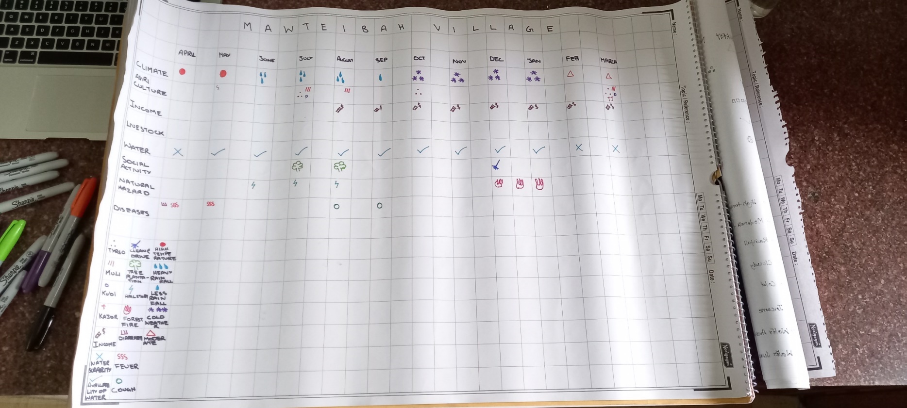
Inflow Outflow
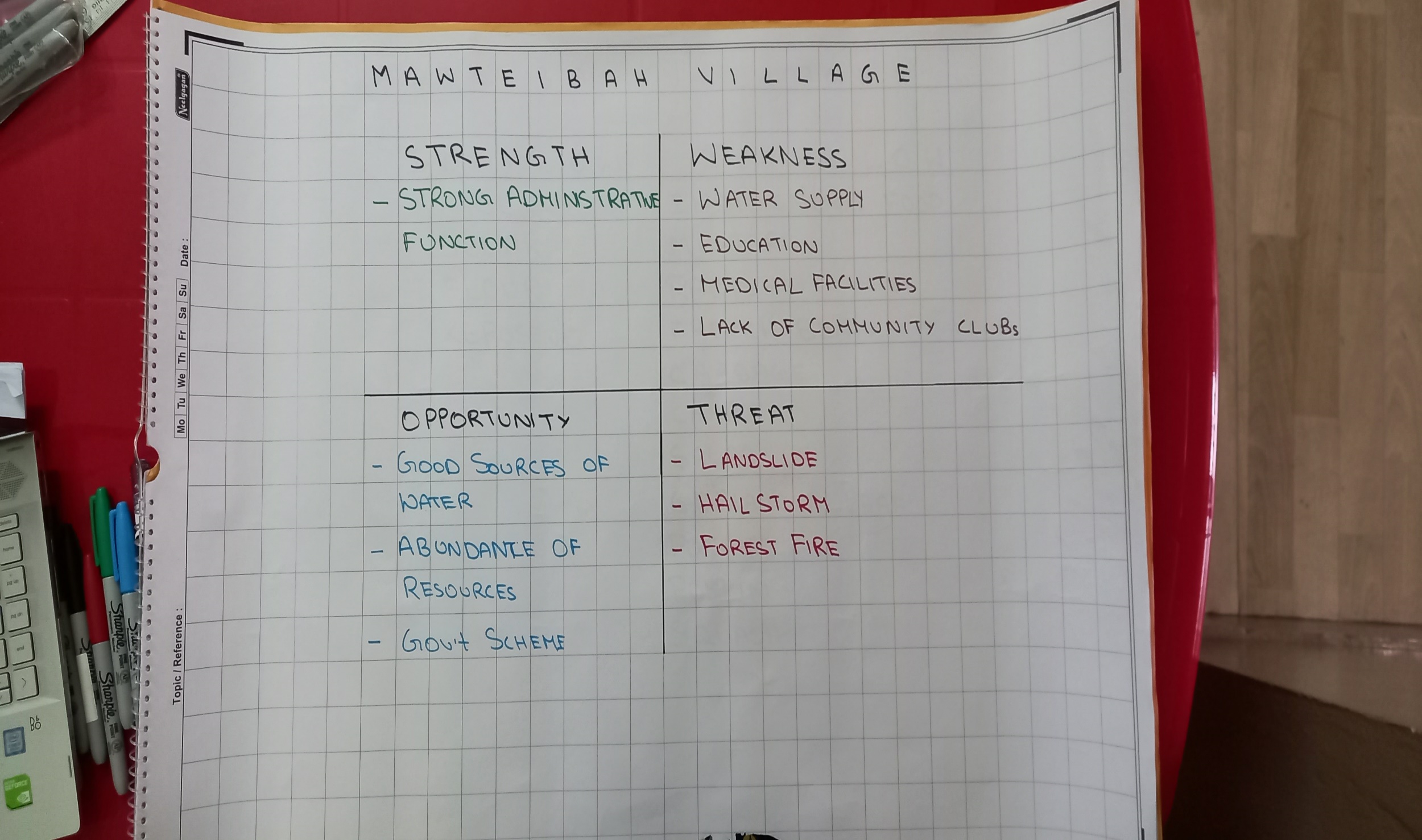 SWOT (STRENGTH,
WEAKNESS, OPPORTUNITY, THREATS)
SWOT (STRENGTH,
WEAKNESS, OPPORTUNITY, THREATS)
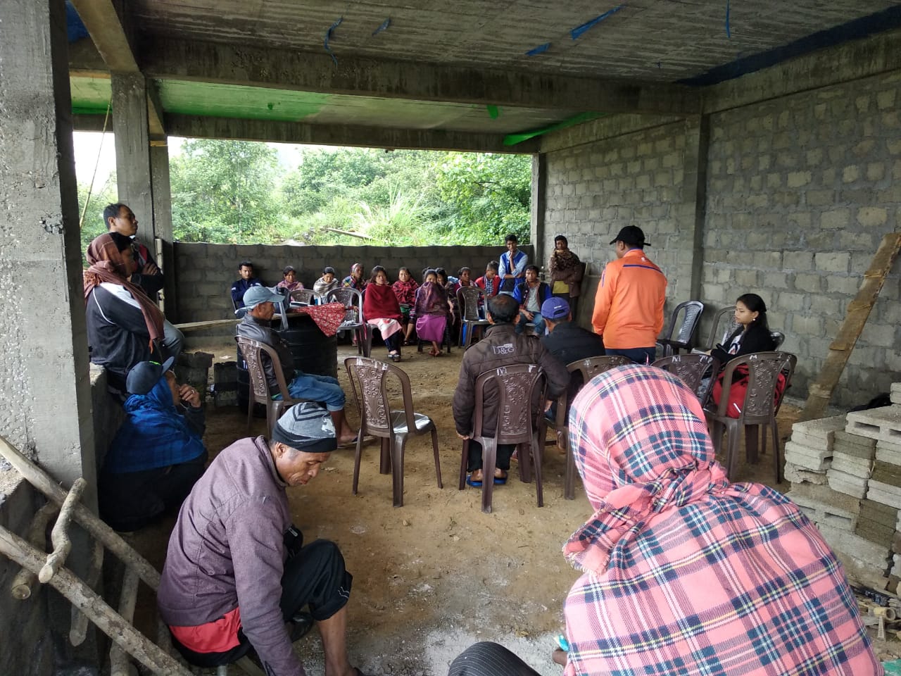
The Community Natural Resource Management Plan was prepared at a village level meeting (dorbar meeting) held on the 14th of June, 2019. A total of 23 men and women from the village, including members of the Village Natural Resource Management Committee (VNRMC) were present to voice their problems and opinion while preparing the Community Natural Resource Management Plan.
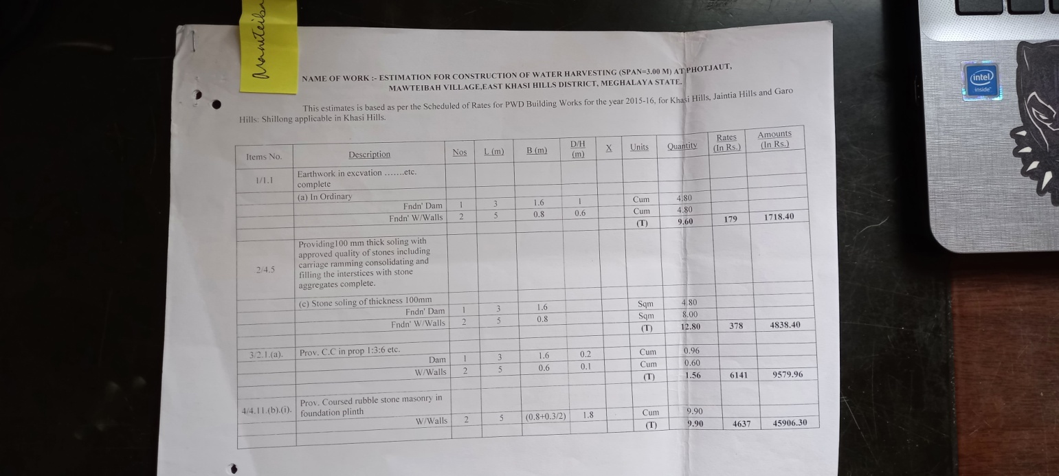
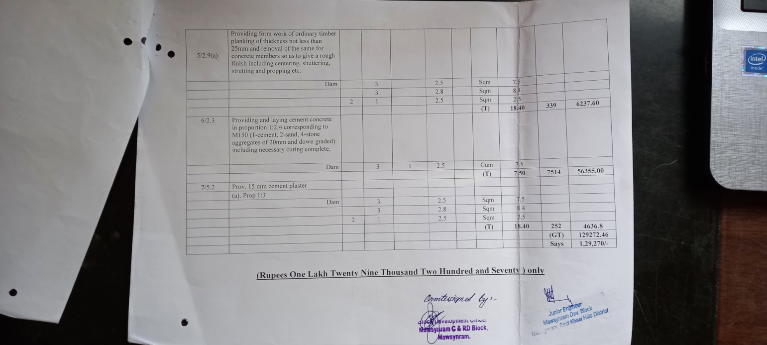
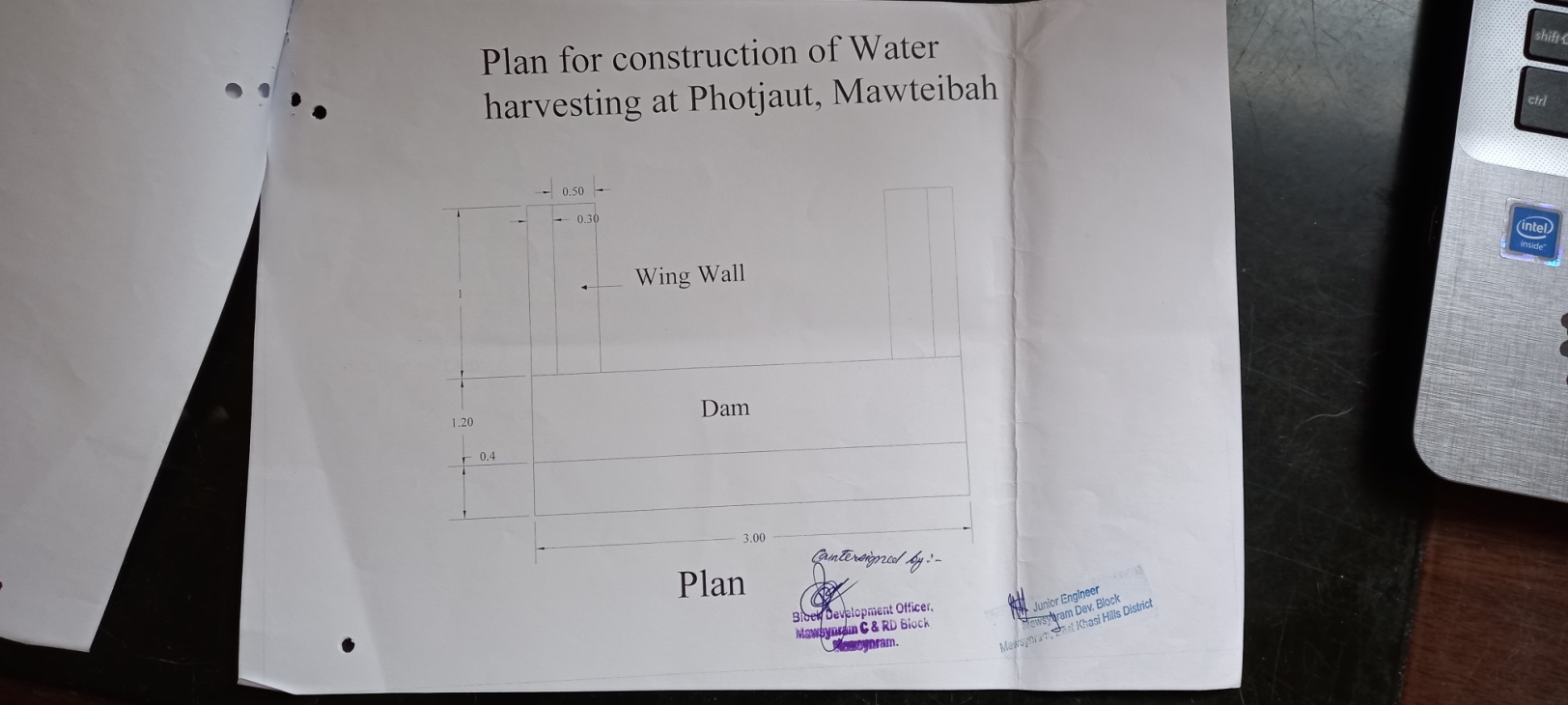
Plan Estimate:
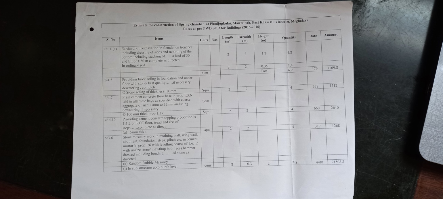
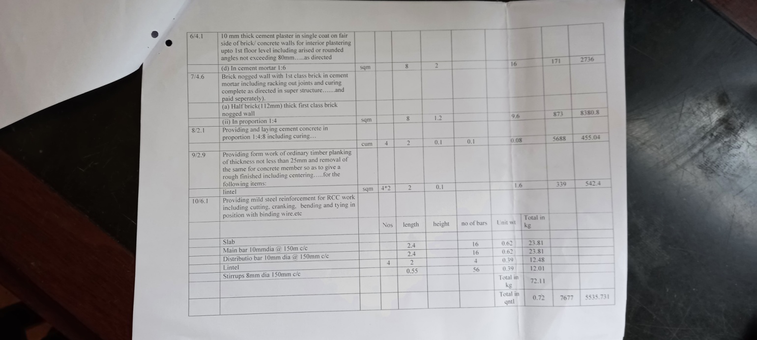
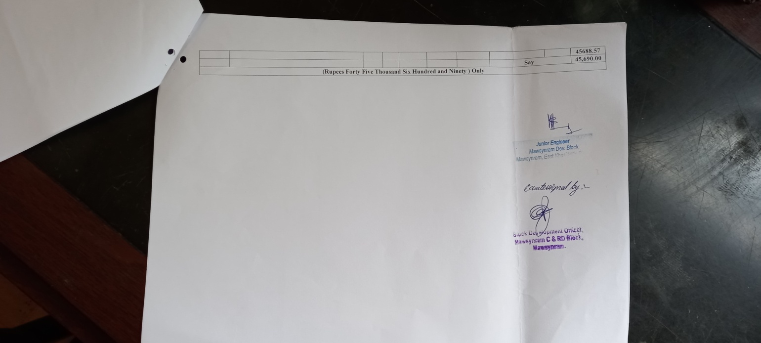
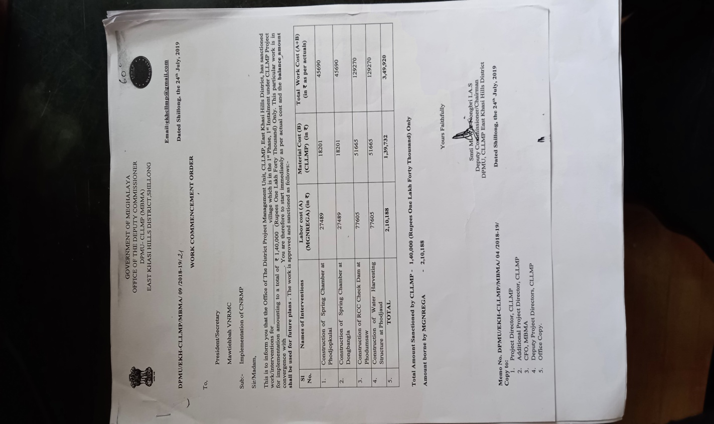
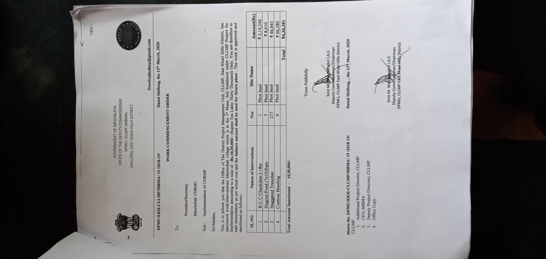
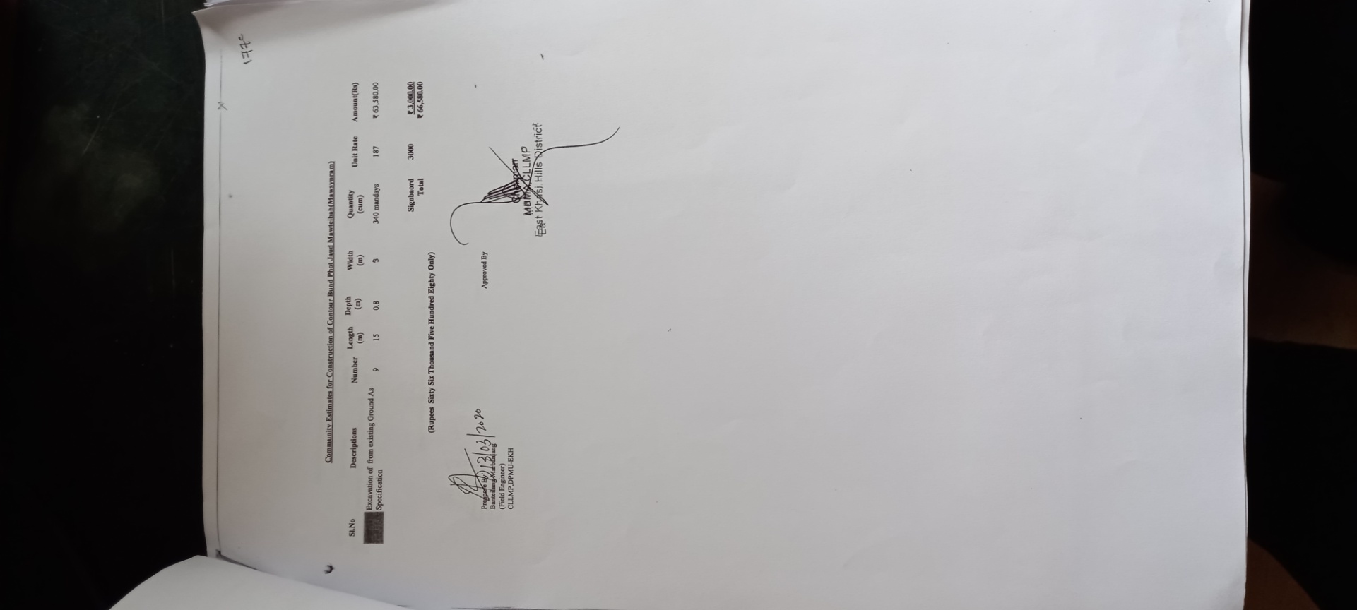
Project officials from the DPMU made an inspection to the proposed intervention sites of the CNRMP (Spring Chamber and RCC Check dam) and the Field Engineer from the DPMU made recommendations based on the wants of the village.
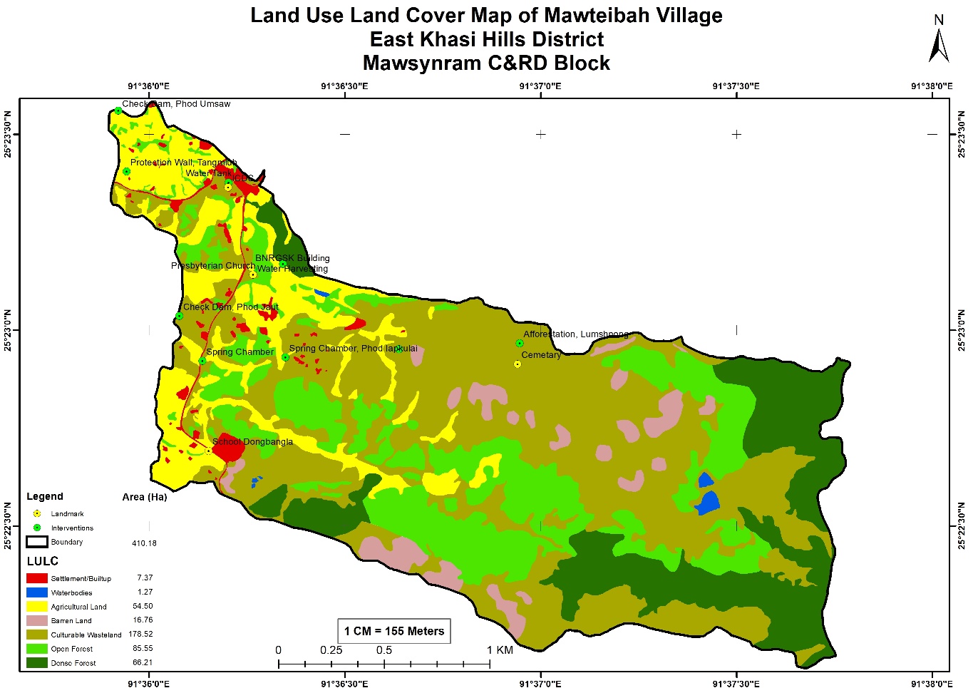
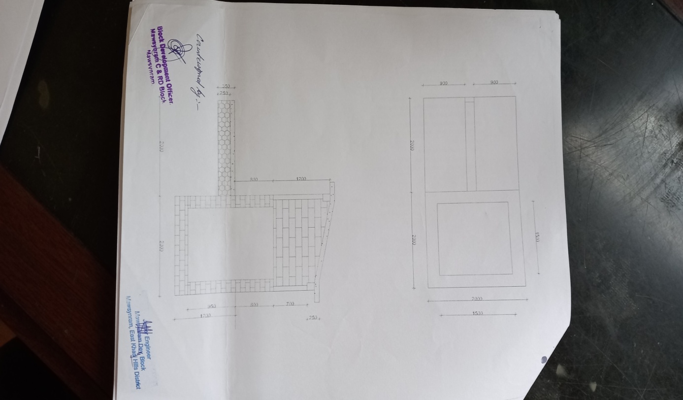
Maps:
| 1 | Type Of Intervention | Site Name | GPS Co-ordinates | Amount Sanctioned | Work Status | |
|---|---|---|---|---|---|---|
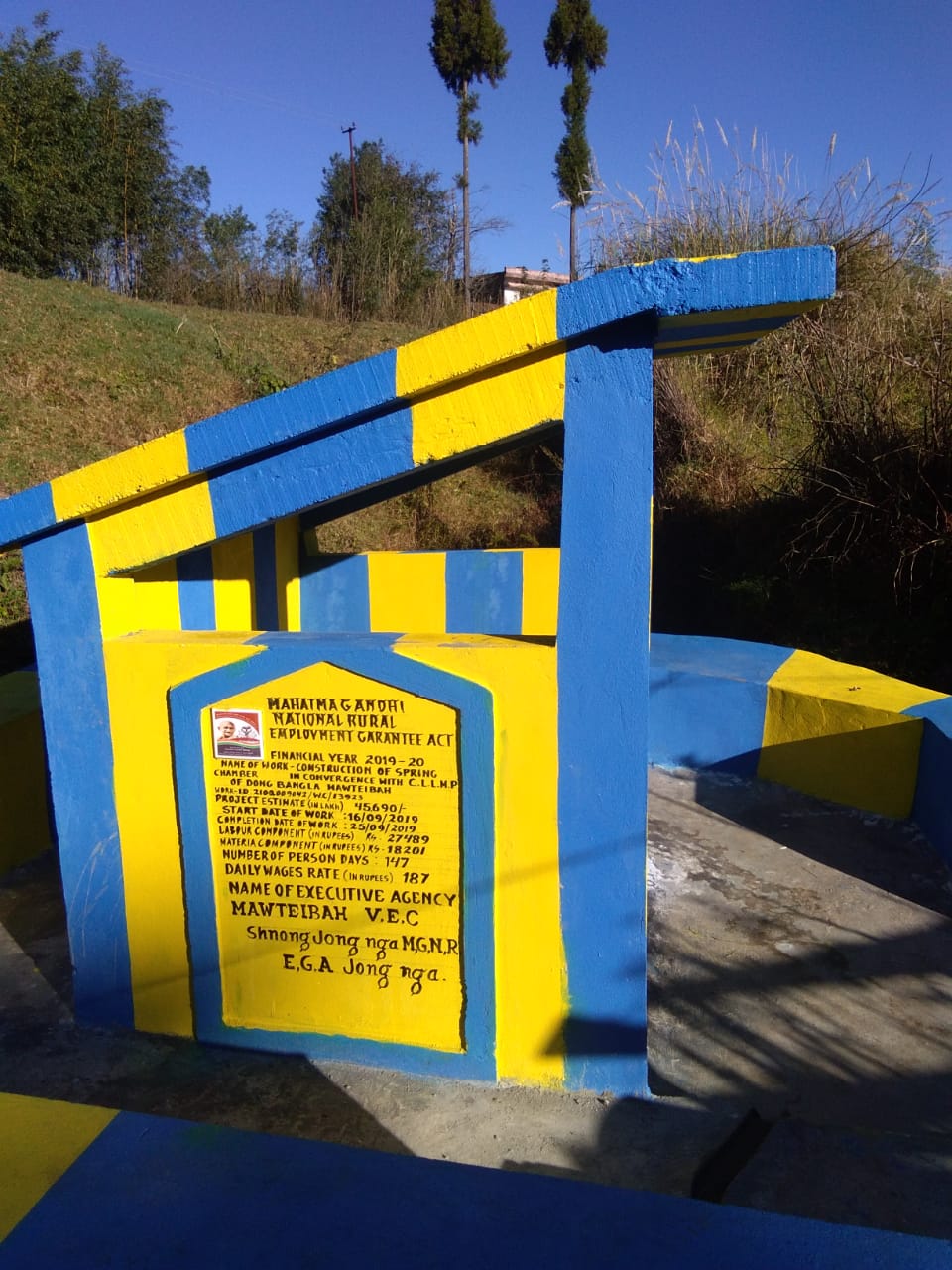
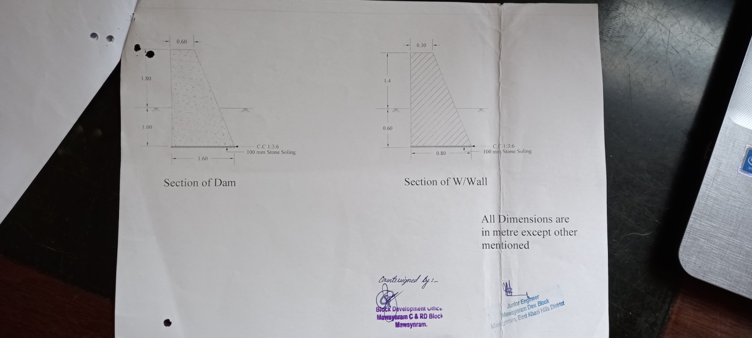
| Spring Chamber | Dong Bangla | 25°38'56.02"N | 91°60'62.02"E | ₹45,690 | Completed | |
| 2 | Type Of Intervention | Site Name | GPS Co-ordinates | Amount Sanctioned | Work Status | |
|---|---|---|---|---|---|---|
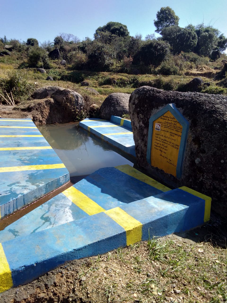
| RCC Check Dam | Phot Umksiar | 25°37'83.09"N | 91°62'03.09"E | ₹169,270 | Completed | |
Community Natural Resource Management Plan Template
VILLAGE SUMMARY
| District: EKH Block: Mawsynram Village:Mawteibah | |
|---|---|
| Postal Address: Mawsynram PIN: 793113 | |
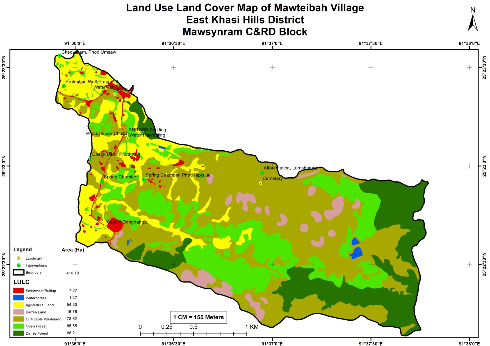
VILLAGE GIS MAP (Baseline Land use land cover map of village to be prepared using information from GIS Atlas and Google Earth as a first step before community mobilisation in the village)
| Sl. No. | Parameters (sl.no.1&2 to be filled by GIS Expert) | Village Information | ||||||
|---|---|---|---|---|---|---|---|---|
| 1 | GPS Coordinates: | |||||||
| i | Latitude | 25.38941˚ | ||||||
| ii | Longitude | 91.60337 ˚ | ||||||
| iii | Elevation Reading (MSL) | 1676 m | ||||||
| 2 | Village Geographical Area (Ha) | Total: 410.18 Ha 4.1018 sq. Km | ||||||
| i | Total Forest Area (including community, Clan, Pvt Forest) | 151.76 Ha | ||||||
| ii | Total Area of Water Bodies | 1.27 Ha | ||||||
| iii | Total Area under Agri-Horticulture | 54.5 Ha | ||||||
| iv | Total Degraded land area (Ha) | 16.76 Ha | ||||||
| 3 | Average Annual Rainfall (data to be collected from secondary data by DPMU at district/block level and need not be village level) | mm | ||||||
| 4 | Soil Type(data to be collected from secondary data by DPMU) | |||||||
| 1.2 VILLAGE SUMMARY SHEET | ||||||||||||||||||
|---|---|---|---|---|---|---|---|---|---|---|---|---|---|---|---|---|---|---|
| Sl. No. | Parameters | Village Information | ||||||||||||||||
| 1 | Traditional Land tenure system (Hima /Raid/ /Doloiship/sirdarship/Nokmaakingetc) | Maharam Syiemship | ||||||||||||||||
| 2 | Distance from Block HQ (Km) | 20 Km | ||||||||||||||||
| 3 | Distance from District HQ(Km) | 52 Km | ||||||||||||||||
| 4 | Community inhabiting the village (Khasi, jaintia, Garo & Others) | Khasi | ||||||||||||||||
| 5 | No of HHs in the village | 141 | ||||||||||||||||
| 6 | Total population | 928 | ||||||||||||||||
| 7 | Demographic | M | F | Total | ||||||||||||||
| i | 0-4 | 58 | 47 | 105 | ||||||||||||||
| ii | 5-14 | 152 | 86 | 238 | ||||||||||||||
| iii | 15-30 | 136 | 96 | 310 | ||||||||||||||
| iv | 30-60 | 161 | 109 | 270 | ||||||||||||||
| v | Above 60 | 28 | 55 | 83 | ||||||||||||||
| 8 | Major occupations of people in the village (in order of importance). (Collect only one major occupation per HH. The Number of all occupation should be equal to total no.of HH in the village.) | |||||||||||||||||
| Occupations | HHs | |||||||||||||||||
| i | Agriculture and Labourer | 133 | ||||||||||||||||
| ii | Teachers | 7 | ||||||||||||||||
| iii | Govt Servant | 1 | ||||||||||||||||
| iv | ||||||||||||||||||
| v | ||||||||||||||||||
| vi | ||||||||||||||||||
| 9 | Public Transport Facilities to & from village Yes/No:…if yes (specify) | i. Local Taxi | ||||||||||||||||
| ii. Bus | ||||||||||||||||||
| iii. Sumo | ||||||||||||||||||
| iv. | ||||||||||||||||||
| 10 | Energy fuel use by HHs | No of HH | Qty (Kg/HH) | Total | ||||||||||||||
| i | Charcoal | 1 | 730 | 730 | ||||||||||||||
| ii | Wood | 0 | 0 | 0 | ||||||||||||||
| iii | LPG | 140 | 1,460 | 2,04,400 | ||||||||||||||
| iv | Kerosene | |||||||||||||||||
| v | Electricity | |||||||||||||||||
| 11 | Does the village have sites of Tourist interest | Yes | ||||||||||||||||
| If Yes mention the site & No of Tourist | NA | |||||||||||||||||
| i | ||||||||||||||||||
| ii | ||||||||||||||||||
| iii | ||||||||||||||||||
| 12 | Number of Village Institution with their status | |||||||||||||||||
| Village Council/ VEC/Traditional Institutions | ||||||||||||||||||
| Water and Sanitation Committee | ||||||||||||||||||
| Self Help Group for Livelihood Activities | ||||||||||||||||||
| Other if any | ||||||||||||||||||
| 13 | Availability of Govt. Water Supply (Y/N) | |||||||||||||||||
2.1 Traditional Village Institutional Functionaries (Village Dorbar/Nokma/Doloi Council) |
|||||||||||
|---|---|---|---|---|---|---|---|---|---|---|---|
| Sl No | Name in Full | Gender M/F | Age (in Yrs) | Education | Designation | Occupation | Community | Contact No and email address | |||
| 1 | Hastingwell.K Hari | Male | 54 | Class 2 | Headman | Teacher | Khasi | ||||
| 2 | Pynshaibor K. Synteng | Male | 44 | XII | Secretary | Teacher | Khasi | ||||
| 3 | Khrawkupar Mawlong | Male | 24 | x | member | Farmer | Khasi | ||||
| 4 | Der War | Male | 52 | Class 3 | member | Farmer | Khasi | ||||
| 5 | Arten Wahlang | Male | 43 | Class1 | member | Farmer | Khasi | ||||
| 6 | John Singh | Male | 32 | XII | member | Farmer | Khasi | 6001167496 | |||
| 7 | Hunlang Lyngkhoi | Male | 45 | Class 4 | member | Farmer | Khasi | ||||
| 8 | Sharningstar Hynniewta | Male | 45 | x | member | Farmer | Khasi | ||||
| 9 | Drod Mawlong | Male | 30 43 |
Class 4 | member | Farmer | Khasi | ||||
| 10 | Dimaket Kharbani | Male | 43 | Primary | member | Farmer | Khasi | ||||
| 11 | Deberud Mawlong | Male | 44 | Primary | member | Farmer | Khasi | ||||
| 12 | Serious Riwah | Male | 47 | Primary | member | Farmer | Khasi | ||||
| 13 | Shanlang K. War | Male | 30 | Primary | member | Farmer | Khasi | ||||
| 14 | Wellbornstar Lyngdoh | Male | 37 | Master Degree | member | Farmer | Khasi | ||||
|
||||||||||||
| Sl No | Name in Full | Gender M/F | Age (in Yrs) | Education | Designation | Occupation | Community | Contact No and email address | ||||
| 1 | Sharningstar Hynniewta | Male | 45 | vii | Chairman | Farmer | Khasi | |||||
| 2 | Sorti Shanpru | Female | 36 | x | Secretary | Aganwadi Helper | Khasi | |||||
| 3 | John Sing Lyngdoh | Male | 32 | xii | Treasurer | Farmer | Khasi | 6001167496 | ||||
| 4 | Demarket Kharbani | Male | 43 | Primary | member | Farmer | Khasi | |||||
| 5 | Der War | Male | 52 | Class 3 | member | Farmer | Khasi | |||||
| 6 | Arten Wahlang | Male | 43 | Class1 | member | Farmer | Khasi | |||||
| 7 | Drut Mawlong | Male | 39 | iii | member | Farmer | Khasi | |||||
| 8 | Dira Mawlong | Female | 42 | BA | member | teacher | Khasi | |||||
| 9 | Delir Lyngdoh | Female | 42 | iii | member | labourer | Khasi | |||||
| 10 | Misharna Mawlong | Female | 35 | vii | member | labourer | Khasi | |||||
2.3 Green Facilitators
| Sl No | Name in Full | Gender M/F | Age (Yrs) |
Education | Area of specialisation/ focus (forests, water, soil, accounts, environmental and social safeguards, knowledge management, GIS) | Trained under CLLMP (Yes/ No?) if Yes, date training was received | Contact No and email address |
|---|---|---|---|---|---|---|---|
| 1 | Johnsing Lyngdoh | M | 32 | xii (Farmer) | Forest | 6001167496 | |
| 2 | Khrawkupar Mawlong | M | 24 | x (Farmer) | Soil | ||
| 3 | Sorti Shanpru | F | 36 | xii (Aganwadi Worker) | Water | No |
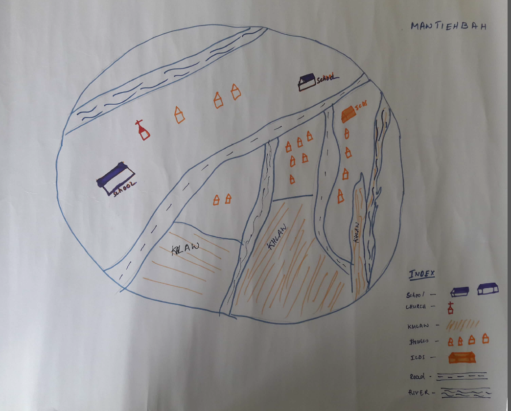
| 1 | The exercise should be done in a public place, that all members of the community, can access and participate in; |
|---|---|
| 2 | Facilitators should carry GIS map of village/ Google Earth Map |
| 3 | Introduction on Resource Map to the community; entire community to be present |
| 4 | Facilitate the community to draw the Village Resource Map of the village on the floor/open ground/Chart Paper using participatory tools and locally available materials |
| 5 | Facilitate community to draw village Boundary-basic landmarks such as roads streams, rivers, forests, agricultural land etc |
| 6 | Map out details of land use such as Community forest, clan forest, Pvt individual forest, Jhum area, important cash crop areas, Agriculture areas, Agro forestry, degraded land area, sand/stone quarries, coal mining areas, steep slope areas, low land areas, wasteland & Plant species in each forest type etc. |
| 7 | Map out details of water bodies such as springs &springshed, water catchment areas, ponds, lakes, water reservoirs, sites for fishing etc & Temporary features (Seasonal ponds/Lakes) etc |
| 8 | Briefing and validation of the Resource Map with the community. Copy the Resource Map on the paper for official record. Use Standard legends for uniformity and convenience. |
| 9 | Ensure that participants engaged in drawing Resource maps including VNRM committee sign and date at the back of the Resource Map and it is endorsed by the head of the village council |
| 10 | It is recommended that the group prepare two copies of Resource Maps, so that one copy may be given to the community for their future reference. Take a photo |
RESOURCE MAPPING
(This is the tool to begin interaction with the people in the village. This exercise will provide an opportunity to bring people together to understand the natural resources of the village towards plan preparation. The facilitators must have the secondary information in advance to be able to facilitate effectively; The information collected through this process should be filled into the template provided for Land Use Pattern.)
4. LAND USE PATTERN
| Sl No | Land use Category | Land Ownership (Community/Clan /Pvt individual etc) |
Name of the Site |
Quality of forest(Dense, Moderate, open) refer to GIS Map | Land Area /stretch as in the vilage (Ha/Km) |
Present Uses/Benefits HHs=1; Timber =2; NTFP =3; Fuelwood = 4; Medicine & Aromatic plants=5, Others=6 |
Land Area available for intervention (Ha) | Grazing (Y/N) |
Remarks |
|---|---|---|---|---|---|---|---|---|---|
| 4.1 | Forest (Specify type)(total area of all forest should match with forest area of the village measured under GIS) | ||||||||
| Community Forest (Lawshnong/SongniBirungbolgrik) |
|
|
|
|
|
|
|||
| Private (Rikynti/) |
|
|
|
|
|
|
Many Small Private Forest Holding are there | ||
| Clan Forest (Lawkur/Maharini/ Raid |
|
|
|
|
|
|
No Clan Forest | ||
| Protected Forests/ Green Blocks (including Law Adong and Law shnong, forests protected for aesthetic reasons) |
|
|
|
|
|
Cut trees for the funeral purspose | |||
| Catchment Areas (water supply) (Area to be filled by GIS) |
|
|
|
|
|
|
| SL. No. | Land use Category | Land Ownership (Community/Pvt individual etc) |
Name of the Site |
Land Area available for intervention (Ha) | Source of Seeds Community Nursery=1 Purchase=2 Others=3 |
Use of Organic Fertilser/Bio-Pesticide/Bio-Insecticides etc. (Y/N) |
Remarks |
|---|---|---|---|---|---|---|---|
| 4.2 | Cultivable Land (Area in ha to be filled by GIS) | (To be filled by DPMU team) | (To be filled by DPMU team) | ||||
| 1 | Area under Agriculture (Mention Ha under each crop – Paddy, Maize others) wet land (Paddy Field) | 1. Private (all Paddy) | 1. Umkyrnem 2. Umlawbah 3. Wah Mawpon 4. Phod Jaud |
NA | Check Dam at Umsaw and Phod Jaut will irrigate 10 Ha of cultivable Land | ||
| 2 | Area under Horticulture (Mention Ha under each type) |
NA | NA | NA | NA | NA | No Horticulture in the village |
| 3 | Area under Cash Crops 1 (Specify) | Private | 1. Umkyrnem 2. Umlawbah 3. Wah Mawpon |
NA | NA | Check Dam at Umsaw and Phod Jaut will irrigate 10 Ha of cultivable Land | |
| 4 | Area under Cash Crops 2 (Specify)…… ) | NA | NA | NA | NA | NA | NA |
| 5 | Area under Shifting Cultivation Average cycle (yrs)………………… | Private | 1. Mawsawa 2. Dom Mawsawa 3. Remsohsat |
NA | NA | ||
| 6 | Culturable Wasteland(to be filled by GIS ) | Community & Private | 1. Sain Ngap 2. Phot Jaud |
NA | NA | NA | Suggested to take up new intervention at the culturable wasteland on the catchment area |
| SL. No. | Land use Category | Ownership/Community/Private | Name of the water body/spring |
GPS coordinates (to be filled by technical team) | No of Dependent HH (to be filled by social survey team) | Nature of water body (Perennial/Seasonal) (to be filled by technical team) | Existing Soil & Water Conservation structures (to be filled by technical team) |
Water quality tested (Y/N) (to be filled by technical team) |
Size/length of River /stream (Ha/Km) (length of river, stream, to be provided by GIS) |
Present use/Benefit (fisheries/irrigation/drinking water) (to be filled by social survey team) |
Number/Area available for intervention (to be filled by technical team) |
Remarks (to be filled by DPMU) |
|---|---|---|---|---|---|---|---|---|---|---|---|---|
| 4.3 | Water Bodies (specify) | |||||||||||
| 1 | Springs/Water Source | community | 1. Mawsawa 11. Phod Jahkulai 12. MawliteM |
1. 2. 3. 4. 5. 6. 7. 8. 9. 10. 11. 25.38215°N, 91.60582°E 12. |
1. 2. 3. 4. 5. 6. 7. 8. 9. 10. 11. 12. |
1. 2. 3. 4. 5. 6. 7. 8. 9. 10. 11. Perennial 12. |
1. 2. 3. 4. 5. 6. 7. 8. 9. 10. 11. Y 12. |
1. 2. 3. 4. 5. 6. 7. 8. 9. 10. 11. Y 12. |
1. 2. 3. 4. 5. 6. 7. 8. 9. 10. 11. Drinking & Cooking 12. |
Land are owned by the private party but the springs are belonging to the community | ||
| 2 | Natural ponds | No Natural Pond | ||||||||||
| 3 | Lakes | No Lake | ||||||||||
| 4 | Streams within village area | community | 1. Wah Umlawbah 2. Phod Weisyiang 3. Phod Thaidsngi 4. Phod Umkynrem |
1. 2.30 Km 2. 1.60 Km 3. 2.80 Km 4. 0.50 Km |
Drinking & irrigation | |||||||
| 5 | Rivers within Village Geographical area | No River within the boundary of the village | ||||||||||
| 6 | Others (Specify) |
| 4.4 | Indigenous/ Cultivated Trees and NTFPs in Forests | List of Species | Main use (Household/ Commercial) |
|---|---|---|---|
| 1 | Indigenous Tree species in Forest | Dieng Doh, Dieng Sai, Dieng Ngan, Dieng Ri, Sohphie, Sohot, Dieng Loin, Dien Pei, Dieng Rai, Dieng Snoin, Soh Tyrnem | Timber, Fuelwood |
| 2 | NTFPs in Forest including medicinal shrubs/trees etc | Bat Sohleh, Jutira, Dieng Siasia, Jajew, Bat Proh, Soh Bsein, Soh Khtein, Tangtohdia, Syreng Khla, Loingniang | Medicinal use |
| 3 | Commercially valued Trees/ Shrubs/Plants in forests/ | Langniang, Sohbsein, Bat jatung | Timber |
| 4 | Fodder Species/ Valuable grasses in forests | Phlang Tylli, Phlang Saw, Long prut, Sla Soh, Kynmeh, Sla lapoitdong | Fodder |
| 5 | Any vulnerable/ endangered species in Forest (fauna & flora) | Rabbit, IarKhlaw, Lathap Sim | |
| 6 | Invasive plant Species (if any) | Dieng Kseh |
5. PROBLEM ANALYSIS
(These are some questions to facilitate FGDs to get an understanding on the challenges and concerns in the village. Some of the issues could be Soil degradation/erosion; Forest Fires; Unscientific Mining; Deforestation; Degraded Jhum Lands; Waste/Pollution; Mining runoff; Siltation; Over- extraction. This information will help fill the form 5.1, 5.2, 5.3 and 5.4. The information can be collected in advance or substantiated later with the help of secondary sources. The interaction should take place as a discussion and the forms should be filled after the discussion, and not during it)
Do people have sufficient access to supply of fodder, fuel wood, leaf litter?
Yes, there is sufficient amount in the supply of fodder and fuel wood.
Has access to timber improved or reduced over the years? How is access for household use and commercial use managed?
The access to timber has been reduced over the years because of certain community laws to protect the forest and also to prevent the people from outside the village from cutting down the trees from the community forest. Even though the cutting down of trees has been reduced for fuel wood, the amount that they got is sufficient. If not, some usually buy fuel wood from outside the village at a cost of ₹3000 per pickup.
Are the water bodies facing any threats?
At present the water bodies in the village haven’t face any threats. Even though, no cases have been reported, there are some potential threats that could affect the water bodies in the future i.e. chemicals used for crops that usually flows down the rivers especially during rainy seasons.
Do all people in the village have access to drinking water? What are the challenges?
Yes, all the people receive and have access to drinking water, but the only challenges that the people faced is water scarcity during winter season, particularly in the month of February to March. The scarcity of water during this season, has led the people to resort water from neighbouring village or travel around one and half kilometres from their village to access drinking water.
Are there degraded areas in the village (open/ degraded forests, mining affected, high soil erosion etc.)?
No.
What has caused this degradation? Are there practices causing threats to availability and access to natural resources?
So far no lands or forest are degraded but, there is a potential threat which could degrade the lands and forest i.e. forest fire caused by human actions.
What have been the changes in agricultural practices?
No, there have been no changes in the agricultural practices, people have been following traditional methods and practices since ages.
Are there any challenges in farming?
Climate change is the only threat and challenge faced in farming. Because of climate change, sometimes there is less rainfall and sometimes there is heavy rainfall that destroy the crops.
How would you consider the health situation in your village?
Poor, because of the lack of health facilities. Even in the village’s CHC there are no doctors and nurses and for any mild sicknesses people usually go to the neighbouring CHCs at Mawphlang and Mawsynram, but for major check-up like pregnancy and child birth the people usually go all the way to Shillong, Lawmali. The irregularity and the lack of doctors and nurses in the village has created a lot of problems as the people had to travelled a lot of miles for any medical cases which to them is time consuming and loss of money.
How is the situation of cleanliness, sanitation, access to toilets and waste management?
Good. Plastics and the burning of waste are banned in the village, plastic bottles and other forms of plastic waste are managed by the SBM. Other organic waste are being turned and used as fertilizers.
Who are the most vulnerable in the village? What can be done to improve their lives?
The most vulnerable groups in the village are:
The physically impaired.
The old age
Women and
Widows
In helping the vulnerable groups, the village helps them in applying various pension schemes.
What are the livelihood aspirations of the youth? Are there any avenues available?
Most of the youth’s livelihood aspirations is working as a daily labourer. No avenues are available in the village but they also do rely on Govt. schemes.
Do any committees/ institutions/ rules exist to manage and monitor natural resources in the village?
Yes, village rules and regulation in protecting the forest exist in order to monitor and manage the natural resources. During environment day the village as a whole took part in the process of planting trees (afforestation) led by the village committee. The women’s wing also organise cleaning drive in the village and planning and making of fire lines are being done by men from the village. There is a diverse division of labour in protecting the forest in the village.
What are some of the major issues of conflict in the village?
There are no major issues in the village except land disputes but some issues such as the environmental issues, cleanliness are always being discussed and addressed during village Dorbar.
Have any of the above issues been discussed in village meetings?
Yes
How do people resolve disagreements and conflicts?
If it can still be manage by the village, disputes are being handle by the village Dorbar but if things escalates beyond compromise the village community let the police handle the issues.
| 5.1 | Land | ||||||||
|---|---|---|---|---|---|---|---|---|---|
| Sl No | Category of Land/Water Body |
Soil degradation/erosion (in Ha) (DPMU to collect from secondary data) |
Forest Fires (in Ha) | Un scientific Mining (in Ha) |
Deforestation (in Ha) (To be filled by GIS) |
Degraded Jhum Lands (in Ha) | Others (in Ha) | Total Area Affected (approx. in Ha) |
Remarks |
| 1 | Land | ||||||||
| A | Forest | No | No | No | 10 | 8 | 10 | Jhum cultivation is mostly in the deforested area | |
| B | Cultivable land | No | No | No | No | No | Soil Erosion mostly along the river bank cultivated area | ||
| C | Others (Specify) | ||||||||
| 5.2 | Water Bodies Affected | ||||||||||
|---|---|---|---|---|---|---|---|---|---|---|---|
| Sl No | Category of Land/Water Body | Number affected & Name of sites | Waste/ Pollution | Mining runoff | Siltation of water bodies | Over- extraction | Deforestation in Catchment | Test Result? (attach) | Others (Specify)
|
||
| Solid Waste | Domestic waste water | ||||||||||
| 2 | Water Bodies | ||||||||||
| A | Springs (name of springs) | 1. Mawsawa 2. Mawpun 3. Umsaw 4. Tangmluh 5. Mawjnoin A 6. Mawjnoin B |
No | No | No | No | No | NO | No | ||
| B | Stream (number) | 1. Wah Umlawbah 2. Phod Weisyiang 3. Phod Thaidsngi 4. Phod Umkynrem |
No | No | No | No | No | No | No | ||
| C | River/ pond/ lake | ||||||||||
| 5.3 | Disputes / Constraints encountered by Community | |||||
|---|---|---|---|---|---|---|
| Sl No | Type of Resource | Dispute (mention if within village=1 or with other village/s =2) | Constraint | Rating/Frequency/ Number of Months in the year | Proposed resolution | Priority (can be addressed through CNRM plan) |
| 1 | Village Geographical Boundary | No | No | NA | NA | NA |
| 2 | Drinking Water | No | yes | Jan- April | yes | |
| 3 | Water for irrigation | No | No | NA | NA | NA |
| 4 | Access to land for construction of House | No | No | NA | NA | NA |
| 5 | Access of land for cultivation | No | No | NA | NA | NA |
| 6 | Access to timber for construction etc | No | No | NA | NA | NA |
| 7 | Access to NTFP (Wild vegetables, canes and bamboo, lac, Herbal medicines etc) | No | No | NA | NA | NA |
| 8 | Access to Fodder | No | No | NA | NA | NA |
| 9 | Access to Fuel wood | No | No | NA | NA | NA |
| 10 | Access to LPG | No | No | NA | NA | NA |
| 11 | Access to solar cookers/ heaters | No | No | NA | NA | NA |
| 12 | Access to Food/PDS | No | No | NA | NA | NA |
| 13 | Others (Specify) | No | No | NA | NA | NA |
| 5.4 | VILLAGE GOVERNANCE/ MANAGEMENT OF ENVIRONMENT AND NATURAL RESOURCE |
|---|
| Sl No | Environment Parameters | Rules & Management System In Place in Village Yes =1; No = 2; Not Applicable (NA)=3 |
Management Committee/Volunteers in place (Y/N and Composition) |
Contact Person and contact Details | ||
|---|---|---|---|---|---|---|
| Y/N | No of M | No of F | ||||
| 1 | Access for timber/NTFPs etc from community forest | 2 | NA | NA | NA | NA |
| 2 | Access for cultivable land for villagers from community land | 2 | NA | NA | NA | NA |
| 3 | Protection of spring sheds, water sources | 2 | NA | NA | NA | NA |
| 4 | Protection of catchment areas | 2 | NA | NA | NA | NA |
| 5 | Prevention of forest fires | 2 | NA | NA | NA | NA |
| 6 | Conservation of aquatic life in rivers, streams etc | 2 | NA | NA | NA | NA |
| 7 | System for Disposal of solid waste | 2 | NA | NA | NA | NA |
| 8 | System for treatment of Household affluent | 2 | NA | NA | NA | NA |
| 9 | Cleanliness of village - roads, footpaths | 2 | NA | NA | NA | NA |
| 10 | Social fencing for Protection of stray cattle/other domestic animals | 2 | NA | NA | NA | NA |
| 11 | Participation of women in decision making at various platforms | 2 | NA | NA | NA | NA |
| 12 | Rate of wages for both men and women for different types of labour | 2 | NA | NA | NA | NA |
| 13 | Ensuring survival of young plantations (upto 5 years) | 2 | NA | NA | NA | NA |
| 14 | Management of afforested plots | 2 | NA | NA | NA | NA |
| 15 | Eco-Tourism | 2 | NA | NA | NA | NA |
| 16 | Others (Specify) | 2 | NA | NA | NA | NA |
6. CNRM PLAN PREPARATION
The idea is to create a positive environment where the people discuss problems but with a target of solving them, moving to a higher goal, identifying that goal and a collective vision.
There are many ways of facilitating a visioning exercise. If the group is very large then they can be broken into smaller groups, if the group is small, then questions can be posed for each individual. Based on small group discussions or individual map a depiction of what the village would be ten years from now can be prepared. Facilitators should aim to break the ice and help the group think about their vision. Make the exercise fun by asking “if you had a magic wand what would you change” or “if you had one wish what would you do for your village”. There is no harm in starting from personal aspiration- ask parents what they want for their children or ask youth what their aspirations are.
Each small group or individual can be given a topic/area: forests, agriculture, water, school, health, transport, livelihood, tourism and so on. They can be asked to discuss the problem today that needs to be solved and what they see in this area ten years from now. Based on the discussion or reflection, a combined chart can be prepared the issues can be written and another chart where the vision/desire/wish/goal can be written for each area. This process helps people to think holistically and not see the project as a source of a few activities.
This vision chart can be a basis to start the next set of discussion, on prioritization of interventions and be a reference document to help plan under the project.
6.2 Prioritization Exercise
The exercise should build on the resource map and baseline information collected to arrive at potential interventions and initiatives the community would like to plan to achieve their vision for improvements in the state of natural resources of their village.
Group Discussion - Groups of different age groups such as youth men, youth women, men above 30, women above 30 years old.
Facilitate each group to discuss the pressures and challenges related to natural resources in the village, existing best practices and knowledge within the village and then envision improvements that could enhance the state of natural resources and contribute to an improved resource base.
Facilitate them to prioritize new interventions and initiatives to achieve these improvements. Map out the proposed interventions and initiatives using the resource map and write up the interventions in a tabular format
Copy the Vision map on paper for purpose of record and attach the group discussion points of different groups. The list of participants of each group may be attached for future reference.
Geo-tag intervention sites, take photos of sites during the planning stage to compare through the cycle of intervention.
6.3 Intervention identification
| Area of Intervention | Intervention 1 | Intervention 2 | Intervention 3 | Intervention 4 | Intervention 5 | Intervention 6 | Intervention 7 | Intervention 8 | Intervention 9 | Intervention 10 | Intervention 11 | Remark on any traditional knowledge/ best practice within the village |
| Activity/ Site | Activity/ Site | Activity/ Site | Activity/ Site | Activity/ Site | Activity/ Site | Activity/ Site | Activity/ Site | Activity/ Site | Activity/ Site | Activity/ Site | ||
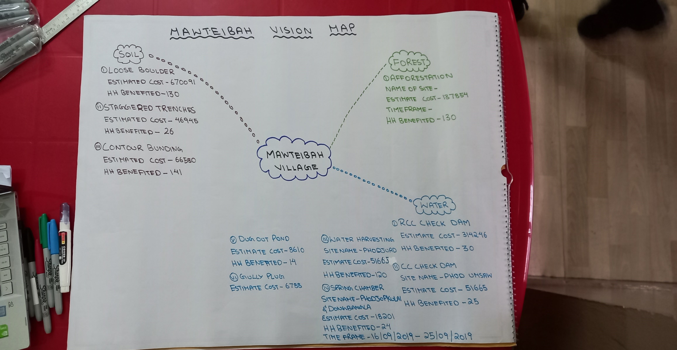
| Soil and Water Conservation | Check Dam/ Phod Umsaw | NA | NA | Dugout Pond (2)/ Phod Jaut | NA | Contour Trenches/Phod Jaud | Water Harvesting Structure (2)/ Phod Jaud | Loose Boulder Bund (5)/ Phod Jaud | Check Dam/ Mawpon | NA | NA | |
| Land Productivity Enhancement | NA | NA | NA | NA | NA | NA | Na | NA | NA | NA | NA | |
| Spring Shed Management | NA | Spring Chamber/ Dong bangla | Spring Chamber / Phod Jopkulai | NA | NA | NA | NA | NA | NA | NA | NA | |
| Afforestation/ Community Forestry Activities | NA | NA | NA | NA | NA | NA | NA | NA | NA | Community Nursery/ Mawkynshait | Afforestation/ Lum Shnong | |
| Capacity Building | NA | NA | NA | NA | NA | NA | NA | NA | NA | NA | NA | |
| Others | NA | NA | NA | NA | NA | NA | NA | NA | NA | NA | NA | |
*Note: Consider following criteria for prioritizing the water sources for intervention:
a) Number of dependent households b) Discharge level c) Demand vs Supply Gap d) Drastic change in discharge e) Availability of Land for intervention f) Willingness of communities/individuals
For prioritized springs, fill and attach Annexure-B (Spring Information Form)
|
Name of Proposed Interventions | Site |
|
Nos of HHs expected to Benefit | Priority (High/ Medium/ Low) | Start date (MM/YY) | Completion date (MM/YY) | ||
|---|---|---|---|---|---|---|---|---|---|
|
|
|
|||||||
| 1 | Check Dam | Phod Umsaw |
|
|
|
|
High | ||
| 2 | Spring Chamber | Dong Bangla |
|
|
|
|
High | ||
| 3 |
|
Phod Jopkulai |
|
|
|
|
High | ||
| 4 |
|
Phod Jaud |
|
|
|
|
High | ||
| 5 |
|
Phod Jaud |
|
|
|
|
High | ||
| 6 |
|
Phod Jaud&Jopkulai |
|
|
|
|
High | ||
| 7 |
|
Phod Jaud |
|
|
|
|
High | ||
| 8 |
|
Mawpon |
|
|
|
|
High | ||
| 9 |
|
Mawkynshait |
|
|
|
|
High | ||
| 10 |
|
Lum Shnong |
|
|
|
|
High | ||
6.5Training and Capacity Building for implementing CNRM Plan
Sl
|
Type of Training/ Cap Building Activity | No of People | Target audience (VCF/VNRMC) | Proposed frequency | Remarks | ||
|---|---|---|---|---|---|---|---|
| 1 | Training on Solid Waste Management | ||||||
| 2 | Training on Gender inclusion | ||||||
| 3 | Training on Landscape Management | ||||||
| 4 | Social Management and Community Mobilization | ||||||
| 5 | Soil and Water Conservation | ||||||
| 6 | Land Productivity Enhancement | ||||||
| 7 | Forestry and Agroforestry | ||||||
| 8 | Community Nursery and Nursery Management | ||||||
| 9 | Spring Shed Management and Development | ||||||
| 10 | Other training required (please specify) | ||||||
6.6 ENVIRONMENT ELIGIBILITY SCREENING
| Sl. No | Activities/Subprojects with any of the attributes listed below will be ineligible for support under the proposed project due to environmental implications. | Yes/No |
|---|---|---|
| 1 | Any subproject/activities that is not consistent with Acts of GoI and GoM | No |
| 2 | Subproject/activities that could intervene or damage/fragment and/or adversely affect/ impact natural habitats/ protected areas, reserve forests, including but not limited to, the following sites:
|
No |
| 3 | Subproject/activities that support forest harvesting on a large/industrial scale | No |
| 4 | Activity that involves construction of check dam >3m height | No |
| 5 | Subprojects/activities that promote or require pesticides that falls in WHO classes IA, IB, or II and/or procurement of large amount of pesticides or toxic agro-chemicals. | No |
| 6 | Subprojects/activities will not support large- scale clearing of land, dredging of water bodies, undercutting of slopes, replacement of natural vegetation that may cause permanent, irreversible impacts. | No |
| 7 | Any activity that has a significant potential of causing forest fires | No |
| 8 | Any project activity that leads to large-scale soil erosion and siltation of water bodies | No |
| 9 | Any activity that promotes or involves incidence of child labour. | No |
| 10 | Sub project/Activities that would adversely affect cultural sites, places of significance importance and protected historical assets (both living and built) | No |
| 11 | Sub project/Activities that involves the felling of the ‘prohibited trees’ without a permit | No |
| 12 | Sub project/Activities that seeks to impose restrictions or loss of access to using natural resources, including medicinal plants or those of economic value for livelihoods. | No |
| 13 | Any activities involving use of Asbestos Containing Materials (e.g. Pipes for community irrigation schemes). | No |
If Yes- reject /modify activities in the plan to meet the criteria.
6.7 ENVIRONMENTAL REGULATORY COMPLIANCE SCREENING
If the answer to the questions posed in the screening process below is ‘Yes’, mitigation measures would be required to be put in place.
| S. No. | Regulatory requirements | Implications for project | |
|---|---|---|---|
| I | Are any of the activities located within a notified Eco Sensitive Zone (ESZ)?
If yes, Are any of the activities on the list of activities regulated in ESZ? If yes, Has the required permission been taken? |
No |
|
II III |
Are any of the activities involving construction located between 100-300 meters from an archaeological site/monument. If yes, has permission been taken from the Archaeological Survey of India? |
No | Follow EGs on Chance find procedures |
IV V |
Do any of the activities require license under the Fertilizer Order 1985 (selling, stocking, exhibiting for sale or distribution of bio-fertilizers and organic fertilizers)? If yes, has the license been taken? |
No | Follow General Rules under Fertilizer Order 19851 |
6.8 Social Screening Checklist
LAND MANAGEMENT2
| Screening Questions | Yes | No | Details/Remarks | |
|---|---|---|---|---|
| 1. | Is there land requirement under each proposed intervention? | Yes | What is the size of land required per intervention? Who owns the land (Community, Clan or Private) |
|
| 2. | Does the land selected ensure minimum adverse impact? | No | ||
| 3. | Is there any impact on: | Provide number of affected persons per intervention | ||
| Agricultural land | ||||
| Forest land | ||||
| Access to common resource (mention type of resource) | ||||
| 4. | Are the estimated affected persons from the vulnerable category? | No | Provide number of affected persons per intervention | |
| Women headed HH | ||||
| BPL HH | No | |||
| 5. | Will land be taken on voluntary land donation? | No | ||
| 6. | Have the principles and procedures3 for voluntary land donation been duly followed? | |||
| 7. | Have due precautions been taken to minimize disturbance to sensitive locations or locations having cultural significance? |
SOCIAL INCLUSION4
| Screening Questions | Yes | No | Details/Remarks | |
|---|---|---|---|---|
| 1. | Was separate consultation held with different groups? | Mention type of interaction and location | ||
| Women | Yes | |||
| Youth | ||||
| Low income families | ||||
| Minority groups | ||||
| Any other | ||||
| 2. | Are the concerns and priorities of different groups reflected in the interventions proposed? | List the specific concern | ||
| Women | ||||
| Youth | ||||
| Low income families | ||||
| Minority group | ||||
| Any other | ||||
| 3. | Were separate meetings with women organised to prioritise their needs? | |||
| 4. | What percentage of women are members of local committees formed under the project? | Specify for each committee | ||
| 5. | Number of women are employed under the project? (provide total number at each level and the total staff to calculate the percentage of women) |
Staff, consultants, field workers | ||
| State | ||||
| District | ||||
| Block | ||||
| Village |
LABOUR MANAGEMENT
| Screening Questions | Yes | No | Details/Remarks | |
|---|---|---|---|---|
| 1. | What are the number of labour required under the interventions proposed? | NO | Number of labour/number of days | |
| 2. | Is labour influx5 expected? | NO | ||
| 3. | Is an assessment on impacts due to labour influx required? | NO | Specify the reason for Yes or No | |
| 4. | Does the project ensure that no activity will involve child labor? | |||
| 5. | Does the project ensure equal opportunities and wage to female workers as per applicable acts? | |||
| 6. | Are there any contractors to be engaged? | No | ||
| 7. | Do contractor agreements contain clauses for labour protection and insurance6? | |||
| 8. | Is there any GRM for labour related issues? |
CITIZEN ENGAGEMENT
| Screening | Yes | No | Details | |
|---|---|---|---|---|
| 1 | Is there communication material available? | Yes | IEC Material about the project, manual for the various activities | |
| 2 | Is the communication material available in local language? | Yes | IEC Material about the project, manual for the various activities | |
| 3 | Are multiple mediums used to share information at the village level? | Yes | Video, Lecture, Presentation, Photos, IEC Materials | |
| 4 | Are meetings organised at village level? | Yes | Ground truthing, Sensitisation, CNRMP Preparation, PRA, Site verification | |
| 5 | Are people informed in advance of the meetings? | Yes | Through Phone Call | |
| 6 | Are citizen’s needs documented? | |||
| 7 | Are CNRMPs consolidation of people’s needs? | Yes | ||
| 8 | Is information on CNRMP displayed in the village? | Yes | (please provide a list of what and where) | |
| 9 | Is there a GRM system? | Yes | If yes, give details? | |
| 10 | Is the GRM system advertised? | |||
| 11 | Are people aware of it? |
BENEFIT SHARING
(to be filled for each intervention):
| 1 | Name of the Intervention | Dugout Pond | Water Harvesting Structure |
Roof-top rainwater Recharge pit | Contour trench | Percolation Pit | Deep recharge pit | Loose boulder check dam |
|---|---|---|---|---|---|---|---|---|
| 2 | Number of Direct Beneficiaries | |||||||
| 3 | Overall Quantum of Benefit | |||||||
| 4 | Distribution of benefit per HH | |||||||
| 5 | Contribution (What is each HH contributing) |
|||||||
| 6 | Number of Indirect Beneficiaries |
6.9 Preparation of Estimate and Budget by Technical Assistants/ Engineers
(Based on the technical feasibility, scope and scale of interventions identified a budget and estimate needs to be prepared for the plan that receives technical sanction by technical experts/ block level engineers)
6.10 SUMMARY OF VILLAGE CNRM PLAN
| S No | Intervention (Area and no. of units) | Estimated Total Cost (INR) | Yearly Budget | Source of Funding | Remarks | ||||
|---|---|---|---|---|---|---|---|---|---|
| Y1 ____ | Y2____ | Y3____ |
|
Govt Scheme | Others | ||||
| 1 | Check Dam, 15 Ha, 3 | ||||||||
| 2 |
|
|
|
|
|
|
|
|
|
| 3 |
|
|
|
|
|
|
|
|
|
| 4 |
|
||||||||
| 5 |
|
|
|
|
|
|
|
|
|
| 6 |
|
|
|
|
|
|
|
|
|
| 7 |
|
|
|||||||
| 8 |
|
|
|
||||||
| 9 |
|
|
|
||||||
| 10 |
|
|
|||||||
| 11 |
|
|
|||||||
| 12 |
|
|
|||||||
| 13 |
|
|
|||||||
| 14 |
|
|
|||||||
| 15 |
|
|
|||||||
7. Community Natural Resource Management Plan Checklists (to be submitted)
List of participants (ensure participation of women and vulnerable groups)
Completed CNRM booklet
Resource Map
GPS Coordinates and maps of village area, different forest cover, springsheds, water bodies, catchment areas etc for generating Satellite images of different GIS layers of villages as required)
Summary of Village CNRM Plan with community estimate/ Budget
Checklists: Eligibility Screening Checklist, Regulatory Compliance Screening form, Social Screening Checklist
Photos of Resource mapping exercise, group discussions, proposed intervention areas
General Observation/Remarks of the Facilitators on the Village:
(Comment on number and composition of participants/ Any challenges/ feedback etc)
………………………………………………………………………………………………………………………………………………………………………………………………………………………………
……………………………………………………………………………………………………………………………………………………………………………………………………………………………………………………………………………………………………………………………………………………………………………………………………………………………………………………………………………..
Name of Facilitator:………………………….…………………………………… Designation:……………………………………………… Signature and Date:………………………………..
Name of VNRMC Chairperson/Secretary..................................Designation:……………………………………………… Signature and Date:………………………………..
Name of Technical Assistant……………………………………………………Designation:………………………………………………Signature and Date:………………………………..
Annexure – A
Water Budgeting
| S No | Parameter | Response | ||||||||||||||||||||||||||||
|---|---|---|---|---|---|---|---|---|---|---|---|---|---|---|---|---|---|---|---|---|---|---|---|---|---|---|---|---|---|---|
| 1 | Total Number of Households | 141 | ||||||||||||||||||||||||||||
| 2 | Total Population | 918 | ||||||||||||||||||||||||||||
| 3 | Average Population per Household | 6 | ||||||||||||||||||||||||||||
| 4 | Total Livestock | 351 | ||||||||||||||||||||||||||||
| DEMAND | Spring (Mar-Apr) | Monsoon (May-Sept) | Autumn (Oct-Nov) | Winter (Dec-Feb) | ||||||||||||||||||||||||||
| Water Demand per capita per day (Human use) | 55 | Government Noms Based | ||||||||||||||||||||||||||||
| Water Demand per capita per day (Livestock) | 54 | |||||||||||||||||||||||||||||
| Total Demand per day (litres)-Human | 50490 | |||||||||||||||||||||||||||||
| Total Demand per day (litres)-Livestock | 18954 | |||||||||||||||||||||||||||||
| Total Demand per day (liters) (Human+Livestock) | 69444 | |||||||||||||||||||||||||||||
| Time Spent for fetching water per Household per day (in minutes) | 160 | |||||||||||||||||||||||||||||
| Total Supply per day (litres) | 35078.4 | |||||||||||||||||||||||||||||
| Difference | -34365.6 | |||||||||||||||||||||||||||||
| Difference Per Capita Per day | -27.08 | |||||||||||||||||||||||||||||
| SUPPLY | Spring (Mar-Apr) | Monsoon (May-Sept) | Autumn (Oct-Nov) | Winter (Dec-Feb) | ||||||||||||||||||||||||||
| 1 | Water sources | Available in numbers | Distance from village Community hall (average) | Purpose Used for: Drinking-1 Domestic-2 Animals-3 |
Sum of average discharge of all utilised springs (lpm) or Water Levels in m bgl (meters below ground level) | Total water supply (liters) per day | Sum of average discharge of all utilised springs (lpm) or Water Levels in m bgl (meters below ground level) | Total water supply (liters) per day | Sum of average discharge of all utilised springs (lpm) or Water Levels in m bgl (meters below ground level) | Total water supply (liters) per day | Sum of average discharge of all utilised springs (lpm) or Water Levels in m bgl (meters below ground level) | Total water supply (liters) per day | ||||||||||||||||||
| 1 | 2 | 3 | 4 | 5 | 6 | 7 | 8 | 9 | 10 | 11 | 12 | |||||||||||||||||||
| 1.1 | No of Springs | 1 | 100m | 1 | 4.36 lpm | 6278.4 | Needs to be filled | Needs to be filled | Needs to be filled | |||||||||||||||||||||
| 1.2 | No of Ponds | 0 | 0 | 0 | 0 | 0 | ||||||||||||||||||||||||
| 1.3 | No of Lakes | 0 | 0 | 0 | 0 | 0 | ||||||||||||||||||||||||
| 1.4 | No of Wells | 0 | 0 | 0 | 0 | 0 | ||||||||||||||||||||||||
| 1.5 | No of Hand pumps | 0 | 0 | 0 | 0 | 0 | ||||||||||||||||||||||||
| 1.6 | Other water supply (PHED, etc) | 4 | 400m | 1 | 20 lpm | 28800 | ||||||||||||||||||||||||
| Total | 35078.4 | Total | 0 | Total | 0 | Total | 0 | |||||||||||||||||||||||
ANNEXURE-B
SPRING INFORMATION FORM
|
|||
|---|---|---|---|
| Date & Time | : 16-03-2020 | 12:30 pm | ||
| Name of surveyor | : SI Partner (ACWADAM and CHIRAG) | ||
| State | : Meghalaya | ||
| District | : East Khasi Hills | ||
| Block name | : Mawsynram | ||
| Village name | : Mawteibah | Hamlet: NA | |
| Local Spring Name | : Jopkulai | ||
| Spring ID | : MLEKMWYMTBS01 | ||
|
||||||||
|---|---|---|---|---|---|---|---|---|
| Latitude: 25.38215° | Longitude: 91.60582° | Elevation (m): 1633 | ||||||
| GPS Accuracy (m):3 | ||||||||
|
||||||||
| Community 🗹 | Private ☐ | Forest ☐ | Others ________________ | |||||
|
||||||||
| Contact spring | 🗹 | Karst spring | ☐ | |||||
| Fault spring | ☐ | Depression spring | ☐ | |||||
| Fracture spring | ☐ | |||||||
| Combination (Please specify) | ☐ | |||||||
|
||||||||
| Seasonal ☐ | Perennial 🗹 | |||||||
| If seasonal, period of flow (in months) | _______________ | |||||||
| Peak discharge period: July-August | ||||||||
|
||||||||||
|---|---|---|---|---|---|---|---|---|---|---|
| Spring box/tank | 🗹 | |||||||||
| Using pipe/Bamboo outlet | ☐ | |||||||||
| From a flowing stream | ☐ | |||||||||
| Pipeline system | ☐ | |||||||||
| Flowing from a wetland/water logged area | ☐ | |||||||||
|
||||||||||
| Dimensions of the box | ||||||||||
| Length (m): 1.2 | Breadth (m): 1 | Height (m): 1 | ||||||||
| Diameter (m): ____________ | Height (m): ____________ (in case of cylindrical tank) | |||||||||
| Other: | ||||||||||
|
||||||||||
| Drinking & Cooking | 🗹 | Agriculture | ☐ | |||||||
| Domestic (Washing clothes/utensils, Bathing etc.) | ☐ | Livestock | ☐ | |||||||
| Community Water Supply | ☐ | Not Used | ☐ | |||||||
| Other | ☐ | None | ☐ | |||||||
|
||||||||||
| Discharge (LPM-Litres Per Minute): 4.36 lpm | ||||||||||
| Time of Discharge measurement: 01:00 pm | ||||||||||
Using Water level rise method (by removing known volume of water)
| Initial depth to water level (D1) | Volume of water removed (litre) | Final depth to water level (D2) | Rise in water level to reach (D1) | Time taken (D2) to (D1) |
Discharge (in litres per minute) lpm |
|---|---|---|---|---|---|
| 30 cm | 24 | 32 cm | 2 cm | 5.5 min | 4.36 |
|
||
|---|---|---|
| pH: 6.7 | TDS (ppm): 44.8 | Salinity (ppm): 26.2 |
| Temperature (0C): 14.6 | Electrical Conductivity (µS/cm): 63 | |
| Water sample collected for Bacterial test | Yes 🗹 No ☐ | If Yes, Sample ID: MTB/FC/S01 |
| Bacterial Contamination | Yes ☐ No 🗹 | |
|
||
| Latrines | 🗹(Latrines have concretised septic tanks) | |
| Waste dump | ☐ | |
| Gutters | ☐ | |
| Open defecation | ☐ | |
|
||
| Jhoom Cultivation | 🗹 | |
| Terrace Agriculture | ☐ | |
| Forest | ☐ | |
| Reserved Forest | ☐ | |
| Settlements | 🗹 | |
| Others if any. Please Mention | ☐ | |
|
||
| Private | ☐ | |
| Community | 🗹 | |
| Government | ☐ | |
| Mixed | ☐ | |
| Others, if any, Please Mention | ☐ | |
|
|
|---|---|
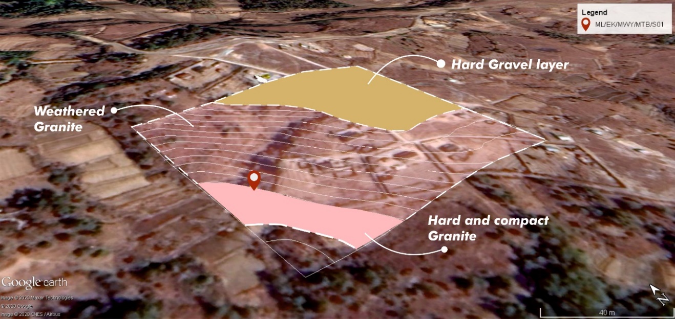
| Loose unconsolidated | ☐ |
| Weathered rock | 🗹 |
| Fractured-vertical | ☐ |
| Fractured-inclined | ☐ |
| Hard and compact | 🗹 |
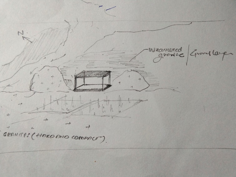
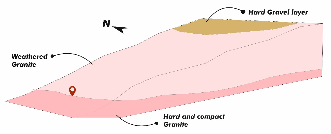
| Other Characteristics (mention if any) | The outcrops were not found around the source. However, little away from the source, couple of outcrops of weathered granites were found exposed |
|
|||
|---|---|---|---|
| Dip slope | ☐ | Vertical slope | ☐ |
| Escarpment slope | ☐ | Gentle slope | 🗹 |
Field sketch (conceptualising the springshed)
 |
|---|
Geological section or 3-D conceptual diagram of the Springshed
 |
|---|
Google Earth image of Hydrogeology of the springshed
 |
|---|
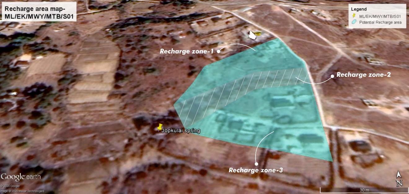
Google Earth image of the delineated potential recharge area/zone of the Spring (with specific interventions marked)
 |
|---|
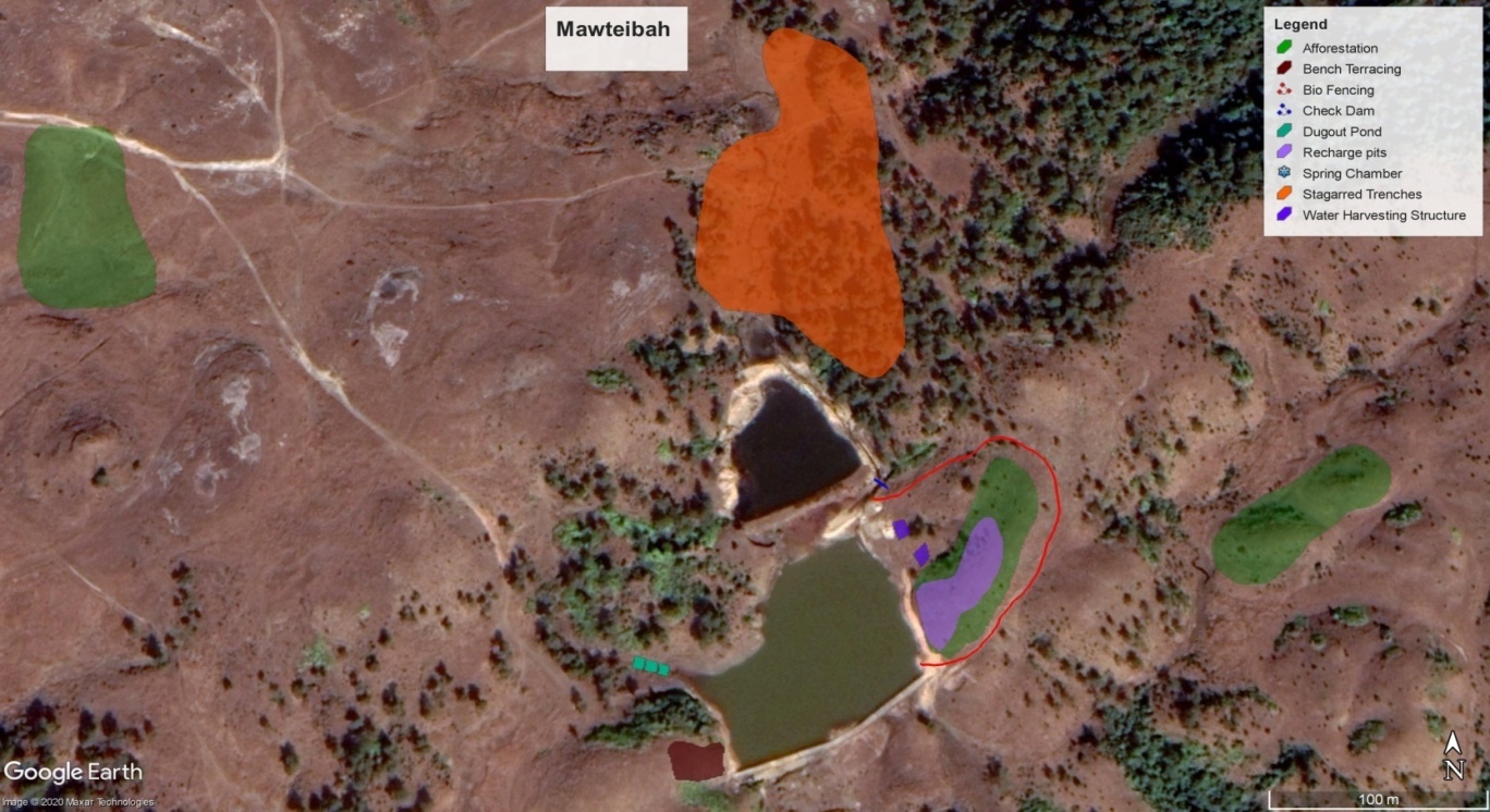
Details of the Spring Recharge interventions
| Recharge zones | Recharge intervention | Intervention Details |
|---|---|---|
| Recharge zone-1 | Roof-top rainwater recharge pit, Percolation Pit and plantation |
Number: 01 No. Requisite Roof Area per pit: 30 Sqm. Following is the construction sequence:
Number: 30 No. Following is the construction sequence:
Number: 100 No. Following is the construction sequence:
|
| Recharge zone-2 | Drainage line treatments | A) Loose boulder check dam Number: 3 (5M,6.25M and 7.5M Long) Following is the construction sequence
Key Points:
|
| Recharge zone-3 | Roof-top rainwater Recharge pit, Deep Recharge Pit with Fruit plant and Contour Trench in Agriculture field |
Requisite Roof Area per pit: 30 Sqm. Following is the construction sequence:
Number: 10 No. Following is the construction sequence:
Number: 25 M. Following is the construction sequence:
|
 Participants
List:
Participants
List:
 Expression
of Interest:
Expression
of Interest:
Land Use Land Cover Map
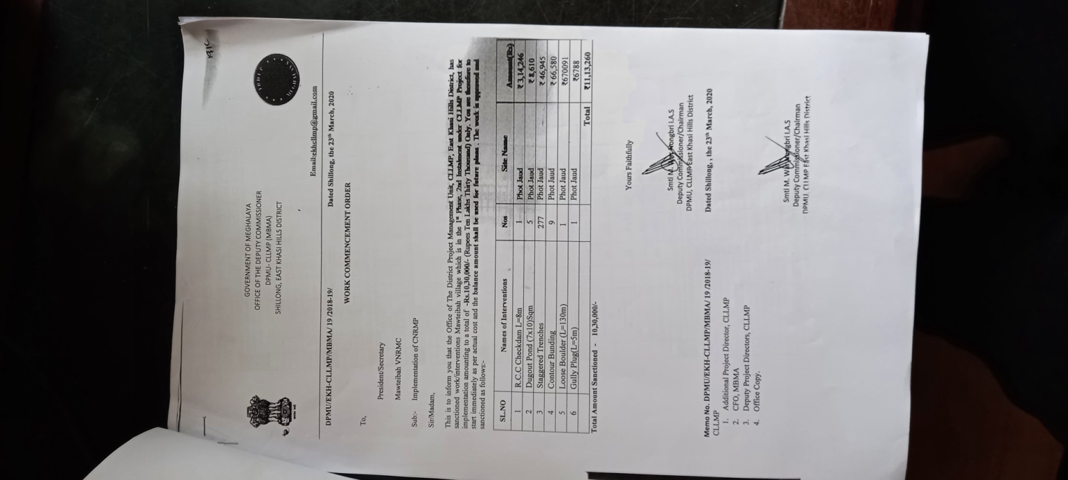
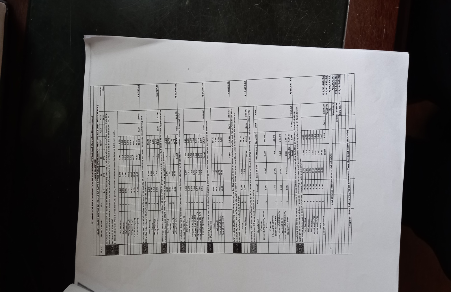
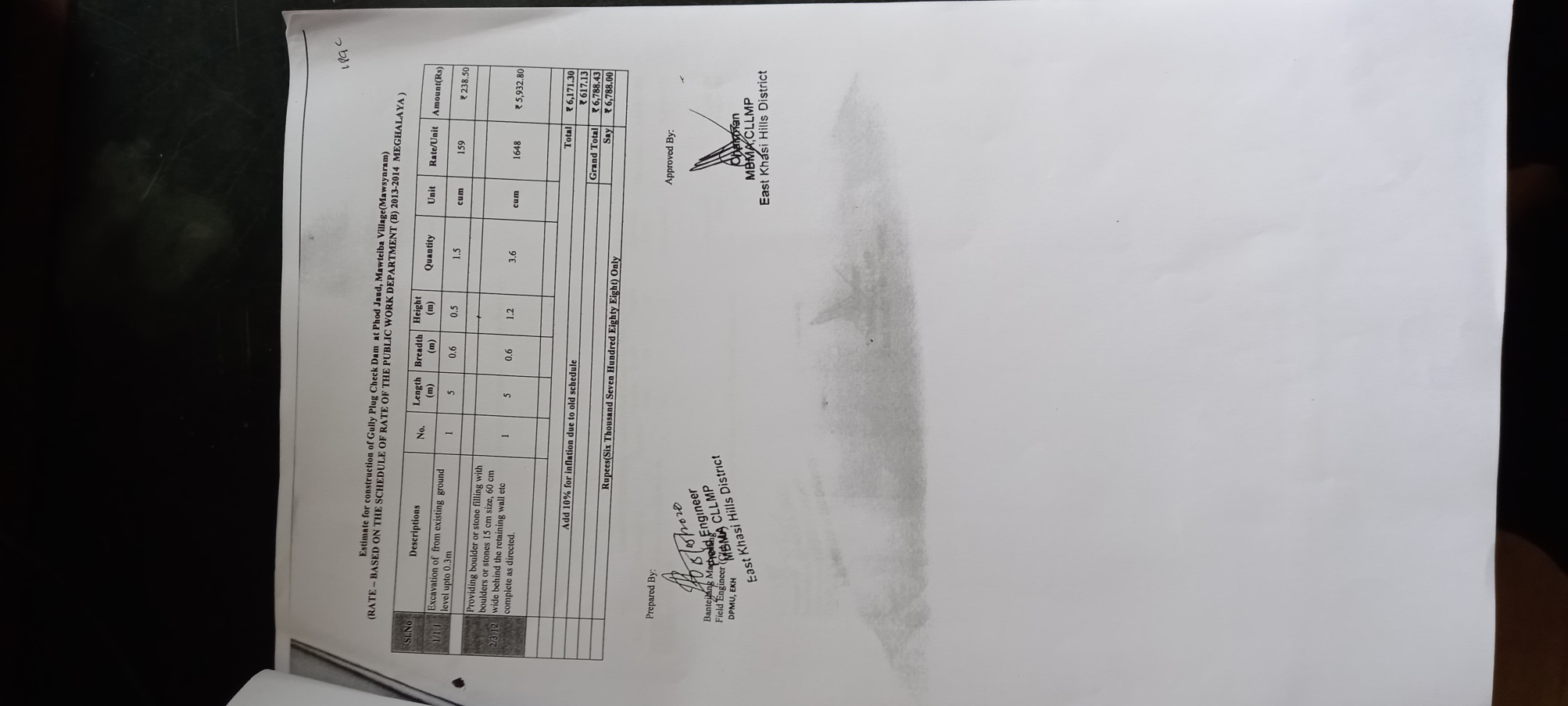
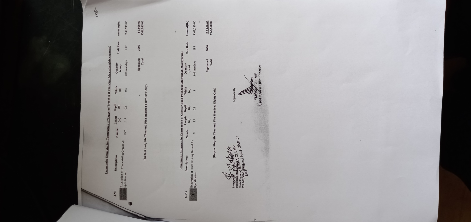
| Sl. No | TYPE OF INTERVENTION WORK | Number of Activities | SITE NAME | GPS COORDINATES | NO. OF WORK ORDER ISSUED | AMOUNT as per ESTIMATE from CLLMP (Rs) |
Convergence Amount (Rs) |
Treatment / Benefited Area (Hectares) |
Household Benefited |
START DATE | COMPLETION DATE | Remarks |
|---|---|---|---|---|---|---|---|---|---|---|---|---|
| 1 | Spring Chamber at 2 sites | 2 | Phodjopkulai & Dong Bangla | 25.38218 91.605810 25.382030 91.602280 |
15 | 18201 | 330000 | 0.05 | 24 | 16-09-2019 | 25-09-2019 | |
| 2 | CC Check Dam 1 Site | 1 | Phodumsaw | 25.39268 91.598700 |
51665 | 1000000 | 3.3 | 25 | ||||
| 3 | Water harvesting Structure at 1 Site | 1 | Phodjuad | 25.38595 91.604440 |
51665 | 1.15 | 120 | |||||
| 4 | RCC Check Dam at 1 Site | 1 | 25.37839 91.620388 |
314246 | 2 | 30 | ||||||
| 5 | Dug out Pond at 5 Sites | 5 | 25.37839 91.620389 |
8610 | 1 | 14 | ||||||
| 6 | Staggered Trenches (277 No's) at 1 Site | 1 | 25.37839 91.620390 |
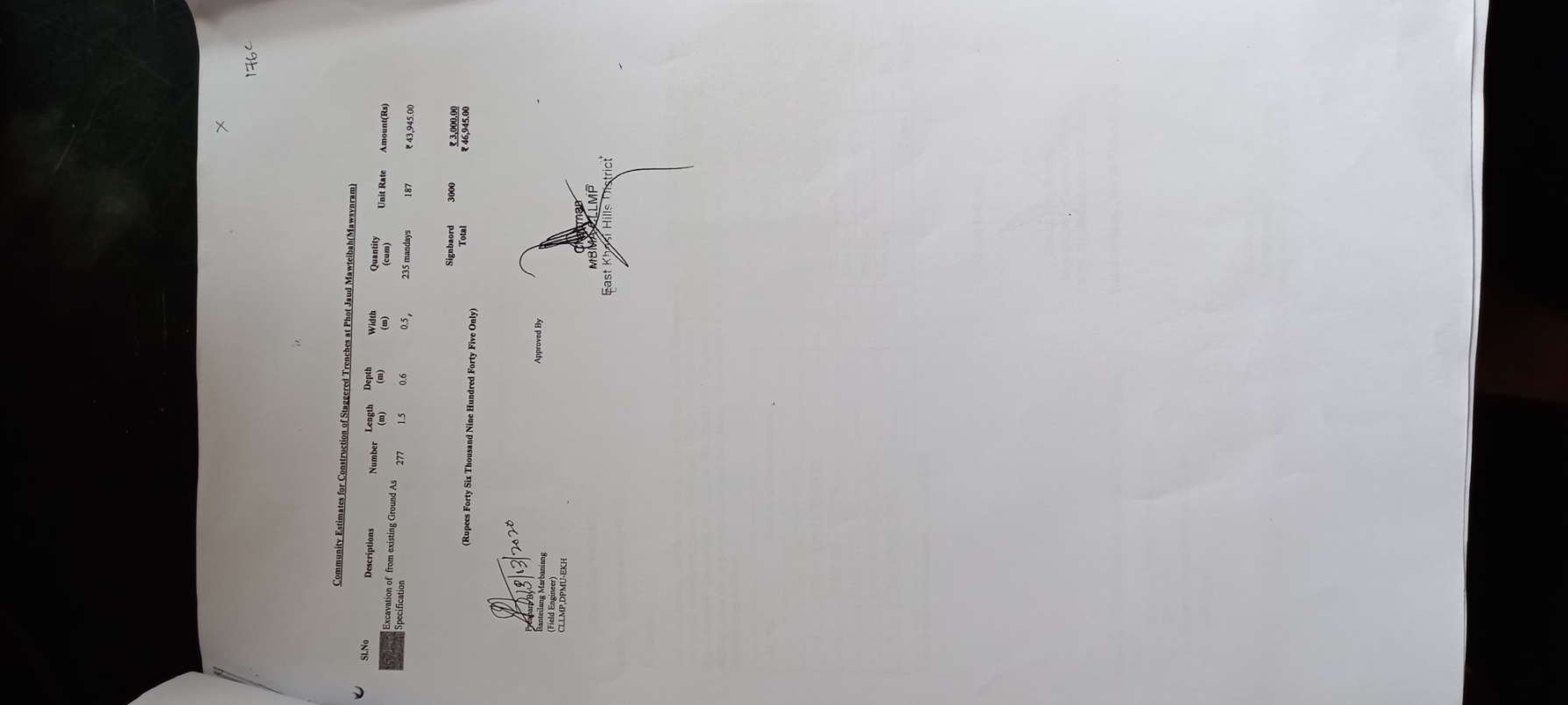
46945 | 0.65 | 26 | 15-08-2019 | 17-08-2019 | ||||
| 7 | Contour Bunding at 1 site (9 No's) | 1 | 25.37839 91.620391 |
66580 | 0.03 | 141 | ||||||
| 8 | Loose Boulder at 1 Site | 1 | 25.37839 91.620392 |
670091 | 7 | 130 | ||||||
| 9 | Gully Plug at 1 Site | 1 | 25.37839 91.620393 |
6788 | 0.5 | 130 | ||||||
| 10 | Afforestration (5000 Saplings) | 1 | 25.37839 91.620390 |
137854 | 4 | 130 |
Proposed list of Interventions
Budget:


Natural resource (particularly land) ownership and management in Meghalaya is complex – in the presence of customary norms and formal laws. The project intervention will be particularly mindful of such land ownership issues, particularly the nuances of community and private ownership issues. Screening of land sites identified for project interventions: All land for planned interventions would be undertaken on: Existing land available with the implementing agency; Government land accessed through department transfer; Land taken on lease under relevant legal provisions or through voluntary land donation by beneficiaries or taken through lease deed, private market; Purchase agreement or MOU with relevant institutions (like ADCs, Syiems/Nokmas) for community demand driven interventions. No private land acquisition will be undertaken under any project component.↩︎
Voluntary donation of land would be undertaken as per the following principles: That all donors would compulsorily become beneficiaries i.e. no individual or individuals would end up landless and therefore unable to benefit from the demand driven scheme. Such donors are adequately compensated for land given either in cash (at market rates) by purchasing body or given alternate land by contribution from other members. The process of taking such land would involve: Identification of demand from the community followed by assessment of suitability of land as per design; Drawing up of a MOU or agreement with the concerned parties; Such land taken on voluntary donation basis would be duly registered to avoid future complications↩︎
It is to be noted that poverty is not the only indicator that excludes or deprives a person or group from equal access to resources, services and information. Various other indicators such as ethnicity, clan, gender, religion, place of residence, age and others play a very important role in disabling or excluding people from a range of processes and opportunities. CLLMP aims to strengthen the capacities and knowledge of men, women and youths residing in rural Meghalaya. It also aims to ensure that all groups of people in the community are actively involved in the planning, management and monitoring of various initiatives↩︎
The team needs to be cognisant of the possibilities that influx of workers could lead to adverse social and environmental impacts on local communities, especially if the communities are rural, remote or small. Such adverse impacts may include increased demand for goods and services that can lead to price hikes and crowding out of local consumers, increased volume of traffic and higher risk of accidents, increased demands on the ecosystem and natural resources, social conflicts within and between communities, increased risk of spread of communicable diseases, and increased rates of illicit behaviour and crime↩︎
Wherever labour camps will be set up, it will be ensured that the contract labourers are properlydocumented for, the camps have suitable living conditions with safe drinking water, sanitary toilet facilities (earmarked separately for men and women)etc. Contractors’ agreements will have specific clause to ensure child labour and forced labour and banned at project sites, wages are provided as per legal guidelines, labour camp conditions meet adequate quality norms and every contractual employee have proper work-related documentation. The contract should also include clauses regarding reduction of waste general and safe disposal of waste at camp sites; ensure that workers’ camps and associated facilities are connected to septic tank or other wastewater systems which are appropriate and of sufficient capacity for the number of workers and local conditions; avoid contamination of freshwater resources; place workers’ camps away from environmentally sensitive areas to avoid impacts on the local wildlife; route new access routes for workers’ camps to avoid/minimize environmentally sensitive areas; avoid deforestation around camps; provide adequate training to workers on health and safety standards and ensure that children and minors are not employed directly or indirectly on the project↩︎