Village Profile on
Mawthungkper Village under Nongstoin C&RD
Block
District: West Khasi Hills District
10th March, 2021.
COMMUNITY LED LANDSCAPE MANAGEMENT
PROJECT
(CLLMP)


The Government of Meghalaya with Financial help from the World Bank is implementing the Meghalaya Community Led Landscape Management Project (CLMLP). The project will cover the entire state of Meghalaya and implementation of community led plans will be rolled out in phase manner throughout the state. The Meghalaya Basin Management Agency (MBMA) will facilitate community- led planning by providing support, technical inputs, and funding.
The project is intended to strengthen community led- natural resource management in selected landscape within the 11 districts of the state. The would be achieved through a variety of planning, capacity building, and on- the – ground interventions to promote the conservation, sustainable use of natural resources, social inclusion, and community mobilisation; building traditional knowledge and learning, mapping of natural resources management; strengthening the community institutions and creating linkage with financial institutions and community organizations.
The project interventions will include preparation of community led natural resource management plans. The CLLMP has the following three components:
Strengthening Knowledge and Capacity of Communities for Natural resource Management
Community Led Landscape Planning and Implementation
Project Management and Governance
The project objective is “to manage and conserve the natural resources, especially forests, soil and water sources, in a manner that supports the financial and physical well- being of communities in the State”
Scope
The CLLMP- Programme focuses on increasing the capacity of communities and traditional institutions (TI) by adopting a landscape approach to manage their natural resources such as soil, spring and other water source, forest and bio- diversity, etc.
The project will be planned and implemented in about 400 villages across the state.
CLLMP has a strong focus on institutions – building at the village- level, by ensuring systematic capacity-0 building in technical and social skill- sets.
The project will also extend such training to communities beyond the targeted villages and support effort made by them to access funding from various rural and natural resources initiatives and schemes
The programme will also invest in improving the process and outcome delivery, by developing and adhering to effective system and procedures, support by the appropriate technology.
Benefits:
Benefits for community (Skill and Capacity relating to technical and managerial areas like NRM and Conflict resolution
Benefits to traditional institutions (village councils, traditional leaders, community- based organizations, SHG etc) through knowledge sharing, promotion of innovative approach, access to technology, technical managerial and financial support.
It is estimated that the project will impact around 1 lakh partners (of which 50% are women) who depends on land, forest, agro forestry.
Through the project, 55000 Ha of targeted area will be ensured with availability of water, biological resources and soil productivity, which will in turn benefit around 400 villages and the outcomes delivery can be summarized as follows.
Implementation Agency:
The project will be executed by the MBMA in collaboration with other partners particularly, SIRD ( for training and capacity building), Department of Soil and water conservation, water resources Department, Forest Department , Specifically with respect to technical inputs, safeguards management and community NRM plan preparation.
Project period:
2018 – 2023 (5 Years)
TABLE OF CONTENT
1. INTRODUCTION & BRIEF HISTORY ………………………………………………….. 5-7
I.SOCIAL PROFILE……………………………………………………………………… 8
I. I- VILLAGE ACCESSIBILITY …………………………………………………… 8
I. II - LITERACY ………………………………………………………………………. 8
I. III- POPULATION …………………………………………………………………... 9
I. IV- CARD HOLDING HOUSEHOLD………………………………………………… 9
I. V - OCCUPATION ……………………………………………………………………. 10
I. VI- ENVIRONMENTAL CHALLENGES ……………………………………………. 10
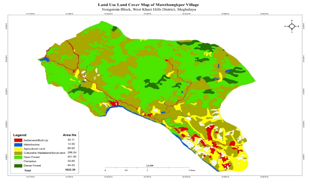
I. V- LAND USED LAND COVER PATTERN ………………………………………. 11
2. CLLMP ACTIVITIES…………………………………………………................................... 11
1. GROUND TRUTHING……………………………………………………………….. 11
` 2. SENSITIZATION ON CLLMP ………………………………………………………. 11
2. I- SIGNING OF EOI, VGA, AND GREEN CHARTER………………………… 11
2. II- FORMATION OF THE VNRMC……………………………………………….. 11
2. III- VILLAGE COMMUNITY FACILITATORS ………………………………….. 12-13
2. IV- PURCHASE COMMITTEE…………………………………………………… 14
3. OPENIGN OF BANK ACCOUNT……………………………………………………………… 15
4. PRA EXERCISE…………………………………………………………………………………. 16
4. I- VILLAGE BOUNDARY MAPPING AND RESOURCES MAPPING………. 17
4. II- BASIC SURVEY FOR CNRMP TEMPLATE ……………………………….. 18
4. III- FOCUSED GROUP DISCUSSION………………………………………… 18-19
4. IV -SEASONAL CALENDER…………………………………………………… 20-21
5. SUBMISSION OF CNRMP BY THE VNRMC………………………………………………… 22-23
5. I- THE FINAL CNRMP PLAN………………………………………………….. 24-26
6. GIS ACTIVITIES………………………………………………………………………………… 27
7 PROJECT IMPLIMENTATION…………………………………………………………………. 28-36
8. FUND STATUS………………………………………………………………………………….. 37-38
I: INTRODUCTION
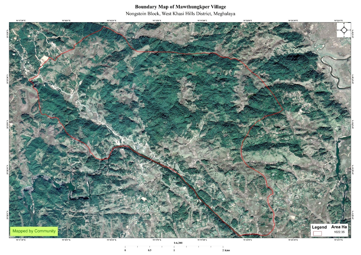
Mawthungkper village was situated in West khasi Hills under Nongstoin C&RD Block at 12KMs from Nongstoin Head Quarter. Mawthungkper villages have a Total 1022.35 Ha10.2235 sq km of geographical area with a total population of 772 villagers.
BRIEF HISTORY:
Preface- Firstly we thank the elders of the village especially Nongklung village (from which the village Mawthungkper cleaved) which help and preparing and writing this history even though the time is short but we have tried to collect all the data about the village arduously especially since the formal record cannot be found anymore.
Briefly about the village: According to the tales told by the elders, the village got the name Mawthungkper because the pillar (Maw) was laid (thung) in the garden (kper) of Bon Jyndiang, henceforth, since that time the village was called Mawthungkper. The location of the village is about 10km towards east from Nongstoin, West Khasi Hills District which is Under the Nongstoin Syiemship.
Foundation of the village: The Mawthungkper village was started when there was a Youth Service District Nongstoin came in the village in the year 1939 to open a school where only 2 houses were there at that time, they were 1) The house of Kong Riang Jyndiang 2) The house of Briah Kharsyiemlieh and the total number of villagers was 11. Since then, the village was under the care by the village Nongklung, Later the Mawthungkper village elected its own leader or headman to look after the welfare of the village and Mohan Kharbani was chosen to look after the Jaidoh locality. As the years passed by, the numbers also had increased and it was on the year 1969, along with Jaidoh the village was started. 13 years later which was in the year 1976 Mawthungkper village parted itself from Marang Jaidoh.
In the year 1977 when, Mohan Kharbani resigned from the position of being the headman of the village, the village elected Kirsingh Kharbani as the new headman. Not long Kirsingh also resigned from the post in the year 1980 and the village again had to choose new headman but this time it was Kome Kharbani was chosen as the new headman. As the years passed, there was the development of the village can be seen from every angle in different ways.
Number of schools in the village:
Mawthungkper Government Lower primary school.
Mawthungkper Upper primary school. Adhoc)
Kynroh Lower primary school (deficit)
Anganwadi Centre, Mawthungkper.
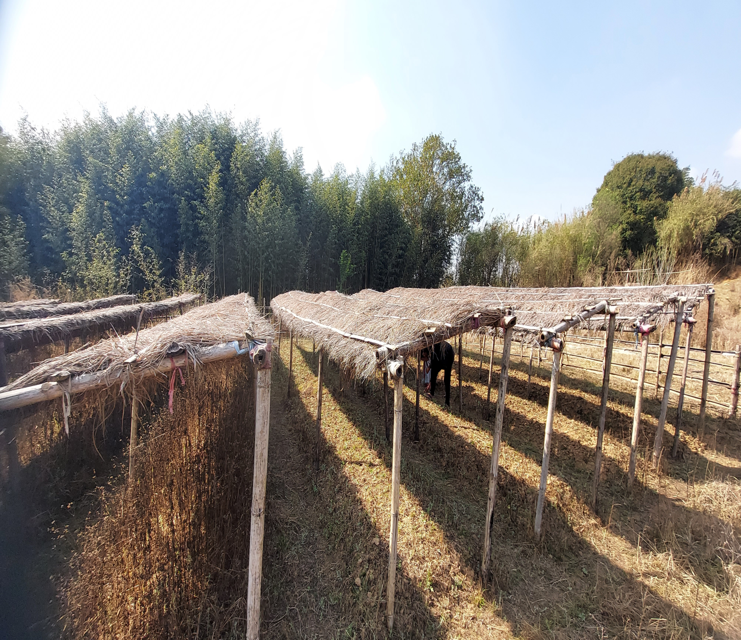
Occupation of the villagers: 70% out of 100% the villagers are farmers, some of the livelihood depends on animal rearing while other cultivate vegetables, fruits, flowers etc. 10% out of 100% are business and 20% out of 100% are government servants.
Locality / Block with in the village:
1. Locality Kynroh 2. Locality Umthiw 3. Locality Sdatahra
4. Locality Piengwait 5. Locality Pdengiingmane 6. Locality Dunmawlein
7. Locality Mawsadang 8. Locality Phuidramsong 9. Locality Domsken.
Forest with in the village:
1 Umtang 2. Mawlongniew 3. Tienmang
4. Ramsangriang 5. Shrahbah 6. Lawtngaw
7. Rwesynlwer 8. Umtangbah 9. Mawpohliew
Borders of the village:
East – Marang village and Nongrim Mawkhar village
West – Dumsaw and Nongjyllieh village
North – Domwahlang village
South – Kynshi River.
Name of Headman of the village:
Mohan Kharbani
Kirsingh Kharbani
Kome Kharbani
Kitboklin Nongdkhar
Population at present
No of Households – 117
No of villagers – 748
II. SOCIAL PROFILE
Mawthungkper Village has a total number of ` 122 households and with a total population of 772 people. Most of the people in the community are engaged in agriculture and some were engaged in business and government Job.
2.1Village Accessibility:
In order to reach Mawthungkper Village, one must venture through Shyieprangsang village walk straight till reached Nongjyllieh village walk forward and then reached Kynroh there was a sigh board on the left side of the road and pass through by until reached Mawthungkper Village.
2.2 Literacy:
As Per the 2011 census, the village literacy rate with a total 84 households residing in the village with a total population of 533 of which 269 are males while 264 are females. And the total of population literacy of 2011 census was 84.34%. Presently the total number of households was 122 with a total population of 772 of people. There are 3 schools in the village, 2 are Lower Primary School and one Upper Primary School.
Presently the village is managed and guided by its active Durbar as the highest authority in the village which is alternatively comprised of the Seng Kynthei, (Women Wing) and Seng Samla (Youth Wing) all collectively aiming for the overall good and growth of the village. Other committees such as (1) Village Employment Council (VEC), (2) Village Water and Sanitation Committee, and (3) Self Help Group (SHG) are constantly active and vigil as well, working in due co-operation between themselves for a brighter tomorrow of the village.
2.3 Population:
As per Census 2011, Mawthungkper Population is 533 and presently the total population of Mawthungkper Village has been increases to 772, out of this 372 are Males while the females count is 373. The Mawthungkper Village has 59 numbers at the age group of 0-4, 204 numbers at the age group of 5-14, 253 numbers at the age group of 15-30, 189 at the age group of 30-60 and 40 numbers above 60 of age.
| Age Group | Male | Female | Total |
|---|---|---|---|
| 0-4 | 39 | 42 | 81 |
| 5-14 | 122 | 124 | 246 |
| 15-30 | 105 | 114 | 219 |
| 30-60 | 19 | 22 | 41 |
| Above 60 | 14 | 21 | 35 |
2.4 Card Holding Households
BPL/APL Card Holding
| Particulars | No of HHs |
|---|---|
| BPL | 119 |
| APL | 3 |
Ration Card Holding Household:
| Particulars | No of HH |
|---|---|
| Total HH | 122 |
| Ration Card HH | 122 |
2.5 Fuel Type:
| Fuel Type | Total HH |
|---|---|
| Charcoal | 0 |
| Wood | 77 |
| LPG | 45 |
| Electric Heater | 0 |
| Kerosene | 0 |
2.6 Occupation:
The people of the village rely on agriculture and forest product for their livelihood and agriculture was the main work for the villagers followed by teacher and some were self-employed or daily wages.
2.7 Environtmental Challenges
Drinking Water: There is some lack of the drinking water in the village due to less discharge of water from some of the spring sources.
Road: The road is good enough till reach in Mawthungkper Village.
Water Bodies: Streams- 4
Forest- 4.13 ha
Cultivable Land- 4.6 ha
CLLMP ACTIVITIES
1. Ground Truthing Dated: 3/10/2019
The CLLMP officials met with Mr. Kitboklin Nongdkhar the headman of Mawthungkper Village and other village representatives on the 3rd of October 2019 for field assessment. Mr. Kitboklin Nongdkhar provided the Team with important information regarding the current scenario of the landscape and the natural resource management under his headman ship.
Case Findings:
There are a total of 115 households out of which 30hh (approx) fall under the BPL category.
Actively performing VEC.
Forest on hill slopes is prone to forest fires. Loss of Natural Vegetation.
Abundance of small streams
8. Paddy fields on upland areas are without proper irrigation
2. Sensitization Programme Dated: 22/10/2019
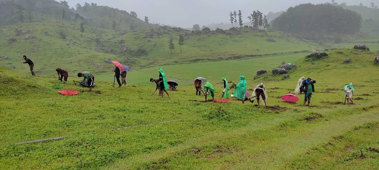
The District Project Manager and the Assistant Managers held a village Level sensitization Programme on the Community Led Landscape Management project on the 22nd October 2019. A total of 50 villagers actively participated in the program, voicing out their concerns and questions regarding the project making it a huge success.
Highlights of the Meeting;
Awareness about Community–Landscape Management project
Laying importance on the involvement of the community in making the CNRM plan and its success
3A brief awareness on cleanliness was conducted based on our findings during the ground Truthing phase
An interactive session was held to answer the doubts of the villagers regarding the project.
2.1 Signing of EOI, VGA and Green Dated 19th /9/2019
Mawthungkper Village signed the Expression of Interest (EOI), the Village Grant Agreement (VGA) and the Green Charter after there was a uniform agreement by the enitre community that the Community-Led landscape Management Project (CLLMP) be implemented at Mawthungkper Village.
2.2. Formation of the VNRMC Dated: 19/9/2019
Formation of the Village Natural Resource Management Committee was done in a public meeting in the presence of the entire village and the CLLMP staffs. The community chose the President, the Secretary, and the other executive members of the Committee.
Listed Below is the Member of VNRMC:
| Village Natural Resource Management Committee (9members committee constituted from Village Council, SHG group, Women’s group, youth, VEC) | ||||||||
|---|---|---|---|---|---|---|---|---|
| Sl No | Name in Full | Gender M/F | Age (in Yrs) | Education | Designation | Occupation | Community | Contact No and email address |
| 1 | Kornell K. Bani | Male | 70 | III | President | Farmer | Khasi | 9402100886 |
| 2 | Laindaris Jyndiang | Female | 34 | X | Secretary | Farmer | Khasi | 8837393185 |
| 3 | Neptilis Dkhar | Female | 40 | VIII | Finance Secretary | Farmer | Khasi | 9402132305 |
| 4 | Kwisdalin K. Bani | Female | 35 | X | Member | Farmer | Khasi | 9402129828 |
| 5 | Enjoyfulda K. Maw | Female | 30 | X | Member | Business | Khasi | 8837497283 |
| 6 | Stunly Shangpliang | Male | 52 | V | Member | Business | Khasi | 9402100613 |
| 7 | J.G Tympuin | Male | 50 | IX | Member | Business | Khasi | 8837093601 |
| 8 | Phrianstar Dkhar | Male | 58 | III | Member | Farmer | Khasi | N.A |
| 9 | Youkartis Dkhar | Male | 59 | I | Member | Farmer | Khasi | 985431526 |
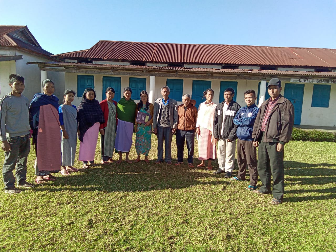
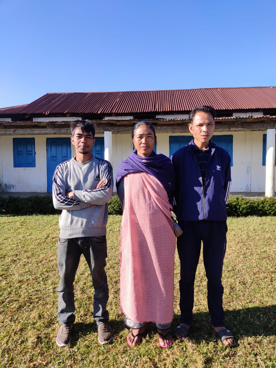
Fig: VCFs of Mawthungkper
2.3 Member of Village Community Facilitator
| List of Village Community Facilitator | ||||||
|---|---|---|---|---|---|---|
| Sl No | Name in Full | Gender M/F | Age (Yrs) |
Education | Area of specialization/ focus (forests, water, soil, accounts, environmental and social safeguards, knowledge management, GIS) | Contact No and email address |
| 1 | Bilistilda Dkhar | Male | 47 | IX | Social&KM | 9436534519 |
| 2 | Teiningstone | Male | 24 | XII | Environment &GIS | 1943670004 |
| 3 | Shoplindar K. Bani | Male | 35 | XII | M&E Documentation | 8132094789 |
2.4 Member of Procurement member
| List of Procurement members | |||||
|---|---|---|---|---|---|
| SL.NO | Name | Gender | Age | Education | Contact Number |
| 1 | Khrawkupar Kharbani | Male | 30 | Post Graduate | 8837043346 |
| 2 | Amerallis Jyndiang | Female | 29 | XII | 8837496700 |
| 3 | Kitboklil Nongdkhar | Male | 32 | XII | 8837499485 |
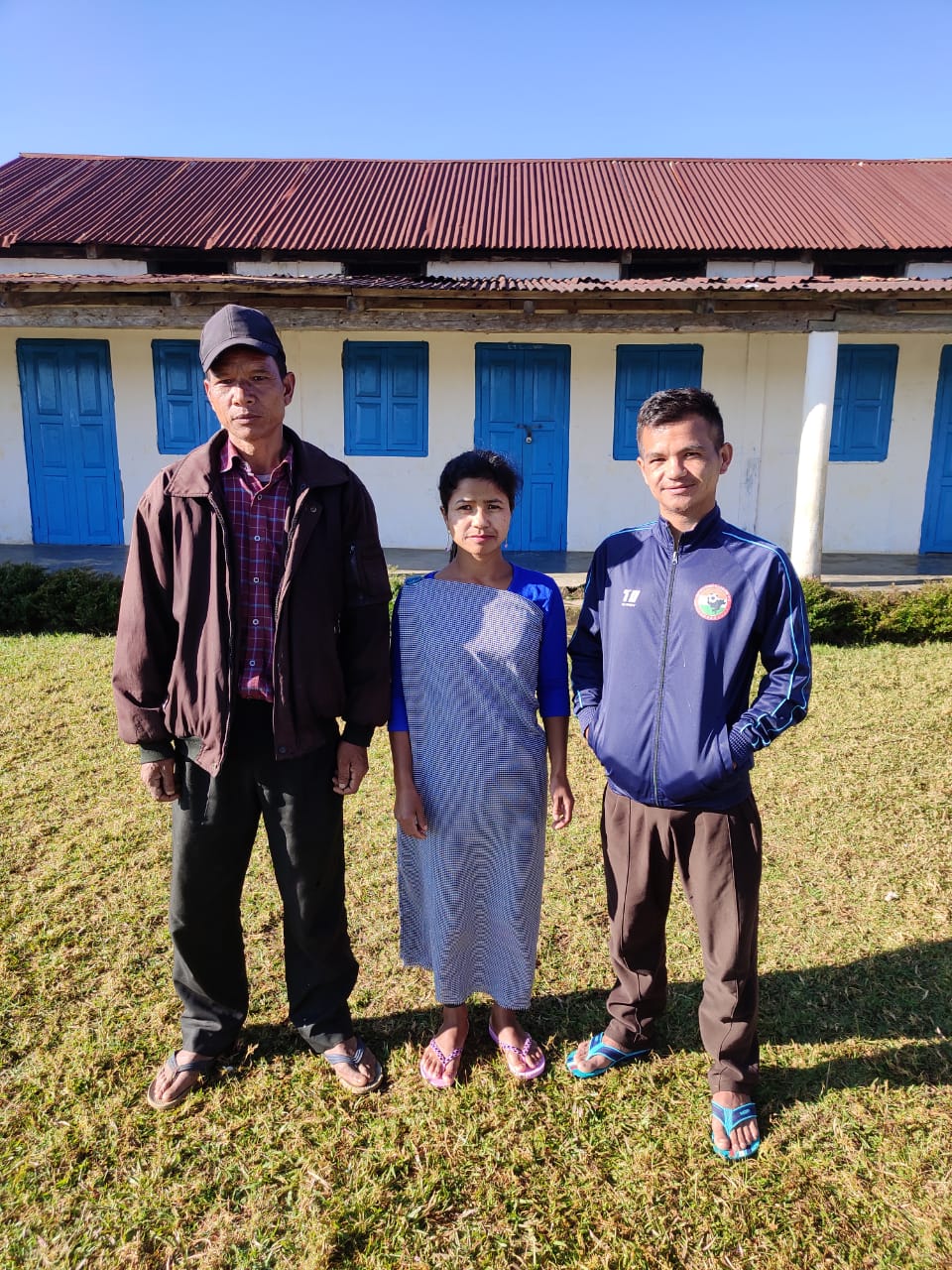
Fig: Members of Purchase committee
Opening of Bank Account Date: 10/10/2023
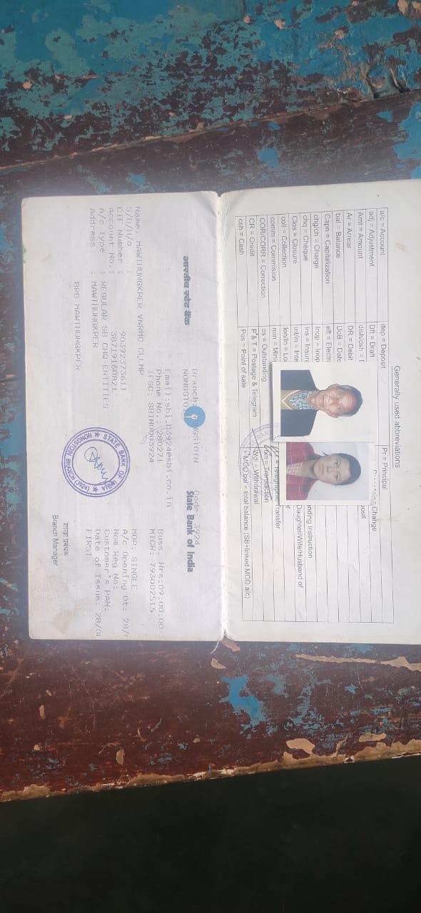 The opening of the bank
account was done after the signing of the EOI (Expression of
Interest), the VGA (Village Grant Agreement) and the signing of the
Green Charter at the respective villages meeting was held for all
the VNRMC members of Mawthungkper Village to brief and assist them
before opening the VRNMC bank account. The bank account was opened
on 10th of October 2019.
The opening of the bank
account was done after the signing of the EOI (Expression of
Interest), the VGA (Village Grant Agreement) and the signing of the
Green Charter at the respective villages meeting was held for all
the VNRMC members of Mawthungkper Village to brief and assist them
before opening the VRNMC bank account. The bank account was opened
on 10th of October 2019.
Fig: Bank Account Passbook
Participatory of Rural Appraisal Dated 11/11/2019
The PRA exercise aims to incorporate the knowledge and opinions of the community in the planning and management of development projects and programmers. The PRA exercise at Mawthungkper Village took place on 11th of November 2019 where there was a total of 30villagers, men and women included who took part in this exercise.
The initial stage of Participatory Rural Appraisal (PRA) exercise at Mawthungkper Village commenced with a meeting cum orientation program on CLLMP. While conducting the meeting, the community members were made aware of the various PRA exercises to be conducted for the development of Community Natural Resource Management Plan (CNRMP) of the village, the community members’ contribution in the exercise and the objectives to be achieved. The key informants (the VNRMC and the VCFs) helped facilitate maximum participation.
Commencement of PRA.
Introduction: Participatory Rural Appraisal (PRA) is the process of involving local people in the analysis and interpretation of their own situation of a given rural area. The local people i.e., the participants take a leadership role in collecting, analyzing, interpreting, and presenting information and in this process impart knowledge and development insight to the specialists and extension agents
For management of natural resources, participatory Rural Appraisal is conducted to establish rapport with the village community as well as to identify and define problems for prioritization in the village itself. It is a way of learning from and with community members to investigate their need assessment, analyze and evaluate constraints and opportunities and find out priorities in the area of agriculture, small scale rural enterprises and any other social and economic development programs addressed to village development based on the principle of listening and learning.
Objectives of PRA exercise at Pahamkroh Village:
The Participatory Rural Appraisal (PRA) exercise at Pahamkroh was conducted with following objectives:
To identify the natural, human, and economic resources of village.
To identify the village problems and prioritize them with the help of the community members.
To prepare the Community natural Resource Management Plan of the village.
4.1Village Boundary Mapping and drawing the Resource Map
The GIS personnel along with Village Community Facilitators mapped the village boundary of Mawthungkper Village.
The second step is to involve the local community in preparation of village resource map as perceived by the community members to solicit their participation. Infrastructure, services, and other village resources such as agricultural lands, wells, wastelands, cattle population etc. were mapped. Local people prepared the Resource Map by drawing it on a chart paper without much interference of outsiders.
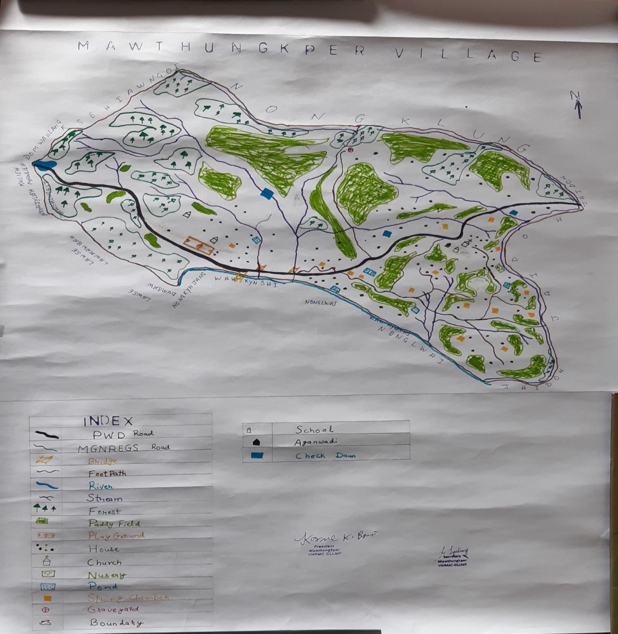
This activity achieved the following purposes:
Rapport building and won the confidence of the villagers.
Analyzed the spatial information, particularly studied problems and opportunities of villagers.
Got an impression about the village setting, physical layout, location of various houses and institutions.
Findings Based on the Resource Map of Mawthungkper Village:
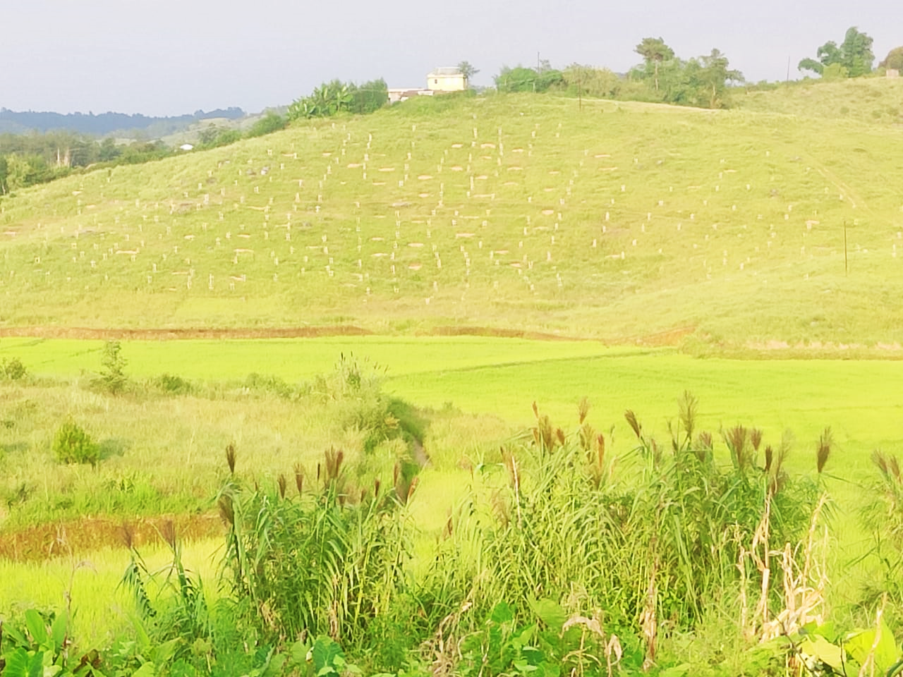
1. Main agriculture produce is Paddy, Banana, and ginger.
2. Presence of Barren land
3. Presence of Community Hall
4. Presence of Football playground.
5. Presence of Integrated Child Development Services (ICDS)
6. Four Spring with in the village.
7. Kynshi River was geographical area within the village.
8. School: There are 3 Schools. 2 Lower primary and 1 Upper Primary school in the village.
9. Habitation is not confined to one place but spread all over the village.
4.3
4.2 Baseline Data Survey to fill the Environment and Social Template
During the PRA exercise, the External Expert of Social Environment Management held group discussions with different groups to gather basic village information regarding number of households, demographic information, major crops, and enterprises taken in the village, trends of production and productivity of major crops in the village and demographic distribution of village population.
Information related to land use category such as forest, cultivable land, water bodies, etc and problems and challenges related to NRM were discussed.
4.3 Focused Group Discussion on Problem Analysis
A. Do people have sufficient access to supply of fodder, fuel wood, leaf litter?
Not sufficient
B. Has access to timber improved or reduced over the years? How is access for household use and commercial use managed?
Remain the same
C. Are the water bodies facing any threats?
Yes. Becoming scanty during dry season.
D. Do all people in the village have access to drinking water? What are the challenges?
Yes, shortage during winter season (waiting in line) and being far from the water source.
E. Are there degraded areas in the village (open/ degraded forests, mining affected, high soil erosion etc.)?
Yes.
F. What has caused this degradation? Are there practices causing threats to availability and access to natural resources?
Deforestation
G. What have been the changes in agricultural practices?
No changes. Traditional knowledge still in practice.
H. Are there any challenges in farming?
Yes. Water shortage and insect pest.
I. How would you consider the health situation in your village?
Good
J. How is the situation of cleanliness, sanitation, access to toilets and waste management?
Average (manage by the village dorbar)
K. Who are the most vulnerable in the village? What can be done to improve their lives?
-
L. What are the livelihood aspirations of the youth? Are there any avenues available?
Mostly manual laborer
M. Do any committees/ institutions/ rules exist to manage and monitor natural resources in the village?
Yes
N. What are some of the major issues of conflict in the village?
No
O. Have any of the above issues been discussed in village meetings?
-
P. How do people resolve disagreements and conflicts? Village durbar take care of the issues (if any)
-
4.4 Seasonal Calendar:
The CLLMP team also mapped the seasonal calendar of Mawthungkper village to help identify heavy workload periods, periods of relative ease, credit crunch, diseases, food security, wage availability etc. This will prove helpful in project planning and project timeline framing.
Participants:
Kitboklin Nongdkhar – Headman of Mawthungkper
Laindaris Jyndiang – Secretary of VNRMC
Kwisdalin K.Bani –Member of VNRMC
Neptilis Dkhar- Member of VNRMC
Bilistilda Dkhar- Village Community Facilitators
| SEASONAL CALENDER | |||||||||||||
|---|---|---|---|---|---|---|---|---|---|---|---|---|---|
| CRITERIA | JAN | FEB | MAR | APRIL | MAY | JUNE | JULY | AUG | SEP | OCT | NOV | DEC | |
| 1 | Water Scarcity | 1 | 1 | 1 | 3 | 2 | |||||||
| 2 | Prone to sickness | 3 | 3 | 1 | 1 | 1 | 3 | 3 | 3 | ||||
| 3 | Seeking job outside | 1 | 1 | ||||||||||
| 4 | Rain-fall | 3 | 3 | 3 | 2 | 1 | 1 | 2 | 3 | ||||
| 5 | Free- less work | 1 | 1 | 1 | 2 | 2 | 2 | 1 | 1 | 1 | 1 | 2 | 1 |
| 6 | Paddy cultivation | 3 | 3 | 3 | 1 | 1 | 1 | 2 | 2 | 2 | 3 | ||
| 7 | Paddy harvesting | 1 | 1 | ||||||||||
| 8 | Tree plantation | 3 | 3 | 2 | 2 | 1 | 1 | 1 | 2 | 3 | 3 | 3 | 3 |
| 9 | Vegetable (crop cultivation) | `3 | 2 | 2 | 1 | 1 | 1 | 1 | 1 | 1 | 3 | 3 | 3 |
| 10 | Vegetable (crop harvesting) | 3 | 3 | 3 | 3 | 2 | 1 | 1 | 1 | 1 | 1 | 1 | 2 |
| 11 | Festive season | 1 | 1 | 1 | 2 | 2 | 3 | 3 | 3 | 3 | 3 | 3 | 1 |
| 12 | Forest fire | 1 | 1 | 1 | 3 | 3 | |||||||
| 13 | Collection of fuel wood | 1 | 1 | 1 | 1 | 2 | 2 | 2 | 2 | ||||
| Maximum | 1 |
|---|---|
| Moderate | 2 |
| Less | 3 |
5. Submission of the CNRMP
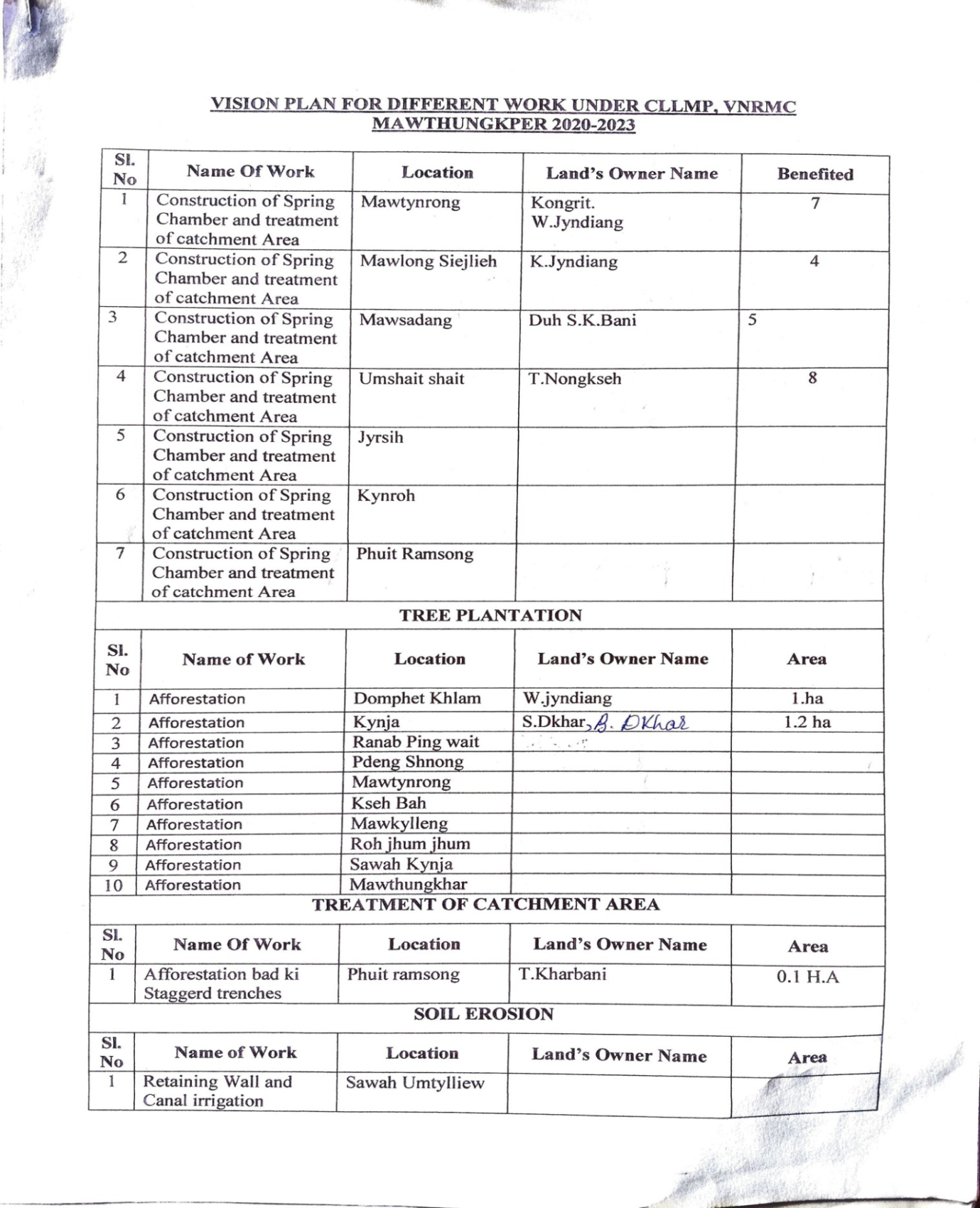
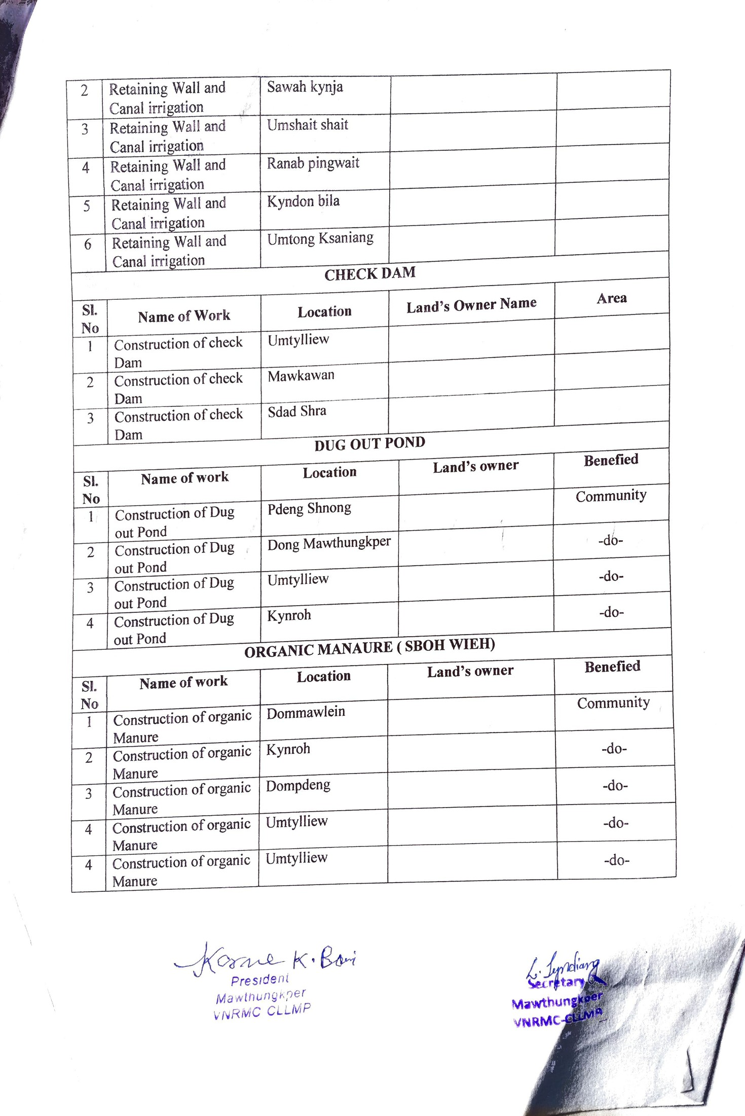
5.1 The Final Community Natural Resource Management Plan
|
Name of Proposed Interventions | Site |
|
Nos of HHs expected to Benefit | Priority (High/ Medium/ Low) | |||||
|---|---|---|---|---|---|---|---|---|---|---|
|
|
|
||||||||
| 1 |
|
Mawtynrong |
|
|
|
|
|
|||
| 2 |
|
Mawlong Syiemlieh |
|
|
|
|
|
|||
| 3 |
|
Mawsadang |
|
|
|
|
|
|||
| 4 |
|
Umshait Shait |
|
|
|
|
|
|||
| 5 |
|
Jyrsih | ||||||||
| 6 |
|
Kynroh | ||||||||
| 7 |
|
Phuit Ramsong | ||||||||
|
||||||||||
| Sl. No |
|
Location |
|
|
||||||
| 1 |
|
Domphet Khlam |
|
|
||||||
| 2 |
|
Kynja |
|
|
||||||
| 3 |
|
Ranab ping Wait | ||||||||
| 4 |
|
Pdeng Shnong | ||||||||
| 5 |
|
Mawtyrong | ||||||||
| 6 |
|
Kseh Bah | ||||||||
| 7 |
|
Mawkhylleng | ||||||||
| 8 |
|
Roh Jhum Jhum | ||||||||
| 9 |
|
Sawah Kynja | ||||||||
| 10 |
|
Mawthungkper | ||||||||
|
||||||||||
| Sl. No |
|
Location |
|
|
||||||
| 1 |
|
Phuit ramsong |
|
|
||||||
|
||||||||||
| Sl. No |
|
Location |
|
|
||||||
| 1 |
|
Sawah Umthylliew |
|
|
||||||
| 2 |
|
Sawah Kynja | ||||||||
| 3 |
|
Umshait shait | ||||||||
| 4 |
|
Ranab Pingwait | ||||||||
| 5 |
|
Kyndon bila | ||||||||
| 6 |
|
Umtong Ksaniang | ||||||||
|
||||||||||
| Sl. No |
|
Location |
|
|
||||||
| 1 |
|
Umthylliew | ||||||||
| 2 |
|
Mawkawan | ||||||||
| 3 |
|
Sdas Shra | ||||||||
|
||||||||||
| Sl. No |
|
Location |
|
|
||||||
| 1 |
|
Pdeng Shnong |
|
|||||||
| 2 |
|
Dong Mawthungkper |
|
|||||||
| 3 |
|
Umthylliew |
|
|||||||
| 4 |
|
Kynroh |
|
|||||||
|
||||||||||
| 1 |
|
|
||||||||
| 2 |
|
|
||||||||
| 3 |
|
|
||||||||
| 4 |
|
Umthylliew |
|
|||||||
GIS Activities:
| Sl. No. | Parameters (sl.no.1&2 to be filled by GIS Expert) | Village Information |
|---|---|---|
| 1 | GPS Coordinates: | |
| I | Latitude | 25.477641° |
| Ii | Longitude | 91.315275° |
| Iii | Elevation Reading (MSL) | 1550 m |
| 2 | Village Geographical Area (Ha) | Total:1022.35 Ha10.2235 sq.Km |
| I | Total Forest Area (including community, Clan, Pvt Forest) | 454.35Ha |
| Ii | Total Area of Water Bodies | 12.50 Ha |
| Iii | Total Area under Agri-Horticulture | 32.85Ha |
| Iv | Total Degraded land area (Ha) | 4.68Ha |
| 3 | Average Annual Rainfall | 1200 -3000 mm |
| 4 | Soil Type | Fine loamy soils |
`
Project Implementation:
| Type Of Intervention | Site Name | GPS Co-ordinates | Amount Sanctioned | Work Status | ||
|---|---|---|---|---|---|---|
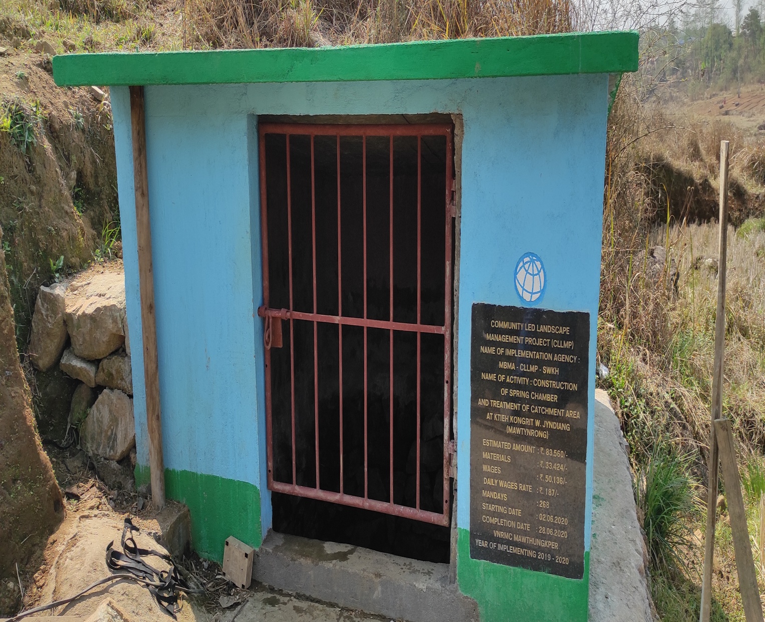
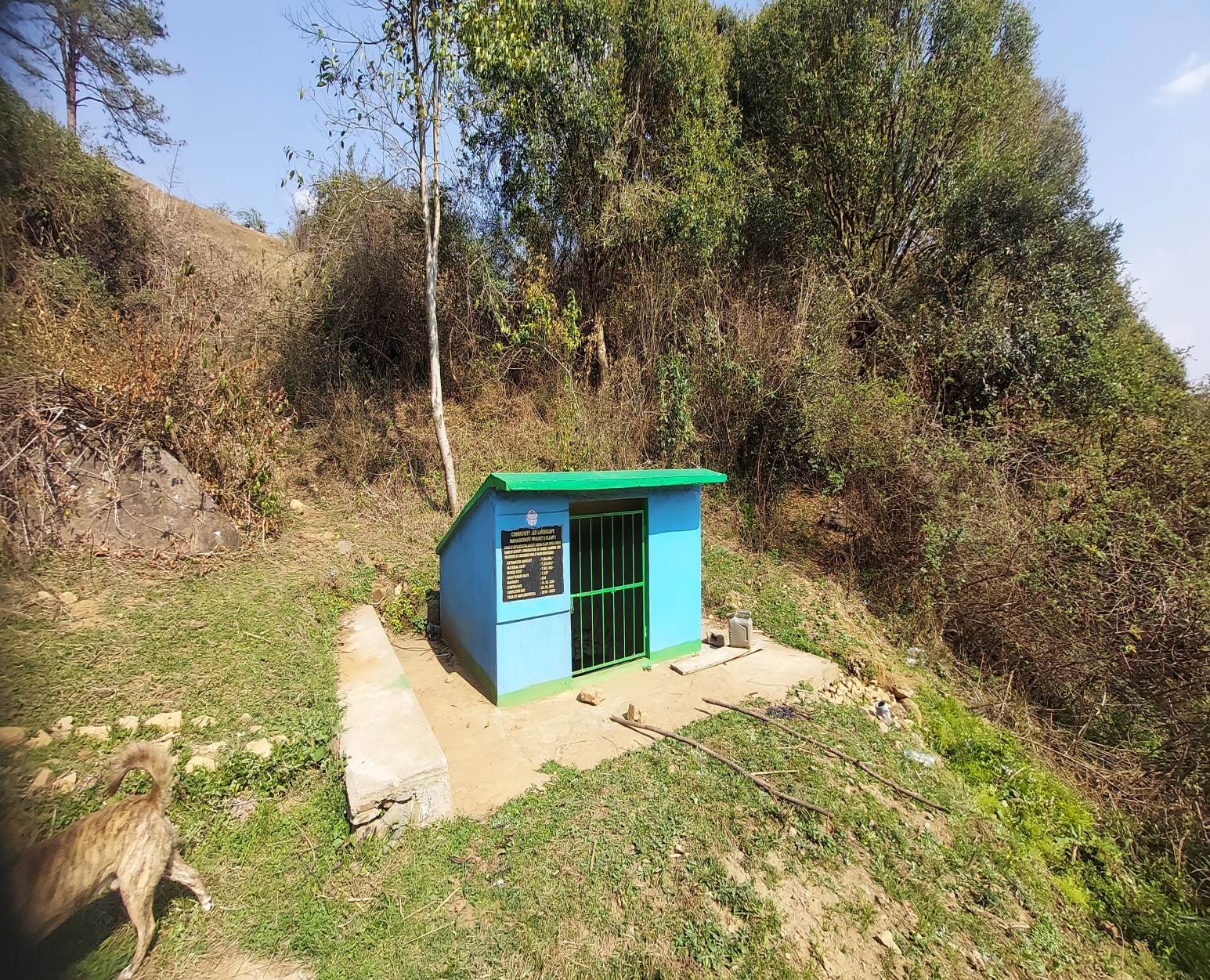
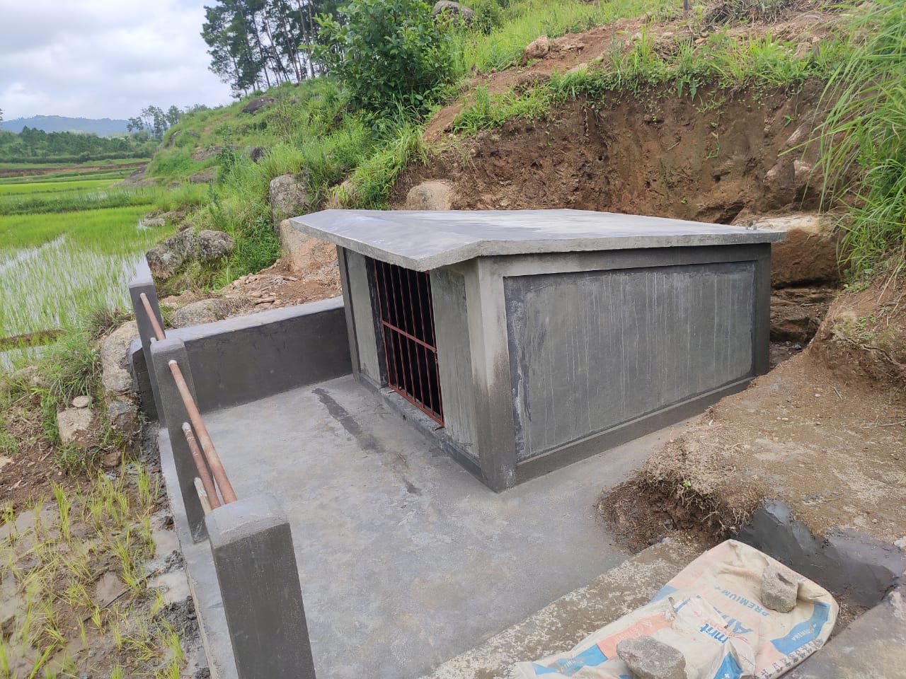
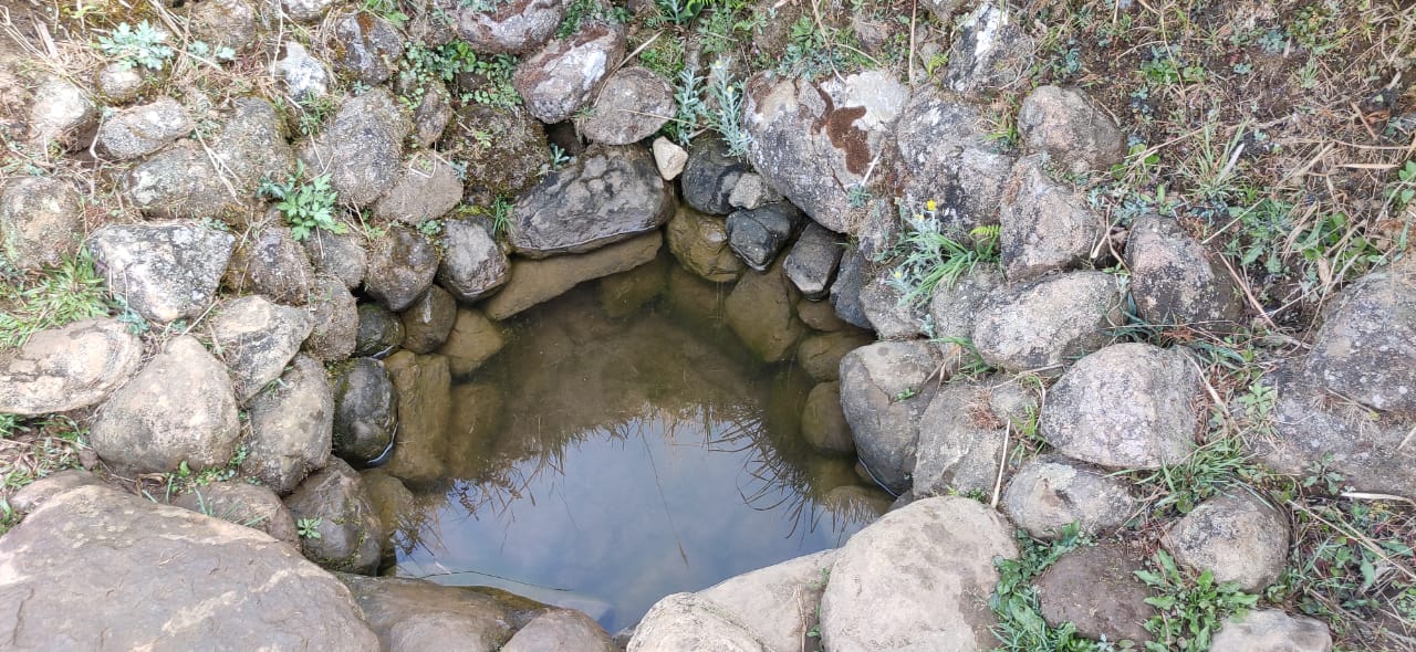
| Spring Chamber | Mawtynrong | 25.79262778 | 91.56059167 | 81,843 | Completed | |
| 2 | Type Of Intervention | Site Name | GPS Co-ordinates | Amount Sanctioned | Work Status | |
|---|---|---|---|---|---|---|
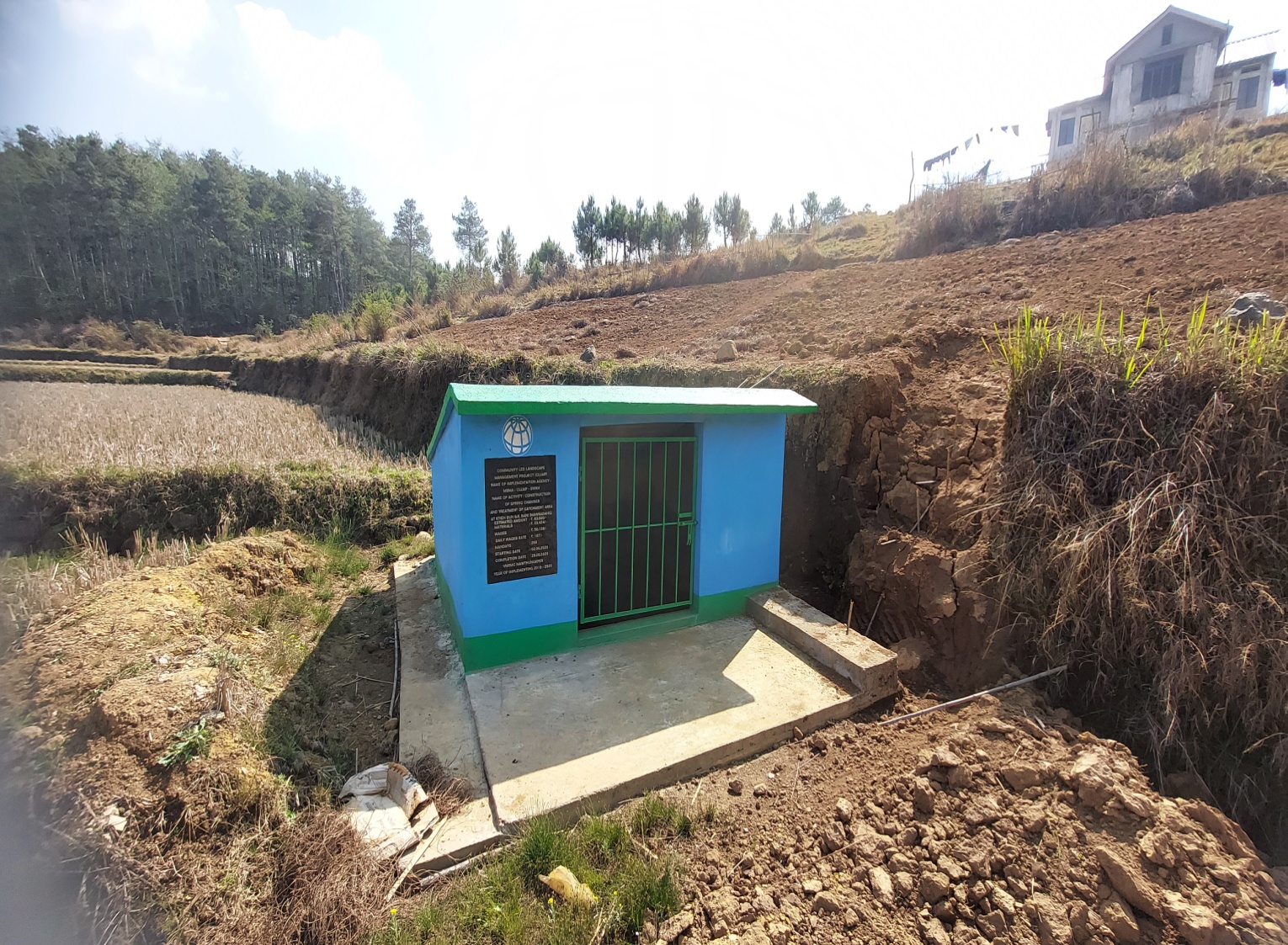
| Spring Chamber | Mawsadang | 25.78533056 | 91.5516 | 81,843 | Completed | |
| 3 | Type Of Intervention | Site Name | GPS Co-ordinates | Amount Sanctioned | Work Status | |
|---|---|---|---|---|---|---|
| Spring Chamber | Mawlong Siejlieh | 25.77853611 | 91.57988889 | ₹ 82,700 |
Completed | |
| 4 | Type Of Intervention | Site Name | GPS Co-ordinates | Amount Sanctioned | Work Status | |
|---|---|---|---|---|---|---|
| Community Nursery | Mawthungkper | 25.465962 | 91.332005 | 297280 | Completed | |
| 5 | Type Of Intervention | Site Name | GPS Co-ordinates | Amount Sanctioned | Work Status | |
|---|---|---|---|---|---|---|
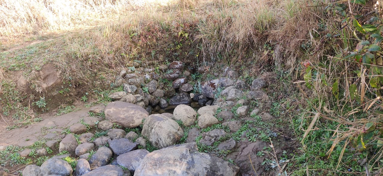
| Spring Chamber with TCA(Spring Chamber) | Umshaitshait | 25.46678194 | 91.33367889 | ₹ 77,580 |
Completed | |
| 6 | Type Of Intervention | Site Name | GPS Co-ordinates | Amount Sanctioned | Work Status | |
|---|---|---|---|---|---|---|
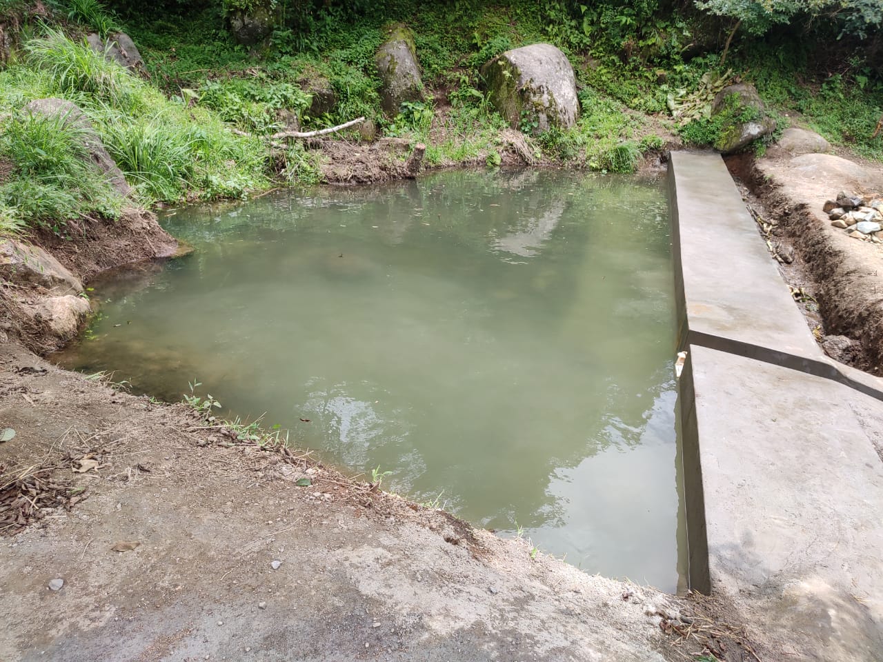
| Water Conservation Dam | Umthliew | 25.47243833 | 91.32860944 | 3,32,650 | Completed | |
| 7 | Type Of Intervention | Site Name | GPS Co-ordinates | Amount Sanctioned | Work Status | |
|---|---|---|---|---|---|---|
| Afforestation with Staggered trenches (Afforestation) | Domphetkhlam | 25.469191 | 91.334186 | 75,946 | Completed | |
| 8 | Type Of Intervention | Site Name | GPS Co-ordinates | Amount Sanctioned | Work Status | |
|---|---|---|---|---|---|---|
| Afforestation with Staggered trenches (Afforestation) | Kynja | 25.478089 | 91.321004 | ₹ 90,126 |
Completed | |
| 9 | Type of Intervention | Site Name | GPS Co-ordinates | Amount Sanctioned | Work Status | |
|---|---|---|---|---|---|---|
| Treatment of Catchment Area | Phuidramsong | 25.46419 | 91.33367 | 5,560 | ||
8. Fund Status:
| Fund Released to VNRMC (Project Implementation) | Total No. of Work Order Issued | Total amount Issued under CLLMP (Per Activity) | Total Amount Spent | Start Date | End Date |
|---|---|---|---|---|---|
| ₹21,55,000/- | Community Nursery | 2,14,311 | 16-Mar-20 | 23-Sep-21 | |
| Afforestation with Staggered trenches | 66,661 | 13-Jul-21 | 17-Aug-21 | ||
| Staggered trenches | 5,724 | 13-Jul-21 | 17-Aug-21 | ||
| Afforestation with Staggered trenches | 71,472 | 13-Jul-21 | 17-Aug-21 | ||
| Staggered trenches | 5,724 | 13-Jul-21 | 17-Aug-21 | ||
| Treatment of Catchment Area | 1,426 | 13-Jul-21 | 17-Aug-21 | ||
| Spring Chamber | 81,843 | 02-Jun-20 | 28-Jun-20 | ||
| Recharge pit | 1,717 | 02-Jun-20 | 28-Jun-20 | ||
| Spring Chamber | 81,843 | 02-Jun-20 | 28-Jun-20 | ||
| Recharge pit | 1,717 | 02-Jun-20 | 28-Jun-20 | ||
| Spring Chamber | 82,700 | 16-Mar-20 | 28-May-20 | ||
| Recharge pit | 860 | 16-Mar-20 | 28-May-20 | ||
| Construction of Spring Tap Chamber and Catchment Area | 72,685 | 04-May-21 | 10-Jun-21 | ||
| Treatment of Catchment Area | 6,864 | 04-May-21 | 10-Jun-21 | ||
| Spring Chamber | 70,866 | 06-Jun-22 | 30-Jul-22 | ||
| Water Conservation Dam | 3,32,609 | 11-May-21 | 30-Jun-21 | ||
| Construction of Water Conservation Pond | 2,99,700 | 11-Feb-22 | 30-Mar-22 | ||
| Irrigation canal | 6,36,300 | 04-Apr-22 | 28-Jul-22 | ||
| 2-Unit Vermicomposting | 72,300 | 29-Aug-22 | 30-Oct-22 | ||
| 2-Unit Vermicomposting | 72,300 | 29-Aug-22 | 30-Oct-22 | ||
| 2-Unit Vermicomposting | 72,300 | 29-Aug-22 | 30-Oct-22 | ||
| Water Tank | 2,83,100 | 05-Jan-23 | 31-Mar-23 | ||
| Total Amount Spent | ₹ 25,35,022 | ||||