
COMMUNITY LED LANDSCAPE MANAGEMENT PROJECT (CLLMP)
The Government of Meghalaya with financial help from the World Bank is implementing the Meghalaya Community Led Landscape Management Project (MCLLMP). The project covers the entire state of Meghalaya, and implementation of community-led plans are rolled out in a phased manner throughout the state. The Meghalaya Basin Management Agency (MBMA) will facilitate community-led planning by providing support, technical inputs and funding.
Theprojectisintendedtostrengthencommunity-lednaturalresourcesmanagementinselected landscapes within the 7 districts of the state. This would be achieved through a variety of planning, capacity building, and on-the-ground interventions to promote the conservation, sustainable use of natural resources, social inclusion and community mobilization; building traditional knowledge and learning, mapping of natural resources management; strengthening the community institutions and creating linkage with financial institutions and community organizations.
The project interventions will include preparation of community led natural resource management plans. The CLLMP has the following three components:
Strengthening Knowledge and Capacity of Communities for NaturalResources Management
Community-Led Landscape Planning and Implementation
Project Management and Governance
The project objective is “to manage and conserve the natural resources, especially forests, soil and water sources, in a manner that supports the financial and physical well-being of communities in the State”
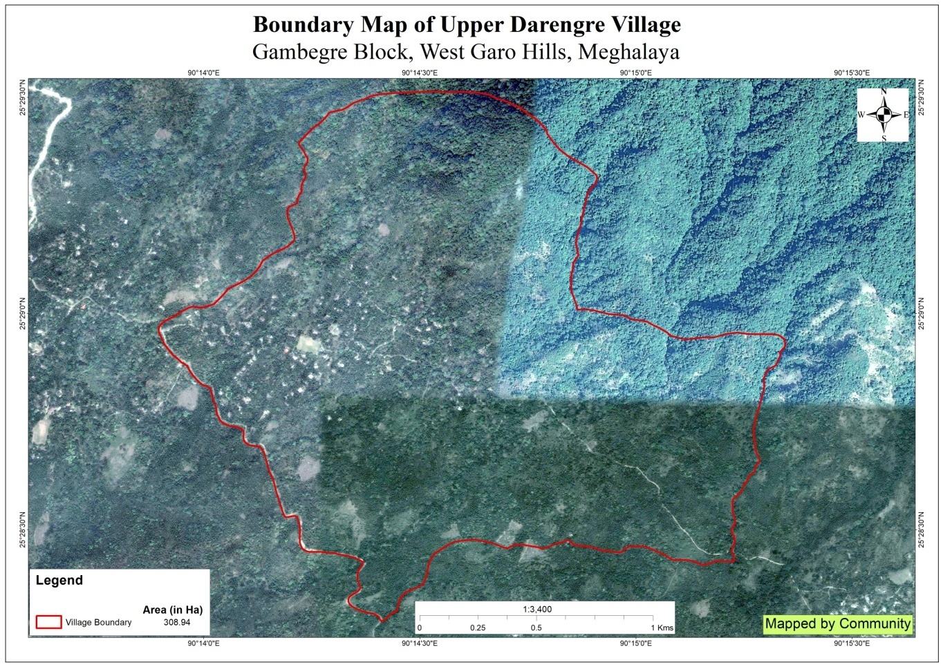
Upper Darenggre Village is situated under the Gambegre C&RD block of West Garo Hills district of Meghalaya. The village is about 20 km fromthe Gambegre Block office and 7 km from the district Headquarter, Tura. The village is under the traditional land owner of A’king Nokma. The total population and the demographic of both male and female of the village is about 590 with 118 number of households. As per the information from the community, there were around 5 to 10 number of tourists visited the Village especially Patanang Dare tourist spot.
The village can be reach through transportation such as Autorishaw and private vehicles, with a very limited access to its time to ply. However, these days, many of the community travel to and fro in their private vehicles as well as in their motor bikes.
The Village is about 20Km away from Gambegre Block and 7km away from district headquarter Tura. The public transport facilities to and from village is in Autorikshaw transport, and private vehicle. In respect to the Social Mobilization, it wasn’t that difficult to handle the community of this village as they are active and hardworking. Despite of very less facilities available, the community are very keen towards achieving the aims and objectives of CLLMP.
When it comes to use of fuel /LPG /biomass/gas most of the households are using Woodsand very less access to LPG. The community has few facilities such as education, safe drinking water supply, road and access to medical facilities. The village is under Head of village (Nokma). About 91 households still uses woods for cooking whereas about 97 households use LPG.
In regards to social profile, Upper Darengre village has total no of 118 households with the total population of 590.Out of which are302 male andare288 female.
The following is the demographic break up information acquired by the CLLMP team of WGH district.

 Upper
DarenggreVillage is still lot to catch up even though it is one of
the villages nearest to the Tura town area. Upper village are still
into farming which includes agriculture and multi cropping. Unlike
any other village’s Arecanut is always one of the most grown cash
crops followed by black pepper, banana, pineapple etc. People came
to observe and realize that the hill is gradually losing its soil
fertility and water retention properties. There are 103 HH farmers,
and 15 HH are Gov’t Service.
Upper
DarenggreVillage is still lot to catch up even though it is one of
the villages nearest to the Tura town area. Upper village are still
into farming which includes agriculture and multi cropping. Unlike
any other village’s Arecanut is always one of the most grown cash
crops followed by black pepper, banana, pineapple etc. People came
to observe and realize that the hill is gradually losing its soil
fertility and water retention properties. There are 103 HH farmers,
and 15 HH are Gov’t Service.
On the 8th June 2019, Assistant District Project Manager (ADPM) and Assistant Manager, Social Management of District Project Management Unit (DPMU), West Garo Hills visited Upper Darenggre village for Sensitization cum Ground Truthing.
Resensitization was again conducted on the 16th June 2020.
The village has 118 HH with 590 population .
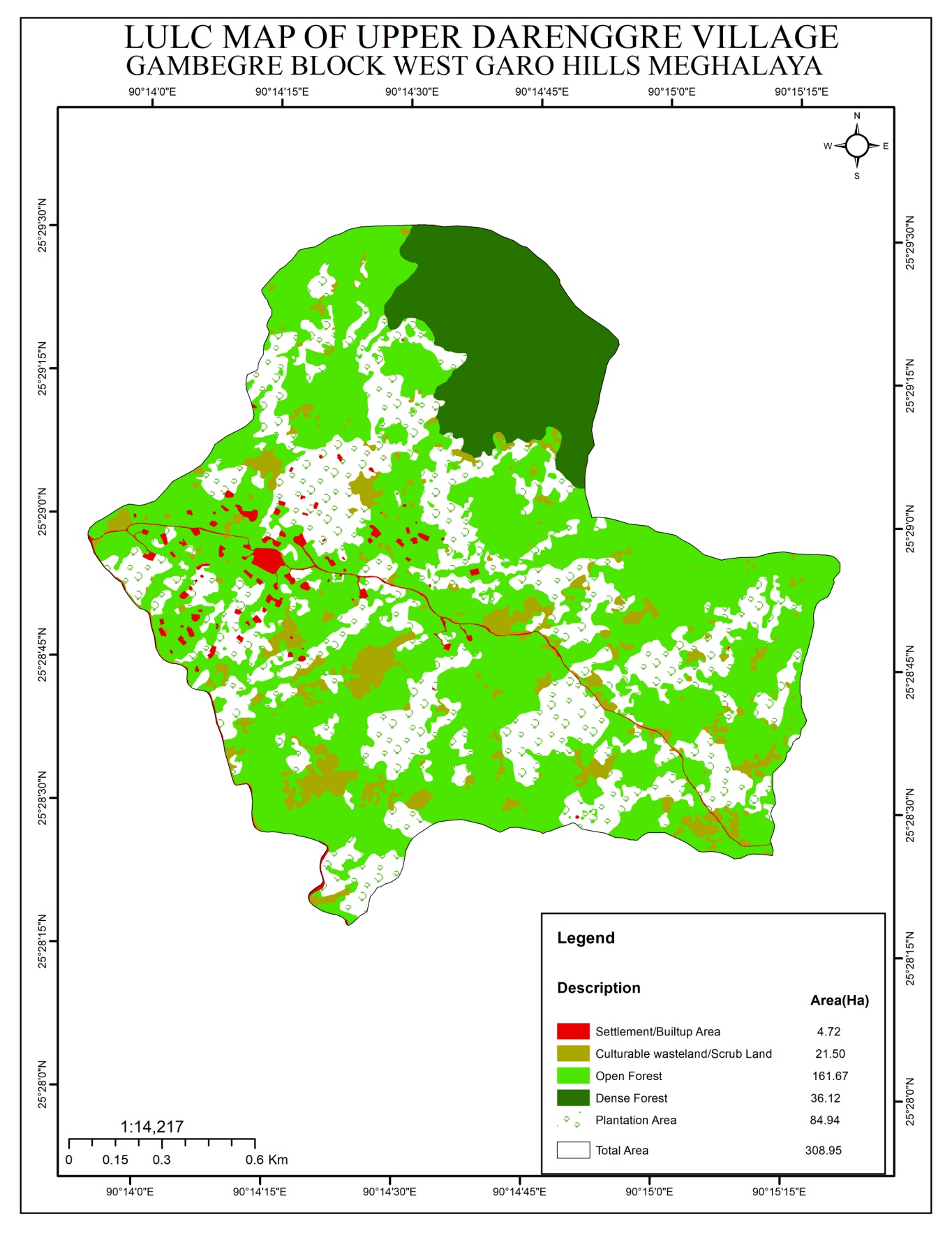
The village has Community forest
No degarded land . However low soil fertility
No proper drinking water facilities . The village water sources is streams. It has 5 streams.
No irrigation facilities for farming
The community own water catchment area has about of 0.03 ha
Thevillage has few medicinal herbs and endangered species in forest .
The village has many local tree species such as :-
Bolchim, siso, bolchu, kilwe, gimbal, smok, bolbaring, arime, chram, banyan, tiwek, dongkreng, pangkam, bolgisim, chambu
do.grikme (stomach ache, fever), chirota (malaria), samdisim (stomach ache), babribol (allergy), neem (allergy)
Narang, bamsim, tematchi
Samsimareng, Kasi, Touch me not plant, lantana.
Do.mesal, do.grik, do.brekot, do.kru, do.po, do.reng, do.rerapa, do.chelok, renggok, do.wang, chidawa.
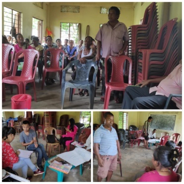
The District team of West Garo Hills conducted PRA and CNRM plan at Upper DarengreVillage on the 10th Sept 2019. Gambegre Block, WGH.
The exercises were conducted by the district team Social, Environment, M&E. TheTeam informed the community that PRA exercise is to understand and locate the natural resources of the village and plan the activities according to their need. The community had an exercise to plan and draw resource and social map on the same day.
In the exercise of CNRM plan preparation, the community were asked to prioritized the plan /activities and submit the plan to DPMU for 5 years. The exercises were done in the presence of villageheadmen, VNRMCs and Village facilitators. There were around 34 participants for the programme.
2.0 Signing of Documents:
As an acceptance and agreement to the project, every member of the village households had to sign green charter on 8th June, 2019 and submitted the Village agreement and Expression of Interest to DPMU.
 Formation
of the VNRMC
Formation
of the VNRMC
On 8th June, 2019 after the ground survey and sensitization programme, the village signed the EOI, VGA and Green charter as a sign of accepting the project. Whereas in regards, to the selection of Village Natural Resource Management Committee(VNRMC) members the Village Executive Committee (VEC) along with entire community carried out the process of selecting 15 chosen members such as 9 Executive members, 3 Purchase committee and 3 Village Community Facilitator .
Listed below are the members of the VNRMC:
| Sl No | Name in Full | Gender M/F | Age (in Yrs) | Education | Designation | Occupation | Community | Contact No and email address |
|---|---|---|---|---|---|---|---|---|
| 1 | Hinberth B Marak | M | 47 | Class X | Chairman | Farmer | Garo | 9077122641 |
| 2 | Palmera A Sangma | F | 33 | Class X | Secretary | Farmer | Garo | __ |
| 3 | Sulind A Sangma | M | 47 | Class X | Member | Farmer | Garo | 6009329053 |
| 4 | Injing A Sangma | M | 67 | Class X | Member | Farmer | Garo | -__ |
| 5 | Bitha A Sangma | F | 42 | Class X | Member | Farmer | Garo | - |
| 6 | Goodpilda B Marak | F | 44 | Class X | Member | Farmer | Garo | - |
| 7 | Bestha A Sangma | F | 37 | Class X | Member | Farmer | Garo | - |
| 8 | LaivishCh Marak | F | 37 | Class X | Member | Farmer | Garo | 8857230224 |
| 9 | Rapseng A Sangma | M | 54 | Class X | Member | Farmer | Garo | - |
Village Community Facilitators (VCF)
| Sl No | Name in Full | Gender M/F | Age (Yrs) |
Education | Area of specialisation/ focus (forests, water, soil, accounts, environmental and social safeguards, knowledge management, GIS) | Trained under CLLMP (Yes/ No?) if Yes, date training was received | Contact No and email address |
|---|---|---|---|---|---|---|---|
| 1 |
|
|
|
|
|
|
|
| 2 |
|
|
|
|
|
||
| 3 |
|
|
|
|
|
|
The District team of West Garo Hills conducted PRA and CNRM plan at Upper Darenggre Village on the 8th June 2019. Gambegre Block, WGH.
The exercises were conducted by the district team Social, Environment, M&E. TheTeam informed the community that PRA exercise is to understand and locate the natural resources of the village and plan the activities according to their need. The community had an exercise to plan and draw resource and social map on the same day.
In the exercise ofCNRM plan preparation, the community were asked to prioritized the plan /activities and submit the plan to DPMU for 5 years. The exercises were done in the presence of villageheadmen, VNRMCs and Village facilitators. There were around 43 participants for the programme.
Plan Estimate:
The DPMU of WGH made an inspection to the proposed intervention sites soon after the CNRM plan preparation gets over along with the district Field Engineer, Ms Nimrica Marak.
|
Implemented Activities | Name of Site | Work Status |
|---|---|---|---|
| 1. |
|
Church Compound |
|
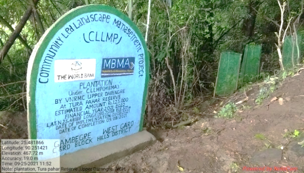
| 2. | Plantation | Tura Pahar Reserve | Completed |
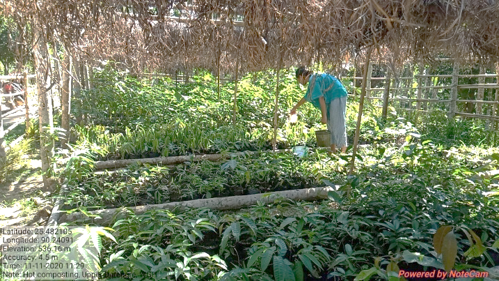
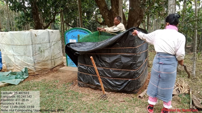
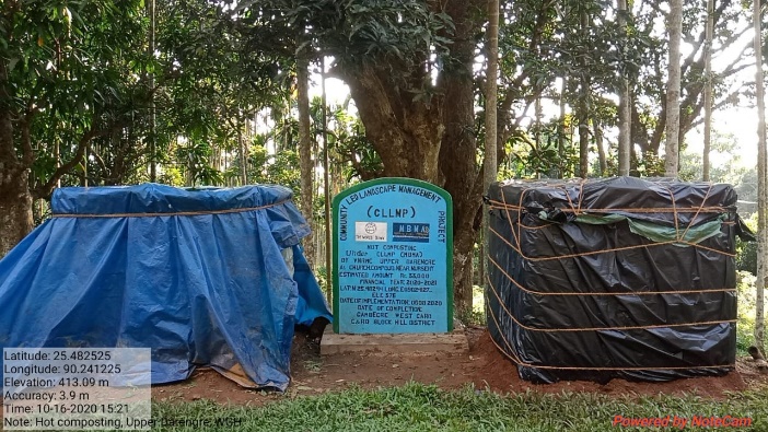
| 3. | 18 Days Hot Composting | Church compound near Nursery | Completed |
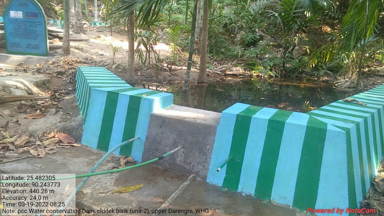
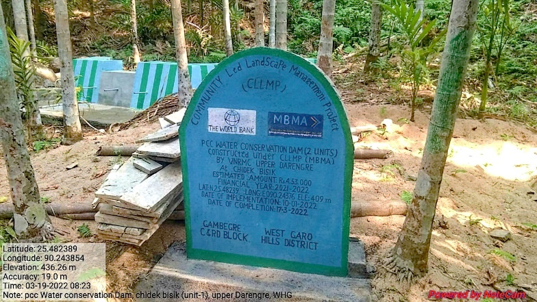
| 4. | PCC Water Conservation Dam (2 units) | Chidek Bisik | Completed |
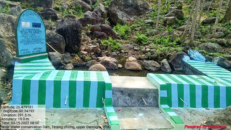
| 5. | Water Conservation Dam | Te.teng Chiring | Completed |
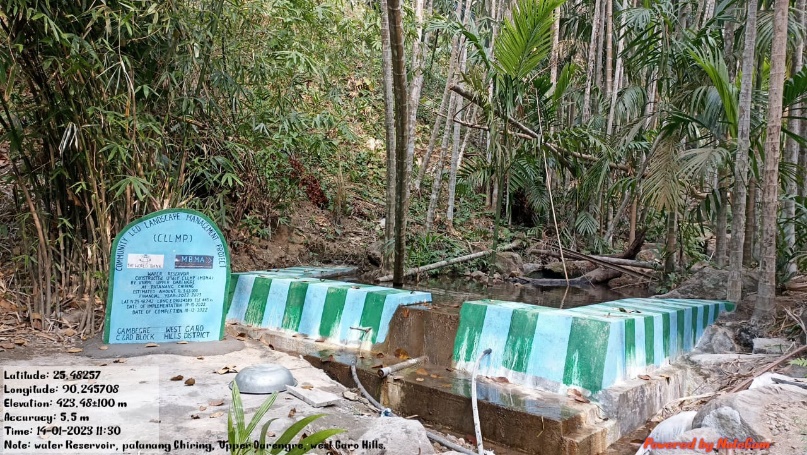
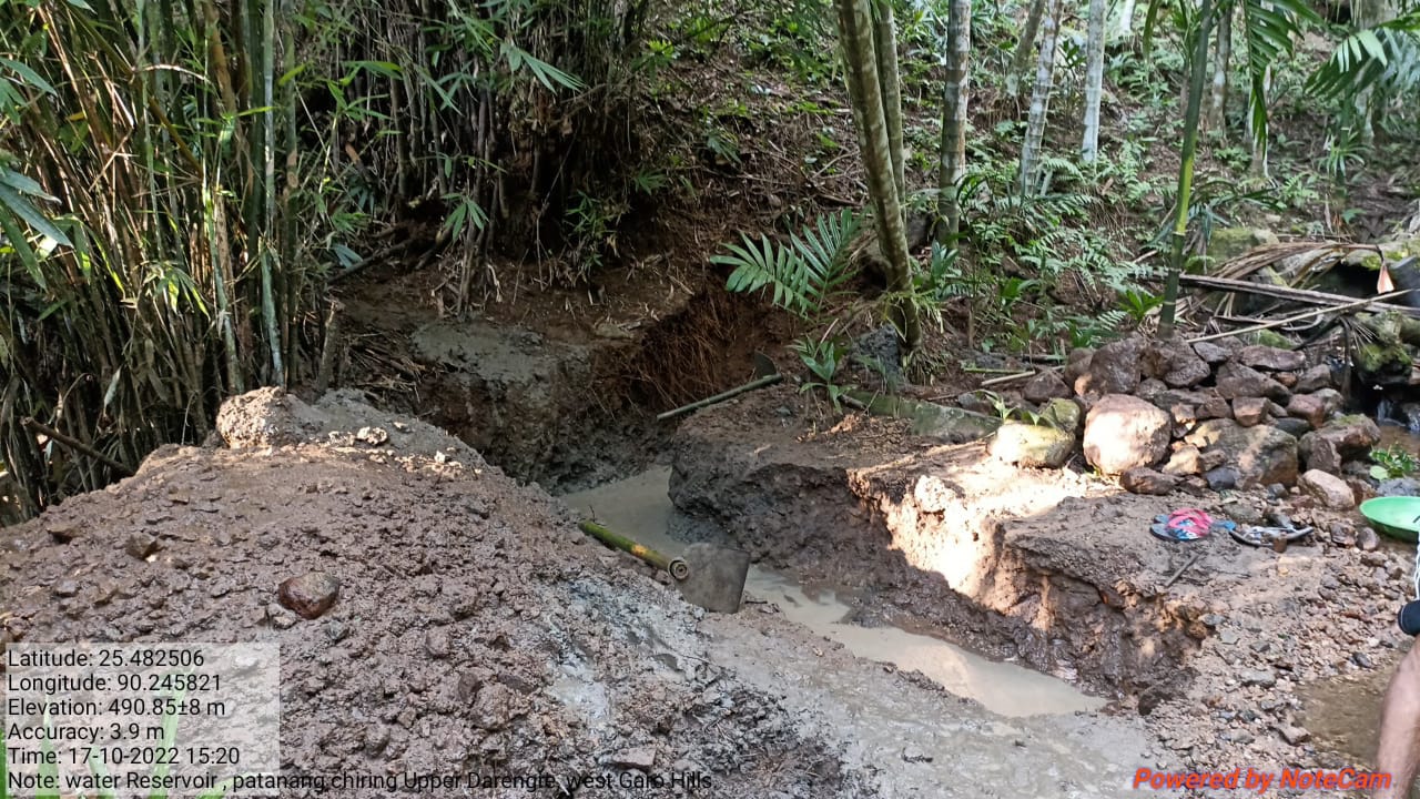
| 6. | Water reservoir | Patanang Chiring | Completed |
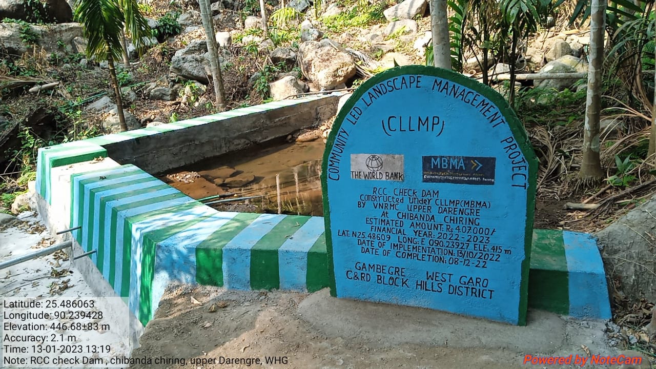
| 7. | RCC Check dam | Chibanda Chiring | Completed |
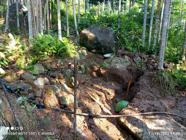
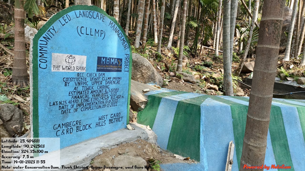
| 8. | RCC Check Dam | Tewek Chiring | Completed |
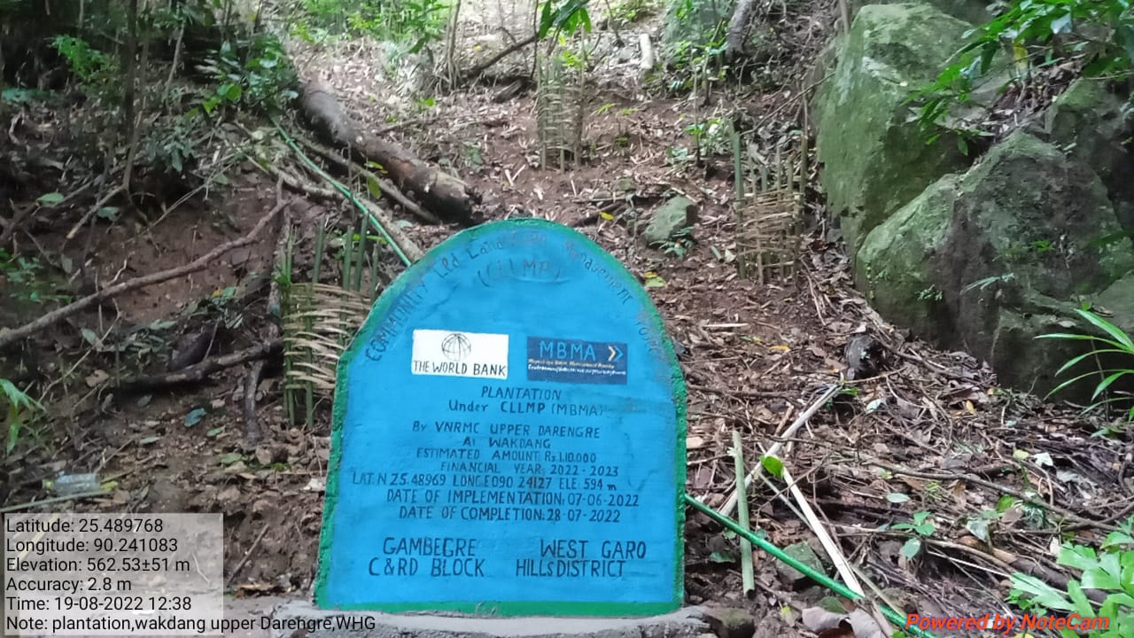
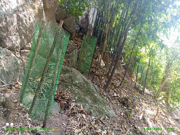
| 9. | Plantation | Wakdang | Completed |
4. Fund Status
| 1 | Type Of Intervention | Site Name | GPS Co-ordinates | Amount | Work Status |
|---|---|---|---|---|---|
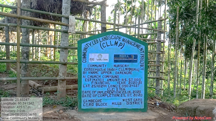
| Community Nursery | Church Compound | Elevation: 376m N 25.48244 E 090.24127 | Rs.57,000 | Completed |
| 2 | Type Of Intervention | Site Name | GPS Co-ordinates | Amount | Work Status |
|---|---|---|---|---|---|
| Plantation | Tura Pahar Reserve | Elevation 577m N 25.48188 E 090.25158 | Rs.1,25,000 | Completed |
| 3 | Type Of Intervention | Site Name | GPS Co-ordinates | Amount | Work Status |
|---|---|---|---|---|---|
| 18 Days Hot Composting | Church Compound near Nursery | Elevation 376m N 25.48244 E 090.24127 | Rs.33,000 | Completed |
| 4 | Type Of Intervention | Site Name | GPS Co-ordinates | Amount | Work Status |
|---|---|---|---|---|---|
| PCC Water Conservation Dam (2 units) | Chidek Bisik | Elevation 409m N 25.48239 E 090.24376 | Rs.4,53,000 | Completed |
| 5 | Type Of Intervention | Site Name | GPS Co-ordinates | Amount | Work Status |
|---|---|---|---|---|---|
| Water Conservation Dam | Teteng Chiring | Elevation 397m N 25.47927 E 090.24795 | Rs.3,00,000 | Completed |
| 6 | Type Of Intervention | Site Name | GPS Co-ordinates | Amount | Work Status |
|---|---|---|---|---|---|
| Water reservoir | Patanang Chiring | Elevation 445m N 25.48242 E 090.24580 | Rs.3,63,000 | Completed |
 Before After
| 7 | Type Of Intervention | Site Name | GPS Co-ordinates | Amount | Work Status |
|---|---|---|---|---|---|
| RCC Check dam | Chibanda Chiring | Elevation 415m N 25.48609 E 090.23927 | Rs.4,07,000 | Completed |
| 8 | Type Of Intervention | Site Name | GPS Co-ordinates | Amount | Work Status |
|---|---|---|---|---|---|
| RCC Check Dam | Tewek Chiring | Elevation 437m N 25.48470 E 090.24260 | Rs.3,07,000 | Completed |
Before After
| 9 | Type Of Intervention | Site Name | GPS Co-ordinates | Amount | Work Status |
|---|---|---|---|---|---|
| Plantation | Wakdang | Elevation 594m N 25.48969 E 090.24127 | Rs.1,10,000 | Completed |