VILLAGE PROFILE
NONGTYNNIAW VILLAGE
UNDER MAWKYRWAT C&RD BLOCK
DISTRICT: SOUTH WEST KHASI HILLS
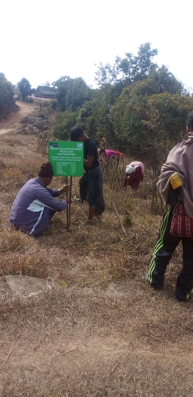
COMMUNITY LED LANDSCAPE MANAGEMENT PROJECT


The Government of Meghalaya with financial help from the World Bank is implementing the Meghalaya Community Led Landscape Management Project (MCLLMP). The project cover the entire state of Meghalaya and implementation of community led plans will be rolled out in phase manner throughout the state. The Meghalaya Basin Management Agency (MBMA) will facilitate community-led planning by providing support, technical inputs and funding.
The project is intended to strengthen community-led natural resources management in selected landscapes within the 12 districts of the state. This would be achieved through a variety of planning, capacity building, and on-the-ground interventions to promote the conservation, sustainable use of natural resources, social inclusion and community mobilisation; building traditional knowledge and learning, mapping of natural resources management; strengthening the community institutions and creating linkage with financial institutions and community organizations.
The project interventions include preparation of community led natural resource management plans. The CLLMP has the following three components:
Strengthening Knowledge and Capacity of Communities for Natural Resources Management
Community-Led Landscape Planning and Implementation
Project Management and Governance
The project objective is “to manage and conserve the natural resources, especially forests, soil and water sources, in a manner that supports the financial and physical well-being of communities in the State”
SCOPE:
The CLLM-Programme focuses on increasing the capacities of communities and traditional institutions (TI) by adopting a landscape approach to manage their natural resources such as soil, springs and other water sources, forests and bio-diversity, etc.
The project will be planned and implemented in about 400 villages across the state.
CLLMP has a strong focus on institution-building at the village-level, by ensuring systematic capacity-building on technical and social skill-sets.
The project will also extend such training to communities beyond the targeted villages and support efforts made by them to access funding from various rural and natural resources initiatives and schemes.
The programme will also invest in improving the process and outcome delivery, by developing and adhering to effective systems and procedures, supported by the appropriate technology.
BENEFITS:
Benefits for community (Skills and Capacity relating to technical and managerial areas like NRM and Conflict resolution
Benefits to traditional institutions (village councils, traditional leaders, community-based organizations, SHGs etc) through Knowledge sharing, promotion of innovative approach, access to technology, technical managerial and financial support.
It is estimated that the project will impact around 1 lakh partners (of which 50% are women) who depend on land, forest, agro forestry.
Through the project, 55000 Ha of targeted area will be ensured with availability of water, biological resources and soil productivity, which will in turn benefit around 400 villages and the outcomes delivery can be summarized as follows.
IMPLEMENTATION AGENCY:
The Project will be executed by the MBMA in collaboration with other partners particularly, SIRD (for training and capacity building), Department of Soil and Water Conservation, Water Resource Department, Forest Department, specifically with respect to technical inputs, safeguards management and Community NRM plan preparation.
PROJECT PERIOD:
2018-2023 (5 years)
Table of contents:
Introduction and History………………………………………………..4-5
Social Profile ………………………………………………………….6
Village Accessibility…………………………………….. 6
Literacy rate……………………………………………. 6
Population……………………………………………... 6
Occupation…………………………………………….. 7
Village organisation……………………………………. 8
Fuel Type………………………………………………8
Drinking Water………………………………………...8
Cultivatable Land………………………………………8
Forest Cover…………………………………………….8
Forest Species……………………………………………9
Water Bodies…………………………………………….9
Areas affected…………………………………………..9
III. CLLMP Activities
Ground-Truthing………………………………………………… 9
Sensitization on CLLMP…………………………………………10
Signing of EOI, VGA and Green Charter……………………….10
Formation of VNRMC…………………………………………...11
Village Community Facilitators…………………………………..12
Purchase Committee …………………………………………… ..13
IV. Opening of Bank Account …………………………….………………..13
V. PRA Exercise……………………………………………………………14
Basic Survey for CNRMP template……………………………….15
Focussed Group Discussions……………………………………16-17
Village Boundary Mapping and Resource Mapping………………17
VI. GIS Activities…………………………………………………………….18-19
VII. The Proposal list of intervention…………………………………………20-21
VIII. Project Implementation ………………………………………… ……..22-27
IX. Fund Status ………………………………………………………………..28
INTRODUCTION:
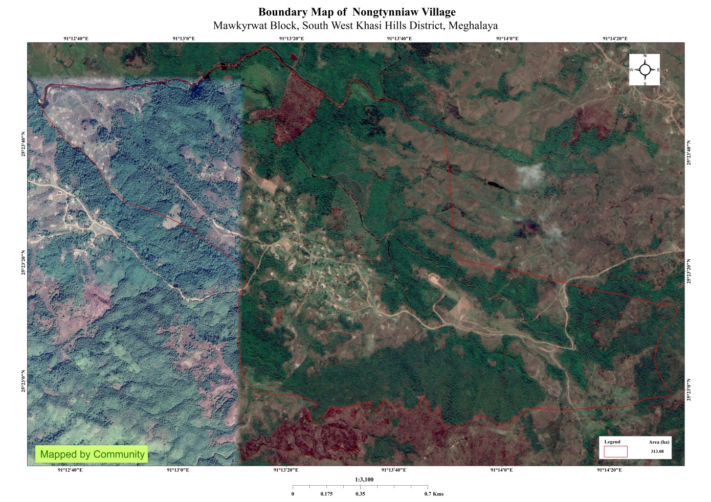
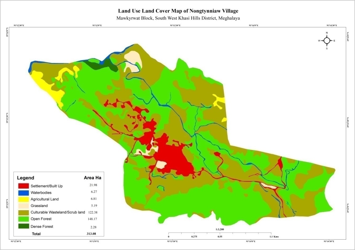
Nongtynniaw Village is situated in South West Khasi Hills District under the Mawkyrwat C&RD Block. The village is about 65 Km away from the District Headquarters i.e. Mawkyrwat and about 67 Km away from the Block Headquarters. It has a total geographical area of 313.08 Ha and falls under the Hima Nongstoin Syiemship. Nongtynniaw village has a total population of 1082 comprising of 268 males and 258 females. All the residents of Nongtynniaw village belonged to the Khasi Scheduled Tribe. The average rainfall of Nongtynniaw village is 1200mm and the type of soil is mainly loamy soil.
BRIEF HISTORY ABOUT THE VILLAGE:
The first people to ever settle in Nongtyññiaw were two people or two household that were siblings. They were:-
1) Larmih Marthong
2) Brimih Marthong
Before this they lived in one area called Lawbah-Nongtnger and overtime grew in numbers. At that time there was a bird called Jyllop that made its home by digging a hole near that place and the people made a wager that whoever was able to land arrows inside that hole, land will be awarded to them and the name of this land is Nongtnger. One person shot and managed to land an arrow inside the hole where the bird lived and he was given the land just like they previously agreed. In those days oral agreement and words were honoured and respected as people were still pure in spirit. After this, half of the people went and settled in the western part of Nongtynger and the other half went eastwards and settled in a place called Nongrim pleh.
But after settling there, a house caught on fire and because it was in the olden days, people believed in witchcraft and rituals (knia ka khriam) and the elders got rituals performed to find out the cause of the fire that burnt the house and was revealed that they were cursed (thiah bylle as the elders called it). It is said a one ‘ Thaw Niangram’ a ‘Lei Lum’ (Lei lum-a god of the hills) of Umjaraiñ a told them to move from that place and settle a little upwards to a new place and this new place was given the name Nongtynñiaw and the name was given by this Thaw Niangram.
When they settled in this new place they faced many difficulties and one of the main one is the unavailability of drinking water. They went to a shaman (nongthiah bylle) to help them locate a water source to meet their requirements. Thaw Niangram informed the shaman to tell the people to go to one particular area where there is a mark of some kind. They set out in search this place but it was full of rocks and dense forest which made it difficult to get through. They searched for the mark and sure enough there was a mark in the shape of a paw print made by a Tiger. They dug there and now they got water and called this place Umtongbah where the water is clean and clear. This water source is in the middle of Nongtynñiaw village which to this day is still there. As time passed the people of this village multiplied and in recent times this water source that was built by elders in the old days got renovated but in the renovation lots of rocks were shifted and removed. The water got muddy and unclear due to this that to this day it stayed that way and is now unfit for drinking and cooking. Now this source is used only for washing clothes. It never became clear and clean again like it was in the old days.
The name of the village Nongtynñiaw was given by Thaw Niangram and is located between two beautiful hills ‘Lum Langpoiñ’ and ‘Lum Langnar’
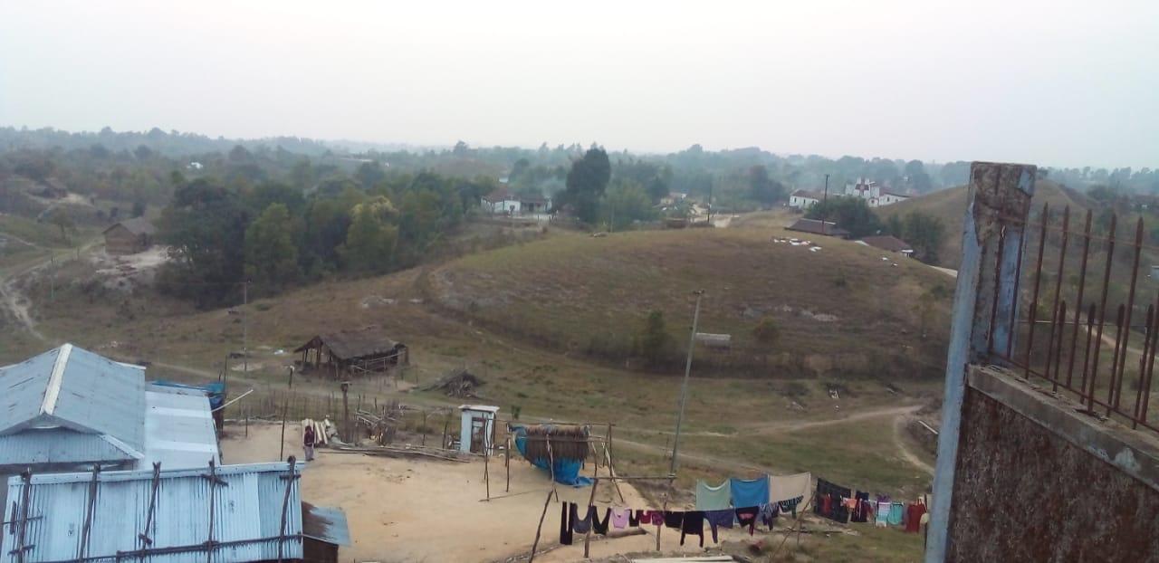
Fig: Nongtynniaw village.
VILLAGE SOCIAL PROFILE:
Nongtynniaw village has a total number of 125 households, having a total population of 811villagers. People in this village mainly depend on agriculture and its allied activities for their livelihood. There are teachers, businessmen and some others are engaged with government services.
Village Accessibility:
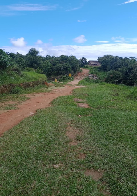
In order to reach Nongtynniaw village one must travel through road with local taxis from the Mawkyrwat- Wahkaji-Nongrynniang. road.
Literacy Rate:
According to Cencus 2011 informnation, literacy rate of Nongtynniaw village is 40.69% out of which 38.87% males and 42.44% females are literate.
Population:
The total population of Nongtynniaw village is 811 people and this has seen an increased over the years as of the recent survey. Out of this 811, 401 are male and the female count is 412.This village has 129 children belonging to the group 0-4years and 234 people at the age of 5-14 years. About 240 total numbers of people belong to the age group of 15-30 years, 163 people belong to the age group of 30-60 years and 47 people are above 60 years, thus this indicates that the majority of the population of Nongtynniaw village comprise of the young and healthy people.
| Age Group | Male | Female | Total |
|---|---|---|---|
| 0-4years | 68 | 61 | 129 |
| 5-14years | 113 | 121 | 234 |
| 15-30years | 127 | 113 | 240 |
| 30-60years | 72 | 91 | 163 |
| Above 60years | 21 | 26 | 47 |
| Total | 401 | 412 | 813 |
Occupations:
The people of Nongtynniaw village rely mainly on agriculture and forest produce for their livelihood. Out of 125 households within the village, 112 households are farmers, while 5 household are teachers and 8 households are in government service.
V. Organisation within the Village:
Presence of Village Natural Resource Management Committee in Nongtynniaw village (9member committee constituted from Village Council and VEC), SHG group, Women’s group, youth; 4 members are women.
| Sl No | Name in Full | Gender M/F | Age (in Yrs.) | Education | Designation | Occupation | Community | Contact No and email address | ||||||||
| 1 | Phimlandstar Thongni | Male | 50 | BA | President | Teacher | Khasi | 9402312140 | ||||||||
| 2 | PhimtimorialMarthong | Female | 27 | BA | Secretary | Farmer | Khasi | 9436549409 | ||||||||
| 3 | ClustarMarthong | Male | 42 | X | Finance Secretary | Farmer | Khasi | 9366790565 | ||||||||
| 4 | Marius Thongni | Male | 36 | VII | Member | Farmer | Khasi | 6009140714 | ||||||||
| 5 | Peter Wanniang | Male | 27 | X | Member | Farmer | Khasi | 7005493773 | ||||||||
| 6 | SharningDkhar | Male | 45 | I | Member | Farmer | Khasi | 9402545136 | ||||||||
| 7 | PhilismoraMarthong | Female | 29 | X | Member | Farmer | Khasi | 9485436138 | ||||||||
| 8 | ElnestinaMarthong | Female | 46 | VII | Member | Farmer | Khasi | NA | ||||||||
| 9 | TitifuldaMarthong | Female | 36 | VII | Member | Farmer | Khasi | 9436354142 | ||||||||
VI. Fuel Type:
The people of Nongtynniaw village mainly use wood as a fuel and all households depend on wood gathered from the forest for their daily requirement.
| Type of Fuel | Total No of HH | Qty (Kgs/HH) | Total |
|---|---|---|---|
| Wood | 125 | 9000 kg | 11,25,000kg |
| Charcoal | NA | NA | NA |
| LPG | NA | NA | NA |
VII. Drinking Water:
The people of Nongtynniaw have access to drinking water mainly from the springs within the village. Government water supply lines are also available in this village. But over the years there has been a scarcity of water supply in this village due to less water discharge from the spring’s source and due to the increase in human population and their daily requirements. There are 8 springs within the village which are perennial that people uses for drinking viz, Wahlawksew, Porthar, Porsyri, Umtongbah, Perthewke, Porslapet, Lawdiskor, Domkhmahiew.
VIII. Cultivable Land Cover:
The total agricultural area of Nongtynniaw village is 6.27 ha. The type of soil in Nongtynniaw village is Loamy soil. People are cultivating crops in their own private lands. The main crops of Nongtynniaw village are Paddy, Maize, Potato, Ginger, Sweet Potato, Chilly and Yam. Some of the Horticulture land are Sari,Lawbahnongtnger,Umratang, Kyndem, Tyrdiang which they plant Pine apple, Valencia, Orange, Jakcfruit, lemon, Banana tree, Sugargane, sohjorliang etc.
.
IX. Forest Cover:
The total forest cover under Nongtynniaw village is 150.45Ha. Most of the forest covers are on private land and the quality of the forest is moderate. People use the forest products mainly for fuel wood, timber as medicines, aromatic plants and for other purposes. Some of the forest that falls on the private land within the village are Umlaskot, Lawurem, Umthawai, Lawmarswang Sari, Lawbah Nongtnger, Umratang, Kyndem, Tyrdiang
X. Forest Species:
Some of the indigenous tree species found in this village are Diengngan, diengsohot, diengsning, dienglieng, looma, diengsohphie. There are some plant species used by the people of the community for medicinal purposes like Diengsohphie, diengsohiong, slatyrpad, diengsohot, dienglaphait, dienglapojsah. The forest is home to many vulnerable fauna like wild birds, rabbits, foxes and endangered plants or trees like Diengsang where people used as firewood.
XI. Water Bodies:
Total area of water bodies in Nongtynniaw is 6.27ha. There are about 8 springs within the village that are implemented by the CLLMP and Non- CLLMP project which have been mentioned above which people use mainly for drinking purpose. Some the streams within the village are Umsahep, Pursawlia, Pernongrim, Wahmarsyiang, Umlarem which are all perennial and are mainly use for washing, irrigation and fisheries. There are two Rivers within the geographical area of Nongtynniaw village and these are Wah Pyllieh and Wahumlaskot.
XII. Areas Affected:
Approximately about 37.62 ha of forest land have been degraded over the years due to soil erosion, forest fires, excessive felling of trees which have led to the loss of productivity of the land and the loss of the saplings and other natural resources. Cultivable land has been affected by the excessive use of fertilizers and land has been degraded over the years owing to human settlement and culturable wastelands.
CLLMP ACTIVITIES:
 Ground
Truthing: The CLLMP officials (DPM and
AM-M&E) met with Mr. Stickping Marthong Headman of
Nongtynniaw village along wiith Mr. Phimlandstar Thongni the village
secretary and other villages’ representatives for field assessment.
Mr. Stickping Marthong provided the CLLMP Team with important
information regarding thec urrent scenario of the landscape and the
natural resources management under his headmanship
Ground
Truthing: The CLLMP officials (DPM and
AM-M&E) met with Mr. Stickping Marthong Headman of
Nongtynniaw village along wiith Mr. Phimlandstar Thongni the village
secretary and other villages’ representatives for field assessment.
Mr. Stickping Marthong provided the CLLMP Team with important
information regarding thec urrent scenario of the landscape and the
natural resources management under his headmanship
Case Findings:
i) Most of the household falls under the BPL category.
ii) They have an actively performing VEC in the village.
iii) The land within the village falls under the Hima Nongstoin Syiemship.
iv) The source of water supply in the village is from two sources: private and public.
v) There are a few patches of degraded land that has been left unused.
vi) There is a loss of Natural Vegetation in the area.
vii) Abundance of small streams within the village.
viii) Forest on hill slopes is prone to forest fires.
ix) Some of the Paddy fields in the area are without proper irrigation.
2. Sensitization Programme and NRM planning:
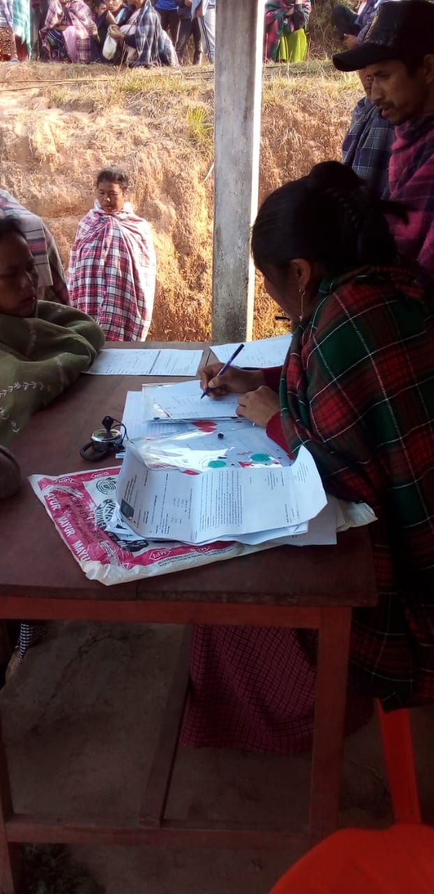
The District Team, AM- Environment Management, AM- Social Management, FE and two newly Staff of West Khasi Hills (PA Environment and AM- SM) joined the DPMU staffs as an orientation programme regarding the steps to be taken for smooth management of the project by them at their respective district. The sensitization programme held at a village Level to make the community aware on the Community Led Landscape Management Project (CLLMP) on the 13th December 2020.The villagers actively participated in the program, voicing out their concerns and questions regarding the project making it a huge success.
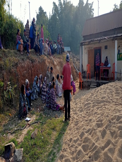
Fig: Villagers attending the Programme.
Highlights of the meeting:
1. Awareness about the Community Led Landscape Management Project (CLLMP).
2. Laying the importance on the involvement of the community in making the CNRM plan and its success.
3. A brief awareness on cleanliness was conducted based on our finding during the ground truthing phase.
4. An interactive session was held to answer doubts of the villagers regarding the project.
3. Signing of EOI, VGA and Green Charter:
On 13th December 2020, Nongtynniaw village signed the EOI (Expression of Interest), VGA (Village Grant Agreement) and the Green Charter after there was a uniform agreement by the people of the entire Community that the Community Led Landscape Management Project (CLLMP) be implemented at Nongtynniaw Village.
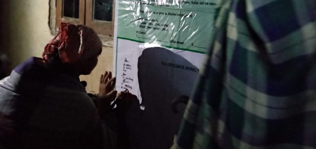
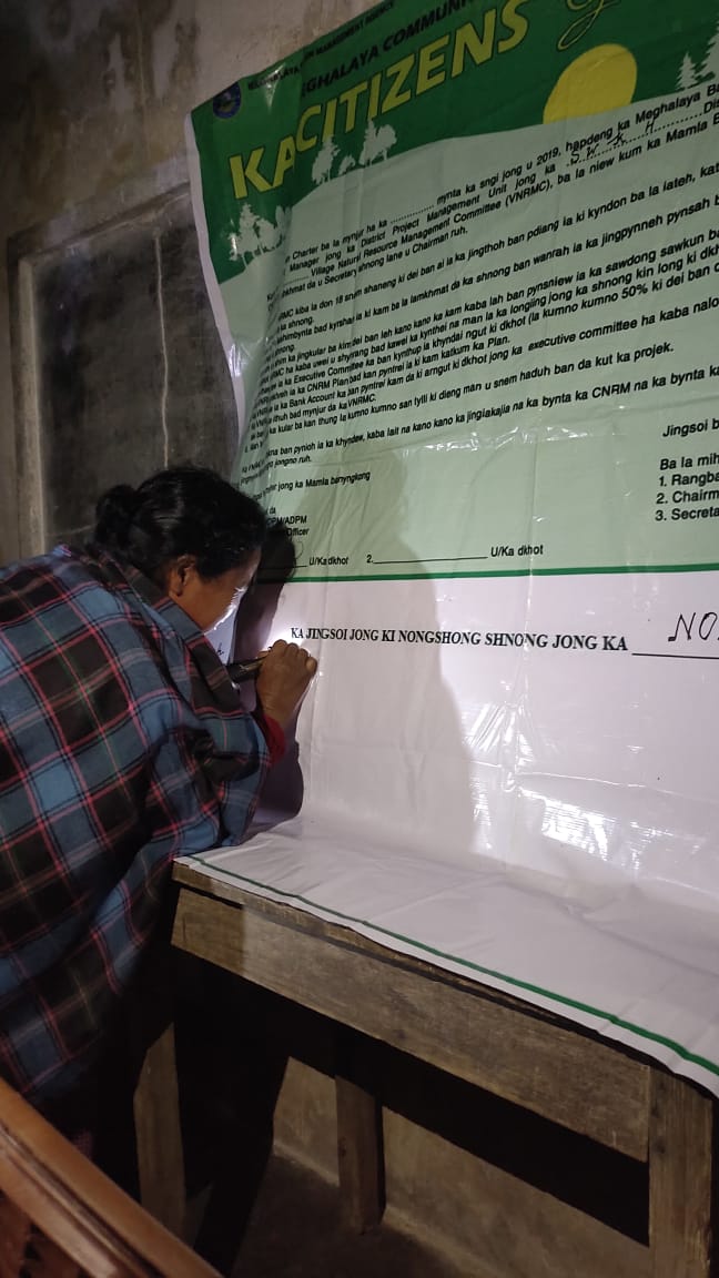
The people of Nongtynniaw participate in signing the Green Charter
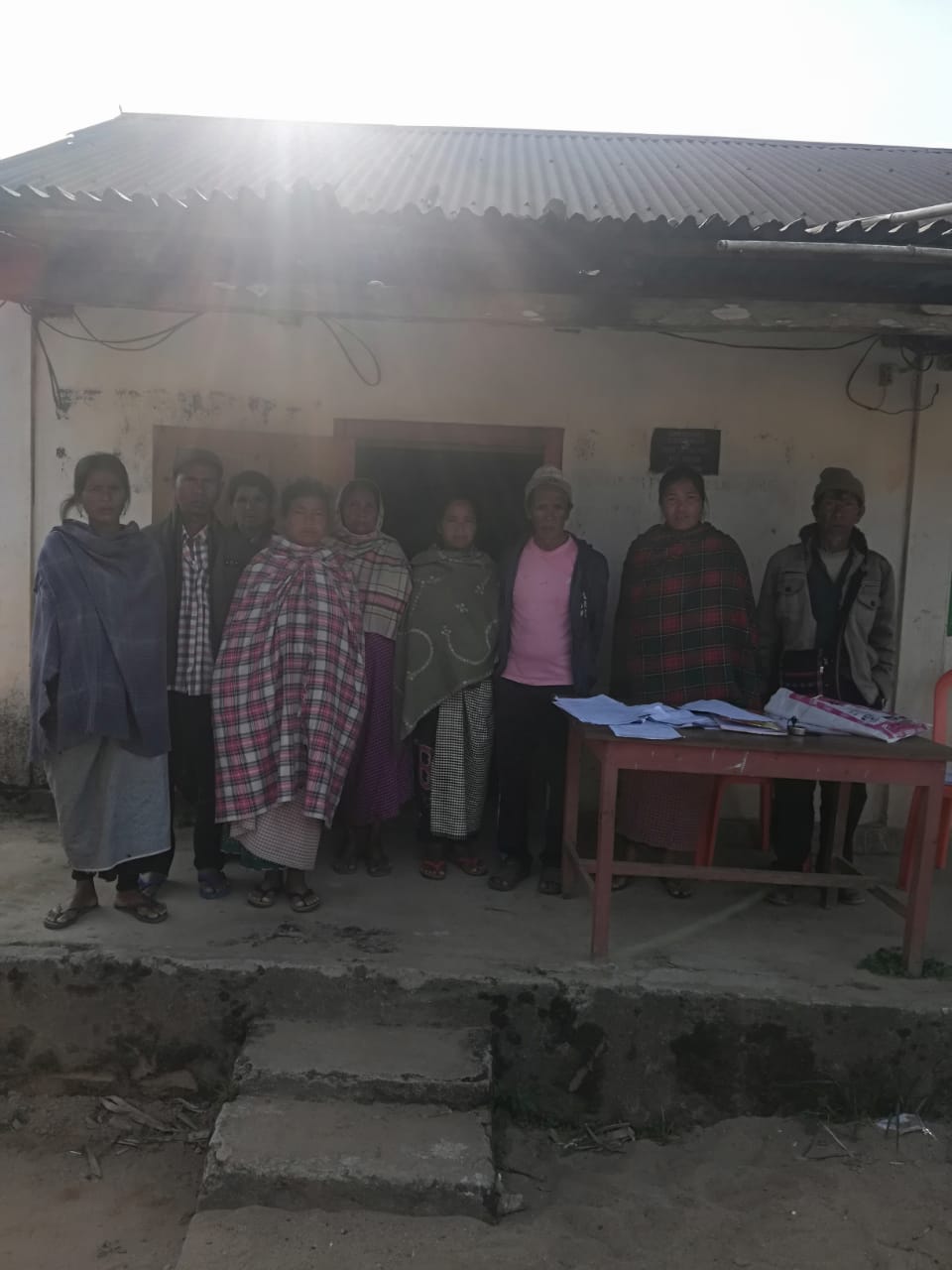
4. Formation of the VNRMC:
The formation of the Village Natural Resources Management Committee was done in a public meeting on the 13th December 2020 in the presence of the entire village and the CLLMP Staff. The people of the community chose the President, The Secretary, the Purchase Committee members and the other Executive members to form the Nongtynniaw VNRMC. There are 9 Executive members, 3 Village community Facilitator and 3 Purchase Committee members.
List below are the members of the VNRMC:
| Village Natural Resource Management Committee (9members committee constituted from Village Council, SHG group, Women’s group, youth, VEC) | ||||||||
|---|---|---|---|---|---|---|---|---|
| Sl No. | Name | Designation | Gender (M/F) |
Age in yrs | Qualification | Occupation | Community | Phone No. |
| 1. | Phimlandstar Thongni | President | Male | 50 | BA | Teacher | Khasi | 9402312140 |
| 2. | Phimtimorial Marthong | Secretary | Female | 27 | BA | Farmer | Khasi | 9436549409 |
| 3. | Clustar Marthong | Finance Secretary | Male | 42 | X | Farmer | Khasi | 9366790565 |
| 4. | Marius Thongni | Member | Male | 36 | VII | Farmer | Khasi | 6009140714 |
| 5. | Peter Wanniang | Member | Male | 27 | X | Farmer | Khasi | 7005493773 |
| 6. | Sharning Dkhar | Member | Male | 45 | I | Farmer | Khasi | 9402545136 |
| 7. | Philismora Marthong | Member | Female | 29 | X | Farmer | Khasi | 9485436138 |
| 8. | Elnestina Marthong | Member | Female | 46 | VII | Farmer | Khasi | NA |
| 9. | TitifuldaMarthong | Member | Female | 36 | VII | Farmer | Khasi | 9436354142 |
.
Fig: Executive Members of Nongtynniaw VNRMC
| Village Community Facilitators (VCF) | ||||||
|---|---|---|---|---|---|---|
| Sl no. | Name | Age | Gender | Qualification | Contact Number | Role |
| 1. | Daphiroy Marthong | 30 | Male | XII | 8787417689 | Documentation And KM |
| 2. | Joyfuldaris Marthong | 28 | Female | X | 6009556046 | Social And KM |
| 3. | Pynshailin Marthong | 23 | Female | XII | 9485164045 | Environment And KM |
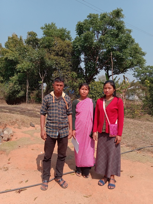
Fig: VCF of Nongtynniaw VNRMC.
| Procurement Members | |||||
|---|---|---|---|---|---|
| Sl no. | Name | Age | Gender | Qualification | Contact Number |
| 1. | Krestarlin Marthong | 65 | Male | X | |
| 2. | Oriallis Marthong | 30 | Female | XII | 9863544081 |
| 3. | Aibiris Marthong | 37 | Female | 8 | 9863371237 |
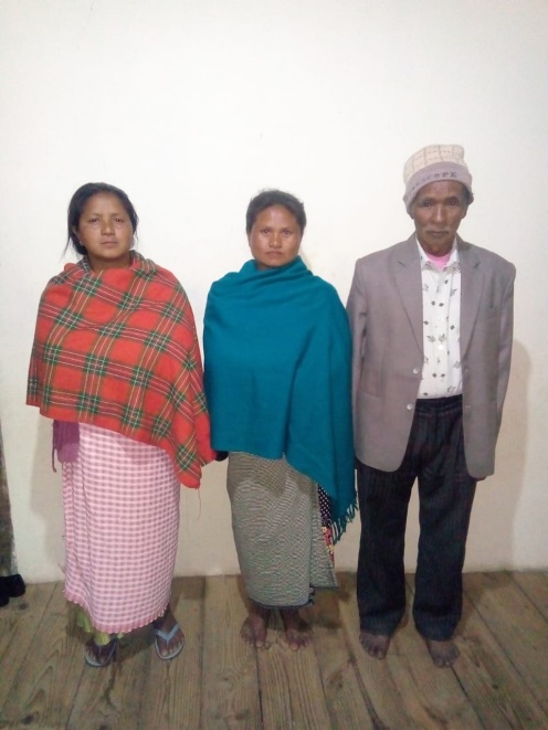
Fig: Procurement members of Nongtynniaw VNRMC.
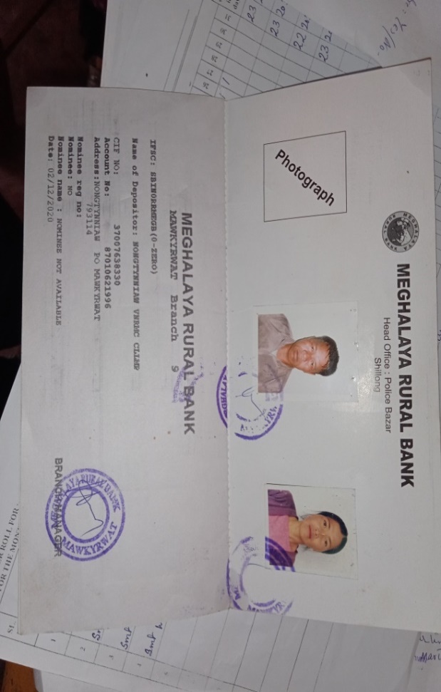
5. Opening of Bank Account:
The opening of the bank account was done on 02-12-2020 at Meghalaya Rural Bank (Mawkyrwat Branch), after the signing of the EOI (Expression of Interest), the VGA (Village Grant Agreement) and the signing of the Green Charter. The Accountant of CLLMP South West Khasi Hills trained the Purchasing and Procurement Committee of Nongtynniaw village on matters relating to Accounts and Book Keeping and on the:
Principles of Community Procurement
Benefits of Community Procurement
Important aspects undertaken by Community Procurement.
Procurement Process/Steps
Function of Purchase Committee
Important Procurement records to be maintained
 Financial limits and
methods
Financial limits and
methods
Maintaining of Books of Accounts to the Book Keeper.
Fig: Bank details of Nongtynniaw VNRMC.
6. Participatory Rural Appraisal Exercise:
The PRA exercise aims to incorporate the knowledge and opinions of the community in the planning and management of development projects and programmes.
The PRA exercise took place on the 13th December 2020, and around 50 villagers both men and women attended the program.
The District Project Manager gave the introduction and spoke about the different activities that the participants had to take part in the programme.
The Program Associate, Environment Management, spoke about the different CNRM plans and the different types of intervention. A group of participants interacted and helped in the collection of data based on the environmental template. With the help of this group, different sites of interventions was identified, analysed and evaluated in order to prioritized the areas that needed the natural resources management.
The Assistant Manager, Social Management, gathered the remaining group of participants to gather the baseline data bases on the social template.
The main objectives of PRA exercise is:
To identify the natural, human and economic resources of the village.
To identify the village problems and prioritized them with the help of the community members.
To prepare the community natural resources management plan of the village.
Findings based on the information gathered from the participants during the PRA/CNRMP exercise:
1. The main agricultural produce is Paddy, Wheat, Maize, Chilly and Potato.
2. Most of the household depend on firewood as a source of fuel.
3. Drinking water is limited over a period of 3-4 months during the winter season.
4. There are two types of forest ownership: Community and Private.
5. The springs which are present in the village needs rejuvenation.
6. Training on Land productivity, spring shed management and Community nursery is necessary for the village community.
7. There are no disputes/constraints encountered within the village community or with any neighbouring villages.
Priorities Intervention required based on the PRA Exercise:
1. Rejuvenation of the springs within the community through activities such as afforestation, treatment of catchment areas and contour trenches.
2. Afforestation, Bio-fencing and fire line control in the community forest.
3. Community Nursery for endemic trees.
4. A dug out pond for collecting rain water for.
5. Check dams for erosion control.
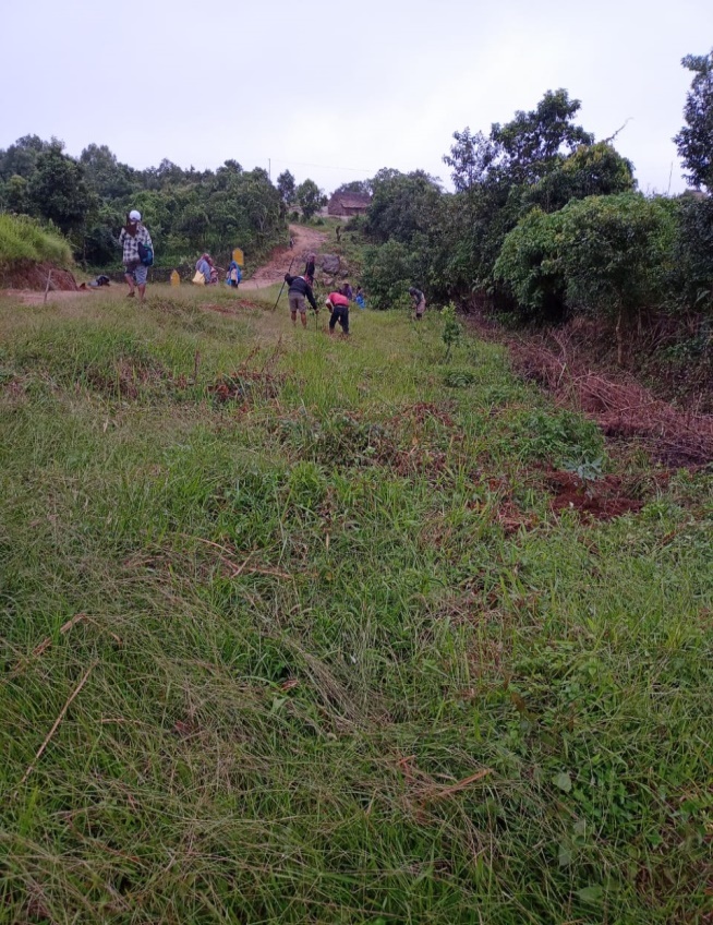
6. Afforestation and Roadside plantation.
7. Culturable wastelands to be brought under horticulture.
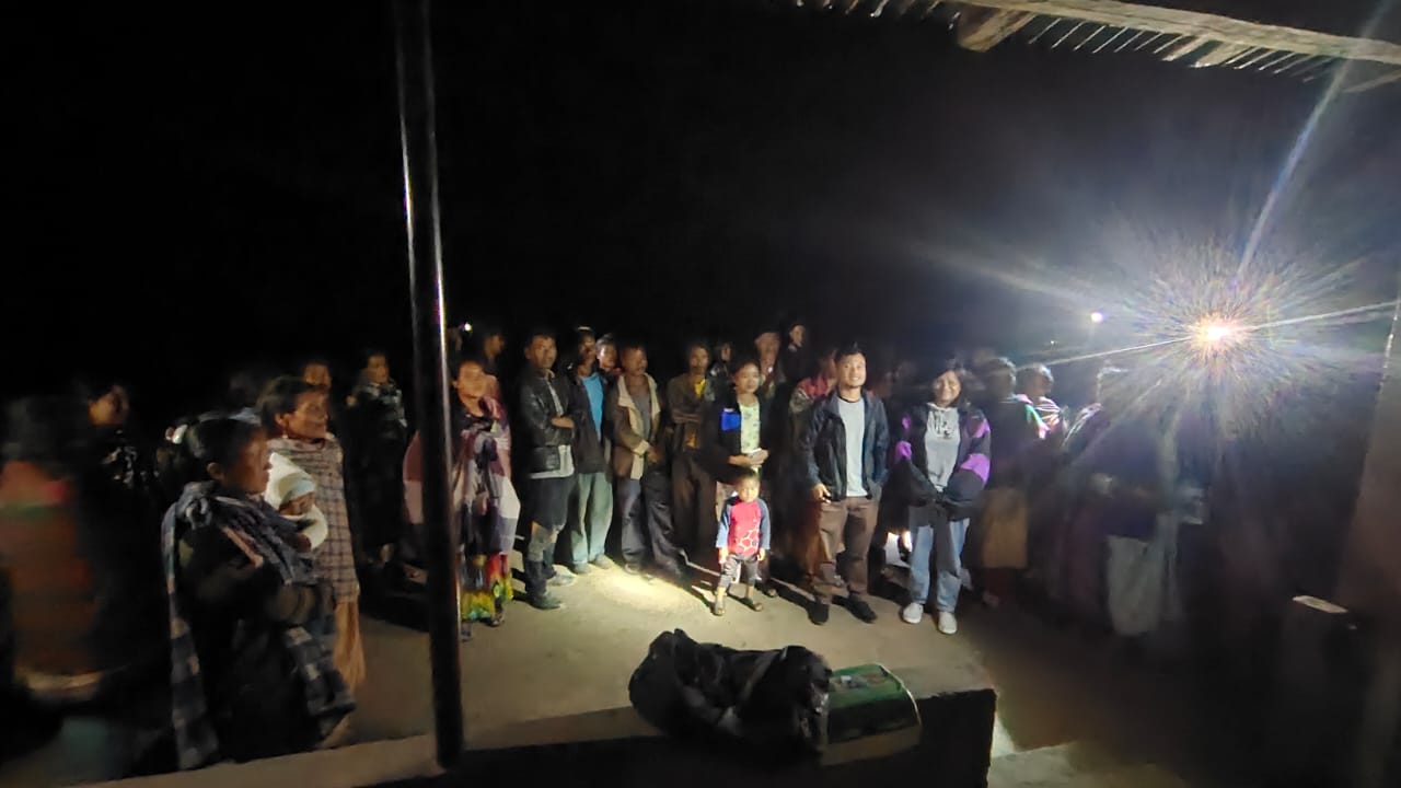
Fig: VNRMC members participating in awareness programme.
Baseline Data Survey to fill the Environment and Social Template:
During the PRA Exercise the External Expert of Social & Environment Management held a group discussion with the different groups to gather basic village information regarding number of households, demographic information, major crops and enterprises taken in the village, trends of production and productivity of major crops in the village and demographic distribution of village population.
Information related to land use category such as forest, cultivable land, water bodies, etc and the problems and challenges related to NRM were discussed.
Focussed Group Discussion on Problem Analysis:
1. Do people have sufficient access to supply of fodder, fuel wood, leaf litter?
Yes, people in the village have sufficient access to supply of fodder, fuel wood, leaf litter. They get it from the community forest and from their own private lands/forest.
2. Has access to timber improved or reduced over the years? How is access for household use and commercial use managed?
Access to Timber has reduced over the years. People have to purchase it from neighbouring village when needed.
3. Are the water bodies facing any threats?
So far the water bodies within the village have not faced any threats.
4. Do all people in the village have access to drinking water?
What are the challenges?
Yes, there is sufficient drinking water in the village except during
the winter season due to less discharge of water from the spring
source.
5. Are there degraded areas in the village (open/ degraded forests, mining affected, high soil erosion etc.)?
There are some minor degradation in cultivated land.
6. What has caused this degradation? Are there practices causing threats to availability and access to natural resources?
Fertility of the soil has decline over the year.
The practices that cause threat to the availability of these resources are :
Fires that take place every year
Excessive practice of Jhum Cultivation
7. What have been the changes in agricultural practices?
Yes, the area is not fertile anymore because of drought in the area.
8. Are there any challenges in farming?
The main challenges faced by the people of Nongtynniaw village are that over the years they have seen a decline in the soil productivity due to soil erosion.
9. How would you consider the health situation in your village?
The nearest health care which is the Sub-centre is near the village with a distance of 10 Km away and is easily accessible for the community as a whole to commute to the health centre.
10. How is the situation of cleanliness, sanitation, access to toilets and waste management?
The SHG member is responsible for organizing the cleaning drive once in a month.
Sufficient toilets are available in every household but most of the constructions are poor. Some households have access to toilets from SBM (Swash Bharat Mission) scheme. The presence of VWSC in the village has also improved sanitation and cleanliness. But Waste Management is poor because people are not really aware of how to properly disposed off waste.
11.Who are the most vulnerable in the village? What can be done to improve their lives?
BPL Families. Inclusion of BPL family members during project implementation
12. What are the livelihood aspirations of the youth? Are there any avenues available?
None, except daily wages labourers.
13. Do any committees/ institutions/ rules exist to manage and monitor natural resources in the village?
The VNRMC under the CLLMP is the main committee that is now in place to manage the natural resources in the village.
14.What are some of the major issues of conflict in the village?
Nothing related to NRM.
15.Have any of the above issues been discussed in village meetings?
Yes.
16. How do people resolve disagreements and conflicts?
All disagreements and conflicts are addressed by the traditional institution of village called the Village Durbar.
7. Village Boundary Mapping and Recourse Mapping:
The GIS personnel along with the Village Community Facilitators mapped the village boundary of Nongtynniaw Village with the apps provided by the office.
The village resource map is prepared by the people of the community. In this resource map, the local people prepare it by drawing it on chart paper. Recourses such as agricultural lands, wells, wastelands, cattle population, playgrounds, ICDS, churches, community halls, etc were mapped.
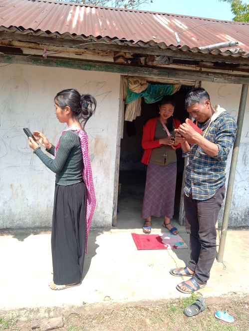
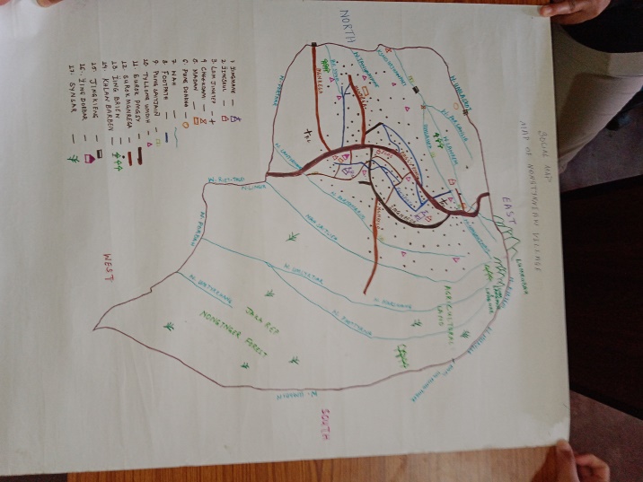
Fig:Resource map of Nongtynniaw village Fig:Assistinmg in village mapping by GIS.
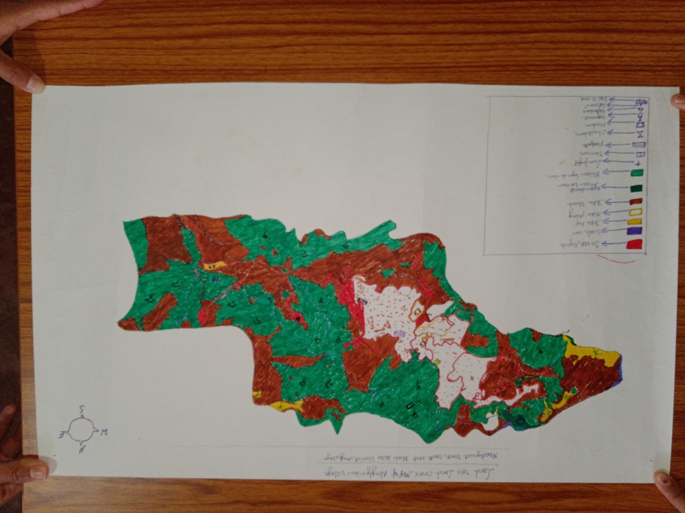
Fig: Land use land cover of Nongtynniaw.
Findings Based on the Resource Map of Nongtynniaw Village:
1. Main agriculture produce is Maize, Potato, Sweet potato and Paddy.
2. There are 2 Types of Forest ownership: Clan and Private Owned.
i) Clan Forest Lawsari,Lawkyndem, Lawbahnongtnger,Umsahang, Lumlangnar,Lumkubah,Lawpyngut
ii) Numerous Private Forest Umlaskot,Lawurem,Umthawai,Lawmarswang
3. There are culturable private wasteland - Doh japung, Twah sohiong , Phot lawsynrei.
4. There are rivers within Village Geographical area:Wahpyllieh, wahumlaskot
5. There are 5 streams flowing in the Village. Umsahep, Pursawlia, Pernongrim, Wahmarsiang, Umlarem.
6. There is 1 Community Hall in the village.
7. There is 1 Football playground.
8. Presence of Integrated Child Development Services (ICDS) through Anganwadi Centre (AWC).
9. There are 2L.P Schools and 1UP School within Nongtynniaw village.
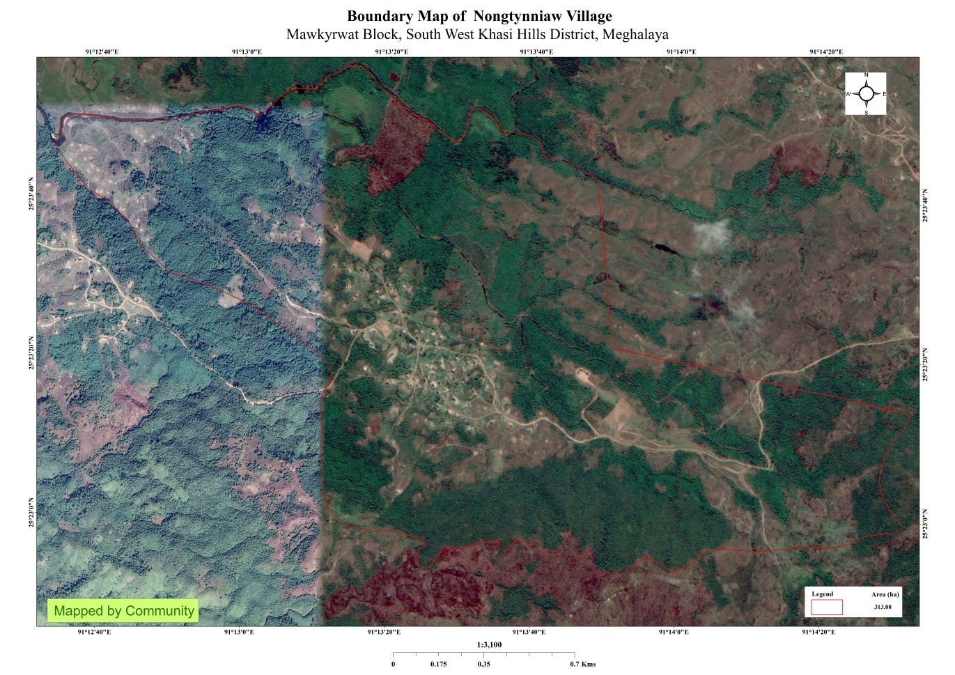
8.GIS Activities:
| Sl. No. | Parameters | Village Information |
|---|---|---|
| 1 | GPS Coordinates: | |
| i | Latitude | 25.389828 |
| ii | Longitude | 91.222226 |
| iii | Elevation Reading (MSL) | 1199 mm |
| 2 | Village Geographical Area (Ha) | 313.08 Ha |
| i | Total Forest Area (including community, Clan, Pvt Forest) | 150.45Ha |
| ii | Total Area of Water Bodies | 6.27Ha |
| iii | Total Area under Agri-Horticulture | 6.81Ha (agricultural only) |
| iv | Total Degraded land area (Ha) | 37.62Ha |
| 3 | Average Annual Rainfall | 12000mm |
| 4 | Soil Type | Loamy soil |
 .
.
Fig: Boundary Map and LULC Map of Nongtynniaw
9. The Proposed list of Interventions:
|
Name of proposed interventions | Site |
|
Nos of hhs expected to benefit | Priority (high/ medium/ low) | ||
|---|---|---|---|---|---|---|---|
|
|
|
|||||
| 1. | Check dam | Porsynri |
|
|
|
|
|
| 2. | Dugoutpond | Phot sharai | Private |
|
|
|
High |
| 3. | Spring chamber | Domkhmahiew | Private |
|
|
|
High |
| 4. | Roadside plantation |
|
Private |
|
|
|
High |
| 5. | Spring chamber | Phot sla pet | Private |
|
|
|
High |
| 6. | Spring chamber | Lawliengskor | Private |
|
|
|
High |
| 7. | Loose boulder | Porthar | Private |
|
|
|
High |
| 8. | Community nursery | mawpombyrthat | Private |
|
|
|
High |
| 9 | Vermi compost | mawpombyrthat | Private |
|
|
|
High |
| 10 | Dug out pond | Phot thaw kie | Private |
|
|
|
High |
| 12 | Dug out pond | Dom thung khla | Private |
|
|
|
High |
| 13 | Cc dam | Porthar | Private |
|
|
|
High |
10. Project Implementation:
| 1. | Type Of Intervention | Site Name | GPS Co-ordinates | Amount Sanctioned | Work Status | |
|---|---|---|---|---|---|---|
| ROADSIDE PLANTATION | POR NONGRIM | 25.38770167 | 91.222941 | ₹ 25415/- | On going | |
.
Fig:Roadside plantation at Por Nongrim
| 2. | Type Of Intervention | Site Name | GPS Co-ordinates | Amount Sanctioned | Work Status | |
|---|---|---|---|---|---|---|
| SPRING CHAMBER | AT LAWLIENGSKOR | 25.387089 | 91.22297 | ₹ 44,500/- | Completed | |
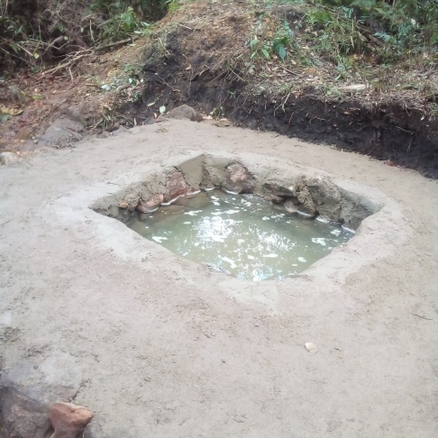
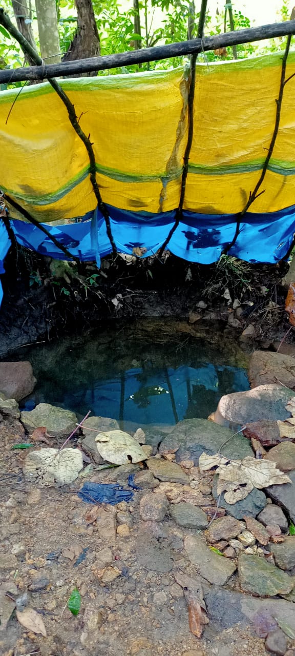
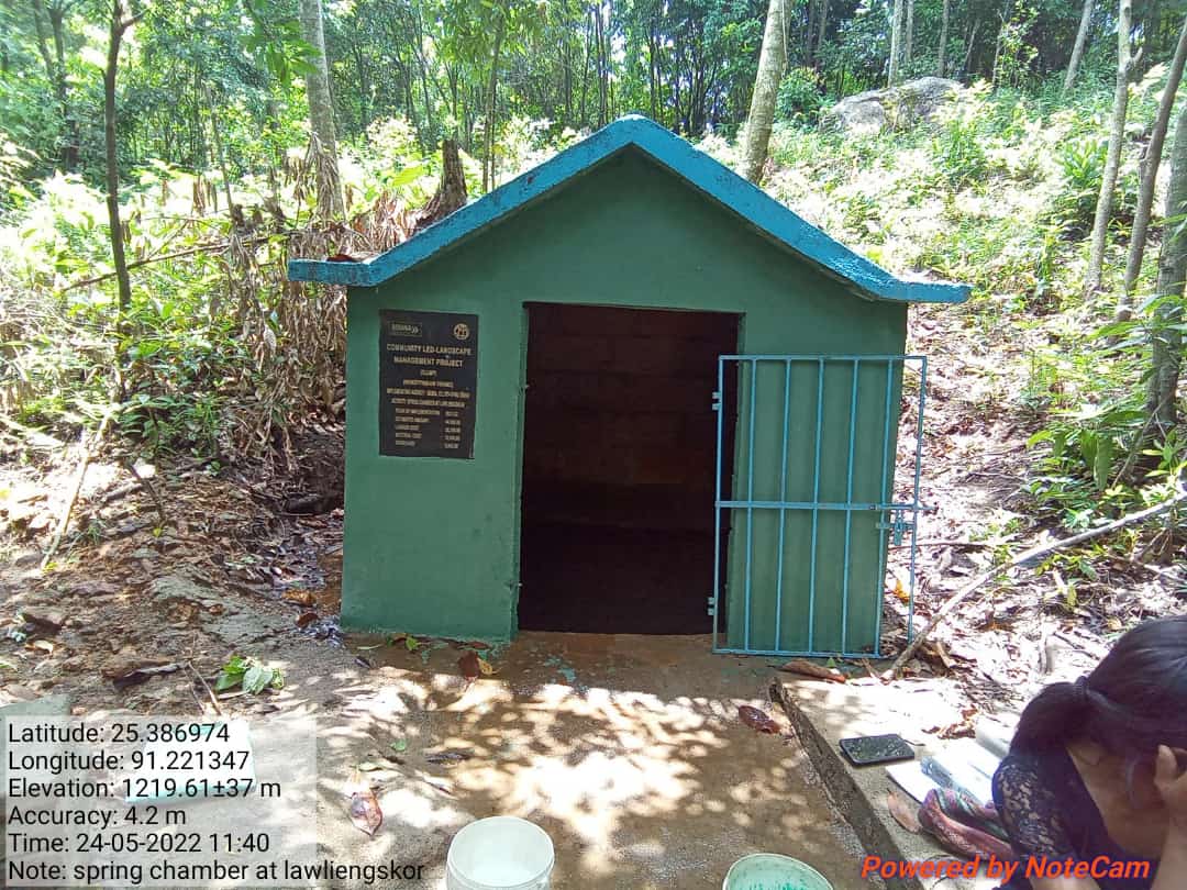
Fig: SPRING CHAMBER AT LAWLIENGSKOR
| 3. | Type Of Intervention | Site Name | GPS Co-ordinates | Amount Sanctioned | Work Status | |
|---|---|---|---|---|---|---|
| SPRING CHAMBER | DOMKHMAHIEW | 25.390397 | 91.225421 | ₹ 36,000/- | Completed | |

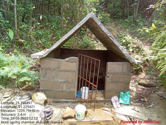
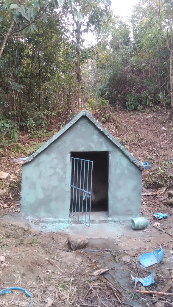
Fig: SPRING CHAMBER AT DOMKHMAHIEW
| 4. | Type Of Intervention | Site Name | GPS Co-ordinates | Amount Sanctioned | Work Status | |
|---|---|---|---|---|---|---|
| SPRING CHAMBER | PHOTSLAPET | 25.392348 | 91.219842 | ₹ 36,000/- | Completed | |
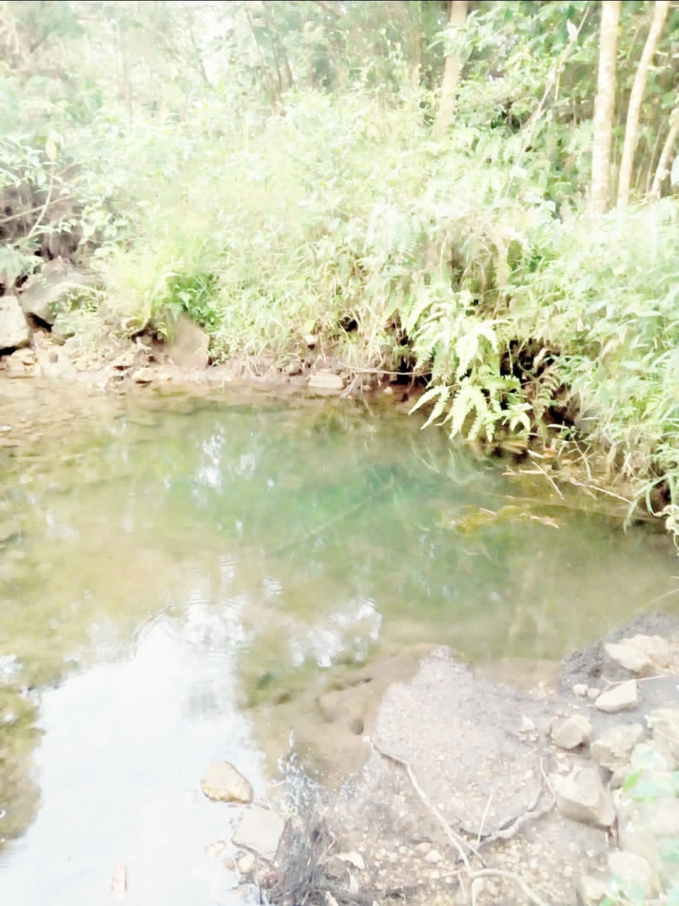
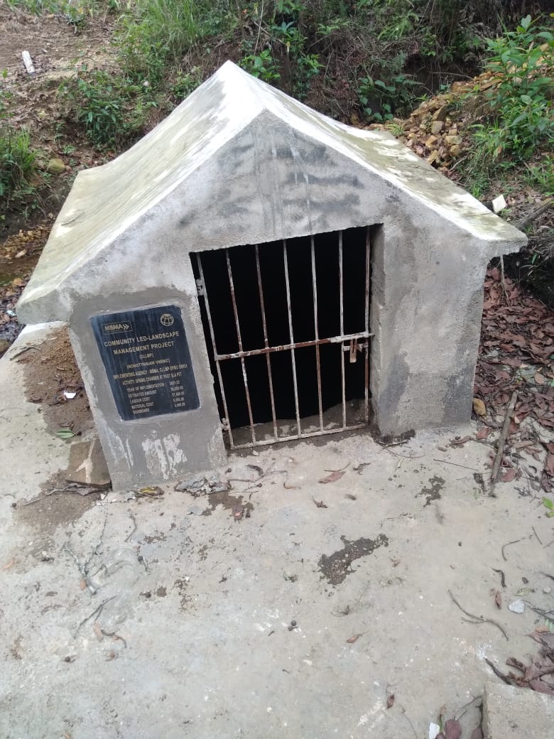
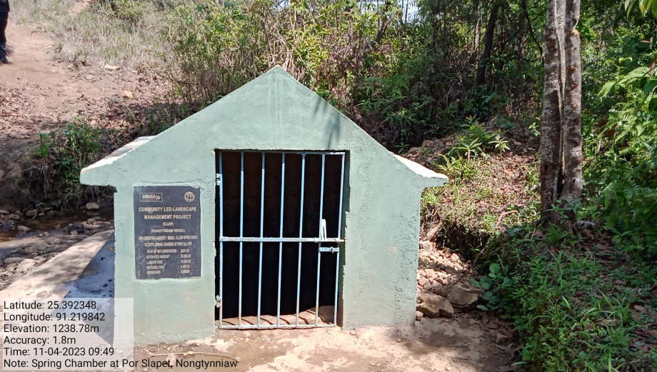
Fig: SPRING CHAMBER AT PHOT SLAPET
| 5. | Type Of Intervention | Site Name | GPS Co-ordinates | Amount Sanctioned | Work Status | |
|---|---|---|---|---|---|---|
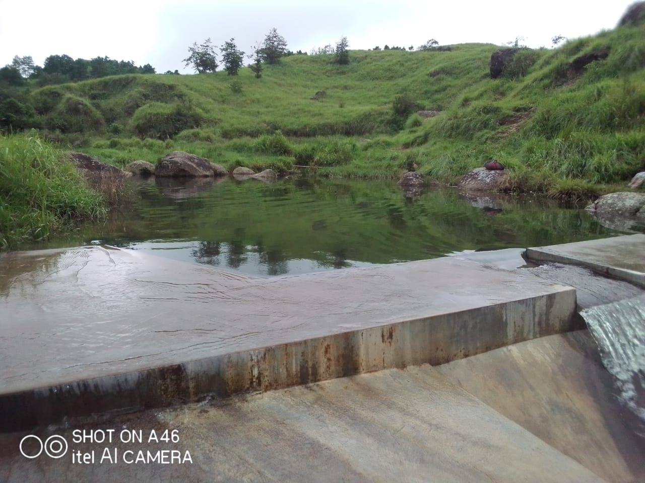
| CHECK DAM | PORSYNRI | 25.394501 | 91.435357 | ₹ 5,85,550/- | Completed | |
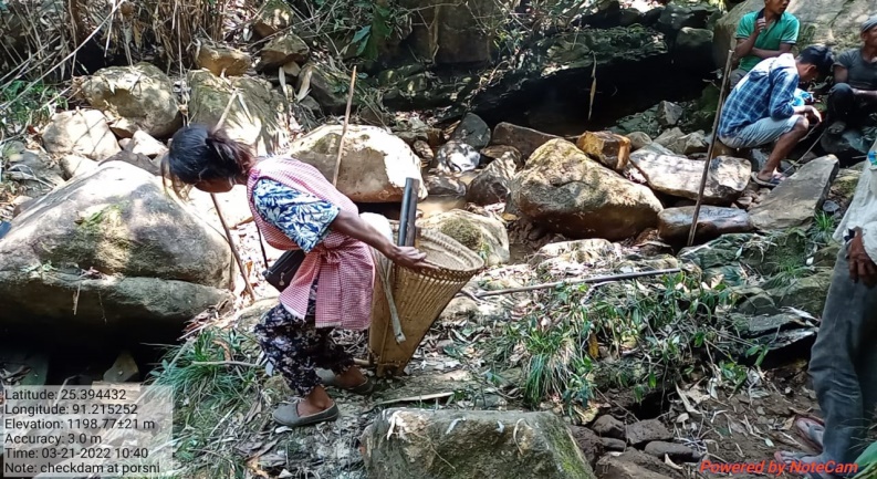
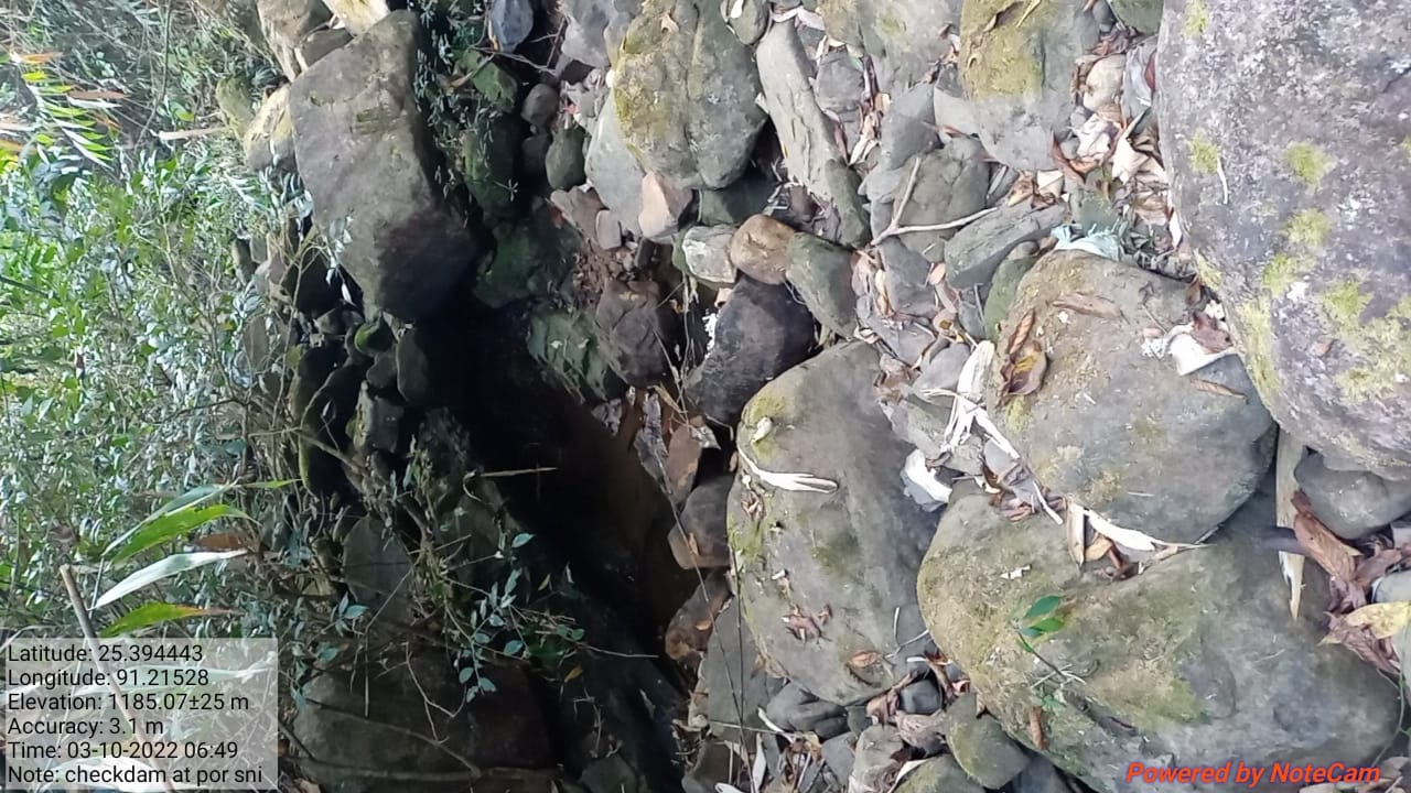
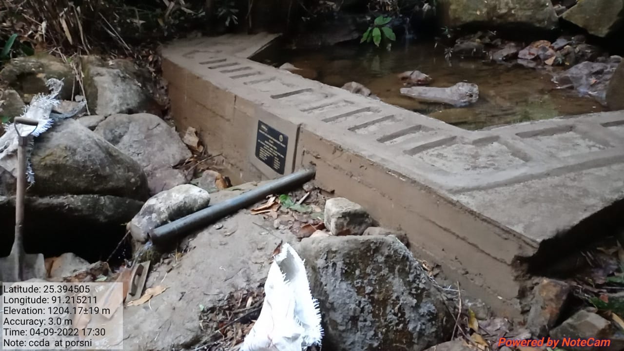
Fig: CHECK DAM AT PORSYNRI
| 6. | Type Of Intervention | Site Name | GPS Co-ordinates | Amount Sanctioned | Work Status | |
|---|---|---|---|---|---|---|
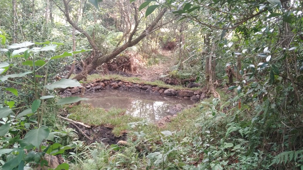
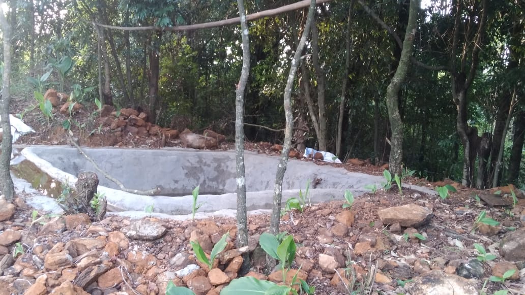
| DUGOUT POND | Nongtynniaw | 25.389745 | 91.222823 | ₹ 64240 /- | Completed | |
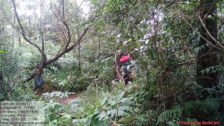
Fig: Construction of Dugout Pond at Nongtynniaw
| 7. | Type Of Intervention | Site Name | GPS Co-ordinates | Amount Sanctioned | Work Status | |
|---|---|---|---|---|---|---|
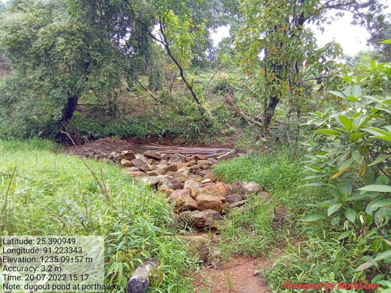
| Dug Out Pond | Phot Thaw Kie | 25.390949 | 91.223343 | ₹ 64240 /- | Completed | |
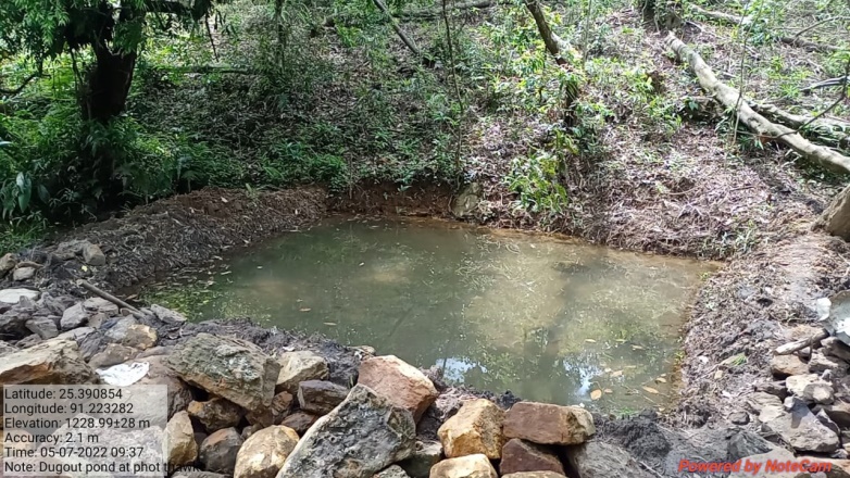
Fig: Construction of Dug out pond Phod Thawke
| 8. | Type Of Intervention | Site Name | GPS Co-ordinates | Amount Sanctioned | Work Status | |
|---|---|---|---|---|---|---|
| Dug Out Pond | DomThung Khla | 25.387639 | 91.222543 | ₹ 40,770/- | Completed | |
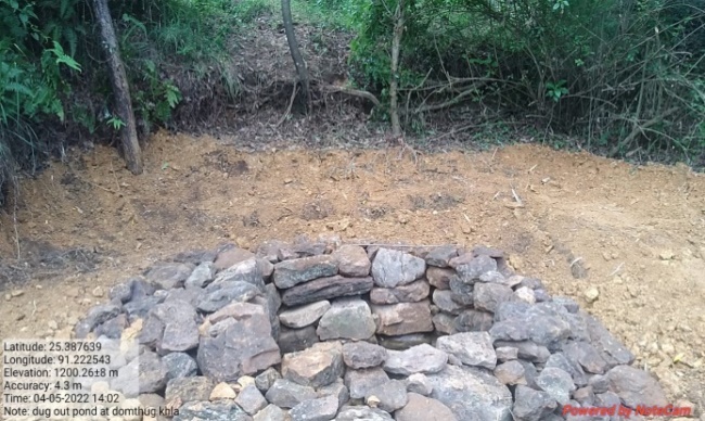
Fig: Construction of Dug out pond Dom Thungkhla
| .9. | Type Of Intervention | Site Name | GPS Co-ordinates | Amount Sanctioned | Work Status | |
|---|---|---|---|---|---|---|
| Loose Boulder bund | Porthar | 25.393395 | 91.212325 | ₹ 28530/- | Completed | |
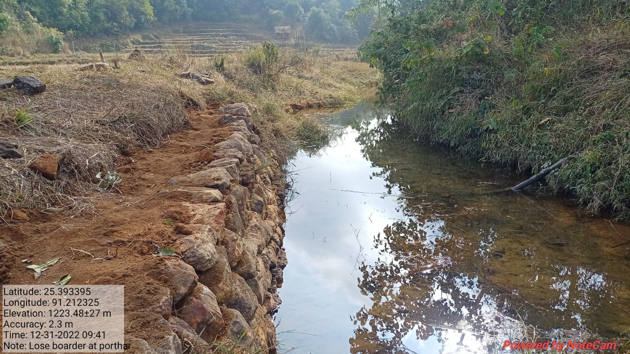
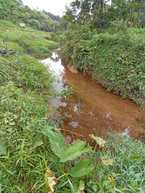
Fig: Construction of Loose boulder bund at Porthar
| .10. | Type Of Intervention | Site Name | GPS Co-ordinates | Amount Sanctioned | Work Status | |
|---|---|---|---|---|---|---|
| C.C Dam | Porthar | 25.390854 | 91.214131 | ₹ 470170/- | Completed | |
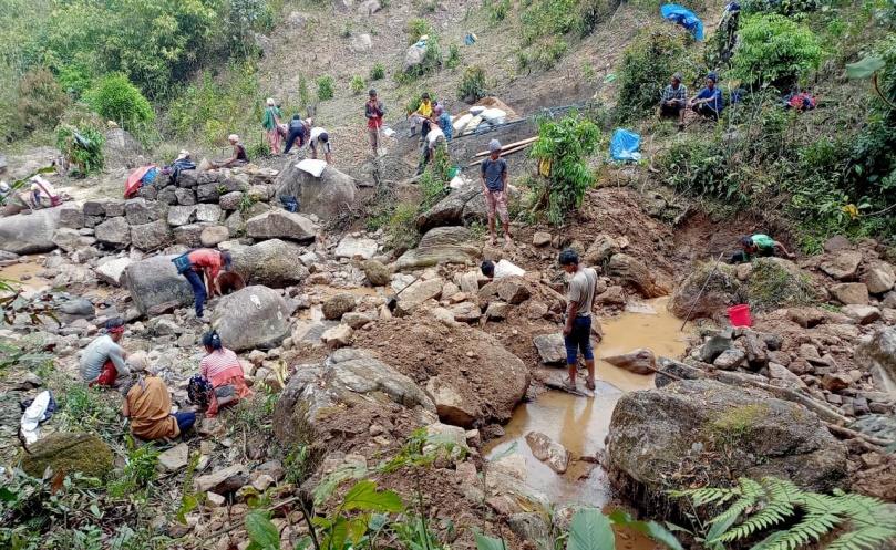
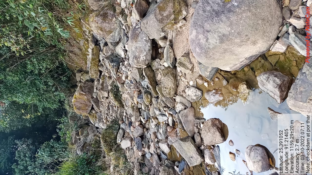
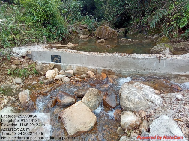
Fig: Construction of CC Dam at porthar
| .11. | Type Of Intervention | Site Name | GPS Co-ordinates | Amount Sanctioned | Work Status | |
|---|---|---|---|---|---|---|
| Community Nursery | Mawpombyrthat | 25.392262 | 91.218933 | ₹1,64,950 /- | On going | |
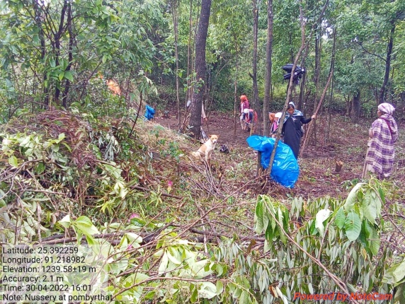
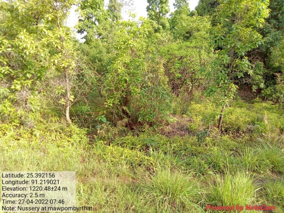
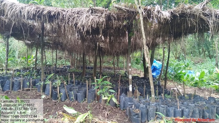
Fig: Community Nursery
| 12. | Type Of Intervention | Site Name | GPS Co-ordinates | Amount Sanctioned | Work Status | |
|---|---|---|---|---|---|---|
| Vermi Compost | Mawpombyrthat | 25.32305 | 91.218948 | ₹ 27,625 /- | Completed | |
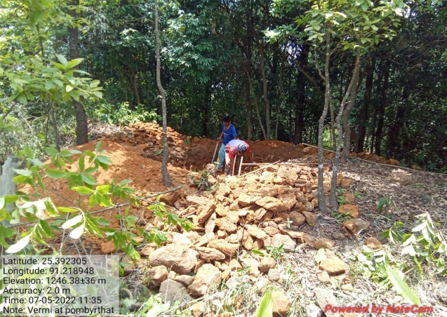
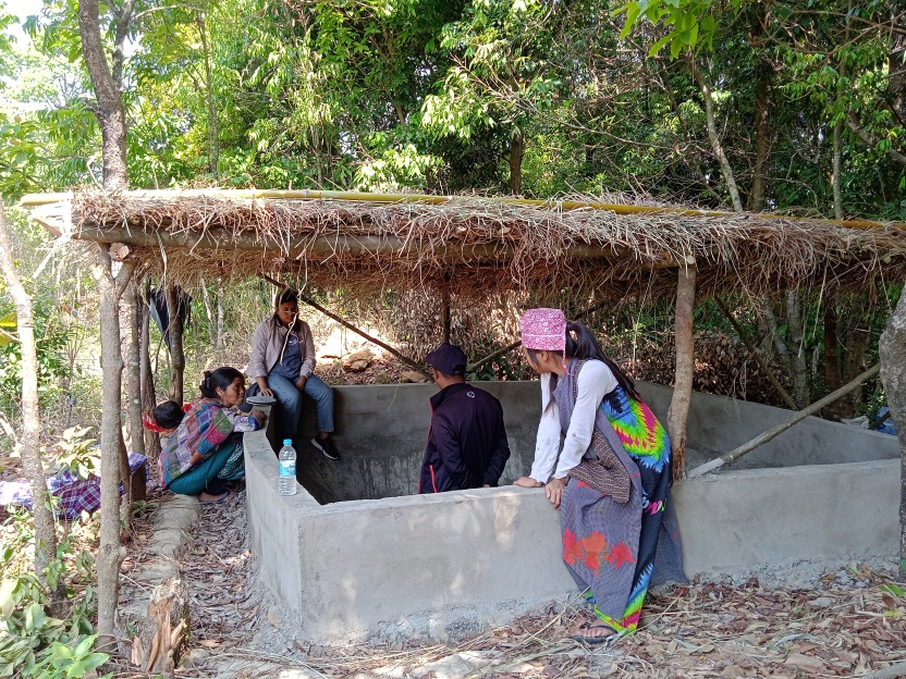
Fig: Vermi Compost
| 13. | Type Of Intervention | Site Name | GPS Co-ordinates | Amount Sanctioned | Work Status | |
|---|---|---|---|---|---|---|
| CC Channel | Porthar | 25.39111 | 91.214025 | ₹5,67,010 /- | Completed | |
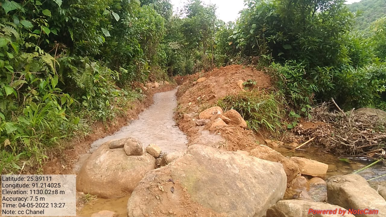
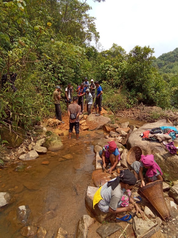
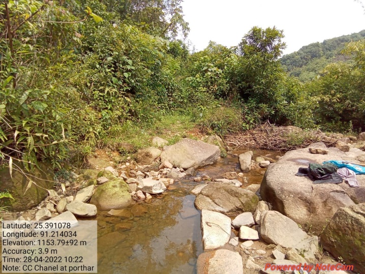
Fig: Construction of Cement Concrete Channel at Porthar
11. Fund Status:
Fund Released to VNRMC (Project Implementation) |
Total No. of Work order Issued | Activity Name | Amount Sanctioned by CLLMP | Work Order Issued Date | Start Date | End Date |
|---|---|---|---|---|---|---|
| ₹21,55,000 | 13 | ROADSIDE PLANTATION AT PORNONGRIM | ₹25415 | 12th July 2021 | 02-Aug-21 | 12-Jan-22 |
| SPRING CHAMBER AT LAWLIENGSKOR | ₹44500 | 12th July 2021 | 01-Oct-21 | 22-Oct-21 | ||
| SPRING CHAMBER AT DOMKHMAHIEW | ₹36000 | 12th July 2021 | 01-Oct-21 | 28-Oct-21 | ||
| SPRING CHAMBER AT PHOT SLA PET | ₹36000 | 12th July 2021 | 01-Oct-21 | 27-Oct-21 | ||
| Dug Out Pond at Phot Thaw Kie | ₹64240 | 15th Nov 2021 | 13-Sep-22 | 15 Sep 2022 | ||
| Dug Out Pond at Nongtynniaw | ₹64240 | 15th Nov 2021 | 8th Aug 2022 | 22nd Oct 2021 | ||
| Dug Out Pond at Dom Thung Khla | ₹40770 | 15th Nov 2021 | 24-Aug-22 | 29th Oct 2022 | ||
| Loose Boulder Bund at Porthar | ₹28530 | 15th Nov 2021 | 12-Sep-22 | 18th Mar 2022 | ||
| CC Dam at Porthar | ₹470170 | 14th Dec 2021 | 01-Feb-22 | 24-Mar-22 | ||
| CC Dam at Porsynri | ₹585550 | 14th Dec 2021 | 01-Feb-22 | 25-Mar-22 | ||
| Community Nursery at Mawpombyrthat | ₹164950 | 25th Feb 2022 | 12-Apr-22 | 30-Apr-22 | ||
| Vermi Compost at Mawpombyrthat | ₹27625 | 25th Feb 2022 | 12-Apr-22 | 19-May-22 | ||
| CC Channel at Porthar | ₹567010 | 25th Feb 2022 | 14-Apr-22 | 30-May-22 |
GROUND TESTIMONIALS:
Ms. Pynshailin Myrthong
VCF Envt Nongtynniaw
From this Project I have been benefitted personally as I can test the quality of the water, pH level, water discharge, etc., with the water tracer and fill the information on the Spring Survey App which I do monthly. I also follow up quarterly on the survival rate of all plantation works and as being taught by the Staffs and External experts, I have learned the use of Note Cam App whenever I go for site visitation. I feel blessed to have worked with this office that oversees the development and management of the natural resources within the village.