VILLAGE PROFILE
OF
NONGUMMER VILLAGE
UNDER MAWKYRWAT C&RD Block
District: SOUTH WEST KHASI HILLS
COMMUNITY LED LANDSCAPE MANAGEMENT PROJECT


The Government of Meghalaya with financial help from the World Bank is implementing the Meghalaya Community Led Landscape Management Project (MCLLMP). The project will cover the entire state of Meghalaya and implementation of community led plans will be rolled out in phase manner throughout the state. The Meghalaya Basin Management Agency (MBMA) will facilitate community-led planning by providing support, technical inputs and funding.
The project is intended to strengthen community-led natural resources management in selected landscapes within the 12 districts of the state. This would be achieved through a variety of planning, capacity building, and on-the-ground interventions to promote the conservation, sustainable use of natural resources, social inclusion and community mobilisation; building traditional knowledge and learning, mapping of natural resources management; strengthening the community institutions and creating linkage with financial institutions and community organizations.
The project interventions will include preparation of community led natural resource management plans. The CLLMP has the following three components:
Strengthening Knowledge and Capacity of Communities for Natural Resources Management
Community-Led Landscape Planning and Implementation
Project Management and Governance
The project objective is “to manage and conserve the natural resources, especially forests, soil and water sources, in a manner that supports the financial and physical well-being of communities in the State”
SCOPE:
The CLLM-Programme focuses on increasing the capacities of communities and traditional institutions (TI) by adopting a landscape approach to manage their natural resources such as soil, springs and other water sources, forests and bio-diversity, etc.
The project will be planned and implemented in about 400 villages across the state.
CLLMP has a strong focus on institution-building at the village-level, by ensuring systematic capacity-building on technical and social skill-sets.
The project will also extend such training to communities beyond the targeted villages and support efforts made by them to access funding from various rural and natural resources initiatives and schemes.
The programme will also invest in improving the process and outcome delivery, by developing and adhering to effective systems and procedures, supported by the appropriate technology.
BENEFITS:
Benefits for community (Skills and Capacity relating to technical and managerial areas like NRM and Conflict resolution
Benefits to traditional institutions (village councils, traditional leaders, community-based organizations, SHGs etc) through Knowledge sharing, promotion of innovative approach, access to technology, technical managerial and financial support.
It is estimated that the project will impact around 1 lakh partners (of which 50% are women) who depend on land, forest, agro forestry.
Through the project, 55000 Ha of targeted area will be ensured with availability of water, biological resources and soil productivity, which will in turn benefit around 400 villages and the outcomes delivery can be summarized as follows.
IMPLEMENTATION AGENCY:
The Project will be executed by the MBMA in collaboration with other partners particularly, SIRD (for training and capacity building), Department of Soil and Water Conservation, Water Resource Department, Forest Department, specifically with respect to technical inputs, safeguards management and Community NRM plan preparation.
PROJECT PERIOD:
2018-2023 (5 years)
TABLE OF CONTENTS:
Introduction and History……………………………………………. 5-7
Social Profile ……………………………………………………… 7
Village Accessibility…………………………………… 7
Literacy rate……………………………………………. 7-8
Population……………………………………………... 8
Occupation…………………………………………….. 9
Village organisation……………………………………. 9
Fuel Type……………………………………………… 9
Drinking Water………………………………………... 9
Cultivatible Land……………………………………… 10
Forest Cover……………………………………………. 10
Forest Species…………………………………… 10
Water Bodies………………………………………… 10
Areas affected………………………………………….. 10
III. CLLMP Activities
Ground-Truthing…………………………………………… 10-11
Sensitization on CLLMP…………………………………… 11
Signing of EOI, VGA and Green Charter………………………. 11
iv. Formation of VNRMC…………………………………………... 11-12
Village Community Facilitators………………………………… 13
Purchase Committee ……………………………………… 14
IV. Opening of Bank Account …………………………….……………….. 14
V. PRA Exercise…………………………………………………………… 15-16
Basic Survey for CNRMP template…………………………… 16
Focussed Group Discussions…………………………………… 16-17
Village Boundary Mapping and Resource Mapping…………… 18
VI. GIS Activities…………………………………………………………… 18-19
VII. The Proposal list of intervention………………………………………… 19-22
VIII. Project Implementation ………………………………………… …….. 23-50
IX. Fund Status ……………………………………………………………… 51-53
X. Ground Testimonials……………………………………………………. 54-55
INTRODUCTION:
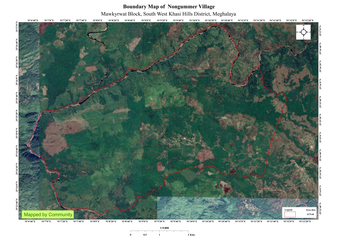
Nongummer is a village located in Mawkyrwat Block of South West Khasi Hills district in Meghalaya. Positioned in rural area of South West Khasi Hills district of Meghalaya,
Nongummer Village is situated in South West Khasi Hills District under the Mawkyrwat C&RD Block 64 Km away from the District Headquarters i.e. Mawkyrwat and about 65 Km away from the Block Headquarters. It has a total geographical area of 3279.68 ha and falls under the Hima Maha Nongstoin. Nongummer village has a total population of 600 comprising of 295 males and 305 females. All the residents of Nongummer village belonged to the Khasi Scheduled Tribe. The average rainfall of Nongummer village is 1200mm and the type of soil is mainly loamy soil.
BRIEF HISTORY ABOUT THE VILLAGE:
“A brief story of Nongumer Village by Franklin Lyngdoh,ex-secretary”
In the olden days within the boundaries of the now Nongummer village people came and settled in the north-western part of the now Nongummer village. The name of this village is long forgotten and nowadays it has been given the name “Langshmang”. According to stories passed down through generations the Marshra, the Sangriang and the Marthong clans made their way into that area and began agriculture and cattle rearing.
According to stories told to us by elders there arose contentions between the Nongstiin clan and the Nongrtong clan (that means that the Syiem Nongstiin clan and the Kharbani clan in Nongrtong village,but now this village is no more). Due to the contentions war broke out between the two. During the war the ‘Kharbani clan of Nongrtong’ began to lose power, weaken and they were slaughtered by the Nongstiin. Therefore, the Kharbani sided with the Nongsymbei clan (Lawse as known today) to ask for help. The Nongsymbe were ready to help the Kharbani mainly because they were archers and warriors. With the help of the Nongsymbe, the Nongrtong were able to breathe a sigh of relief in the war against the Nongstiin and the Nongstiin were frightened and began to retreat. When the Nongstiin got information that the Kharbani and the Nongsymbe were working together they planned to ambush the Nongsymbe in the middle of the night while they were returning back to their village. With this plan the Nongstiin easily slaughtered the Nongsymbe in the middle of their path before reaching the village (Jurlawse as is known today). In a fury the Nongstiin slaughtered both men and women. The Kharbani and the Nongsymbe that had no means to fight back managed to escape in panic into the jungle to hide from imminent death. Then, at this moment they decided they would flee their village. The Nongsymbe were able to rescue only a small baby girl child (Khonleng) that survived the slaughter because the mother managed to hide the child but the mother was killed. The men and women of Kharbani clan that survived fled with the Nongsymbe and abandoned their village (Lawse) because they feared the Nongstiin.
While they fled, they reached the village Sangriang at dawn and in that moment the rescued baby began to cry loudly and cannot be calm down for the child was hungry and yearning for its mother. All of them were in terror for if the Nongstiin were following them they were sure to be found because of the baby’s cry. They reached a small hut while it was still dawn and they left the baby there and beg the hut’s owners to take care of the child for a while until they came back. From here they head straight till Wah kynshi (Wah-river), crossed it and they reached the foothills of Lum Niangram. They planned to head straight to Rilang but the people in Niangram didn’t allow and blocked their paths. Then they went eastwards from Niangram and reached Langkynniaw (north from Nongummer). Then they rested to rethink about where they would go. While they are consulting among themselves and performing rituals to their gods, the gods answered and advised them to settle in this place.
Both clans (Kharbani and Nongsymbe) were satisfied and settled there. They didn’t venture here and there for fear that the Nongstiin would come to know about their whereabouts. To provide for their needs they choose from among themselves men that would go to the markets in Rilang with false names and surnames in an effort to conceal themselves from their pursuers. In this way they survived for many years in Langkynniaw. Years passed and they felt at ease again and the Nongsymbe decided to go back for Leng (They left the baby in Nongsangriang, but now she is in her youth). Here, in Langkynniaw both the clans wed clans from nearby villages and among themselves and grew in numbers.
These people from Langkynniaw farm crops in the fields south of their village on the other side of Wah Rukhon and benefitted greatly from their agricultural produce so much that they desired to own the land on which they farm but a person by the name “Perleng”of the Marsha clan won’t allow the people from Langkynniaw to claim the land as according to him the land belong to his wife of the Sangriang clan. This Perleng is one of the nongknia bylle (shaman or witch doctor) who was extremely feared during those days. The people from Langkynniaw were afraid to challenge him. At times when Perleng was angry with anyone he’d cast various spells and curses upon them which even led to their death.
One summer when Perleng was in a meditation state for forty days and forty nights a thunderstorm came with a huge downpour which caused the water level to reach the underside of his house. This led to “doh jei” fishes arriving around his house and laying their eggs inside his drinking water source. His wife and his children were fetching water and some “doh jei” were accidently caught and they unknowingly ate them. When Perleng awoke from his meditative state he found out that his wife and children ate the “doh jei” which were actually the children of his gods. In a fit of anger Perleng cursed his wife and children and said they would be better off dead for they had ill-treated the children of his gods so much so that the gods now had abandoned him. Because the gods had abandoned him all his rituals and witchcrafts now were of no effect and useless. He was in disgraced and went inside a hole in the ground near his house never to resurface again. His wife and children because of the curse Perleng placed on them died one by one until but one small child was left and was in a state of illness. No one was there to show pity or take care of the child. The Kharbani who were the paternal relatives (ki khabah) of this child came and took the child and cared for it till whatever days the child had left to live. As the caretakers of that child that place which was the land of the Sangriang clan who now had died off was given to the Kharbani.
When Perleng died the Kharbani, the Nongsymbe and other clans from Langkynniaw were able with ease to crossed Wah Rukhon to farm in the area there without being disturbed. From among the different clans in Langkynniaw a widow by the name Wirlait Nongsymbe was the first to build a house in this land where she raised her cattle and grew crops. (Wirlait was the daughter of Lait Thma who was the daughter of Thma Leng who was the daughter of Leng) Then other clans settled on this side of Wah Rukhon in the land which was given to the Kharbani by the Sangriang clan that have died off. These clan had now altogether abandoned Langkynniaw . All of the inhabitants build their houses only upon two small hills and this area is now called “Mawthengkhla”. In this place they multiplied and whatever work they did prosper without much loss. In this place there is only one source of drinking water and when winter season arrived the water source always dried up which worried them. They dug different water wells but come winter they dried up as well. One day they decided to search for water somewhere else even if this new source is far so that they won’t suffer from water shortage during winter seasons. After sometime they stumbled upon a small stream (sawah im um) and dug there for a new water source. This new dug well filled up with water and in the winter season it didn’t dry up but always overflowed. They never faced anymore water shortages. From then onwards this new water source was called “Umtongbah” and their old water source was called “Umtongjan”. They used to call Umtongbah as “Im-mer” which means that it always full of water in summer and winter. Also, all around the surrounding of this place they sow crops and farm various plants and whatever seed they plant, always bore fruit. ‘U im u mer’ which means a plant or crop that germinates and is healthy. The word ‘Mer’ is a Nongummer word which means a grown healthy strong plant or crop. They called that crop field ‘NONG-IM-MER’ because the area was fertile.
In this way the name of the village NONGUMMER is derived.
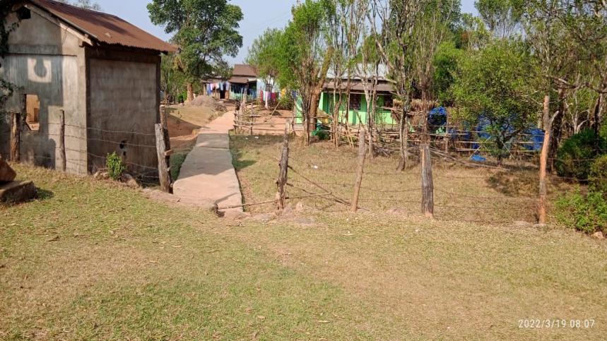
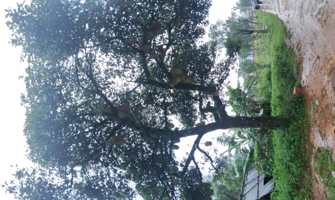
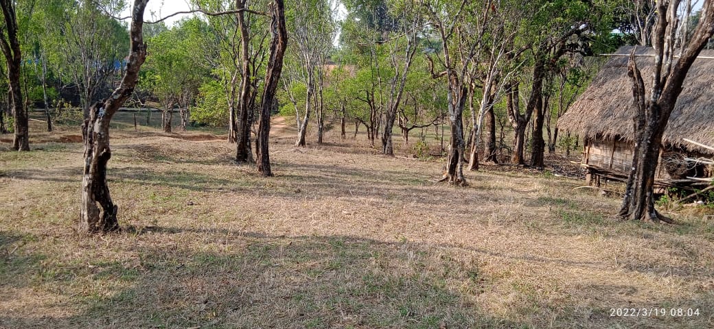
Fig: Nongummer village
VILLAGE SOCIAL PROFILE:
Nongummer village has a total number of 95 households, having a total population of 600 villagers. People in this village mainly depend on agriculture and its allied activities for their livelihood. There are teachers, businessmen and some others are engaged with government services.
Village Accessibility:
In order to reach Nongummer village one must travel through road with local taxis from the Mawkyrwat- Wahkaji-Nongummer. road.
Literacy Rate:
Literacy rate in Nongummer village is 63%. 275 out of total 433 population is educated here. Among males the literacy rate is 60% as 136 males out of total 226 are literate while female literacy rate is 67% as 139 out of total 207 females are literate in this Village.
The dark part is that illiteracy rate of Nongummer village is 36%. Here 158 out of total 433 people are illiterate. Male illiteracy rate here is 39% as 90 males out of total 226 are illiterate. Among the females the illiteracy rate is 32% and 68 out of total 207 females are illiterate in this village.
Population:
The total population of Nongummer village is 600 people and this has seen an increased over the years as of the recent survey. Out of this, 295 are male and the female count is 305.This village has 136 children belonging to the group 0-4years and 138 children are above the age of 5-14 years. About 143 total numbers of people belong to the age group of 15-30 years and 94 people are above the age of 30-60 years and 89 people belong to the age group above 60 years, thus this indicates that the majority of the population of Nongummer village comprise of the young and healthy people.
| Age Group | Male | Female | Total |
|---|---|---|---|
| 0-4years | 65 | 71 | 136 |
| 5-14years | 70 | 68 | 138 |
| 15-30years | 78 | 65 | 143 |
| 30-60years | 44 | 50 | 94 |
| Above 60years | 38 | 51 | 89 |
| Total | 295 | 305 | 600 |
Occupations:
The people of Nongummer village rely mainly on agriculture and forest produce for their livelihood. Out of 95 households within the village, 83 households are farmers, 5 household are teachers, 3 households are in government services and there is 1 ASHA and 1 ANGANWADI in the village.
V. Organisation within the Village:
There are 10 Self Help Groups (SHGs) under NRLM in Nongummer village under one Village Organisation. Presence of a committee relating to Water and Sanitation within the village. There are also 5 VEC & traditional institutions within Nongummer village.
VI. Fuel Type:
The person of Nongummer village mainly uses wood as a fuel. About 180 households depend on wood gathered from the forest for their daily requirement.
| Type of Fuel | Total No of HH | Qty (Kgs/HH) | Total |
|---|---|---|---|
| Wood | 95 | 9000kg 3Stacks per year | 837000kg |
| Charcoal | NA | NA | NA |
| LPG | NA | NA | NA |
VII. Drinking Water:
The people of Nongummer have access to drinking water mainly from the springs within the village. Government water supply lines are also available in this village. But over the years there has been a scarcity of water supply in this village due to less water discharge from the spring’s source and due to the increase in human population and their daily requirements. There are Spring Chamber within the village that they got to implement from the project CLLMP.
VIII. Cultivable Land Cover:
The type of soil in Nongummer village is Loamy soil. People practise bun cultivation and shifting cultivation in their own private lands. The main crops of Nongummer village are Paddy, Maize, Potato, Ginger, Sweet Potato, Mustard, Beans and Yam. They also plant Bay leaf, Broomsticks, Jackfruit, Mango and other cash crops.
IX. Forest Cover:
The total forest cover under Nongummer village is 1801.76 ha. Most of the forest cover are on private land and the quality of the forest is moderate. People use the forest products mainly for fuelwood, timber as medicines, aromatic plants and for other purposes. Some of the private forest within the village are Miangtymmen, Mawthar, Konlongduh, Khlewkhedek, Tyrieng, Kyntur. There is no Community Forest. Agriculture land with the area are; Khlewkhedek, Nongrimtod, Poinlang, Umtynlang, Jrimait, Lawmenop, Thyllei, Pyiur, Wahjwet, Wahlew. Horticulture land within the area are; Khlewkhedek, Nongrimtod, Poinlang, Umtynlang, Jrimait, Lawmenop, Thyllei, Pyiur, Wahjwet, Wahlew.
X. Forest Species:
Some of the indigenous tree species found in this village are Diengjri, diengsoh, diengtanglung, diengngan, dienglieng, diengsohot, diengmet. There are some plant species used by the people of the community for medicinal purposes like Diengsohniamtra, sohmrit, Sohphnat (Sohphan), diengsohpieng, dieng kait, ‘la tyrpad. The forest is home to many faunas and flora like wild birds, clouded leopard, tiger and rabbits.
XI. Water Bodies:
Total area of water bodies in Nongummer is 107.90 ha. Lots of springs within the village which people use mainly for drinking purpose. Some of the streams within the village which are all perennial and are mainly use for washing, irrigation and fisheries. There are six rivers within the geographical area of Nongummer and these are Wahrukhon, wahpoinlang, wahkynshi, wahtyllongs, wahumsohiong, wahphodshrieh.
XII. Areas Affected:
Approximately about 140.26 ha of forest land have been degraded over the years due to soil erosion, forest fires, excessive felling of trees which have led to the loss of productivity of the land and the loss of the saplings and other natural resources.
CLLMP ACTIVITIES:
1. Ground Truthing: The CLLMP officials met with Mr. Amos K. Bani, headman of Nongrynniangng village, Mr. Shadrak K. Bani the village Secretary and other village representatives for field assessment. Mr. Amos, provided the CLLMP Team with important information regarding the current scenario of the landscape and the natural resource management under his headmanship.
Case Findings:
Most of the household falls under the BPL category.
They have an actively performing VEC in the village.
The land within the village falls under the Hima Nongstoin.
The source of water supply in the village is from two sources: private and public.
There are a few patches of degraded land that has been left unused.
There is a loss of Natural Vegetation in the area.
Abundance of small streams within the village.
Forest on hill slopes are prone to forest fires.
Some of the Paddy fields in the area are without proper irrigation
2. Sensitization Programme:
The District Project Manager Mr. John K. Wanniang along with the staff held a village Level Sensitization Programme on the Community Led Landscape Management Project (CLLMP) on the 26th November 2020.The villagers actively participated in the program, voicing out their concerns and questions regarding the project making it a huge success.
Highlights of the meeting:
1. Awareness about the Community Led Landscape Management Project (CLLMP).
2. Laying the importance on the involvement of the community in making the CNRM plan and its success.
3. A brief awareness on cleanliness was conducted based on our finding during the ground truthing phase.
4. An interactive session was held to answer doubts of the villagers regarding the project.
3.Signing of EOI, VGA and Green Charter:
On the year 2020, Nongummer village signed the EOI (Expression of Interest), VGA (Village Grant Agreement) and the Green Charter after there was a uniform agreement by the people of the entire Community that the Community Led Landscape Management Project (CLLMP) be implemented at NongummerVillage.
4.Formation of the VNRMC:
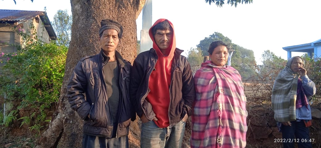
The formation of the Village Natural Resources Management Committee was done in a public meeting in the presence of the entire village and the CLLMP Staff. The people of the community chose the President, The Secretary, the Purchase Committee members and the other Executive members to formed the Nongummer VNRMC. There are 9 Executive members, 3 Village community Facilitator and 3 Purchase Committee members.
List below are the members of the VNRMC:
| Village Natural Resource Management Committee (9members committee constituted from Village Council, SHG group, Women’s group, youth, VEC) | ||||||||
|---|---|---|---|---|---|---|---|---|
| Sl No. | Name | Designation | Gender (M/F) |
Age in years | Qualification | Occupation | Community | Phone No. |
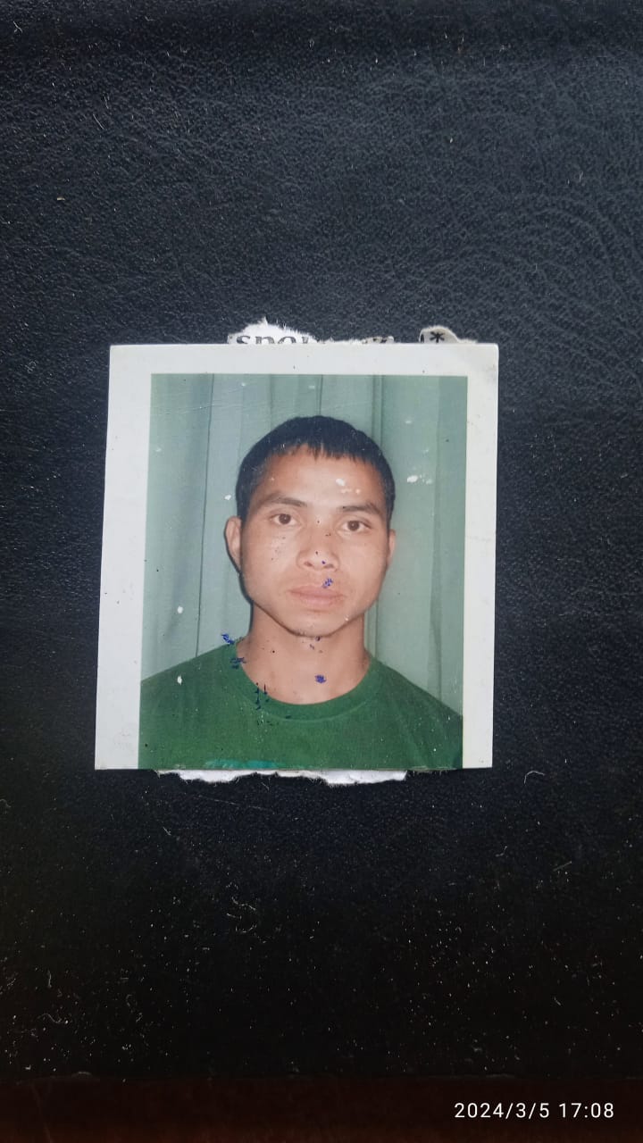
| 1. | Hamlessman Lyngdoh | Chairman | Male | 50 | X | Chairman | Khasi | 9866576078 |
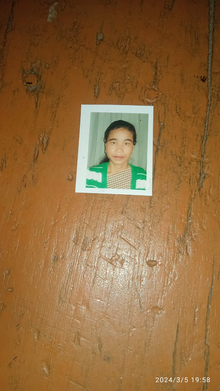
| 2. | Kiptilda K.Bani | Secretary | Female | 38 | XII | Secretary | Khasi | 9402513130 |
| 3. | Herman Lyngdoh | Finance | Male | 34 | X | Finance | Khasi | 6009574811 |
| 4. | Bloristilda K.Bani | Member | Female | 60 | IV | Member | Khasi | NA |
| 5. | RostarwelRymbai | Member | Male | 52 | VIII | Member | Khasi | NA |
| 6. | BildorisSymbei | Member | Female | 53 | VII | Member | Khasi | NA |
| 7. | Kiewdoris Symbei | Member | Female | 38 | VII | Member | Khasi | NA |
| 8. | ShalantisSymbei | Member | Male | 51 | VI | Member | Khasi | NA |
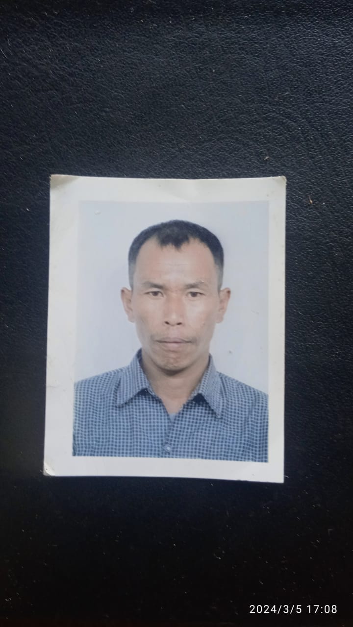
| 9. | Franklin Lyngdoh | Member | Male | 38 | BA | Member | Khasi | 8837232293 |
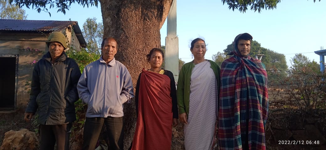
Fig: EC member of Nongummer
| Village Community Facilitators (VCF) | ||||||
|---|---|---|---|---|---|---|
| Sl no. | Name | Age | Gender | Qualification | Contact Number | Role |
| 1. | Livingstone Symbei | 35 | Male | X | 6009192292 | ME & PM |
| 2. | Donbor Mashra | 30 | Male | X | 7642008828 | Evt & GIS |
| 3. | Jaijaibel Dkhar | 27 | Female | B.A | 8787430785 | KM & SM |
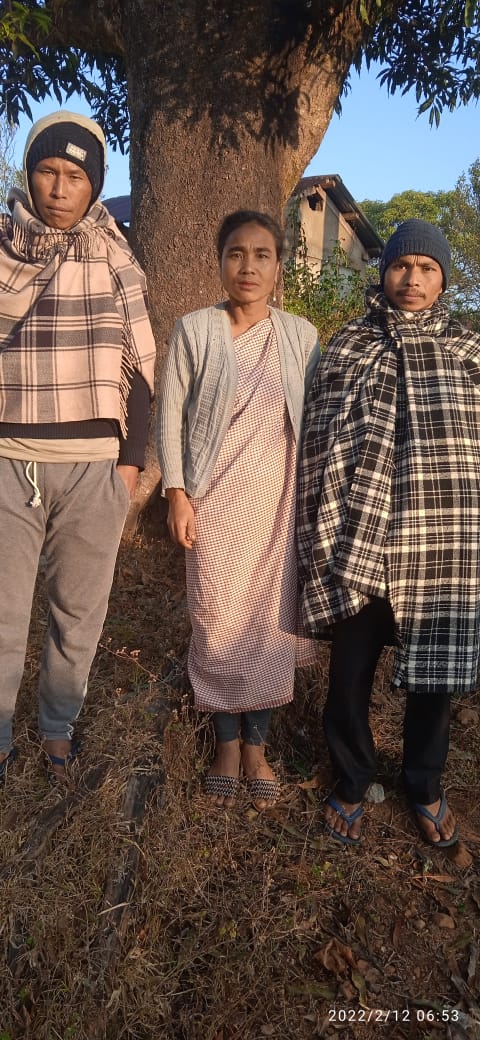
Fig:(VCF)of Nongummer
| Procurement Members | |||||
|---|---|---|---|---|---|
| Sl no. | Name | Age | Gender | Qualification | Contact Number |
| 1. | Phyrnaibor Sangriang | 50 | M | NA | NA |
| 2. | Kasparwell Symbei | 52 | M | NA | NA |
| 3. | Salam veronica K.Bani | 36 | F | NA | NA |
Fig; Procurement Member
5. Opening of Bank Account:
The opening of the bank account was done after the signing of the EOI (Expression of Interest), the VGA (Village Grant Agreement) and the signing of the Green Charter. The Accountant of CLLMP South West Khasi Hills trained the Purchasing and Procurement Committee of Nongummer village on matters relating to Accounts and Book Keeping and on the:
Principles of Community Procurement
Benefits of Community Procurement
Important aspects undertaken by Community Procurement.
Procurement Process/Steps
Function of Purchase Committee
Important Procurement records to be maintained
Financial limits and methods
Maintaining of Books of Accounts to the Book Keeper.
6. Participatory Rural Appraisal Exercise:
The PRA exercise aims to incorporate the knowledge and opinions of the community in the planning and management of development projects and programmes.
The District Project Manager gave the introduction and spoke about the different activities that the participants had to take part in the programme.
The Assistant Manager of Environment Management, spoke about the different CNRM plans and the different types of intervention. A group of participants interacted and helped in the collection of data based on the environmental template. With the help of this group, different sites of interventions was identified, analysed and evaluated in order to prioritize the areas that needed the natural resources management.
The Assistant Manager, Social Management, gathered the remaining group of participants to gather the baseline data bases on the social template.
The main objectives of PRA exercise is:
To identify the natural, human and economic resources of the village.
To identify the village problems and prioritized them with the help of the community members.
To prepare the community natural resources management plan of the village.
Findings based on the information gathered from the participants during the PRA/CNRMP exercise:
1.The main agricultural produce is Paddy, Maize and Potato.
2.Most of the household depend on firewood as a source of fuel.
3.Drinking water is limited over a period of 3-4 months during the winter season.
4.There are two types of forest ownership: Community and Private.
5.There is one Community Forest.
6.The springs which are present in the village needs rejuvenation.
7.Training on Land productivity, Spring shed management and Community nursery is necessary for the village community.
8.There are no disputes/constraints encountered within the village community or with any neighbouring villages.
Priorities Intervention required based on the PRA Exercise:
1.Rejuvination of the Springs within the community through activities such as afforestation, treatment of catchment areas and contour trenches.
2. Afforestation, Bio-fencing and fire line control in the community forest.
3.Community Nursery for endemic trees.
4.A dug out pond for collecting rain water for.
5.Check dams for erosion control.
6.Afforestation and Roadside plantation.
7.Culturable wastelands to be brought under horticulture.
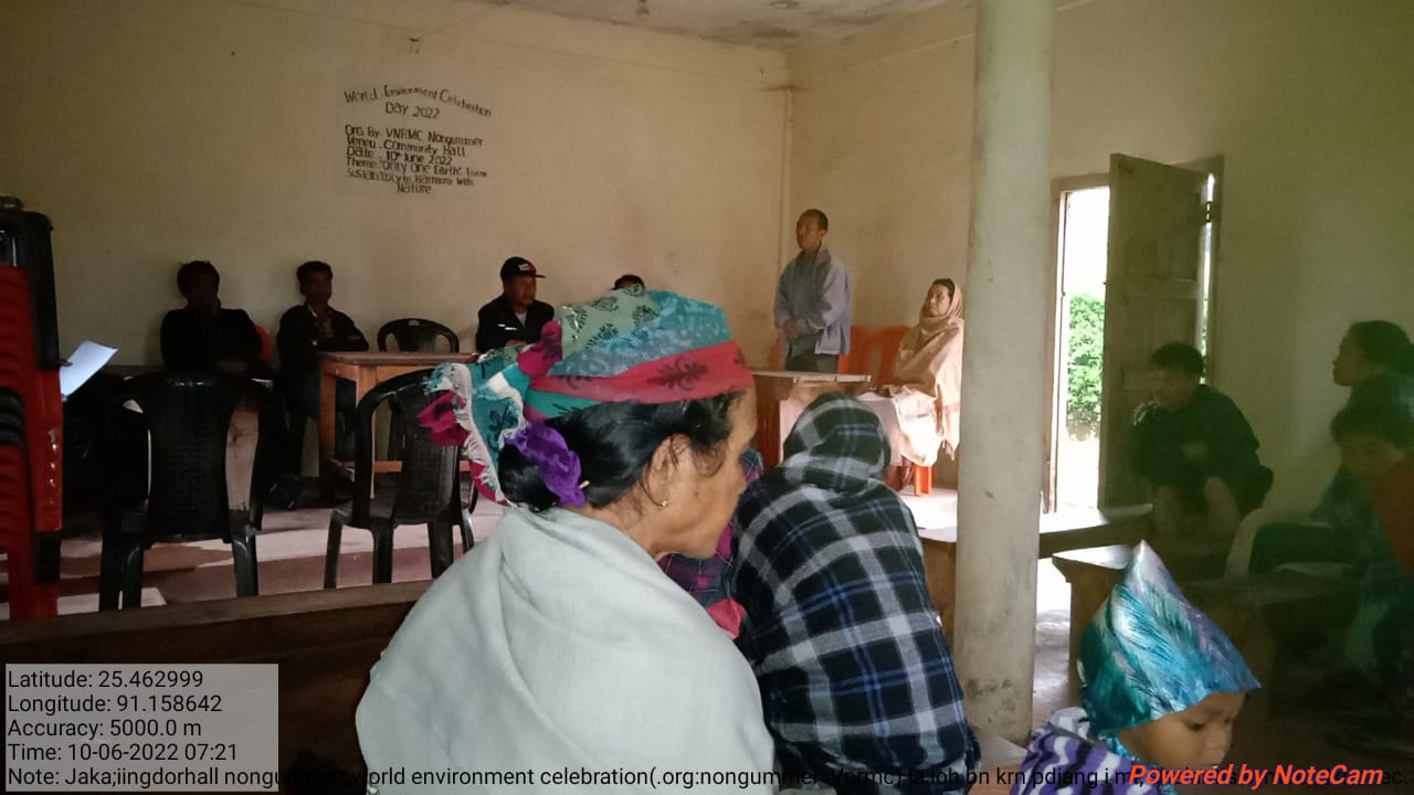
Fig: VNRMC members participating in awareness programme.
Baseline Data Survey to fill the Environment and Social Template:
During the PRA Exercise the External Expert of Social & Environment Management held a group discussion with the different groups to gather basic village information regarding number of households, demographic information, major crops and enterprises taken in the village, trends of production and productivity of major crops in the village and demographic distribution of village population.
Information related to land use category such as forest, cultivable land, water bodies, etc and the problems and challenges related to NRM were discussed.
Focussed Group Discussion on Problem Analysis:
1.Do people have sufficient access to supply of fodder, fuel wood, leaf litter?
Yes, people in the village have sufficient access to supply of fodder, fuel wood, leaf litter. They get it from the community forest and from their own private lands/forest.
2. Has access to timber improved or reduced over the years? How is access for household use and commercial use managed?
Access to Timber has reduced over the years. People have to purchase it from neighbouring village when needed.
3.Are the water bodies facing any threats?
So far, the water bodies within the village have not faced any threats.
4. Do all people in the village have access to drinking water? What are the challenges?
Yes, there is sufficient drinking water in the village except during the winter season due to less discharge of water from the spring source.
5. Are there degraded areas in the village (open/ degraded forests, mining affected, high soil erosion etc.)?
There are some minor degradations in cultivated land.
6. What has caused this degradation? Are there practices causing threats to availability and access to natural resources?
Fertility of the soil has decline over the year.
The practices that cause threat to the availability of these resources are:
Fires that take place every year
Excessive practice of Jhum Cultivation
7. What have been the changes in agricultural practices?
Previously their method of farming is Shifting Cultivation, but over the years with much awareness people have now practiced crop rotation.
8.Are there any challenges in farming?
The main challenges faced by the people of Nongummer village is that over the years they have seen a decline in the soil productivity due to soil erosion.
9. How would you consider the health situation in your village?
The nearest health care is in the district headquarter with a distance of 20Km away and is easily accessible for the community as a whole to commute to the health centre.
10.How is the situation of cleanliness, sanitation, access to toilets and waste management?
The SHG members is responsible for organizing the cleaning drive once in a month.
Sufficient toilets are available in every household but most of the constructions are poor. Some households have access to toilets from SBM (Swash Bharat Mission) scheme. The presence of VWSC in the village has also improve sanitation and cleanliness. But Waste Management is poor because people are not really aware of how to properly disposed off waste.
11.Who are the most vulnerable in the village? What can be done to improve their lives?
BPL Families. Inclusion of BPL family members during project implementation
12. What are the livelihood aspirations of the youth? Are there any avenues available?
None, except daily wages labourers.
13. Do any committees/ institutions/ rules exist to manage and monitor natural resources in the village?
The VNRMC under the CLLMP is the main committee that is now in place to manage the natural resources in the village.
14.What are some of the major issues of conflict in the village?
Nothing related to NRM.
15.Have any of the above issues been discussed in village meetings?
Yes.
16. How do people resolve disagreements and conflicts?
All disagreements and conflicts are addressed by the traditional institution of village called the Village Dorbar.
7.Village Boundary Mapping and Recourse Mapping:
The GIS personnel along with the Village Community Facilitators mapped the village boundary of NongummerVillage.
The village resource map is prepared by the people of the community. In this resource map, the local people prepare it by drawing it on chart paper. Resources such as agricultural lands, wells, wastelands, cattle population, playgrounds, ICDS, churches, community halls, etc were mapped.
Findings Based on the Resource Map of Nongummer Village:
1. Main agriculture produce is Maize, Potato, Sweet potato and Paddy.
2. There are two type of Forest ownership: Private owned and clan forest.
3. There are six rivers present: Wahrukhon, Wahpoinlang, Wahkynshi, Wahtyllongs, Wahumsohiong, Wahphodshrieh.
5. There is 1 Community Hall in the village.
7.There is 1 Football playground.
8. Presence of Integrated Child Development Services (ICDS) through Anganwadi Centre (AWC).
9. There is one primary school and one secondary school within Nongummer village.
8.GIS Activities:
| Sl. No. | Parameters | Village Information |
|---|---|---|
| 1 | GPS Coordinates: | |
| i | Latitude | 25.41499 |
| ii | Longitude | 91.160647 |
| iii | Elevation Reading (MSL) | 1017 m |
| 2 | Village Geographical Area (Ha) | 3279.68 ha |
| i | Total Forest Area (including community, Clan, Pvt Forest) | 1801.76 ha |
| ii | Total Area of Water Bodies | 107.90 ha |
| iii | Total Area under Agro-Horticulture | 00 ha |
| iv | Total Degraded land area (Ha) | 140.26 ha |
| 3 | Average Annual Rainfall | 12000mm |
| 4 | Soil Type | Loamy soil |
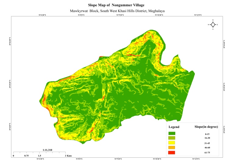
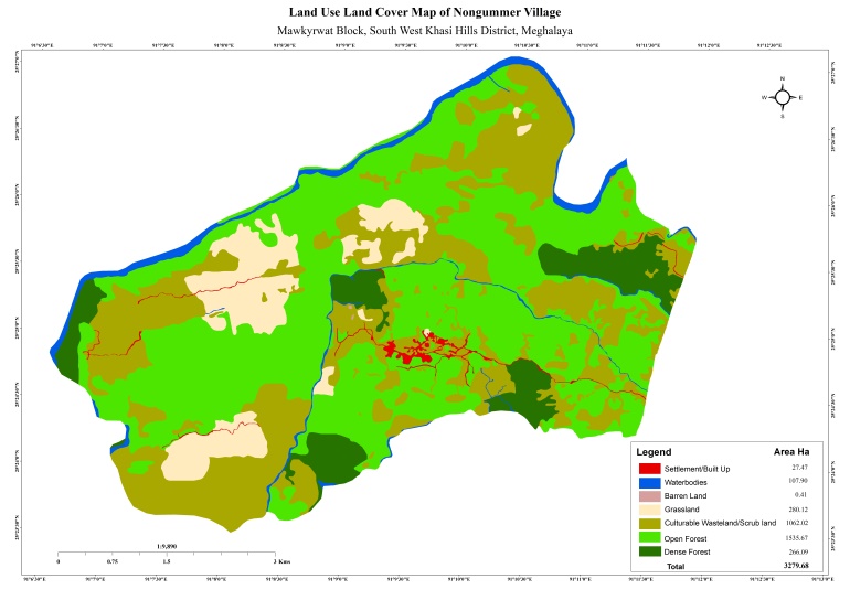
Fig:Slope Map and LULC Map of Nongummer
9. The Proposed list of Interventions:
|
Name of Proposed Interventions | Site |
|
Nos of HHs expected to Benefit | Priority (High/ Medium/ Low) | ||
|---|---|---|---|---|---|---|---|
|
|
|
|||||
| 1 | Spring Chamber | Dongrisim |
|
|
|
15 |
|
| 2 | Spring Chamber | Lawsynri |
|
|
|
13 |
|
| 3 | Nongrimtod | Nongrimtod |
|
|
|
2 |
|
| 4 | Half Moon Terraces | KhyloKhatek |
|
|
|
3 |
|
| 5 | Agro-Horticulture | Nongrimtod |
|
|
|
1 |
|
| 6 | Agro-Forestry | Umteinlang |
|
|
|
5 |
|
| 7 | Agro-Forestry | Pyiur |
|
|
|
1 |
|
| 8 | Agro-Forestry | Jynrinmait |
|
|
|
2 |
|
| 9 | Agro-Horticulture | Nongmarshra |
|
|
|
8 |
|
| 10 | Agro-Forestry | Thyllei |
|
|
|
6 |
|
| 11 | Agro-Horticulture | Lawmerop |
|
|
|
6 |
|
| 12 | Agro-Horticulture | KhyloKhatek |
|
|
|
7 |
|
| 13 | Loose Boulder Bunds | Miangtymmen |
|
|
|
3 |
|
| 14 | Loose Boulder | Langshmang1 |
|
|
|
3 |
|
| 15 | Loose Boulder Bunds | Poinlang2 |
|
|
|
2 |
|
| 16 | Loose Boulder Bunds | Poinlang3 |
|
|
|
2 |
|
| 17 | Nursery Of Non-Pine Seedling |
|
|
|
95 |
|
|
| 18 | Inter-Cropping | Thylle 1 |
|
|
|
1 |
|
| 19 | Agro Horticulture | Thyllei 2 |
|
|
|
1 |
|
| 20 | Agro Horticulture | Weilongdeng |
|
|
|
1 |
|
| 21 | Inter-Cropping | Weilongdeng 1 |
|
|
|
1 |
|
| 22 | Agro-Holticulture | Mawlongkhohroh |
|
|
|
1 |
|
| 23 | Agro-Holticulture | Lawmerop |
|
|
|
1 |
|
| 24 | Agro-Holticulture | Khnokdek |
|
|
|
1 |
|
| 25 | Agro-Holticulture | Nongmarshra |
|
|
|
1 |
|
| 26 | Agro-Holticulture | Khenmot |
|
|
|
1 |
|
| 27 | Inter-Cropping | Diangwang |
|
|
|
1 |
|
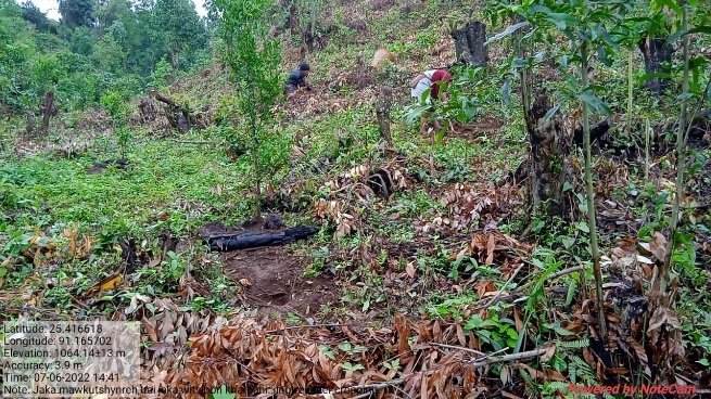
| 28 | Inter-Cropping | Mawkutshynreh |
|
|
|
1 |
|
| 29 | Inter-Cropping | Rang Khla |
|
|
|
1 |
|
| 30 | Inter-Cropping | Miangtymmen |
|
|
|
1 |
|
| 31 | Inter-Cropping | Mawstuphniaw |
|
|
|
1 |
|
| 32 | Agro-Holticulture | Langshangmang 2 |
|
|
|
1 |
|
| 33 | Agro-Holticulture | Langshangmang 3 |
|
|
|
1 |
|
| 34 | Agro-Holticulture | Langshangmang 4 |
|
|
|
1 |
|
| 35 | Agro-Holticulture | Warslo 1 |
|
|
|
1 |
|
| 36 | Agro-Holticulture | Warslo 2 |
|
|
|
1 |
|
| 37 | Agro-Holticulture | Warslo 3 |
|
|
|
1 |
|
| 38 | Agro-Holticulture | Mawmuit 1 |
|
|
|
1 |
|
| 39 | Agro-Holticulture | Mawmuit 2 |
|
|
|
1 |
|
| 40 | Agro-Holticulture | Mawmuit 3 |
|
|
|
1 |
|
| 41 | Inter-Cropping | Poinlang 1 |
|
|
|
1 |
|
| 42 | Inter-Cropping | Poinlang 2 |
|
|
|
1 |
|
| 43 | Inter-Cropping | Poinlang 3 |
|
|
|
1 |
|
| 44 | Inter-Cropping | Poinlang 4 |
|
|
|
1 |
|
| 45 | Horticulture | Langshmang 1 |
|
|
|
8 |
|
| 46 | Inter Cropping | Langshangmang 1 |
|
|
|
1 |
|
| 47 | Horticulture | Nongrimtod |
|
|
|
4 |
|
| 48 | Spring Chamber | Umtongbah |
|
|
|
95 |
|
Project Implementation:
| 1. | Type Of Intervention | Site Name | GPS Co-ordinates | Amount Sanctioned | Work Status | |
|---|---|---|---|---|---|---|
| Construction of Spring Chamber | Dongrism | 25.415304 | 91.166205 | 43340 | Completed | |
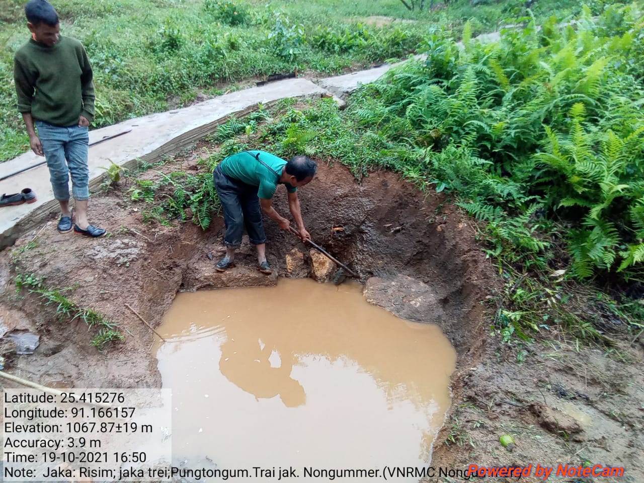
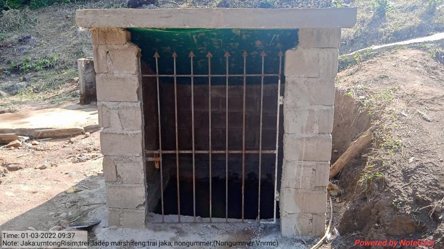
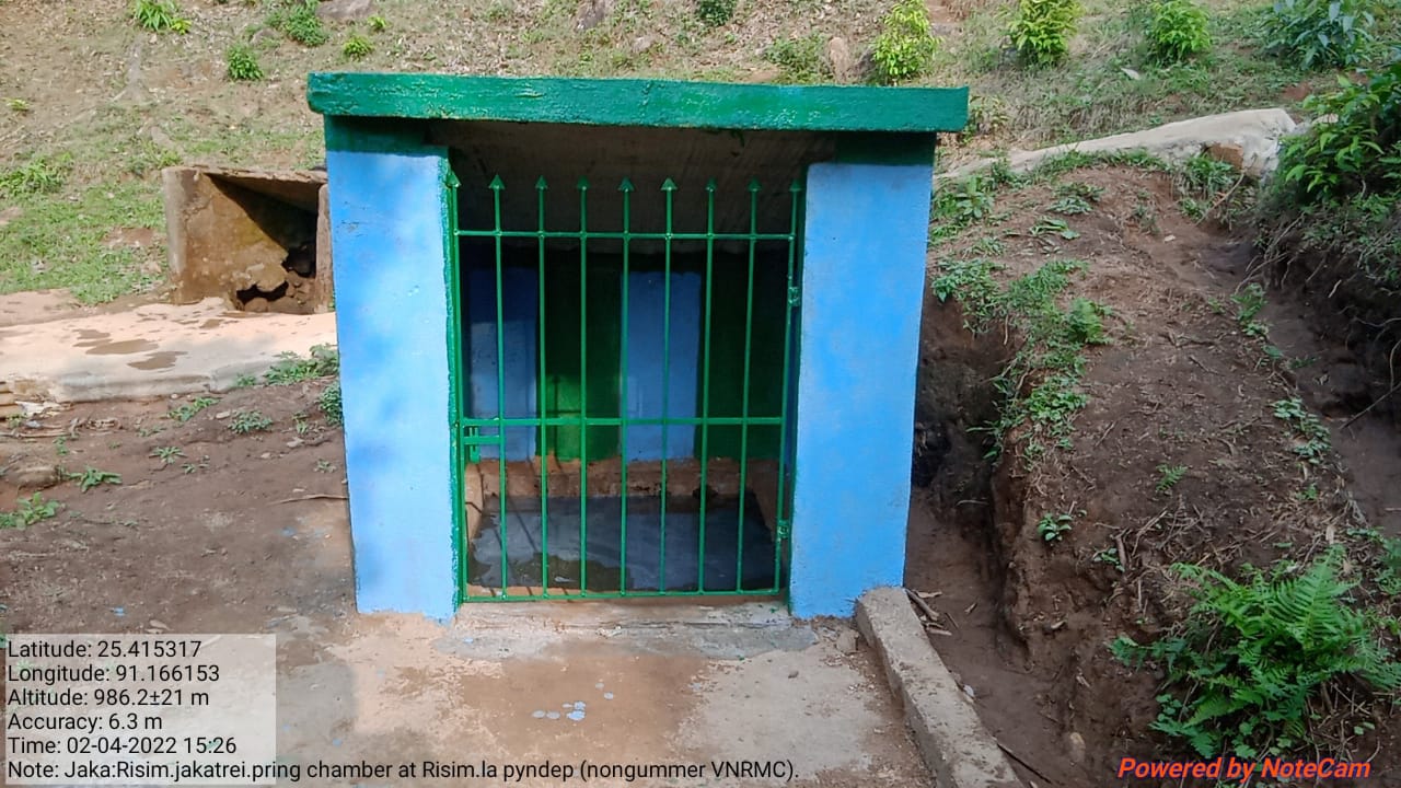
Fig:Spring Chamber at Dongrism
| 2. | Type Of Intervention | Site Name | GPS Co-ordinates | Amount Sanctioned | Work Status | |
|---|---|---|---|---|---|---|
| Spring Chamber | Lawsynri | 25.414996 | 91.15772 | 44500 | Completed | |
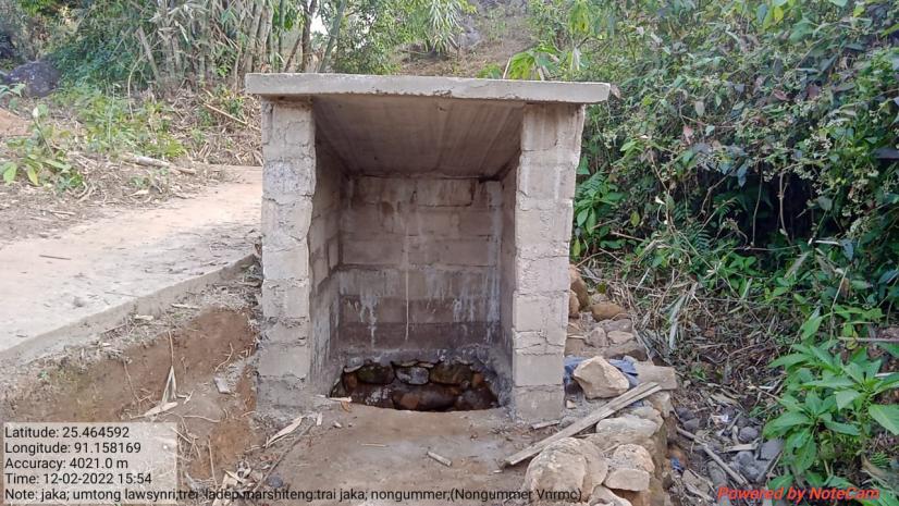
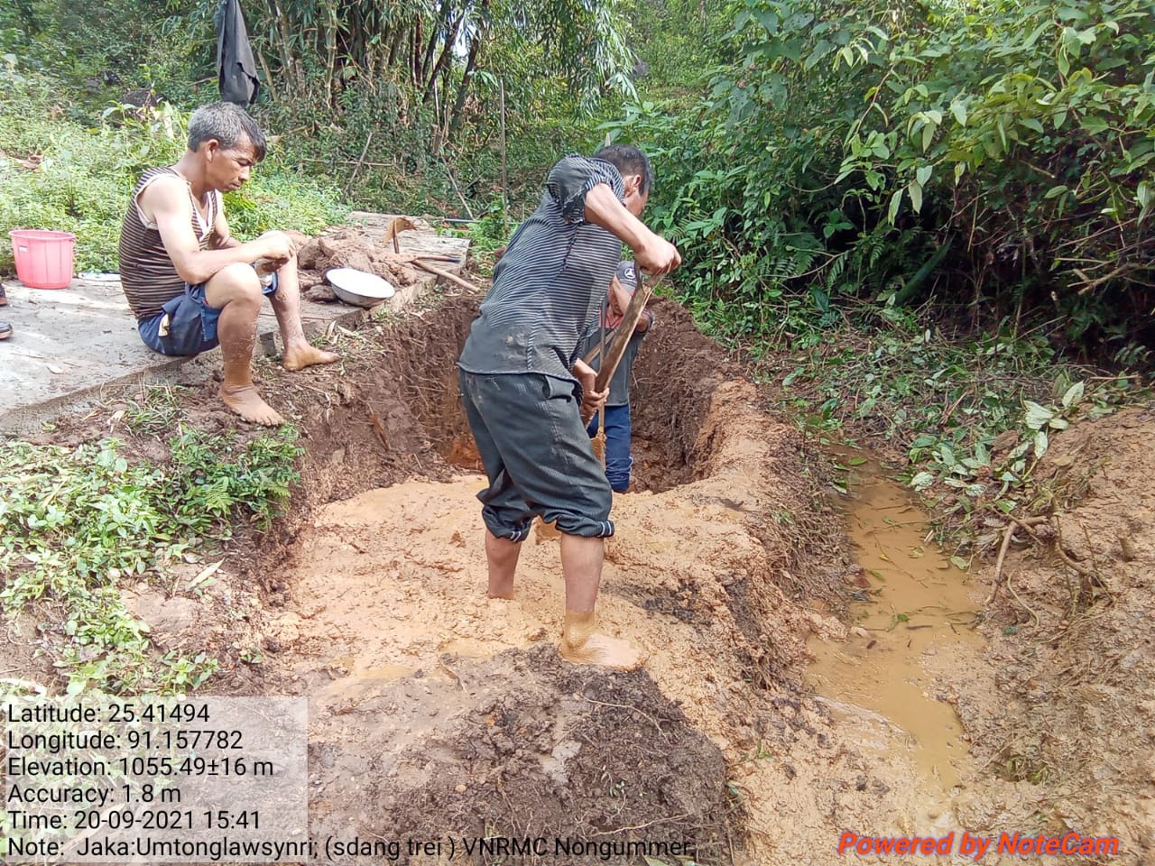
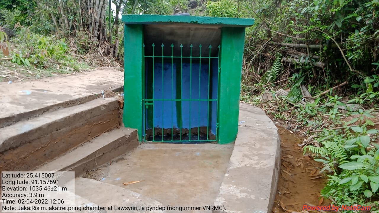
Fig:SpringChamber at Lawsynri
| 3. | Type Of Intervention | Site Name | GPS Co-ordinates | Amount Sanctioned | Work Status | |
|---|---|---|---|---|---|---|
| HALF MOON TERRACES | NONGRIMTOD | 25.417645 | 91.163858 | 15150 | Completed | |
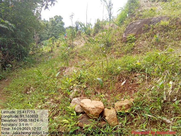
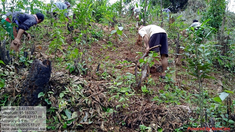

Fig: Half Moon Terrace at Nongrimtod
| 4. | Type Of Intervention | Site Name | GPS Co-ordinates | Amount Sanctioned | Work Status | |
|---|---|---|---|---|---|---|
| HALF MOON TERRACES | AT KHYLO KHATEK | 25.416816 | 91.161891 | 65700 | Completed | |
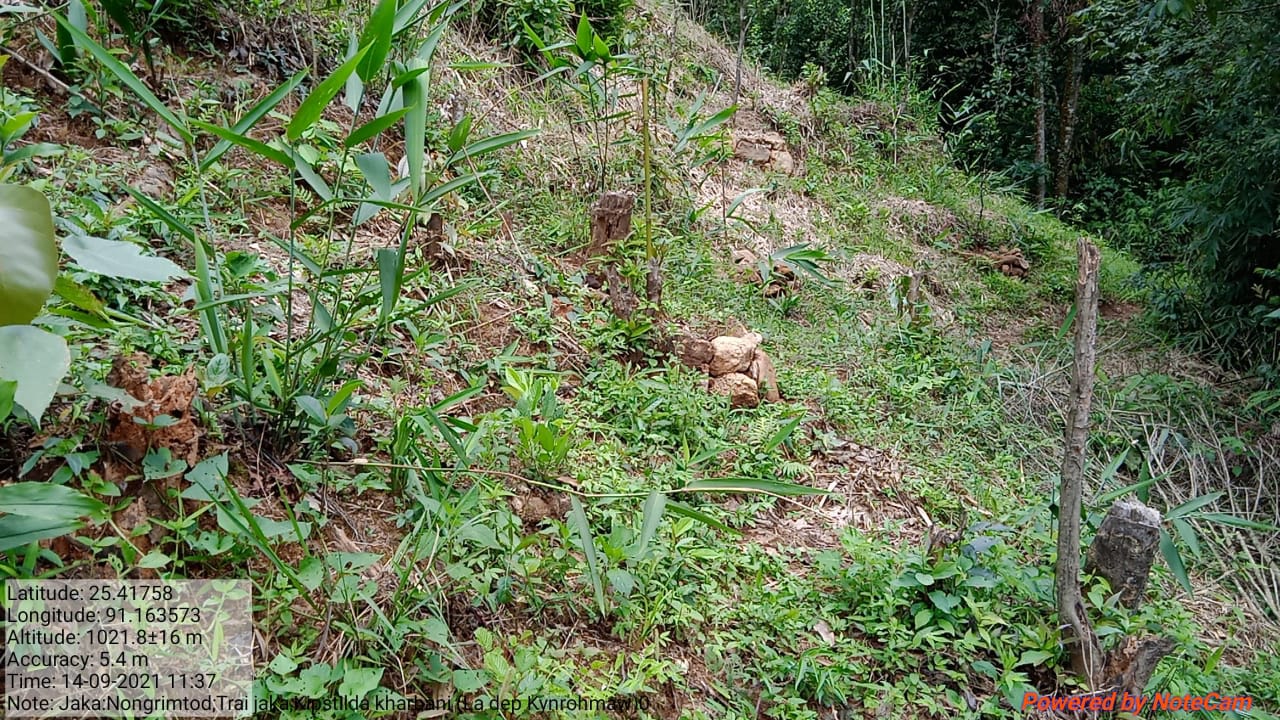
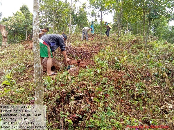
Fig: Half Moon Terrace at Khylo Khatek
| 5. | Type Of Intervention | Site Name | GPS Co-ordinates | Amount Sanctioned | Work Status | |
|---|---|---|---|---|---|---|
| AGRO-HORTICULTURE | NONGRIMTOD | 25.417547 | 91.163539 | 25250 | Completed | |
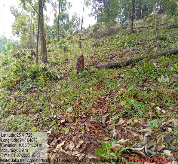
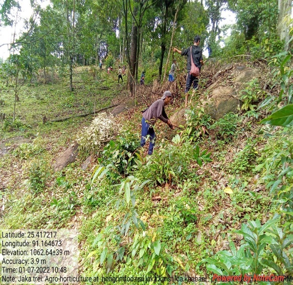
Fig: Agro-Horticulture at Nongrimtod
| 6. | Type Of Intervention | Site Name | GPS Co-ordinates | Amount Sanctioned | Work Status | |
|---|---|---|---|---|---|---|
| AGRO-FORESTRY | UMTEINLANG | 25.42184 | 91.136604 | 97400 | Completed | |
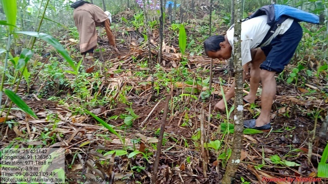
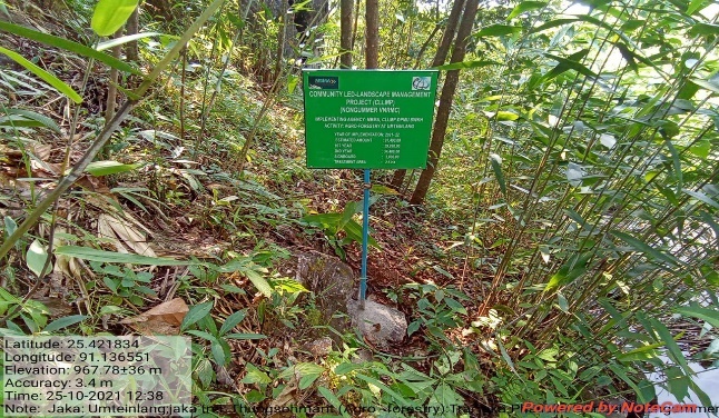
Fig: Agro-Forestry at Umteilang
| 7. | Type Of Intervention | Site Name | GPS Co-ordinates | Amount Sanctioned | Work Status | |
|---|---|---|---|---|---|---|
| AGRO-FORESTRY | AT PYIUR | 25.429548 | 91.148615 | 97400 | Completed | |
Fig: Agro-Forestry at Pyiur
| 8. | Type Of Intervention | Site Name | GPS Co-ordinates | Amount Sanctioned | Work Status | |
|---|---|---|---|---|---|---|
| AGRO-FORESTRY | AT JYNRINMAIT | 25.428069 | 91.140737 | 97400 | Completed | |
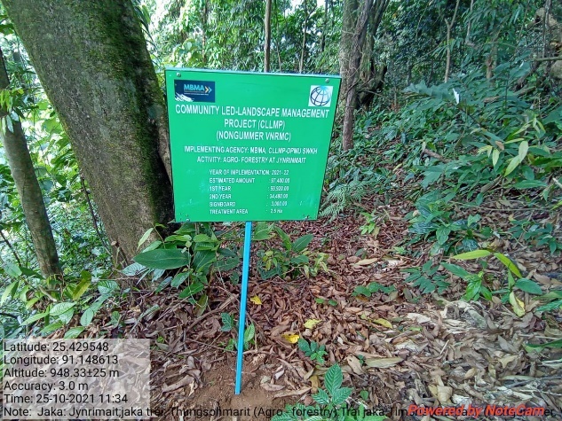
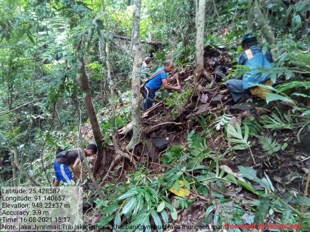
Fig: Agro-Forestry at Jynrinmait
| 9. | Type Of Intervention | Site Name | GPS Co-ordinates | Amount Sanctioned | Work Status | |
|---|---|---|---|---|---|---|
| AGRO-HORTICULTURE | NONGMARSHRA | 25.415552 | 91.139099 | 97400 | Completed | |
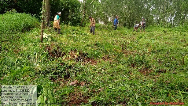
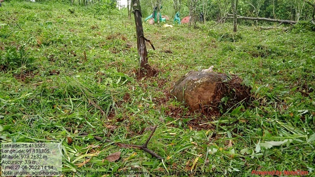
Fig: Agro-Horticulture at Nongmarshra
| 10. | Type Of Intervention | Site Name | GPS Co-ordinates | Amount Sanctioned | Work Status | |
|---|---|---|---|---|---|---|
| AGRO-FORESTRY | AT THYLLEI | 25.408798 | 91.160524 | 47500 | Completed | |

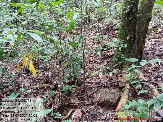
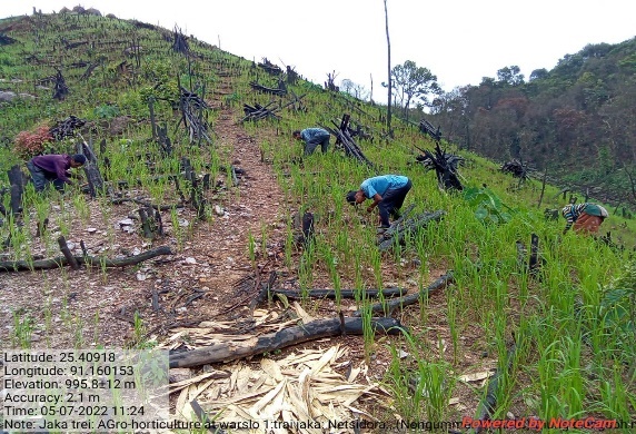
Fig: Agro-Forestry at Thyllei
| 11. | Type Of Intervention | Site Name | GPS Co-ordinates | Amount Sanctioned | Work Status | |
|---|---|---|---|---|---|---|
| AGRO-HORTICULTURE | AT LAWMEROP | 25.413035 | 91.170645 | 47500 | Completed | |
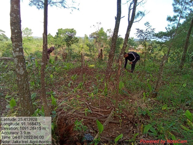
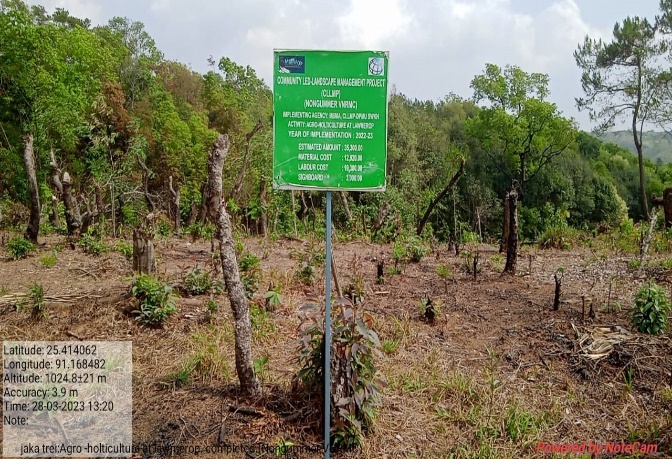
Fig: Agro-Horticulture at Lawmerop
| 12. | Type Of Intervention | Site Name | GPS Co-ordinates | Amount Sanctioned | Work Status | |
|---|---|---|---|---|---|---|
| AGRO-HORTICULTURE | AT KHYLO KHATEK | 25.41742 | 91.162231 | 61220 | Completed | |

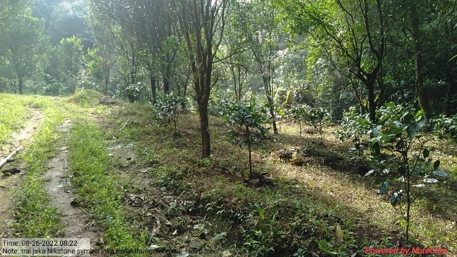
Fig: Agro-Horticulture at Khylo Khatek
| 13. | Type Of Intervention | Site Name | GPS Co-ordinates | Amount Sanctioned | Work Status | |
|---|---|---|---|---|---|---|
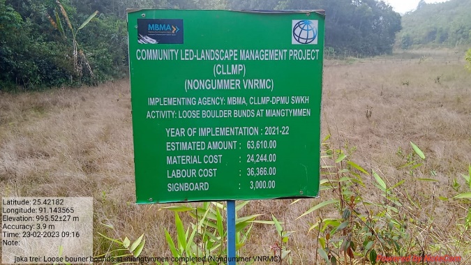
| Loose Boulder Bunds | Miangtymmen | 25.421452 | 91.143151 | 63610 | Completed | |
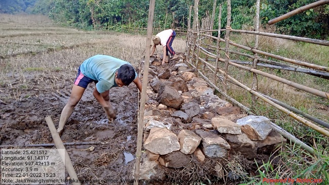 Fig: Loose Boulder Bund at
Miangtymmen
Fig: Loose Boulder Bund at
Miangtymmen
| 14. | Type Of Intervention | Site Name | GPS Co-ordinates | Amount Sanctioned | Work Status | |
|---|---|---|---|---|---|---|
| Loose Boulder Bunds | Langshmang1 | 25.421458 | 91.157505 | 42540 | Completed | |
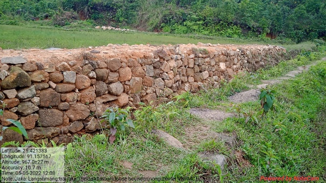
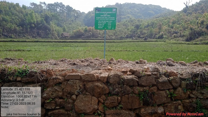
Fig: Loose Boulder Bund at Langshmang 1
| 15. | Type Of Intervention | Site Name | GPS Co-ordinates | Amount Sanctioned | Work Status | |
|---|---|---|---|---|---|---|
| Loose Boulder Bunds | Poinlang 2 | 25.401437 | 91.157465 | 45520 | Completed | |
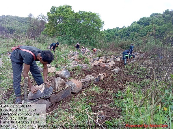
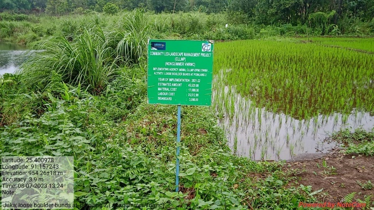
Fig: Loose Boulder Bunds at Poinlang 2
| 16. | Type Of Intervention | Site Name | GPS Co-ordinates | Amount Sanctioned | Work Status | |
|---|---|---|---|---|---|---|
| Loose Boulder Bunds | Poinlang 3 | 25.401116 | 91.157528 | 45520 | Completed | |
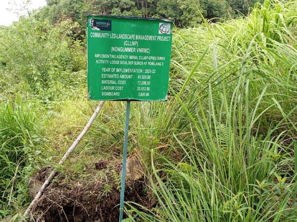
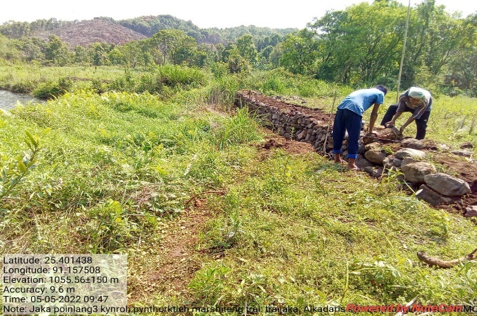
Fig: Loose Boulder Bunds at Poinlang 3
| 17. | Type Of Intervention | Site Name | GPS Co-ordinates | Amount Sanctioned | Work Status | |
|---|---|---|---|---|---|---|
| Nursery of Non-Pine Seedling | Nongummer | 25.416465 | 91.165048 | 164950 | Completed | |
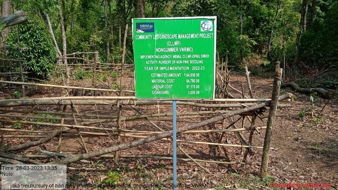
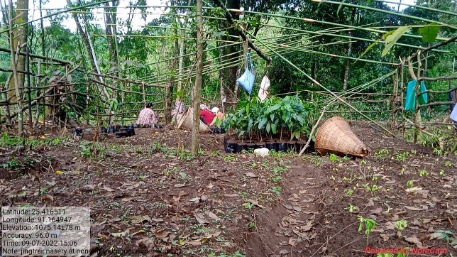
Fig: Nursery of Non-Pine Seedling at Nongummer
| 18. | Type Of Intervention | Site Name | GPS Co-ordinates | Amount Sanctioned | Work Status | |
|---|---|---|---|---|---|---|
| Inter-Cropping | Thylle 1 | 25.408758 | 91.162153 | 54300 | Completed | |
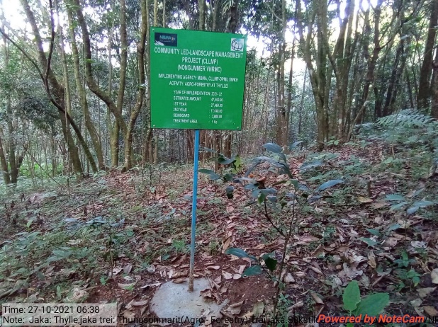

Fig: Inter-Cropping at Thylle 1
| 19. | Type Of Intervention | Site Name | GPS Co-ordinates | Amount Sanctioned | Work Status | |
|---|---|---|---|---|---|---|
| Agro Horticulture | Thylle 2 | 25.40883 | 91.16074 | 18650 | Completed | |
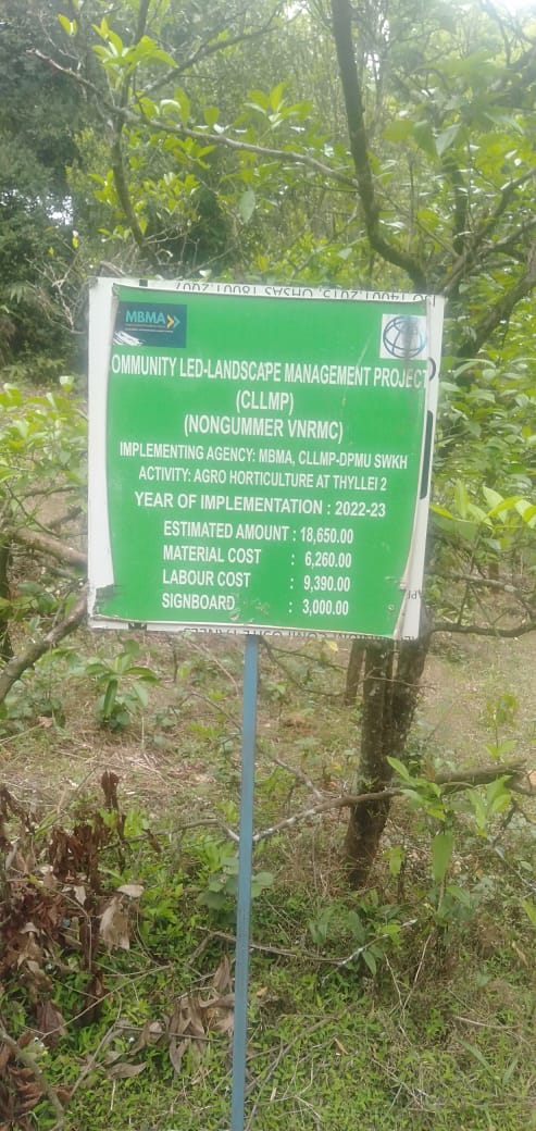
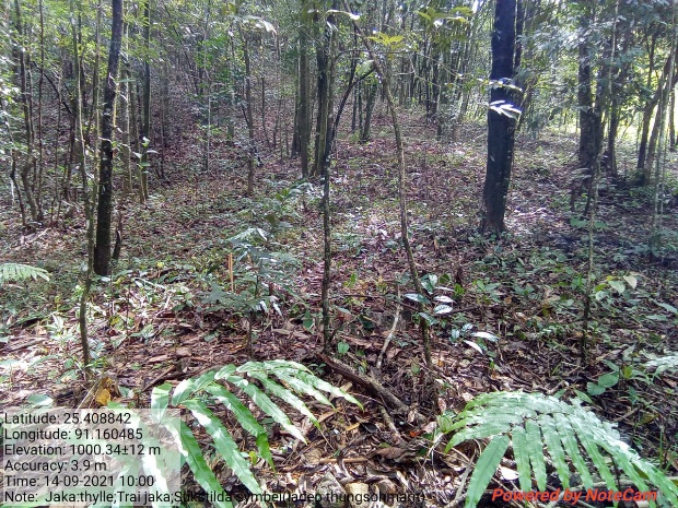
Fig: Agro-Horticulture at Thylle 2
| 20. | Type Of Intervention | Site Name | GPS Co-ordinates | Amount Sanctioned | Work Status | |
|---|---|---|---|---|---|---|
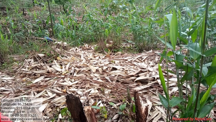
| Agro Horticulture | Weilongdeng | 25.396608 | 91.15386 | 25010 | Completed | |
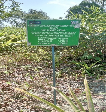
| 21. | Type Of Intervention | Site Name | GPS Co-ordinates | Amount Sanctioned | Work Status | |
|---|---|---|---|---|---|---|
| Inter-Cropping | Weilongdeng 1 | 25.396538 | 91.154953 | 39955 | Completed | |
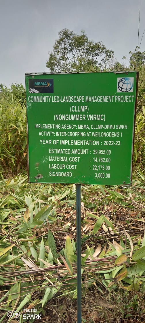 Fig: Agro
Horticulture at Weilongden
Fig: Agro
Horticulture at Weilongden
Fig: Inter-Cropping at Weilongdeng
| 22. | Type Of Intervention | Site Name | GPS Co-ordinates | Amount Sanctioned | Work Status | |
|---|---|---|---|---|---|---|
| Agro-Holticulture | Mawlong Khohroh | 25.41483 | 91.154769 | 25010 | Completed | |
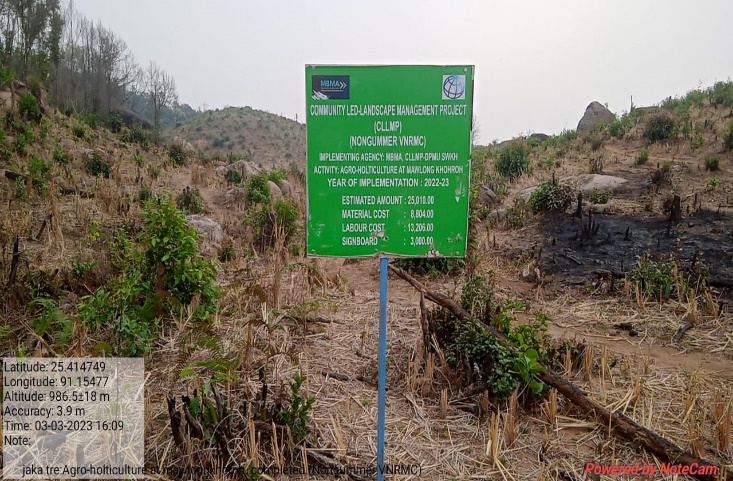
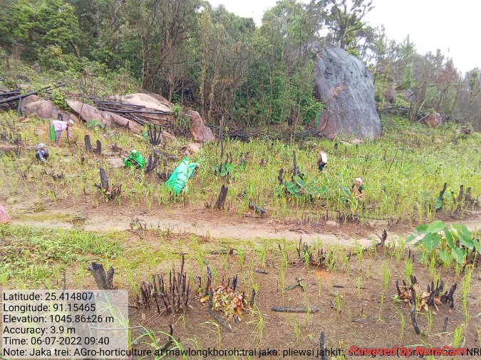
Fig: Agro-Horyiculture at Mowlong Khohroh
| 23. | Type Of Intervention | Site Name | GPS Co-ordinates | Amount Sanctioned | Work Status | |
|---|---|---|---|---|---|---|
| Agro-Holticulture | Lawmerop | 25.41328 | 91.168475 | 35300 | Completed | |

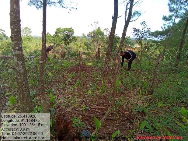
Fig: Agro-Horticulture at Lawmerop
| 24. | Type Of Intervention | Site Name | GPS Co-ordinates | Amount Sanctioned | Work Status | |
|---|---|---|---|---|---|---|
| Agro-Holticulture | Khnokdek | 25.417221 | 91.160339 | 18650 | Completed | |
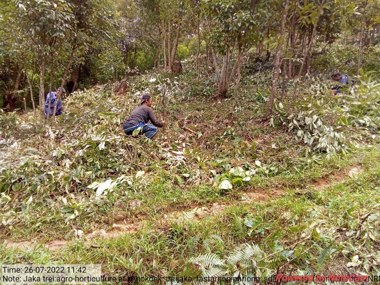
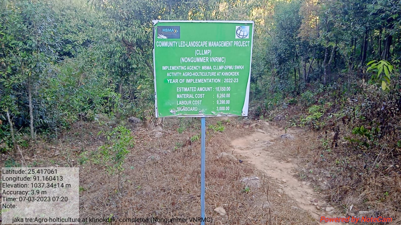
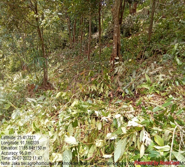
Fig: Agro-Horticulture at Khnokdek
| 25. | Type Of Intervention | Site Name | GPS Co-ordinates | Amount Sanctioned | Work Status | |
|---|---|---|---|---|---|---|
| Agro-Holticulture | Nongmarshra | 25.41291 | 91.138892 | 25010 | Completed | |
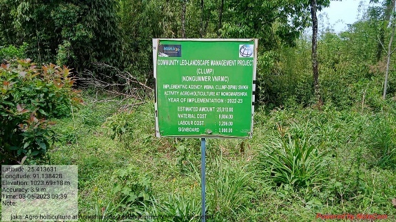
Fig: Agro-Horticulture at Nongmarshra
| 26. | Type Of Intervention | Site Name | GPS Co-ordinates | Amount Sanctioned | Work Status | |
|---|---|---|---|---|---|---|
| Agro-Holticulture | Khenmot | 25.417537 | 91.157074 | 18650 | Completed | |
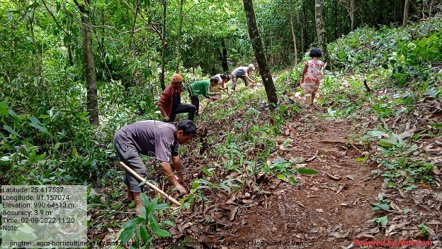
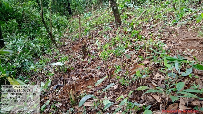
Fig: Agro-Horticultrure at Khenmot
| 27. | Type Of Intervention | Site Name | GPS Co-ordinates | Amount Sanctioned | Work Status | |
|---|---|---|---|---|---|---|
| Inter-Cropping | Diangwang | 25.42588 | 91.165304 | 34330 | Completed | |
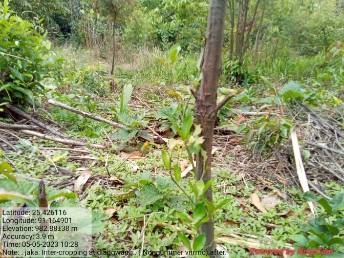
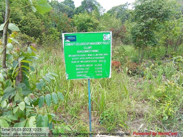
Fig: Inter-Cropping at Diangwang
| 28. | Type Of Intervention | Site Name | GPS Co-ordinates | Amount Sanctioned | Work Status | |
|---|---|---|---|---|---|---|
| Inter-Cropping | Mawkut Shynreh | 25.416285 | 91.165304 | 25010 | Completed | |
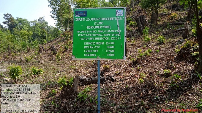
Fig: Inter-Cropping at Mawkut Shynreh
| 29. | Type Of Intervention | Site Name | GPS Co-ordinates | Amount Sanctioned | Work Status | |
|---|---|---|---|---|---|---|
| Inter-Cropping at | Rang Khla | 25.406232 | 91.151625 | 25010 | Completed | |
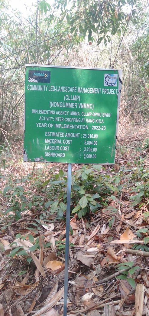
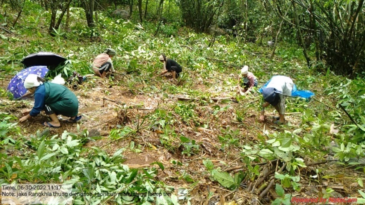
Fig: Inter-Cropping at Rang Khla
| 30. | Type Of Intervention | Site Name | GPS Co-ordinates | Amount Sanctioned | Work Status | |
|---|---|---|---|---|---|---|
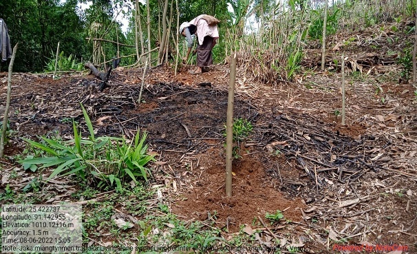
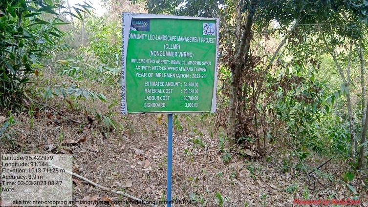
| Inter-Cropping | Miang Tymmen | 25.422842 | 91.143714 | 54300 | Completed | |
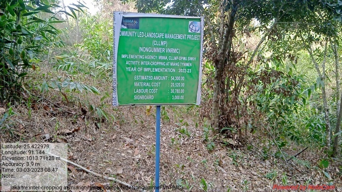
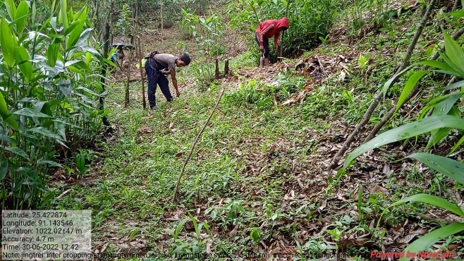
Fig: Inter-Cropping at Miang Tymmen
| 31. | Type Of Intervention | Site Name | GPS Co-ordinates | Amount Sanctioned | Work Status | |
|---|---|---|---|---|---|---|
| Inter-Cropping | Mawstuphniaw | 25.412669 | 91.165783 | 34330 | Completed | |
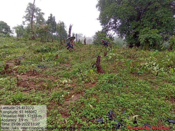
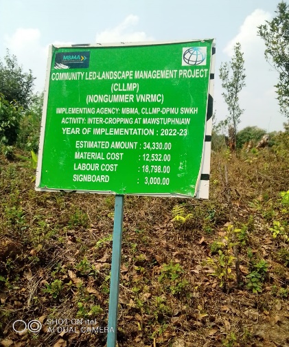
Fig: Inter-Cropping at Mawstuphniaw
| 32. | Type Of Intervention | Site Name | GPS Co-ordinates | Amount Sanctioned | Work Status | |
|---|---|---|---|---|---|---|
| Agro-Holticulture | Langshangmang 2 | 25.41876 | 91.156497 | 25010 | Completed | |
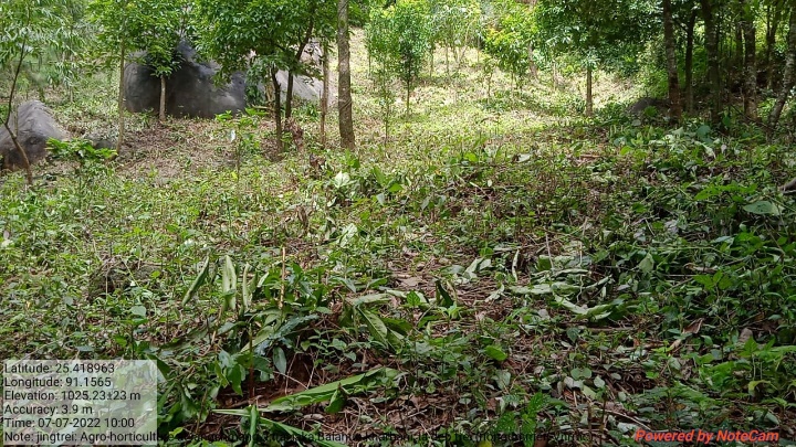
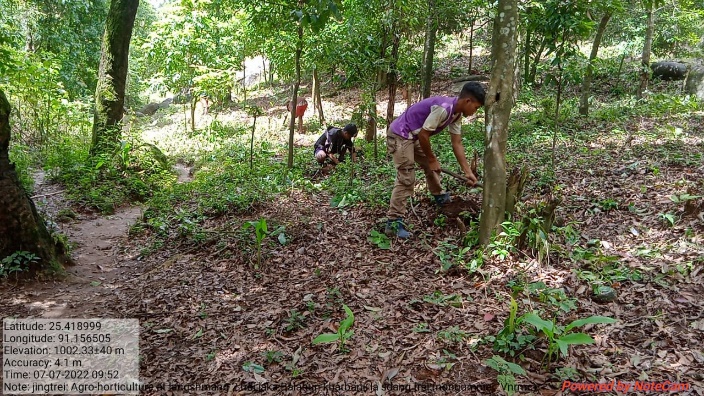
Fig: Agro-Horticulture at Langshmang 2
| 33. | Type Of Intervention | Site Name | GPS Co-ordinates | Amount Sanctioned | Work Status | |
|---|---|---|---|---|---|---|
| Agro-Holticulture | Langshangmang 3 | 25.419898 | 91.155967 | 25010 | Completed | |
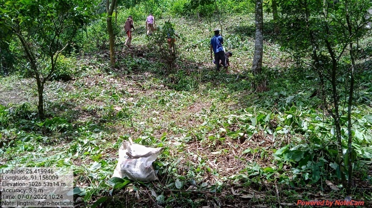
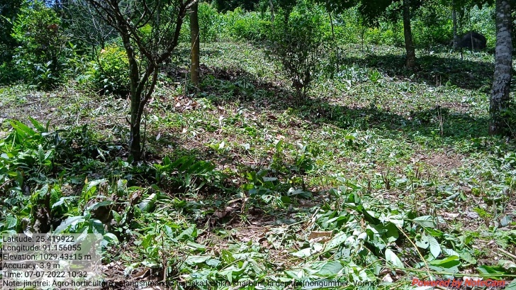
Fig: Agro-Horticulture at Langshmang 3
| 34. | Type Of Intervention | Site Name | GPS Co-ordinates | Amount Sanctioned | Work Status | |
|---|---|---|---|---|---|---|
| Agro-Holticulture | Langshangmang 4 | 25.418963 | 91.1565 | 25010 | Completed | |
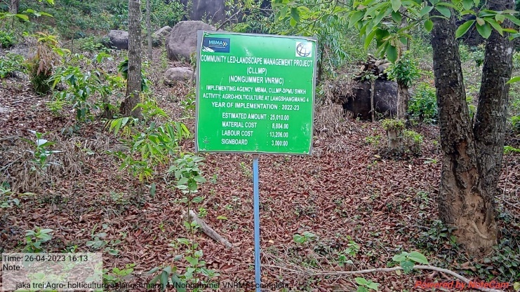
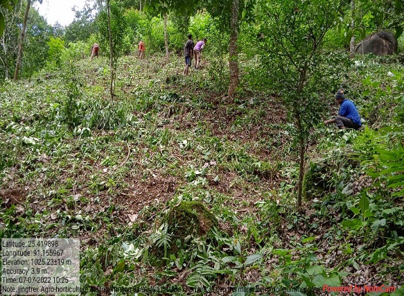
Fig: Agro-Horticulture at Langshmang 4
| 35. | Type Of Intervention | Site Name | GPS Co-ordinates | Amount Sanctioned | Work Status | |
|---|---|---|---|---|---|---|
| Agro-Holticulture | Warslo 1 | 25.409167 | 91.160092 | 25010 | Completed | |
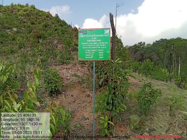
Fig: Agro-Horticulture at Warslo 1
| 36. | Type Of Intervention | Site Name | GPS Co-ordinates | Amount Sanctioned | Work Status | |
|---|---|---|---|---|---|---|
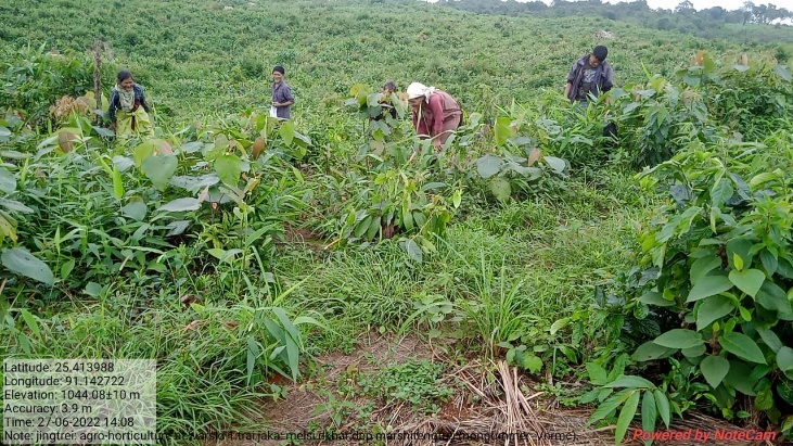
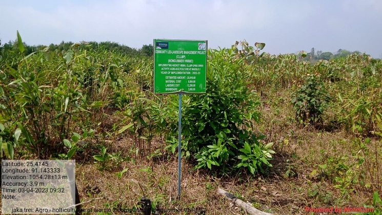
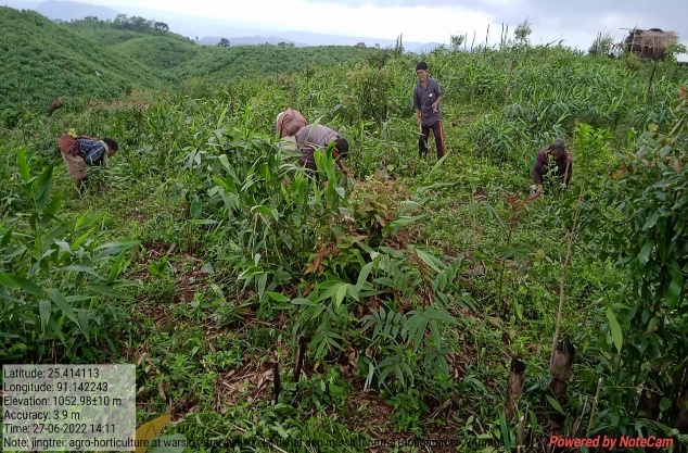
| Agro-Holticulture | Warslo 2 | 25.414113 | 91.142243 | 25010 | Completed | |
| 37. | Type Of Intervention | Site Name | GPS Co-ordinates | Amount Sanctioned | Work Status | |
|---|---|---|---|---|---|---|
| Agro-Holticulture | Warslo 3 | 25.413988 | 91.142722 | 25010 | Completed | |
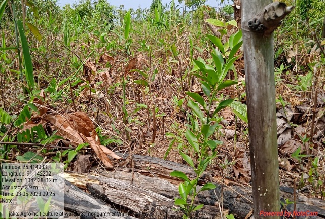
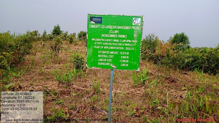
Fig: Agro-Horticulture at Warslo
| 38. | Type Of Intervention | Site Name | GPS Co-ordinates | Amount Sanctioned | Work Status | |
|---|---|---|---|---|---|---|
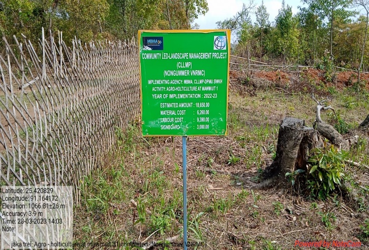
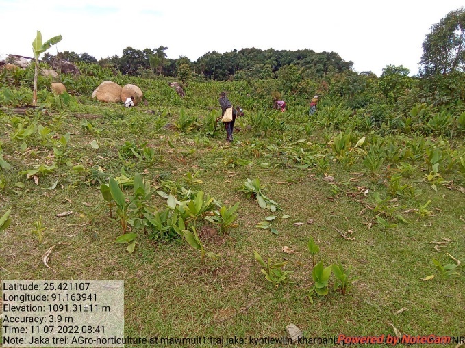
| Agro-Holticulture | Mawmuit 1 | 25.421107 | 91.163941 | 18650 | Completed | |
Fig: Agro-Horticulture at Mawmuit 1
| 39. | Type Of Intervention | Site Name | GPS Co-ordinates | Amount Sanctioned | Work Status | |
|---|---|---|---|---|---|---|
| Agro-Holticulture | Mawmuit 2 | 25.420712 | 91.16381 | 25010 | Completed | |
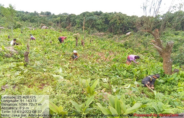
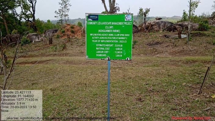
Fig: Agro-Horticulture at Mawmuit2
| 40. | Type Of Intervention | Site Name | GPS Co-ordinates | Amount Sanctioned | Work Status | |
|---|---|---|---|---|---|---|
| Agro-Holticulture | Mawmuit 3 | 25.422569 | 91.16289 | 35300 | Completed | |
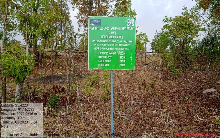
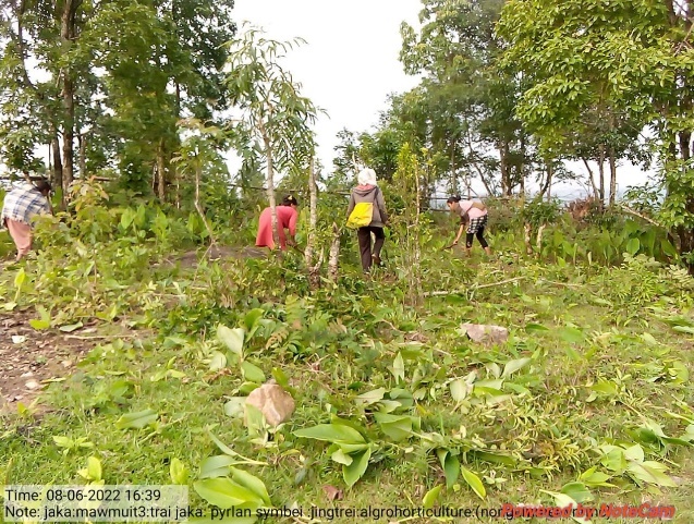
Fig: Agro-Horticulture at Mawmuit 3
| 41. | Type Of Intervention | Site Name | GPS Co-ordinates | Amount Sanctioned | Work Status | |
|---|---|---|---|---|---|---|
| Inter-Cropping | Poinlang 1 | 25.40238 | 91.157952 | 54300 | Completed | |
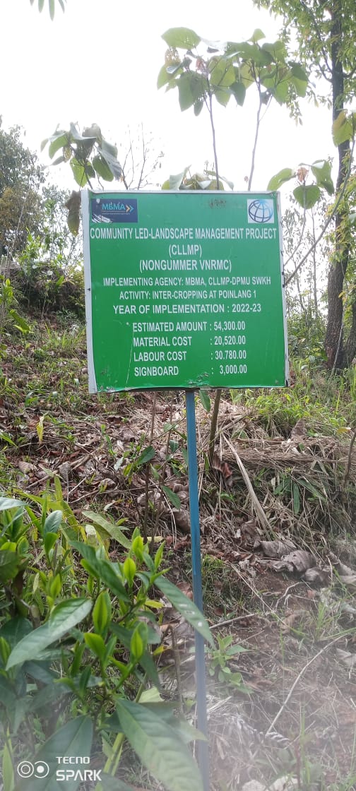
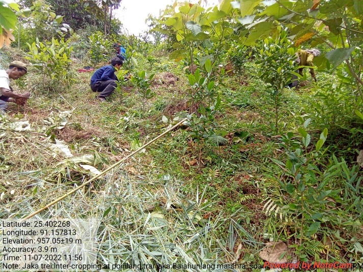
Fig: Inter-Cropping at Poinlang 1
| 42. | Type Of Intervention | Site Name | GPS Co-ordinates | Amount Sanctioned | Work Status | |
|---|---|---|---|---|---|---|
| Inter-Cropping | Poinlang 2 | 25.402274 | 91.157879 | 54300 | Completed | |
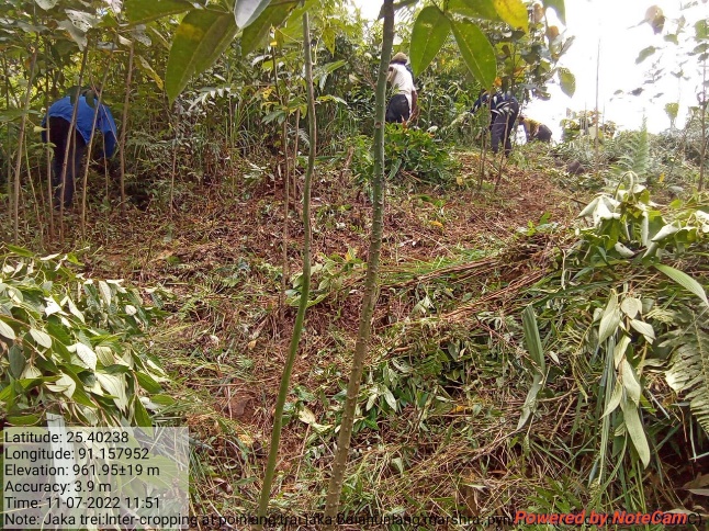
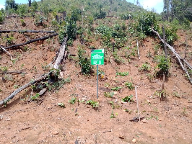
Fig: Inter-Croping at Poinlang 2
| 43. | Type Of Intervention | Site Name | GPS Co-ordinates | Amount Sanctioned | Work Status | |
|---|---|---|---|---|---|---|
| Inter-Cropping | Poinlang 3 | 25.409155 | 91.158143 | 54300 | Completed | |
| 44. | Type Of Intervention | Site Name | GPS Co-ordinates | Amount Sanctioned | Work Status | |
|---|---|---|---|---|---|---|
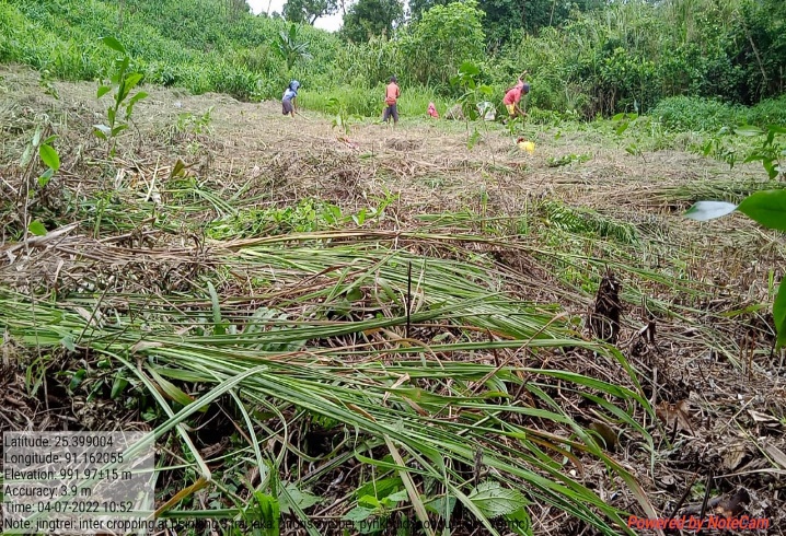
| Inter-Cropping | Poinlang 4 | 25.399063 | 91.162057 | 54300 | Completed | |
Fig: Inter Cropping at Poinlang 4
| 45. | Type Of Intervention | Site Name | GPS Co-ordinates | Amount Sanctioned | Work Status | |
|---|---|---|---|---|---|---|
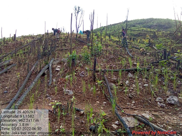
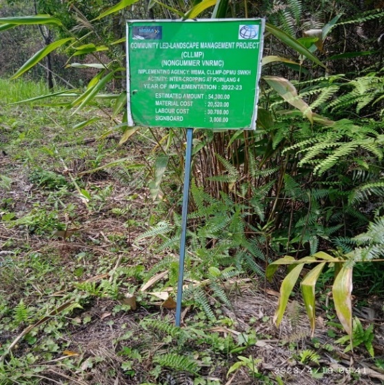
| HORTICULTURE | LANGSHMANG 1 | 25.421458 | 91.157505 | 18650 | Completed | |
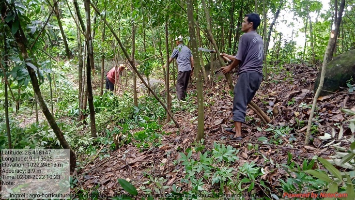
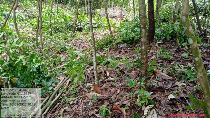
Fig: Horticulture at Lngshmang 1
| 46. | Type Of Intervention | Site Name | GPS Co-ordinates | Amount Sanctioned | Work Status | |
|---|---|---|---|---|---|---|
| INTER CROPPING | LANGSHMANG 1 | 25.42246 | 91.156681 | 39955 | Completed | |

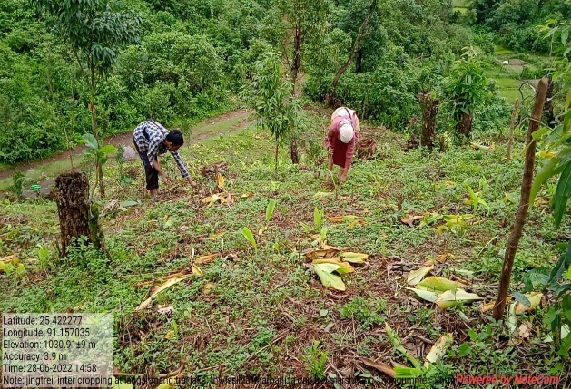
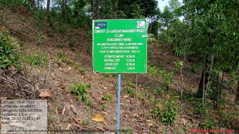 Fig: Inter Cropping
at Langshmang 1
Fig: Inter Cropping
at Langshmang 1
| 47. | Type Of Intervention | Site Name | GPS Co-ordinates | Amount Sanctioned | Work Status | |
|---|---|---|---|---|---|---|
| HORTICULTURE | NONGRIMTOD | 25.416019 | 91.165825 | 34300 | Completed | |

Fig: Horticulture at Nongrimtod
| 48. | Type Of Intervention | Site Name | GPS Co-ordinates | Amount Sanctioned | Work Status | |
|---|---|---|---|---|---|---|
| SPRING CHAMBER | UMTONGBAH | 25.414691 | 91.162803 | 80460 | Completed | |

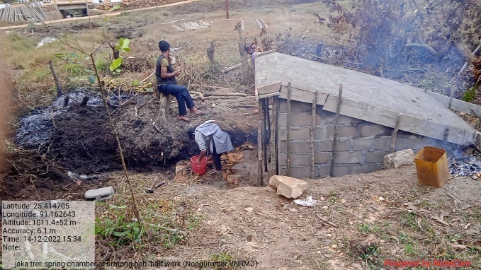
Fig: Spring Chamber at Umtongbah
11.Fund Status:
Fund Released to VNRMC (Project Implementation)- Rs.21,55,000 Total No. of Work Order Issued- 21 |
|||||
| Activity Name | Amount Sanction | Amount Spent | Work Order Issued Date | Start Date | End Date |
| Agro-Forestry at Jynrinmait | 97,400 | 97,400 | 12-Jul-21 | 12-Aug-21 | 31-Aug-21 |
| Agro-Forestry at Pyiur | 97,400 | 97,400 | 12-Jul-21 | 16-Aug-21 | 28-Aug-21 |
| Agro-Forestry at Thyllei | 47,500 | 47,500 | 16-Jul-21 | 16-Aug-21 | 28-Aug-21 |
| Agro-Forestry at Umteinlang | 97,400 | 97,400 | 12-Jul-21 | 18-Aug-21 | 31-Aug-21 |
| Agro-Horticulture at Khylo Khatek | 61,220 | 61,220 | 16-Jul-21 | 26-Aug-21 | 07-Sep-21 |
| Agro-Horticulture at Lawmerop | 47,500 | 47,500 | 16-Jul-21 | 09-Aug-21 | 14-Aug-21 |
| Agro-Horticulture at Nongmarshra | 97,400 | 97,400 | 12-Jul-21 | 16-Aug-21 | 28-Aug-21 |
| Agro-Horticulture Khenmot | 18,650 | 18,650 | 28-Mar-22 | 01-Jun-22 | 13-Jun-22 |
| Agro-Horticulture Langshmang 1 | 18,650 | 18,650 | 31-Mar-22 | 01-Jun-22 | 17-Jun-22 |
| Half Moon Terraces at Khylo Khatek | 65,700 | 65,700 | 12-Jul-21 | 02-Aug-21 | 03-Sep-21 |
| Half Moon Terraces at Nongrimtod | 15,150 | 15,150 | 12-Jul-21 | 18-Aug-21 | 19-Aug-21 |
| Loose Boulder Miangtymmen | 54,300 | 54,300 | 28-Mar-22 | 01-Jun-22 | 24-Jun-22 |
| Loose Boulder Poinlang 3 | 45,520 | 45,520 | 22-Oct-21 | 03-Jan-22 | 29-Jan-22 |
| Spring Chamber at Lawsynri | 44,500 | 44,500 | 12-Jul-21 | 01-Oct-21 | 03-Nov-21 |
| Spring Chamber Umtongbah | 80,460 | 80,460 | 06-May-22 | 03-Oct-22 | 14-Dec-22 |
| Spring Chamber Dongrisim | 43,340 | 43,340 | 12-Jul-21 | 01-Aug-21 | 30-Sep-21 |
| Agro Horticulture at Nongrimtod | 25,250 | 25,250 | 12-Jul-21 | 18-Aug-21 | 19-Aug-21 |
| Loose boulder bund atLangshmang 1 | 42,540 | 42,540 | 22-Oct-21 | 03-Jan-22 | 24-Jan-22 |
| Loose boulder bund at Poinlang 2 | 45,520 | 45,520 | 22-Oct-21 | 03-Jan-22 | 29-Jan-22 |
| Community Nursery | 1,64,950 | 1,64,950 | 28-Mar-22 | 18-Jun-22 | 02-Aug-22 |
| Inter Cropping at Thylle 1 | 54,300 | 54,300 | 28-Mar-22 | 01-Jun-22 | 30-Jun-22 |
| Agro Horticulture at Thylle 2 | 18,650 | 18,650 | 28-Mar-22 | 01-Jun-22 | 14-Jun-22 |
| Agro Horticulture at Wei Long Deng | 25,010 | 25,010 | 28-Mar-22 | 01-Jun-22 | 10-Jun-22 |
| Inter Cropping at Weilongdeng 1 | 39,955 | 39,955 | 28-Mar-22 | 07-Jun-22 | 27-Jun-22 |
| Agro Horticulture at Mawlong Khohroh | 25,010 | 25,010 | 28-Mar-22 | 01-Jun-22 | 10-Jun-22 |
| Agro horticulture at Lawmerop | 35,300 | 35,300 | 28-Mar-22 | 15-Jun-22 | 30-Jun-22 |
| Agro Horticulture at Khnokdek | 18,650 | 18,650 | 28-Mar-22 | 01-Jun-22 | 13-Jun-22 |
| Agro horticulture at Nongmarshra | 25,010 | 25,010 | 28-Mar-22 | 01-Jun-22 | 23-Jun-22 |
| Inter Cropping at Diangwang | 34,330 | 34,330 | 28-Mar-22 | 01-Jun-22 | 24-Jun-22 |
| Inter cropping at Mawkut Shynreh | 25,010 | 25,010 | 28-Mar-22 | 01-Jun-22 | 14-Jun-22 |
| Inter-Cropping at Rang Khla | 25,010 | 25,010 | 28-Mar-22 | 01-Jun-22 | 10-Jun-22 |
| Inter-Cropping at Miang Tymmen | 63,610 | 63,610 | 22-Oct-21 | 03-Jan-22 | 25-Jan-22 |
| Inter-Cropping at Mawstuphniaw | 34,330 | 34,330 | 28-Mar-22 | 01-Jul-22 | 25-Jul-22 |
| Agro-Holticulture at Langshangmang 2 | 25,010 | 25,010 | 28-Mar-22 | 15-Jun-22 | 27-Jun-22 |
| Agro-Holticulture at Langshangmang 3 | 25,010 | 25,010 | 28-Mar-22 | 01-Jun-22 | 15-Jun-22 |
| Agro-Holticulture at Langshangmang 4 | 25,010 | 25,010 | 28-Mar-22 | 01-Jun-22 | 13-Jun-22 |
| Agro-Holticulture at Warslo 1 | 25,010 | 25,010 | 28-Mar-22 | 01-Jul-22 | 18-Jul-22 |
| Agro-Holticulture at Warslo 2 | 25,010 | 25,010 | 28-Mar-22 | 01-Jun-22 | 18-Jun-22 |
| Agro-Holticulture at Warslo 3 | 25,010 | 25,010 | 28-Mar-22 | 01-Jun-22 | 14-Jun-22 |
| Agro-Holticulture at Mawmuit 1 | 18,650 | 18,650 | 28-Mar-22 | 13-Jun-22 | 28-Jun-22 |
| Agro-Holticulture at Mawmuit 2 | 25,010 | 25,010 | 28-Mar-22 | 21-Jun-22 | 30-Jun-22 |
| Agro-Holticulture at Mawmuit 3 | 35,300 | 35,300 | 28-Mar-22 | 01-Jun-22 | 17-Jun-22 |
| Inter-Cropping at Poinlang 1 | 54,300 | 54,300 | 28-Mar-22 | 01-Jul-22 | 14-Jul-22 |
| Inter-Cropping at Poinlang 2 | 54,300 | 54,300 | 28-Mar-22 | 01-Jul-22 | 15-Jul-22 |
| Inter-Cropping at Poinlang 3 | 54,300 | 54,300 | 28-Mar-22 | 01-Jun-22 | 12-Jun-22 |
| Inter-Cropping at Poinlang 4 | 54,300 | 54,300 | 28-Mar-22 | 01-Jun-22 | 15-Jun-22 |
| Inter Cropping at Langshmang 1 | 39,955 | 39,955 | 31-Mar-22 | 01-Jun-22 | 15-Jun-22 |
| Horticulture at Nongrimtod | 34,300 | 34,300 | 31-Mar-22 | 03-Jun-22 | 15-Jun-22 |
Ground Testimonials:
Livingstone Symbei
VCF M & E Nongummer
As a VCF of Nongummer VNRMC, I would like to express few words of appreciation towards the CLLM Project in my village. With many interventions that had been implemented with the objectives of conserving land, water and forest, the community members within the village have become more aware and considerate towards the environment. I have also attended many trainings which have brought much benefit to me personally.
Donbor Marshra
VCF Environment Nomgummer
From this Project I have been benefitted personally as I can test the quality of the water, pH level, water discharge, etc., with the water tracer and fill the information on the Spring Survey App which I do monthly. I also follow up quarterly on the survival rate of all plantation works and as being taught by the Staffs and External experts, I have learned the use of Note Cam App whenever I go for site visitation. I feel blessed to have worked with this office that oversees the development and management of the natural resources within the village.
Jaijaibel Dkhar
VCF SM & KM
As a VCF SM & KM of Nongummer VNRMC I would like to experess my gratitude towards the CLLM Project. With the funding from the World Bank, we have seen much changes within our villages in matters relating to the implementation of the various activities aiming at conservation of our surroundings. All activities and intervention received from the office have been benefitted by every resident of our village. I have learned to maintain all the registered needed by the Office, and I have attended many trainings conducted by the Office.
5