Report on
Photjaud RANGTHONG Village under MAWKYRWAT C&RD block
District: SOUTH WEST KHASI HILLS
COMMUNITY LED LANDSCAPE MANAGEMENT PROJECT


The Government of Meghalaya with the financial help from the World Bank has been implementing the Meghalaya Community Led Landscape Management Project (MCLLMP). The project covers the entire state of Meghalaya and implementation of community led plans have been rolled out in phase manner throughout the state. The Meghalaya Basin Management Agency (MBMA) had facilitated the community-led planning by providing support, technical inputs and funding.
The project had strengthened community-led natural resources management in selected landscapes within the 12 districts of the state. This has been achieved through a variety of planning, capacity building, and on-the-ground interventions to promote the conservation, sustainable use of natural resources, social inclusion and community mobilisation; building traditional knowledge and learning, mapping of natural resources management; strengthening the community institutions and creating linkage with financial institutions and community organizations.
The project interventions include the preparation of community led natural resource management plans. The CLLMP has the following three components:
Strengthening Knowledge and Capacity of Communities for Natural Resources Management
Community-Led Landscape Planning and Implementation
Project Management and Governance
The project objective is “to manage and conserve the natural resources, especially forests, soil and water sources, in a manner that supports the financial and physical well-being of communities in the State”
SCOPE:
The CLLM-Programme focuses on increasing the capacities of communities and traditional institutions (TI) by adopting a landscape approach to manage their natural resources such as soil, springs and other water sources, forests and bio-diversity, etc.
The project has been planned and implemented in about 400 villages across the state.
CLLMP has a strong focus on institution-building at the village-level, by ensuring systematic capacity-building on technical and social skill-sets.
The project has also extended such trainings to communities beyond the targeted villages and support efforts made by them to access funding from various rural and natural resources initiatives and schemes.
The programme has also invested in improving the process and outcome delivery, by developing and adhering to effective systems and procedures, supported by the appropriate technology.
BENEFITS:
Benefits for community (Skills and Capacity relating to technical and managerial areas like NRM and Conflict resolution
Benefits to traditional institutions (village councils, traditional leaders, community-based organizations, SHGs etc) through Knowledge sharing, promotion of innovative approach, access to technology, technical managerial and financial support.
It has been estimated that the project has impacted around 1 lakh partners (of which 50% are women) who depend on land, forest, agro forestry.
Through the project, 55000 Ha of targeted area has been ensured with availability of water, biological resources and soil productivity, which has in turn benefitted around 400 villages and the outcomes delivery can be summarized as follows.
IMPLEMENTATION AGENCY:
The Project has been executed by the MBMA in collaboration with other partners particularly, SIRD (for training and capacity building), Department of Soil and Water Conservation, Water Resource Department, Forest Department, specifically with respect to technical inputs, safeguards management and Community NRM plan preparation.
PROJECT PERIOD:
2018-2023 (5 years)
Table of contents:
Introduction & Village History………………………………………. 5-6
Social Profile …………………………………………………………. 6
Village Accessibility…………………………………….. 6
Literacy rate……………………………………………. 6
Population……………………………………………... 6-7
Occupation…………………………………………….. 7
Village organisation……………………………………. 7
Fuel Type……………………………………………… 7
Drinking Water………………………………………... 8
Cultivatable Land……………………………………… 8
Forest Cover……………………………………………. 8
Forest Species…………………………………………… 8
Water Bodies……………………………………………. 8
Areas affected…………………………………………. 9
III. CLLMP Activities
Ground-Truthing…………………………………………………. 9
Sensitization on CLLMP………………………………………… 9
Signing of EOI, VGA and Green Charter………………………. 10
Formation of VNRMC…………………………………………... 10
Village Community Facilitators…………………………………. 11
Purchase Committee …………………………………………….. 11
IV. Opening of Bank Account …………………………….………………. 12
V. PRA Exercise…………………………………………………………… 13
Basic Survey for CNRMP template……………………………… 14
Focussed Group Discussions…………………………………… 14-15
Village Boundary Mapping and Resource Mapping…………… 16
VI. GIS Activities…………………………………………………………… 16-18
VII. The Proposal list of intervention………………………………………… 19-20
VIII. Project Implementation ………………………………………………... 21-36
IX. Fund Status ……………………………………………………… 37-38
X. Ground Testimonials ……………………………………………… 38
INTRODUCTION:
Photjaud Rangthong village is situated in South West Khasi Hills District under the Mawkyrwat C&RD Block. The village is about 13 Km away from the District Headquarters i.e., Mawkyrwat and about 13 Km away from the Block Headquarters. It has a total geographical area of 816.62Ha and falls under the Hima Maharam Syiemship. Photjaud Rangthong village has a total population of 944 comprising of 481 males and 463 females. All the residents of Photjaud Rangthong village belong to the Khasi Scheduled Tribe. The average rainfall of Photjaud Rangthong village is 12000mm and the type of soil is mainly Loamy soil.
BRIEF HISTORY OF THE VILLAGE:
Photjaud Rangthong village is under the Hima Maharam Syiemship. “Phot” literally means “River” while “Jaud” is a green plant that grows on the river side and that was how this village gets the name “Photjaud” and “Rangthong” gets its name from the person who bets, and the story is that there was a bet to whom could make a person’s mouth water, people from all over came to compete and brought all types of food that could possibly make a mouth-watering delight but, all failed and it was only one person from Photjaud Rangthong who achieved this feat by bringing to the competition a ‘lemon’, hence the name Rangthong.
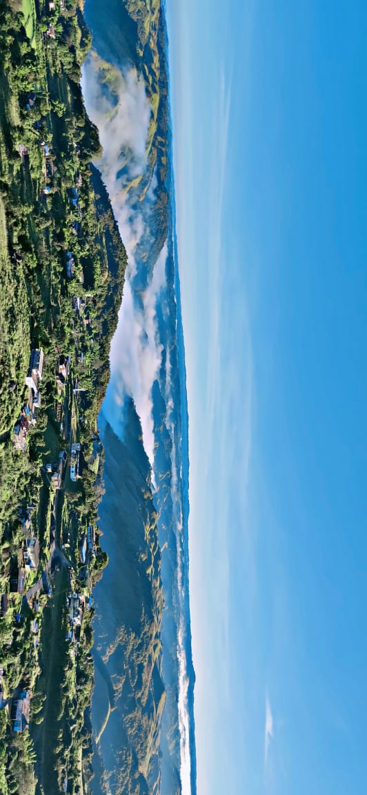
Fig: Photjaud village.
VILLAGE SOCIAL PROFILE:
Photjaud Rangthong village has a total number of 142 households, having a total population of 944 villagers. People in this village mainly depend on agriculture and its allied activities for their livelihood. There are teachers, daily labourers but the majority of the villagers depend mostly on agricultural farming.
Village Accessibility:
To reach Photjaud Rangthong village one must travel through road with local taxis, Maxi cabs from the Mawkyrwat-Ranikor road via Nonglang village.
Literacy Rate:
In Photjaud Rangthong, there are a total number of 5 schools out of which 4 are Primary Schools and there is 1 Secondary School in the village. Many of the people are literate.
Population:
The total population of Photjaud Rangthong village now stands at 944 as of the recent survey. Out of this, 481 are male and the female count is 463.This village has 146 children belonging to the group 0-4years and 39 people are above the age of 60. About 261 total number of people belong to the age group of 30-60 years, and 15-30 years are the age group that comprises of a total of 261 people. Thus, this indicates that most of the population of Photjaud Rangthong village comprise of the young and healthy people.
| Age Group | Male | Female | Total |
|---|---|---|---|
| 0-4years | 79 | 67 | 146 |
| 5-14years | 129 | 108 | 237 |
| 15-30years | 111 | 150 | 261 |
| 30-60years | 146 | 115 | 261 |
| Above 60years | 16 | 23 | 39 |
| Total | 481 | 463 | 944 |
Occupations:
The people of Photjaud Rangthong village rely mainly on agriculture and forest produce for their livelihood. Out of 142 households within the village, 100 household are farmers, 20 household are teachers, while the remaining 17 household are landless labourers and 5 households are officers/govt. servants.
V. Organisation within the Village:
There are 9 Self Help Groups (SHGs) under NRLM in Photjaud Rangthong village under one Village Organisation. Presence of a committee relating to Water and Sanitation within the village. There are also 12 VEC & traditional institutions within Photjaud Rangthong village.
VI. Fuel Type:
The people of Photjaud Rangthong village mainly uses wood as a fuel. About 170 households depend on wood gathered from the forest for their daily requirement.
| Type of Fuel | Total No of HH | Qty (Kgs/HH) | Total |
|---|---|---|---|
| Wood | 140 | 6000kg | 840000kg |
| Charcoal | 0 | 0 | 0 |
| LPG | 2 | 3cylinder 1 year(2400kg) | 4800kg |
VII. Drinking Water:
The people of Photjaud Rangthong have access to drinking water mainly from the springs within the village. Government water supply lines are also available in this village. But over the years there has been a scarcity of water supply in this village due to less water discharge from the springs source and due to the increase in human population and their daily requirements. There are 5 springs which fall under the community land within the village which are perennial that people use for drinking viz. Kyllai Lamar, Domphotkhniang, Photbah, Photburom and Phot Jynmu in which all household are depended on.
VIII. Cultivable Land Cover:
The total agricultural area of Photjaud Rangthong village is 21.77Ha. The type of soil in Photjaud Rangthong village is Loamy soil. People practise bun cultivation and shifting cultivation in their own private lands. The main cash crop of Photjaud village is Broomstick. Most of the land’s falls under private ownership. The areas that people cultivate broom are Nongbsaw, Mawtemksein, Wahdilin, Wahleper and Raiiawlam. They also plant other cash crops such as beetle leaf and bay leaf. The areas that people practise shifting cultivation for a period cycle of 3years on are: Malkhrang, Breikhrew, Breisyien, Kaintangbew, Photditung.
IX. Forest Cover:
The total forest cover under Photjaud Rangthong village is 422.77 Ha. 90.24 Ha falls under Open Forest and 332.53 Ha falls under Dense Forest. Most of the forest cover falls on the Community Forest. The name of the community forests is: Traw iamrin, Langpyrdew, Sdoit domkseh, Kupomblang, Wahlbong, Sohkhynra, Photsyngkai. People uses the forest products mainly for fuelwood, as medicines, aromatic plants and for other purposes. There is one Private Forest at Lyngdohiewkad which is an open forest. There is also a protected forest at Langpyrdew which is a dense forest.
X. Forest:
Some of the indigenous tree species found in this village are Diengksehblei, Diengrai ian, Diengrai kup, Diengrai sohniuh, Diengtanglung, Diengsningiong, Diengsning sohstab, Diengsning lieh, Diengngan buid, Diengngan heh, Dienglieng, Dienglyniar, Diengsohshit, Diengkseh. There are some plant species used by the people of the community for medicinal purposes like Diengsoh phie, Diengsohiong, Diengsohshit, Diengsohrwe, Diengsnapmaw, Diengsohsyrtet, Dienglangkurop. Some of the commercially valued trees in the forest are Diengsning, Diengrai, Diengtanglung, Diengkseh.
XI. Water Bodies:
Total area of water bodies in Photjaud Rangthong is 5.95Ha. There are 5 springs within the village which have been mentioned above which people use mainly for drinking purpose. Some of the streams within the village are Twah iawmeiiong, Twah photthangdkhep, Twah iemrim, wah shaid shaid, Twah photsohmyrsiang, Phot Ku Pomblang, Twah sdoit nongphet, photsohkhynrah which falls under the community land. All the streams are perennial. One river runs within the village’s geographical area i.e., Wah riling.
XII. Areas Affected:
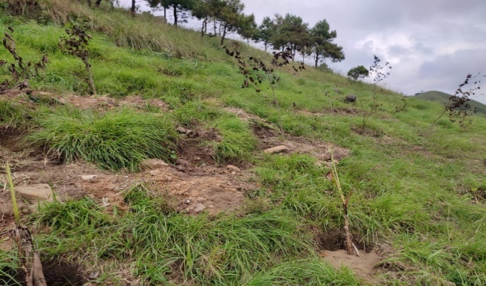
Approximately about 23.68ha of forest land have been degraded over the years due to soil erosion, 2.56ha due to forest fires, 5.5ha excessive felling of trees and 11ha have been degraded due to Jhum practises which have led to the loss of productivity of the land and the loss of the saplings and other natural resources. About 1.23ha of cultivable land have been affected by the excessive use of fertilizers and 24.12ha of land have been degraded over the years owing to human settlement and culturable wastelands.
CLLMP ACTIVITIES:
1.Ground Truthing: The CLLMP officials met with Mr. headman of Photjaud Rangthong village, Mr. Phedarlyne Nongsiej the village Secretary and other village representatives for field assessment. Mr. Phedar, provided the CLLMP Team with important information regarding the current scenario of the landscape and the natural resource management under his headman ship.
Case Findings:
i)Most of the household falls under the BPL category.
ii)They have an actively performing VEC in the village.
iii)The land within the village falls under the Hima Maharam Syiemship.
iv)The source of water supply in the village is from two sources: private and public.
v)There are a few patches of degraded land that has been left unused.
vi)There is a loss of Natural Vegetation in the area.
vii)Abundance of small streams within the village.
2.Sensitization Programme:
The District Project Manager Mr. J. Wanniang along with the staff held a village Level Sensitization Programme on the Community Led Landscape Management Project (CLLMP) on 28th June 2019.The villagers actively participated in the program, voicing out their concerns and questions regarding the project making it a huge success.
Highlights of the meeting:
1.Awareness about the Community Led Landscape Management Project (CLLMP).
2.Laying the importance on the involvement of the community in making the CNRM plan and its success.
3.A brief awareness on cleanliness was conducted based on our finding during the ground truthing phase.
4.An interactive session was held to answer doubts of the villagers regarding the project.
3.Signing of EOI, VGA and Green Charter:
On 28th June 2019, Photjaud Rangthong village signed the EOI (Expression of Interest), VGA (Village Grant Agreement) and the Green Charter after there was a uniform agreement by the people of the entire Community that the Community Led Landscape Management Project (CLLMP) be implemented at Photjaud Rangthong village.
4.Formation of the VNRMC:
The formation of the Village Natural Resources Management Committee was done in a public meeting on the 28thJune 2019 in the presence of the entire village and the CLLMP Staff. The people of the community chose the President, The Secretary, the Purchase Committee members, and the other Executive members to form the Photjaud Rangthong VNRMC. There are 9 Executive members, 3 Village community Facilitator and 3 Purchase Committee members. The VNRMC Plan was later formulated on the 24thAugust 2019 in the presence of the VNRMC members.
List below are the members of the VNRMC:
| Village Natural Resource Management Committee (9members committee constituted from Village Council, SHG group, Women’s group, youth, VEC) | ||||||||
|---|---|---|---|---|---|---|---|---|
| Sl No. | Name | Designation | Gender (M/F) |
Age in years | Qualification | Occupation | Community | Phone No. |
| 1. | Phyrnaistar Syiemlieh | President | Male | 36 | BA | Teacher | Khasi | 9485151027 |
| 2. | Ailomina Thongni | Secretary | Female | 40 | X | Housewife | Khasi | 9485153574 |
| 3. | Calbinson Nongsiej | Finance | Male | 35 | BA | Labourer | Khasi | 8837268687 |
| 4. | Aidaris Wanniang | Member | Female | 43 | IV | Farmer | Khasi | 9863188079 |
| 5. | Nainty Syiemlieh | Member | Female | 45 | IV | Farmer | Khasi | NA |
| 6. | Cheerfullness Iawphniaw | Member | Female | 42 | VIII | ASHA | Khasi | 9485146048 |
| 7. | Thindar Lyngkhoi | Member | Male | 48 | VI | Farmer | Khasi | 9856381419 |
| 8. | Gilbert Thyrniang | Member | Male | 40 | VII | Labourer | Khasi | NA |
| 9. | Kaldius Shangdiar | Member | Male | 56 | III | Farmer | Khasi | 8974365323 |
| Village Community Facilitators (VCF) | ||||||
|---|---|---|---|---|---|---|
| Sl no. | Name | Age | Gender | Qualification | Contact Number | Role |
| 1. | Sirian Syiemlieh | 60 | Male | BA | 9366907574 | Social & KM |
| 2. | Aloysius Syiemlieh | 32 | Male | X | 8787756778 | Document & ME |
| 3. | Margret Thongni | 28 | Female | BA | 8414066783 | Envt & GIS |
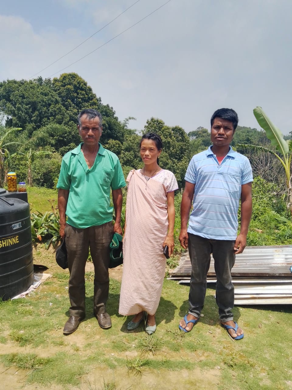
Fig: VCF of Photjaud Village.
| Procurement Members | |||||
|---|---|---|---|---|---|
| Sl no. | Name | Age | Gender | Qualification | Contact Number |
| 1. | Artison Syiemlieh | 37 | Male | X | 9485153574 |
| 2. | Lista Thongni | 40 | Female | IX | NA |
| 3. | Phridolin Marwein | 35 | Male | XII | NA |
5.Opening of Bank Account:
The opening of the bank account was done after the signing of the EOI (Expression of Interest), the VGA (Village Grant Agreement) and the signing of the Green Charter.
The Accountant of CLLMP South West Khasi Hills trained the Purchasing and Procurement Committee of Photjaud village on matters relating to Accounts and Book Keeping and on the:
Principles of Community Procurement
Benefits of Community Procurement
Important aspects undertaken by Community Procurement.
Procurement Process/Steps
Function of Purchase Committee
Important Procurement records to be maintained
Financial limits and methods
Maintaining of Books of Accounts to the Book Keeper.

Fig: Bank details of Photjaud Rangthong VNRMC.
6.Participatory Rural Appraisal Exercise:
The PRA exercise aims to incorporate the knowledge and opinions of the community in the planning and management of development projects and programmes.
The PRA exercise took place on the 1st July 2019 both men and women attended the program.
The District Project Manager gave the introduction and spoke about the different activities that the participants had to take part in the programme.
The Program Associate, Environment Management, spoke about the different CNRM plans and the different types of intervention. A group of participants interacted and helped in the collection of data based on the environmental template. With the help of this group, different sites of interventions were identified, analysed and evaluated in order to prioritized the areas that needed the natural resources management.
The Assistant Manager, Social Management, gathered the remaining group of participants to gather the baseline data bases on the social template.
The main objectives of PRA exercise are:
To identify the natural, human and economic resources of the village.
To identify the village problems and prioritized them with the help of the community members.
To prepare the community natural resources management plan of the village.
Findings based on the information gathered from the participants during the PRA/CNRMP exercise:
1.The main agricultural produce is Broomstick, Beetle leaf and Bay leaf.
2.Most of the household depend on firewood as a source of fuel.
3.Drinking water is limited over a period of 3-4 months during the winter season.
4.There are two types of forest ownership: Community and Clan.
5.There is one Protected Forest.
6.The springs which are present in the village needs rejuvenation.
7.Training on Land productivity, Spring shed management and Community nursery is necessary for the village community.
8.There are no disputes/constraints encountered within the village community or with any neighbouring villages.
Priorities Intervention required based on the PRA Exercise:
1.Rejuvination of the Springs within the community through activities such as afforestation, treatment of catchment areas and contour trenches.
2. Afforestation, Bio-fencing and fire line control in the community forest.
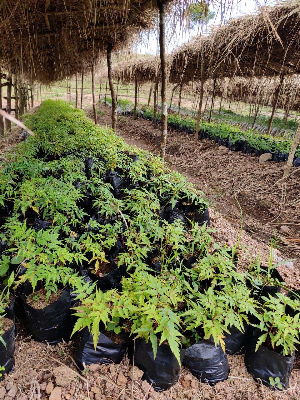
3.Community Nursery for endemic trees.
4.A dug out pond for collecting rain water for.
5.Check dams for erosion control.
6.Culturable wastelands to be brought under horticulture.
7.Retaining wall in some area in the village to prevent soil erosion.
Baseline Data Survey to fill the Environment and Social Template:
During the PRA Exercise the External Expert of Social & Environment Management held a group discussion with the different groups to gather basic village information regarding number of households, demographic information, major crops and enterprises taken in the village, trends of production and productivity of major crops in the village and demographic distribution of village population.
Information related to land use category such as forest, cultivable land, water bodies, etc and the problems and challenges related to NRM were discussed.
Focussed Group Discussion on Problem Analysis:
1.Do people have sufficient access to supply of fodder, fuel wood, leaf litter?
No, people in the village do not have sufficient access to supply of fodder, fuel wood, leaf litter.
2. Has access to timber improved or reduced over the years? How is access for household use and commercial use managed?
Access to Timber has reduced over the years. People have to purchase it from neighbouring village when needed.
3.Are the water bodies facing any threats?
So far, the water bodies within the village have faced some minor threats.
4. Do all people in the village have access to drinking water? What are the challenges?
Yes, there is sufficient drinking water in the village except during the winter season due to from December up to March due to less discharge of water from the spring source.
5. Are there degraded areas in the village (open/ degraded forests, mining affected, high soil erosion etc.)?
There are some minor degradations in cultivated land.
6. What has caused this degradation? Are there practices causing threats to availability and access to natural resources?
Fertility of the soil has decline over the year.
The practices that cause threat to the availability of these resources is:
Excessive practice of Jhum Cultivation
7. What have been the changes in agricultural practices?
Previously their method of farming is Shifting Cultivation, but over the years with much awareness people have begun to understand the effects of Jhum Farming method.
8.Are there any challenges in farming?
The main challenges faced by the people of Photjaud Rangthong village is that over the years they have seen a decline in the soil productivity due to soil erosion and other plant diseases and pest that destroy their crops.
9. How would you consider the health situation in your village?
The nearest health care is in the district headquarter with a distance of 11Km away and is easily accessible for the community as a whole to commute to the health centre.
10.How is the situation of cleanliness, sanitation, access to toilets and waste management?
Sufficient toilets are available in every household but most of the constructions are poor. Some households have access to toilets from SBM (Swash Bharat Mission) scheme. The presence of VWSC in the village has also improve sanitation and cleanliness. But Waste Management is poor because people are not really aware of how to properly disposed of waste.
11.Who are the most vulnerable in the village? What can be done to improve their lives?
BPL Families. Inclusion of BPL family members during project implementation
12. What are the livelihood aspirations of the youth? Are there any avenues available?
None, except daily wages labourers.
13. Do any committees/ institutions/ rules exist to manage and monitor natural resources in the village?
The VNRMC under the CLLMP is the main committee that is now in place to manage the natural resources in the village.
14.What are some of the major issues of conflict in the village?
Nothing related to NRM.
15.Have any of the above issues been discussed in village meetings?
NA
16. How do people resolve disagreements and conflicts?
All disagreements and conflicts are addressed by the traditional institution of village called the Village Dorbar.
7.Village Boundary Mapping and Recourse Mapping:
The GIS personnel along with the Village Community Facilitators mapped the village boundary of Photjaud Rangthong village.
The village resource map is prepared by the people of the community. In this resource map, the local people prepare it by drawing it on chart paper. Recourses such as agricultural lands, wells, wastelands, cattle population, playgrounds, ICDS, churches, community halls, etc were mapped.
8.GIS Activities:
| Sl. No. | Parameters | Village Information |
|---|---|---|
| 1 | GPS Coordinates: | |
| i | Latitude | 25.35368 |
| ii | Longitude | 91.390153 |
| iii | Elevation Reading (MSL) | 1529 |
| 2 | Village Geographical Area (Ha) | 816.62 ha |
| i | Total Forest Area (including community, Clan, Pvt Forest) | 422.77 Ha |
| ii | Total Area of Water Bodies | 5.95Ha |
| iii | Total Area under Agri-Horticulture | 1.37Ha |
| iv | Total Degraded land area (Ha) | 68.42Ha |
| 3 | Average Annual Rainfall | 1200mm |
| 4 | Soil Type | Loamy soil |
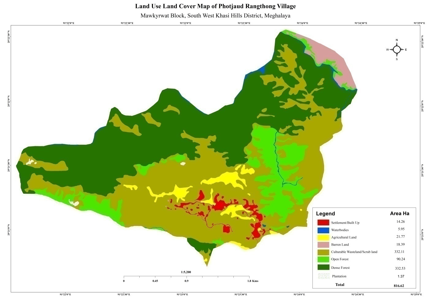
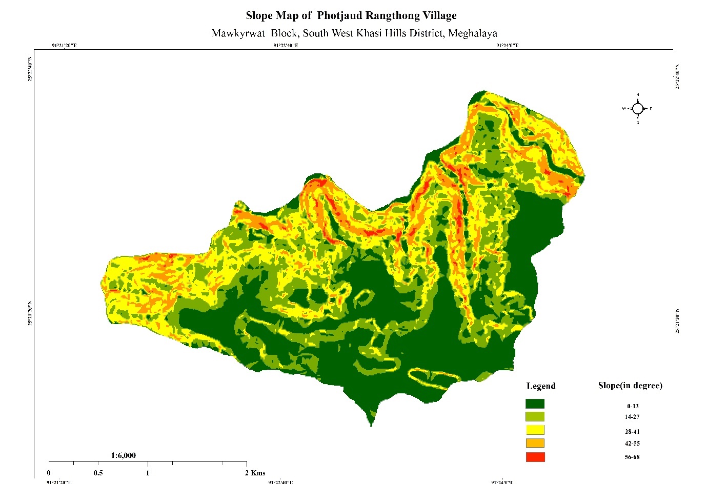
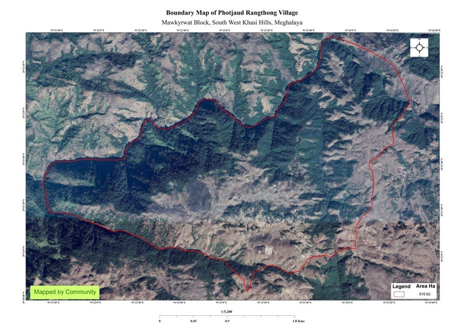
Fig: Boundary map, LULC map and Slope map of Photjaud Rangthong.
9. The Proposed list of Interventions:
|
Name of Proposed Interventions | Site |
|
Nos of HHs expected to Benefit | Priority (High/ Medium/ Low) |
|---|---|---|---|---|---|
|
|||||
| 1. | Treatment of Catchment Area | Domphotkhniang, Photjaud Rangthong |
|
|
|
| 2. | Construction of Spring Chamber and treatment of catchment area | Jynmu, Photjaud Rangthong |
|
|
high |
| 3. | Check Dam | Thwekaton, Photjaud Rangthong |
|
|
high |
| 4. | Afforestation | Nongrim |
|
|
high |
| 5. |
|
Domthwekaton |
|
|
high |
| 6. |
|
Domnongtwah |
|
|
high |
| 7. | Construction of Spring Chamber and Treatment of Catchment area | Photbah, Photjaud Rangthong. |
|
|
High |
| 8. | Construction of Spring Chamber and Treatment of Catchment area | Domphotkhniang (Dongsharum), Photjaud Rangthong |
|
|
High |
| 9. | Construction of Spring Chamber and Treatment of Catchment area | Phot Kyllai Lamar, Photjaud Rangthong. |
|
|
high |
| 10. | Construction of Spring Chamber | Photburom, Photjaud Rangthong |
|
|
high |
| 11. | Construction of GULLY PLUGS | Kperkohbor, Photjaud Rangthong |
|
|
high |
| 12. | Community Nursery | Photjaud Rangthong |
|
|
high |
| 13. | Construction of Spring Chamber and Treatment of Catchment area | Photbah, Photjaud Rangthong. |
|
|
high |
| 14. | Fireline | AT Twah Meiong-Phot Syngkai |
|
|
high |
| 15. | Fireline | AT Twah Meiong-Phot Syngkai |
|
|
high |
| 16. | Fireline | Trawiamrin-Domdisohphoh |
|
|
high |
| 17. | Afforestation | Mawiawan |
|
|
high |
| 18. | Afforestation | Domkynjang |
|
|
high |
| 19. | Afforestation | Domkseh |
|
|
high |
| 20. | Check dam | Sdoit photbah |
|
|
high |
| 21. | Check dam | Pepkohbor |
|
|
high |
| 22. | Construction of Spring Chamber and Treatment of Catchment area | Phot per a chin |
|
|
high |
| 23. | Construction of Spring Chamber and Treatment of Catchment area | Phot muri |
|
|
high |
| 24. | Construction of Spring Chamber and Treatment of Catchment area | Phot dipe |
|
|
high |
| 25. | Dug out pond | Kyllai lamar |
|
|
high |
| 26. | Dug out pond | Twah pyrsait |
|
|
high |
| 27. | Soil & water conservation activity | umburom |
|
|
high |
| 28. | Soil & water conservation activity | Sdoit photbah |
|
|
high |
10. PROJECT IMPLEMENTATION:
| 1. | Type Of Intervention | Site Name | GPS Co-ordinates | Amount Sanctioned | Work Status | |
|---|---|---|---|---|---|---|
| Check Dam | Thwekaton/ Kperkohbor |
25.356074 | 91.387246 | Rs.4,05,500 | Completed | |
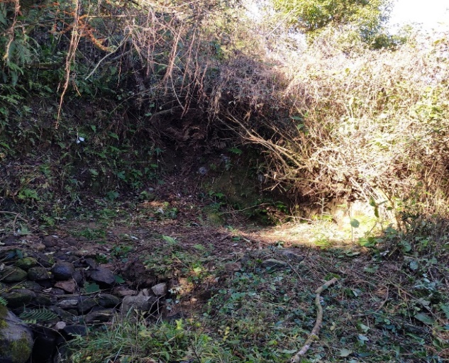
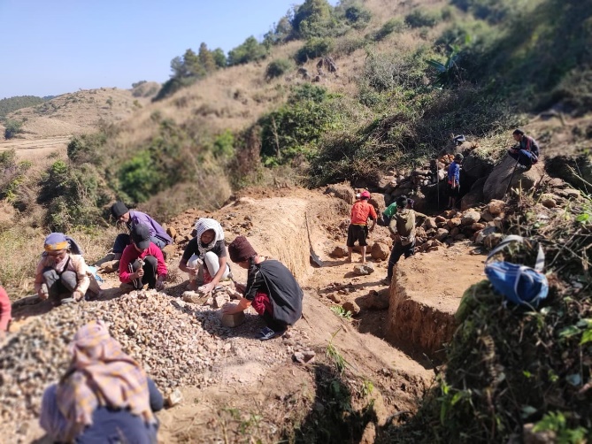
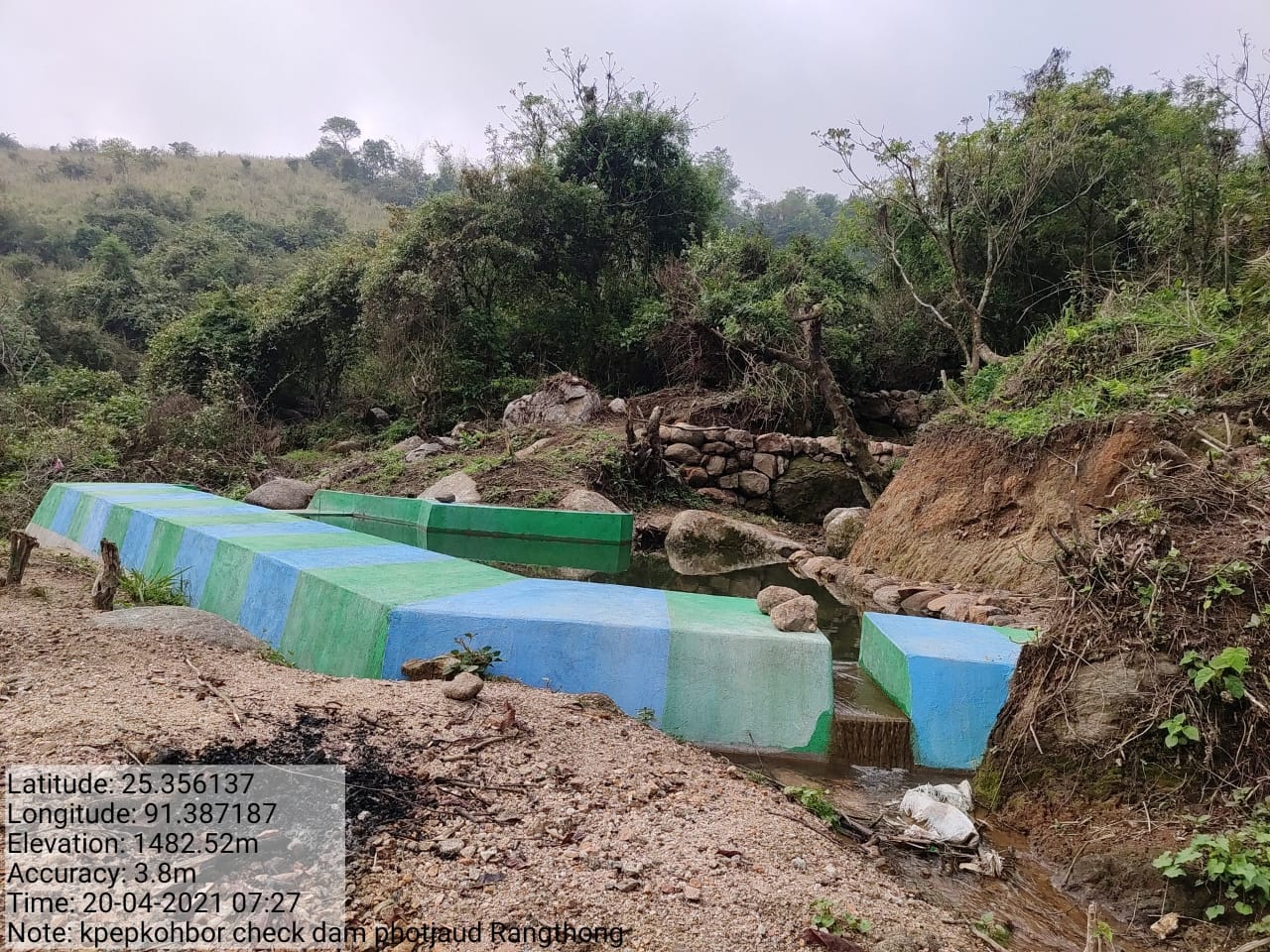
Fig: Construction of Check Dam at Kperkohbor.
| 2. | Type Of Intervention | Site Name | GPS Co-ordinates | Amount Sanctioned | Work Status | |
|---|---|---|---|---|---|---|
| Afforestation | Nongrim | 25.352406 | 91.390682 | Rs. 54,750 | Completed | |
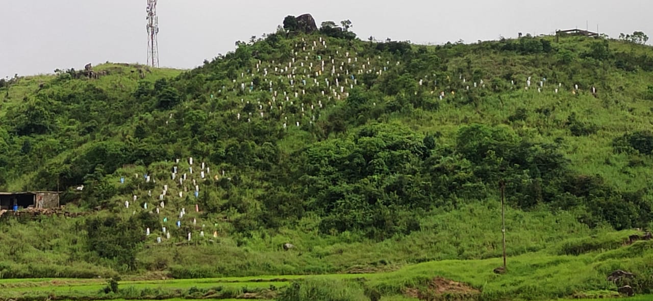
Fig: Afforestation at Nongrim.
| 3. | Type Of Intervention | Site Name | GPS Co-ordinates | Amount Sanctioned | Work Status | |
|---|---|---|---|---|---|---|
| Afforestation Treatment of catchment area | Domphotkhniang | 25.355088 | 91.381061 | Rs.3,500 | Completed | |
Fig: Treatment of Catchment Area at Domphotkhniang.
| 4. | Type Of Intervention | Site Name | GPS Co-ordinates | Amount Sanctioned | Work Status | |
|---|---|---|---|---|---|---|
| Fireline | Twah Meiong-phot Syngkai | 25.356368 | 91.384893 | Rs.1,19,000 | Completed | |
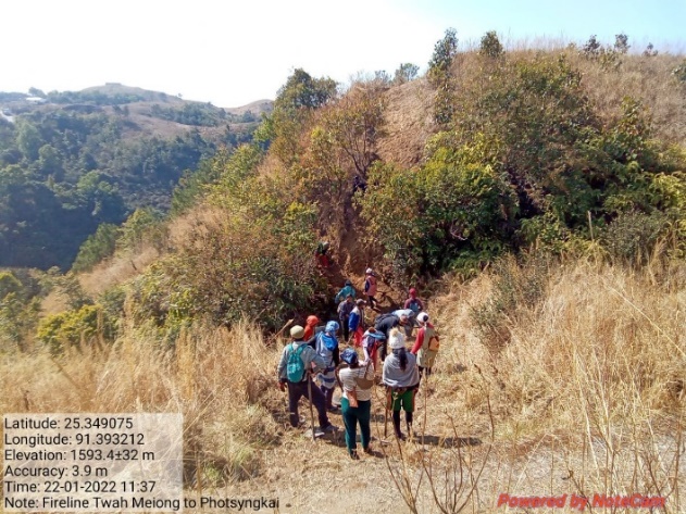
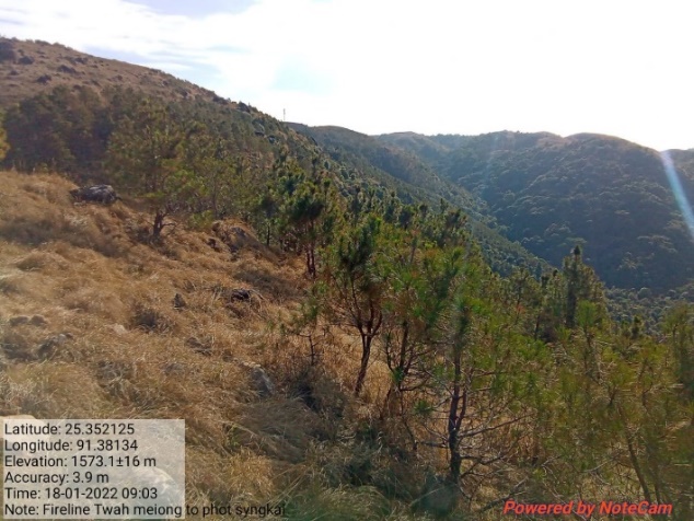
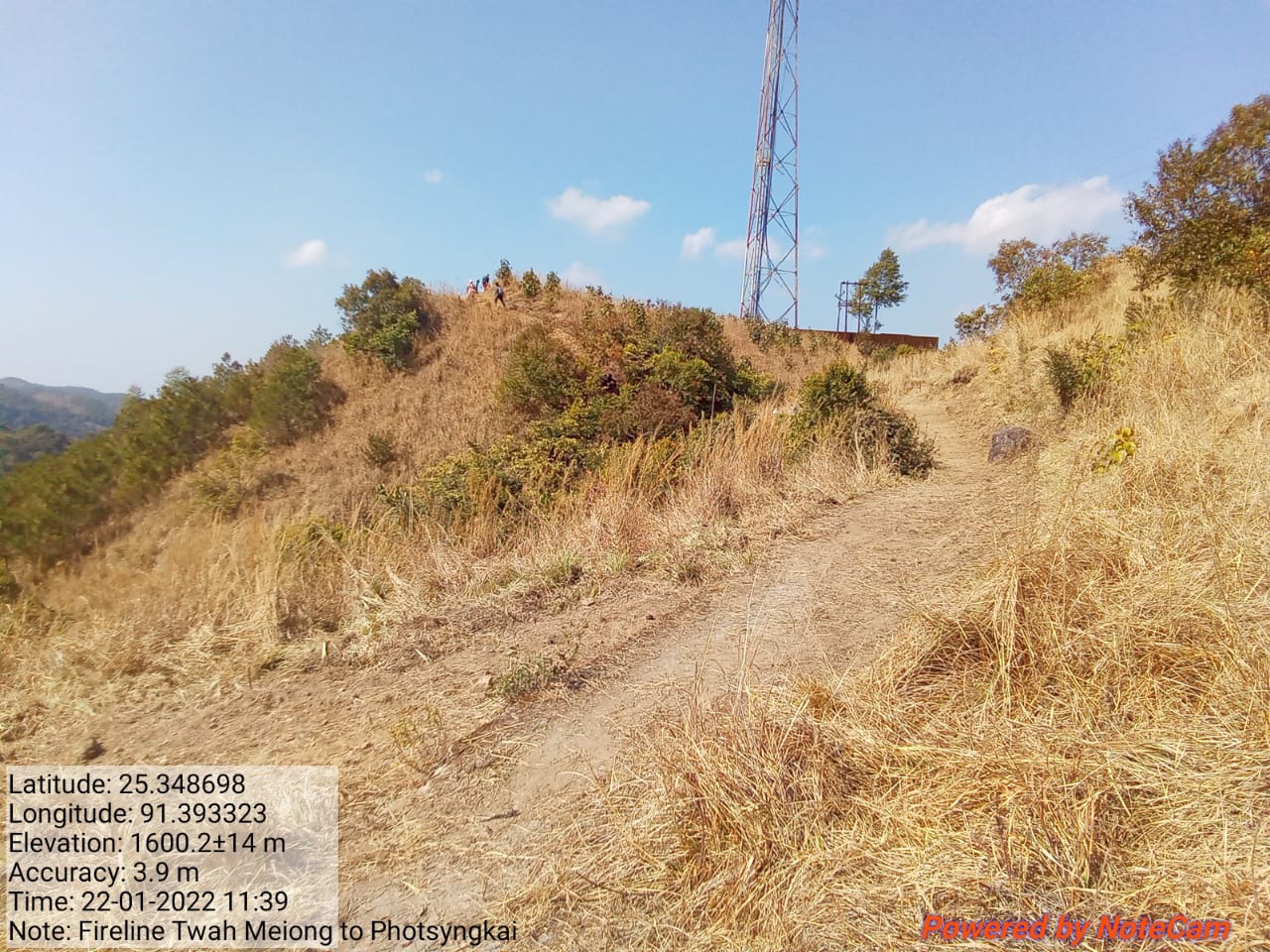
Fig: Fireline from Twah Meiiong to Phot Syngkai.
| 5. | Type Of Intervention | Site Name | GPS Co-ordinates | Amount Sanctioned | Work Status | |
|---|---|---|---|---|---|---|
| Bench Terracing | Domthwekaton | 25.356368 | 91.384893 | Rs.1,42,220 | Ongoing | |
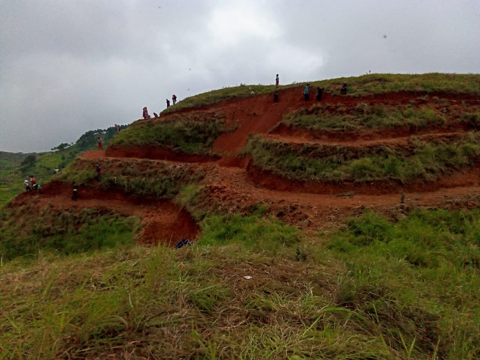
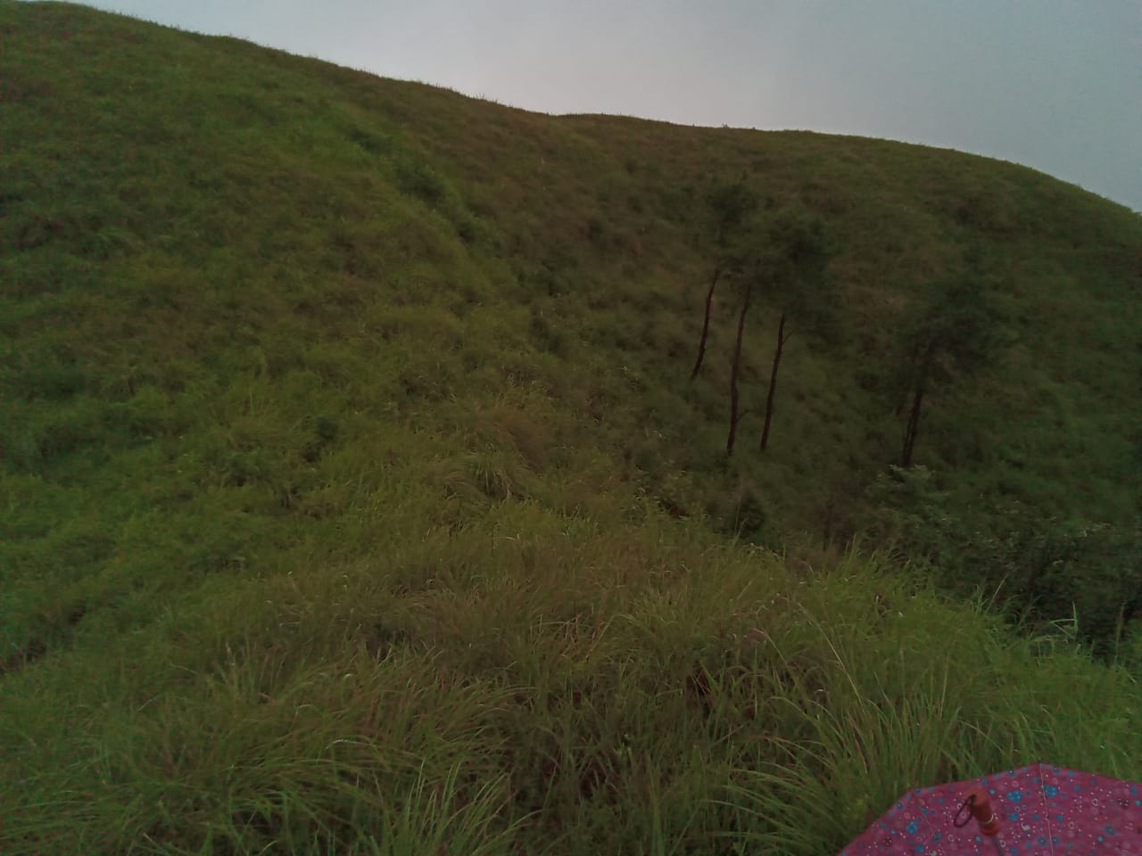
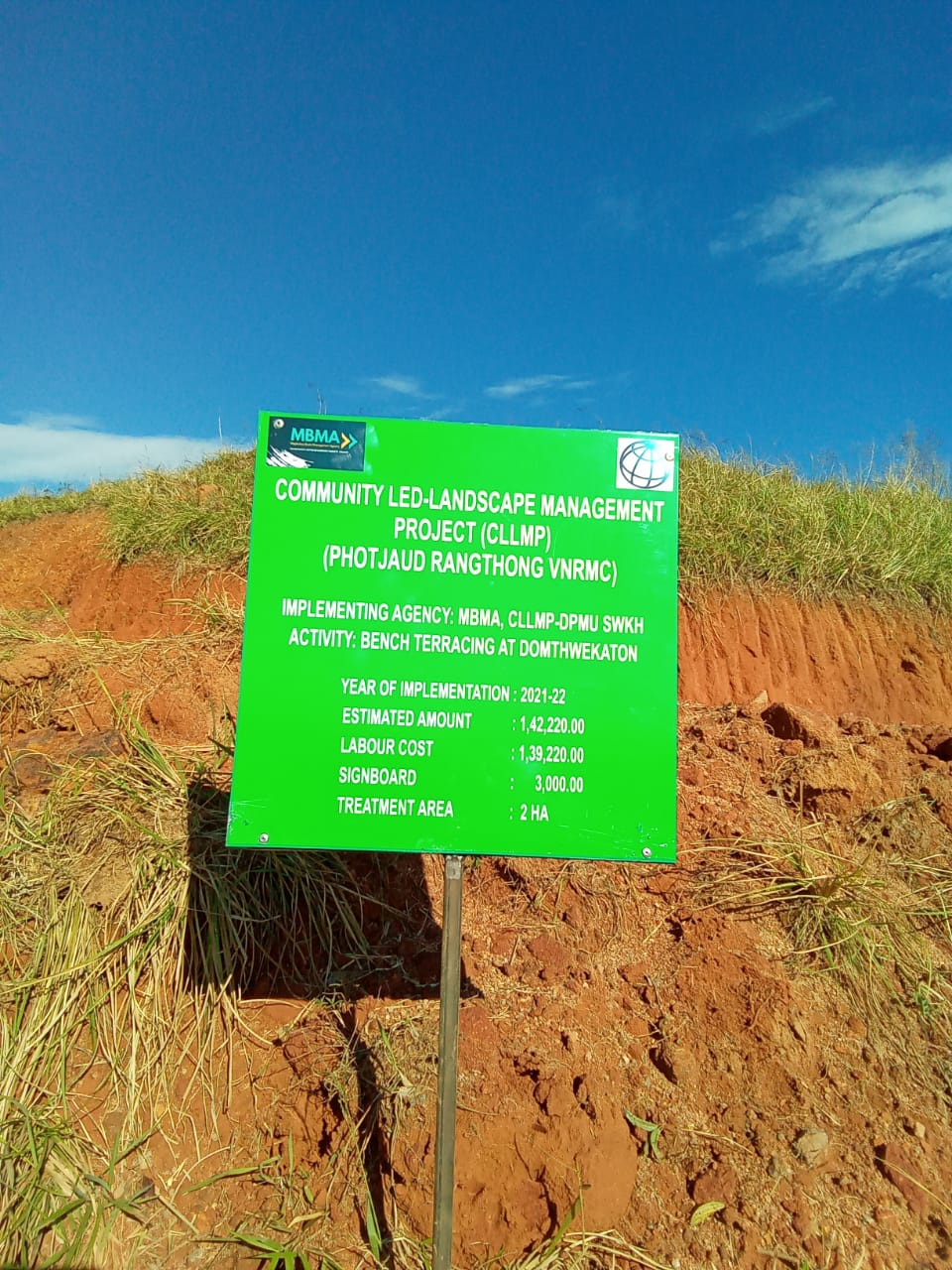
Fig: Bench Terracing at Domthwekaton.
| 6. | Type Of Intervention | Site Name | GPS Co-ordinates | Amount Sanctioned | Work Status | |
|---|---|---|---|---|---|---|
| Bench Terracing | Domnongtwah | 25.358093 | 91.391146 | Rs.72,610 | Completed | |
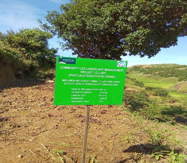
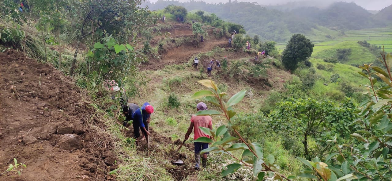
Fig: Bench Terracing at Domnongtwah.
| 7. | Type of intervention | Site name | GPS co-ordinates | Amount sanctioned | Work status | |
|---|---|---|---|---|---|---|
| Community Nursery | Domthwekaton | 25.357636 | 91.385447 | Rs.1,48,640 | Completed | |
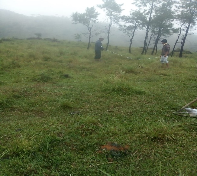
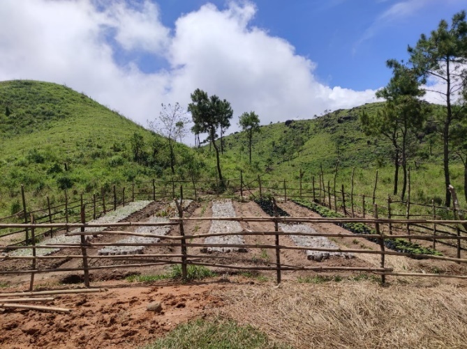

Fig: Community Nursery at Domthwekaton.
| 8. | Type of intervention | Site name | GPS co-ordinates | Amount sanctioned | Work status | |
|---|---|---|---|---|---|---|
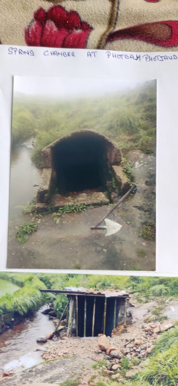
| Spring Chamber & treament of catchment area | Photbah | 25.353359 | 91.389636 | Rs.61,900 | Completed | |

Fig: Spring Chamber and TCA at Photbah.
| 9. | Type of intervention | Site name | GPS co-ordinates | Amount sanctioned | Work status | |
|---|---|---|---|---|---|---|
| Spring Chamber & treatment of catchment area | Jynmu | 25.354827 | 91.39064 | Rs. 65,240 | Complete | |
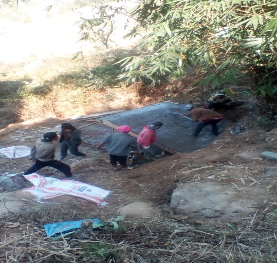
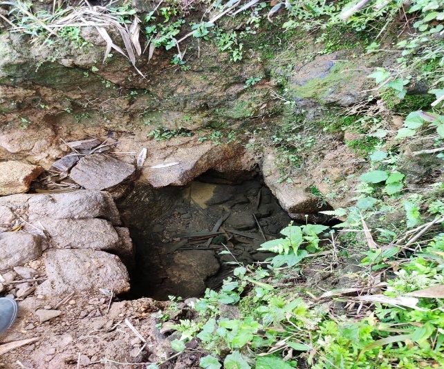
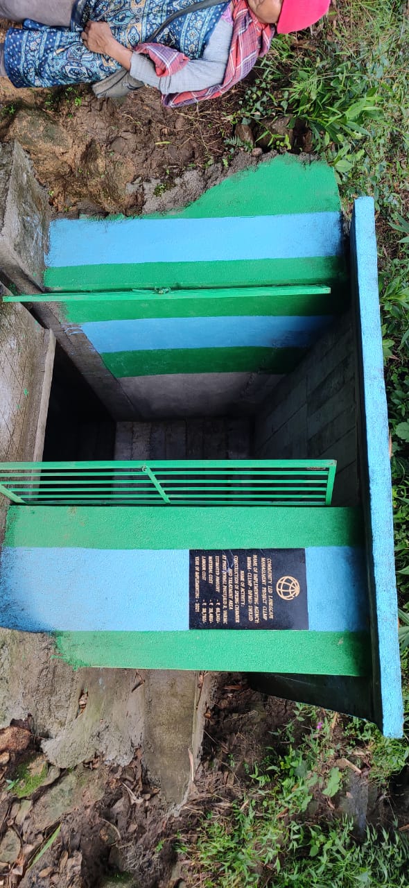
Fig: Spring Chamber and TCA at Jynmu.
| 10. | Type of intervention | Site name | GPS co-ordinates | Amount sanctioned | Work status | |
|---|---|---|---|---|---|---|
| Spring Chamber | Domphotkhniang | 25.356033 | 91.381113 | Rs.52,380 | Complete | |
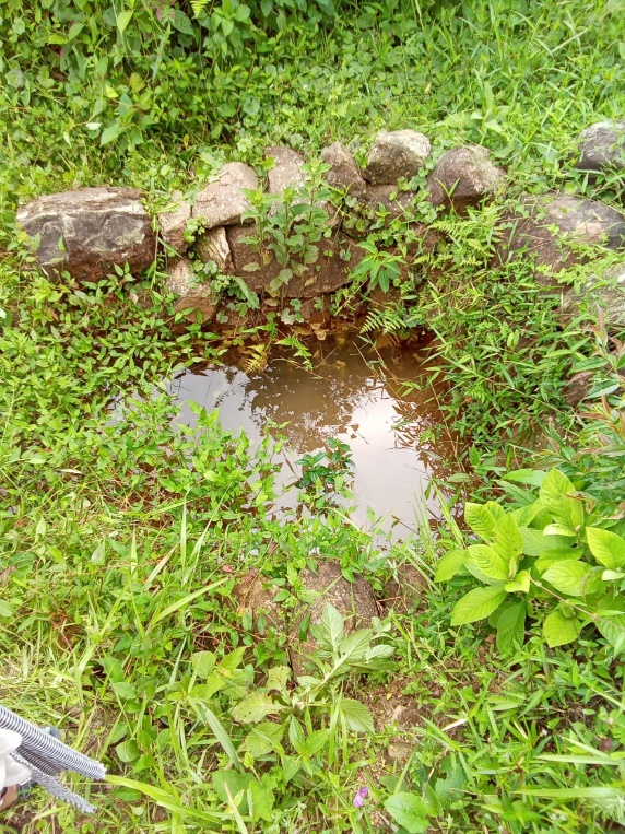
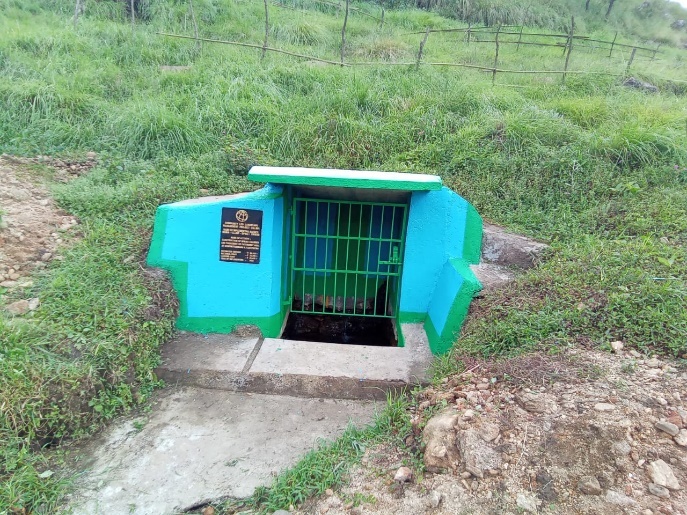
Fig: Spring Chamber at Domphotkhniang
| 11. | Type of intervention | Site name | GPS co-ordinates | Amount sanctioned | Work status | |
|---|---|---|---|---|---|---|
| Fireline | Trawiamrin-Domdisohphoh | 25.361847 | 91.402751 | Rs.1,19,000 | Completed | |
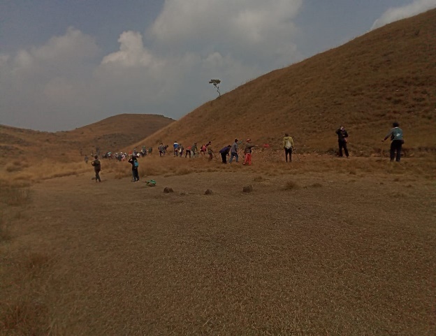
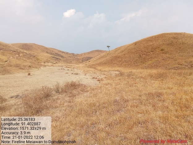
Fig: Fireline from Trawiamrin to Domdisohphoh.
| 12. | Type of intervention | Site name | GPS co-ordinates | Amount sanctioned | Work status | |
|---|---|---|---|---|---|---|
| Gully Plug | Kperkohbor | 25.355691 | 91.387178 | Rs.34,550 | Completed | |
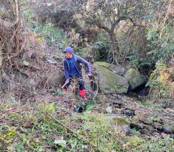
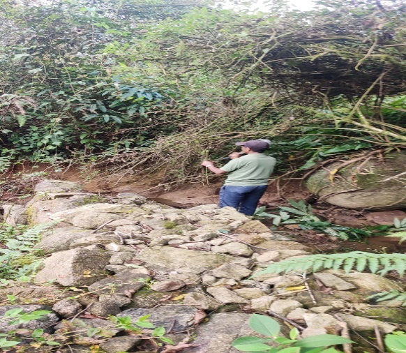
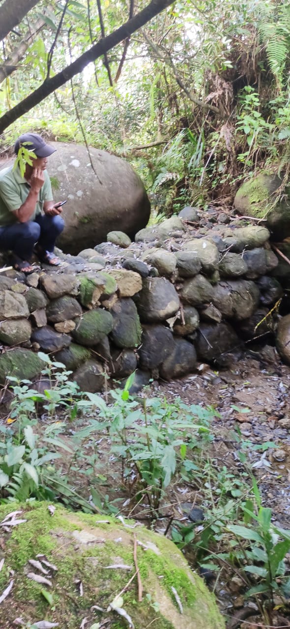
Fig: Gully Plug at Kperkohbor
| 13. | Type of intervention | Site name | GPS co-ordinates | Amount sanctioned | Work status | |
|---|---|---|---|---|---|---|
| Spring Chamber & treament of catchment area | Kyllailamar | 25.352179 | 91.401604 | Rs.55,160 | Completed | |
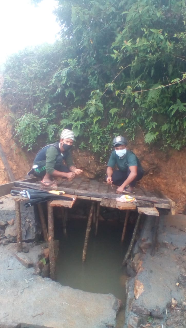
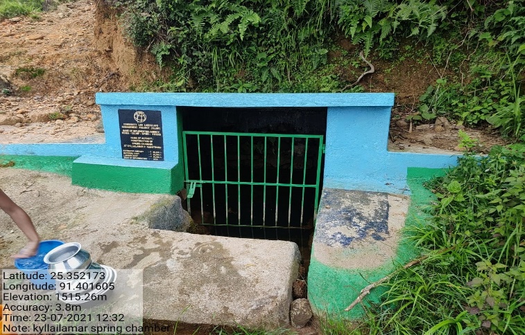
Fig: Spring Chamber and TCA at Kyllai Lamar.
| 14. | Type of intervention | Site name | GPS co-ordinates | Amount sanctioned | Work status | |
|---|---|---|---|---|---|---|
| Spring Chamber | Photburom | 25.352197 | 91.387649 | Rs.70,870 | Completed | |
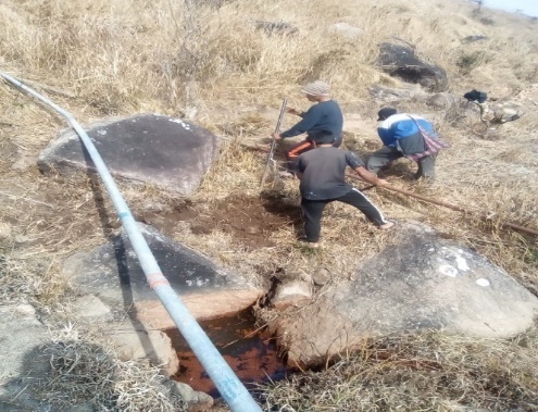
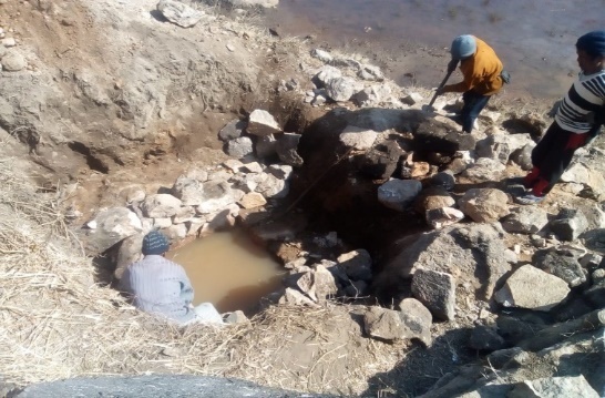
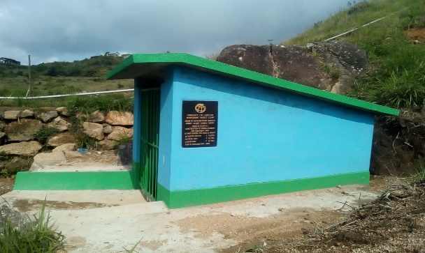
Fig: Spring Chamber at Phot Burom.
| 15. | Type of intervention | Site name | GPS co-ordinates | Amount sanctioned | Work status | |
|---|---|---|---|---|---|---|
| CC Channel | Sdoit photbah | 25.354912 | 91.390183 | Rs.2,18,900 | Completed | |
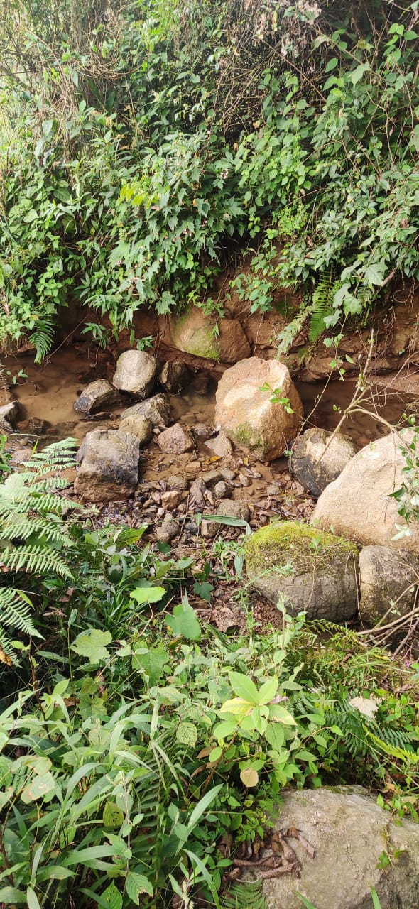
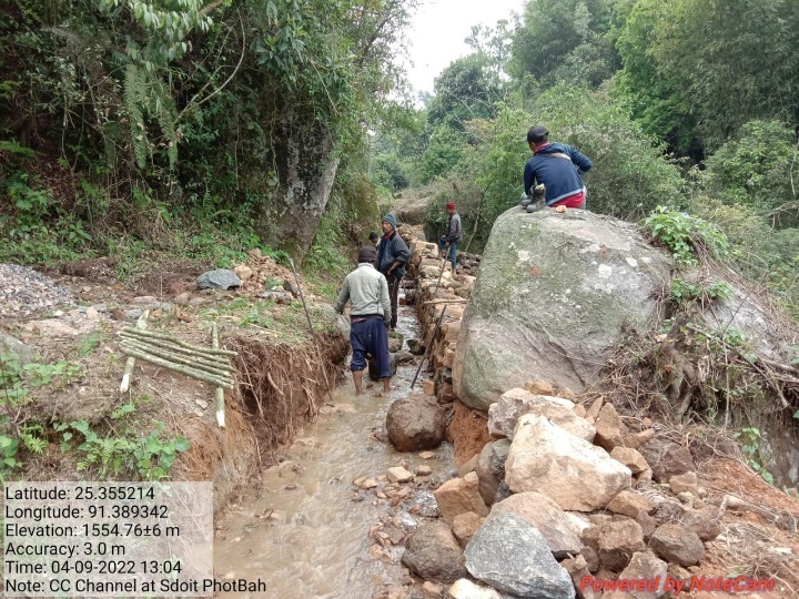
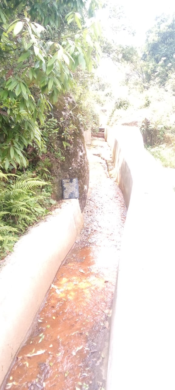
Fig: CC Channel at Sdoit Photbah.
| 16. | Type of intervention | Site name | GPS co-ordinates | Amount sanctioned | Work status | |
|---|---|---|---|---|---|---|
| Agro Horti | Dom Nongtwah | 25.358272 | 91.39141 | Rs.32,440 | Completed | |
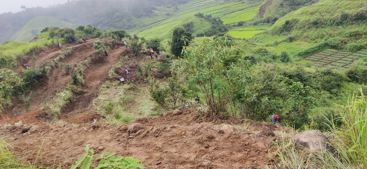
Fig: Agro Horticulture at Dom Nongtwah.
| 17. | Type of intervention | Site name | GPS co-ordinates | Amount sanctioned | Work status | |
|---|---|---|---|---|---|---|
| Fireline | Nongphet to Thwe Aber | 25.355232 | 91.381514 | Rs.1,64,200 | Completed | |
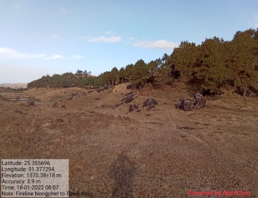
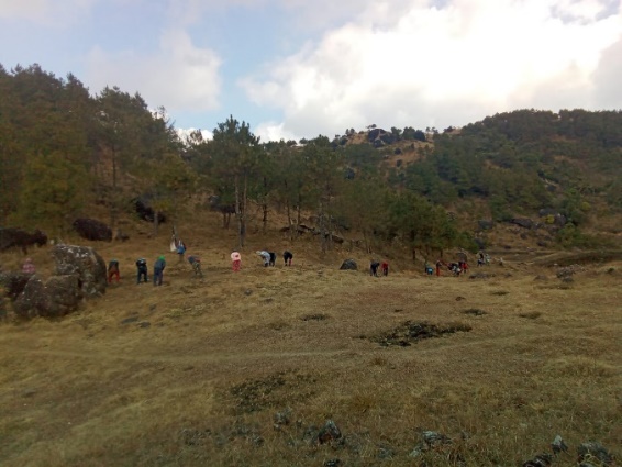
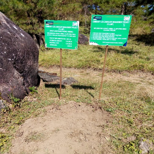
Fig: Fireline from Nongphet to The Aber.
| 18. | Type of intervention | Site name | GPS co-ordinates | Amount sanctioned | Work status | |
|---|---|---|---|---|---|---|
| Agro Forestry | Dom Thwe Katon | 25.356393 | 91.384818 | Rs.58,140 | Completed | |
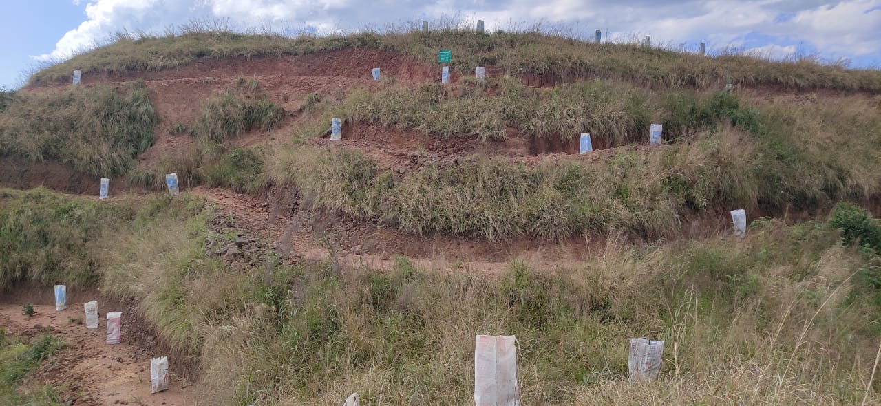
Fig: Agro Forestry at Dom Thwekaton
| 19. | Type of intervention | Site name | GPS co-ordinates | Amount sanctioned | Work status | |
|---|---|---|---|---|---|---|
| Afforestation | Domtiehbah | 25.358112 | 91.385975 | Rs.1,38,000 | Completed | |
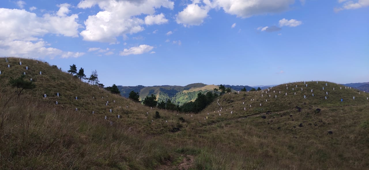
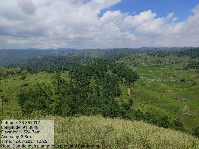
Fig: Afforestation at Domtiehbah
| 20. | Type of intervention | Site name | GPS co-ordinates | Amount sanctioned | Work status | |
|---|---|---|---|---|---|---|
| Afforestation | Dom Kynjang | 25.357638 | 91.385189 | Rs.1,38,000 | Completed | |
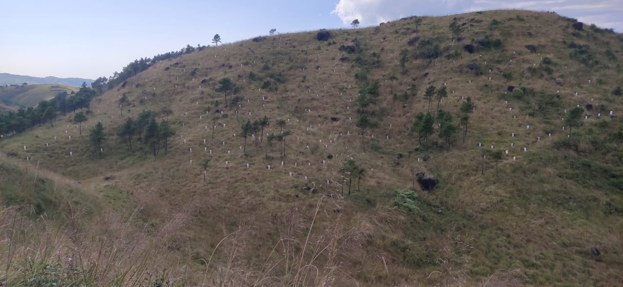
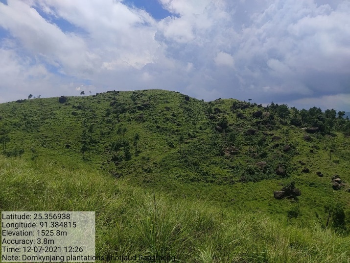
Fig: Afforestation at Dom Kynjang
| 21. | Type of intervention | Site name | GPS co-ordinates | Amount sanctioned | Work status | |
|---|---|---|---|---|---|---|
| Check Dam | Tieh Iaw Iaw | 25.3556 | 91.3918 | Rs.5,00,000 | Completed | |
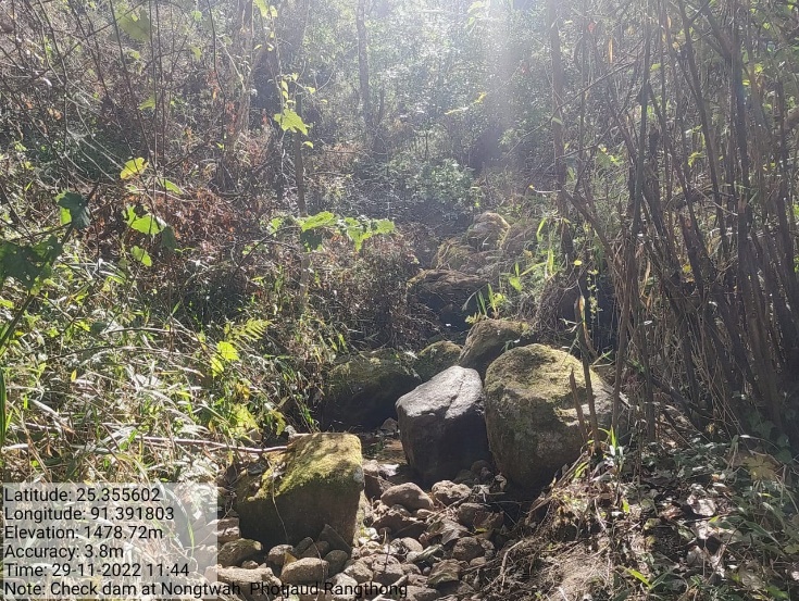
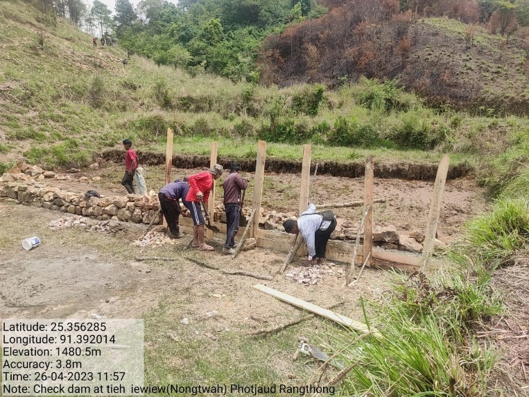
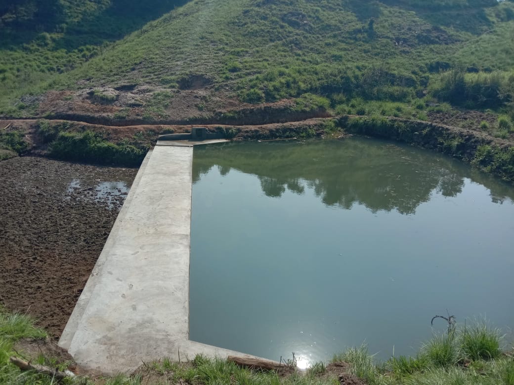
Fig: Check Dam at Tieh Iaw Iaw
11.Fund Status:
Fund Released to VNRMC (Project Implementation)- Rs.26,55,000 Total No. of Work Order Issued- 21 |
|||||
| Activity Name | Amount Sanction | Amount Spent | Work Order Issued Date | Start Date | End Date |
| Check Dam at Thwekaton/Kperkohbor | Rs.4,05,500 | Rs.4,05,500 | 26-Aug-2020 | 13-Dec-20 | 4-Feb-21 |
| Afforestation at Nongrim | Rs.54,750 | Rs.54,750 | 12-Jul-2021 | 24-Jul-21 | 12-Aug-21 |
| Afforestation Treatment of catchment area at Domphotkhniang | Rs.3,500 | Rs.3,500 | 10-Jun-2020 | 15-Jul-20 | 15-Aug-20 |
| Fireline At Twah Meiong-phot Syngkai | Rs.1,19,000 | Rs.1,19,000 | 15-Nov-2021 | 02-Jan-22 | 31-Jan-22 |
| Bench Terracing at Domthwekaton | Rs.1,42,220 | Rs.1,42,220 | 16-Jul-2021 | 02-Jul-21 | 20-Aug-21 |
| Bench Terracing at Domnongtwah | Rs.72,610 | Rs.72,610 | 16-Jul-2021 | 02-Jul-21 | 20-Aug-21 |
| Community Nursery at Domthwekaton | Rs.1,48,640 | Rs.1,48,640 | 25-Feb-2020 | 17-Jun-20 | 30-Sep-20 |
| Spring Chamber & treament of catchment area at Photbah | Rs.61,900 | Rs.61,900 | 8-Jan-2020 | 15-Feb-20 | 20-Oct-20 |
| Spring Chamber & treatment of catchment area at Jynmu | Rs.65,240 | Rs.65,240 | 10-Dec-2020 | 20-Jan-21 | 24-Mar-21 |
| Spring Chamber & Treatment of catchment area at Domphotkhniang | Rs.52,380 | Rs.52,380 | 8-Jan-2020 | 15-Feb-20 | 20-Oct-20 |
| Fireline Trawiamrin-Domdisohphoh | Rs.1,19,000 | Rs.1,19,000 | 14-Dec-2021 | 02-Jan-22 | 31-Jan-22 |
| Gully Plugs, Kperkohbor | Rs.34,550 | Rs.34,550 | 10-Dec-2020 | 20-Jan-21 | 4-Feb-21 |
| Spring Chamber & Treatment of catchment area at Kyllailamar | Rs.55,160 | Rs.55,160 | 8-Jan-2020 | 15-Jun-20 | 20-Oct-20 |
| Spring Chamber at Photburom | Rs.70,870 | Rs.70,870 | 10-Dec-2020 | 20-Jan-21 | 24-Mar-21 |
| CC Channel at Sdoit Photbah | Rs.2,18,900 | Rs.2,18,900 | 25-Feb-2022 | 07-Mar-22 | 26-May-22 |
| Agro Horti at Dom Nongtwah | Rs.32,440 | Rs.32,440 | 28-Mar-2022 | 03-Jun-22 | 30-Aug-22 |
| Fireline From Nongphet to Thwe Aber | Rs.1,64,200 | Rs.1,64,200 | 14-Dec-2021 | 02-Jan-22 | 31-Jan-22 |
| Agro Forestry at Dom Thwe Katon | Rs.58,140 | Rs.58,140 | 28-Mar-2022 | 03-Jun-22 | 19-Jul-22 |
| Afforestation at Domtiehbah | Rs.1,38,000 | Rs.1,38,000 | 28-Mar-2022 | 03-Jun-22 | 19-Jul-22 |
| Afforestation at Dom Kynjang | Rs.1,38,000 | Rs.1,38,000 | 28-Mar-2022 | 03-Jun-22 | 19-Jul-22 |
| Check Dam at Tieh Iaw Iaw | Rs.5,00,000 | Rs.5,00,000 | 6-May-2022 | 06-Feb-23 | 26-May-23 |
12. GROUND TESTIMONIALS:
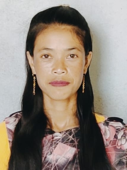
Margret Thongni
VCF Environment Photjaud Rangthong
From this Project I have been benefitted personally as I can test the quality of the water, pH level, water discharge, etc., with the water tracer and fill the information on the Spring Survey App which I do monthly. I also follow up quarterly on the survival rate of all plantation works and as being taught by the Staffs and External experts, I have learned the use of Note Cam App whenever I go for site visitation. Also, I have attended many Trainings conducted by the CLLMP, I feel blessed to have worked with this office that oversees the development and management of the natural resources within the village.
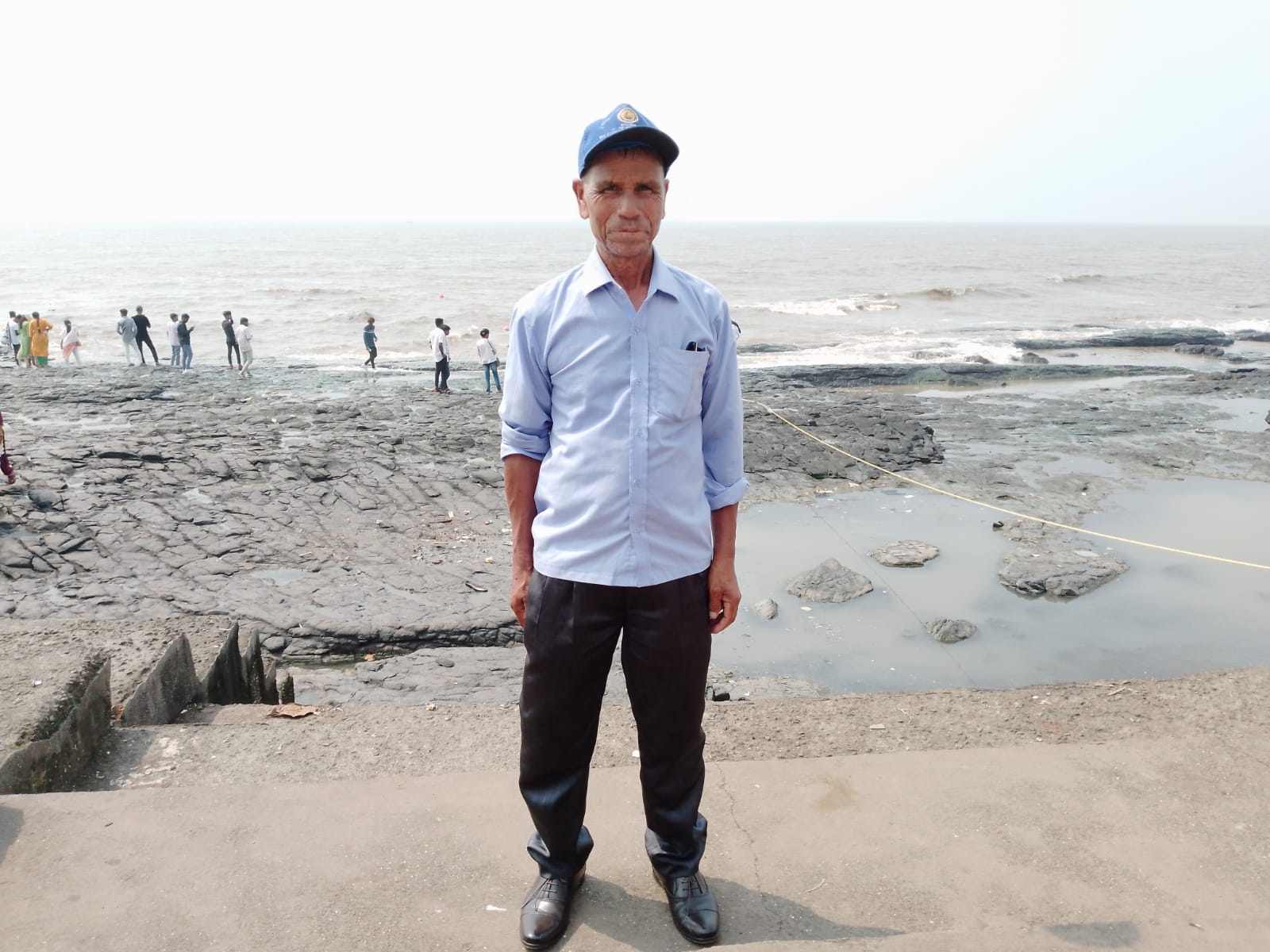
Sirian Thongni
VCF SM & KM Photjaud Rangthong
With the funding from the World Bank, we have seen much changes within our villages in matters relating to the implementation of the various activities aiming at conservation of our natural resources. All activities and intervention received from the office have been benefitted by every resident of our village. Personally, I have attended many trainings conducted by the office which have been very useful to me and these have added to the knowledge of conserving our surroundings
---------------------------------*****************-------------------------------