

COMMUNITY LED LANDSCAPE MANAGEMENT PROJECT (CLLMP)
The Government of Meghalaya with financial help from the World Bank is implementing the Meghalaya Community Led Landscape Management Project (MCLLMP). The project will cover the entire state of Meghalaya and implementation of community led plans will be rolled out in phase manner throughout the state. The Meghalaya Basin Management Agency (MBMA) will facilitate community-led planning by providing support, technical inputs and funding.
The project is intended to strengthen community-led natural resources management in selected landscapes within the 12 districts of the state. This would be achieved through a variety of planning, capacity building, and on-the-ground interventions to promote the conservation, sustainable use of natural resources, social inclusion and community mobilization; building traditional knowledge and learning, mapping of natural resources management; strengthening the community institutions and creating linkage with financial institutions and community organizations.
The project interventions will include preparation of community led natural resource management plans. The CLLMP has the following three components:
Strengthening Knowledge and Capacity of Communities for Natural Resources Management
Community-Led Landscape Planning and Implementation
Project Management and Governance
The project objective is “to manage and conserve the natural resources, especially forests, soil and water sources, in a manner that supports the financial and physical well-being of communities in the State”
The CLLM-Programme focuses on increasing the capacities of communities and traditional institutions (TI) by adopting a landscape approach to manage their natural resources such as soil, springs and other water sources, forests and bio-diversity, etc.
The project will be planned and implemented in about 400 villages across the state.
CLLMP has a strong focus on institution-building at the village-level, by ensuring systematic capacity-building on technical and social skill-sets.
The project will also extend such training to communities beyond the targeted villages and support efforts made by them to access funding from various rural and natural resources initiatives and schemes.
The programme will also invest in improving the process and outcome delivery, by developing and adhering to effective systems and procedures, supported by the appropriate technology.
Benefits for community (Skills and Capacity relating to technical and managerial areas like NRM and Conflict resolution
Benefits to traditional institutions (village councils, traditional leaders, community-based organizations, SHGs etc.) through Knowledge sharing, promotion of innovative approach, access to technology, technical managerial and financial support.
It is estimated that the project will impact around 1 lakh partners (of which 50% are women) who depend on land, forest, agro forestry.
Through the project, 55000 Ha of targeted area will be ensured with availability of water, biological resources and soil productivity, which will in turn benefit around 400 villages and the outcomes delivery can be summarized as follow
The Project will be executed by the MBMA in collaboration with other partners particularly, SIRD (for training and capacity building), Department of Soil and Water Conservation, Water Resource Department, Forest Department, specifically with respect to technical inputs, safeguards management and Community NRM plan preparation
2018-2023 (5 years)
CONTENTS PAGE NO
INTRODUCTION. 5
Brief History About the Village 5-6
Social Profile of The Village 6
Village Accessibility 6
Literacy Rate 6
Population 6
Occupation 7
Fuel Type 7
Card Holding Household 8
Drinking Water 8
Cultivable Land Area 8
Forest Cover 8
Forest Species 8-9
Water Bodies 9
Area Affected 9
CLLMP ACTIVITIES.
GROUND TRUTHING 9
Sensitization Program 10
Signing of EOI, VGA and Green Charter 10
Formation Of the VNRCM 10-11
Village functionaries 11
Village Community Facilitator 12
Procurement Member 12
Opening Of Bank Account 12-13
Participatory Rural Appraisal Exercise 13-17
GIS Activities 17-19
The Proposed List of Intervention 20
Project Implementation 21-30
Fund Status 31-32
GROUND TESTIMONIALS___________________32-33
INTRODUCTION:
 Rangblang ‘A’ village
falls under Mawkyrwat C&RD Block of South West Khasi Hills
District in the state of Meghalaya. The village has a distance of
29kms from Block Headquarter and 30kms from Mawkyrwat, the District
Headquarter. It falls under Nongsohphoh Syiemship with a total
geographical area of 260.27 ha and 414 a total population of
villagers. All the resident of Rangblang ‘A’ village belonged to the
Khasi Scheduled Tribe. The average rainfall of Rangblang ‘A’ village
is 1200mm and the type of soil is loamy.
Rangblang ‘A’ village
falls under Mawkyrwat C&RD Block of South West Khasi Hills
District in the state of Meghalaya. The village has a distance of
29kms from Block Headquarter and 30kms from Mawkyrwat, the District
Headquarter. It falls under Nongsohphoh Syiemship with a total
geographical area of 260.27 ha and 414 a total population of
villagers. All the resident of Rangblang ‘A’ village belonged to the
Khasi Scheduled Tribe. The average rainfall of Rangblang ‘A’ village
is 1200mm and the type of soil is loamy.
BRIEF HISTORY ABOUT RANGBLANG VILLAGE:
Rangblang ‘A’ village falls under the supervision of the Hima Nongsohphoh Syiemship, which is under the district of South West khasi Hills. In the year 1985 the village of Rangblang ‘A’ was identified by the office of Syiem Nongsohphoh through Summer Syiemiong who is the leader king at that time the first headman of the village was Patrict Iawphniaw who had passed away. In over 37 years, they have had over 6 Headmans in the village of Rangblang ‘A’. The Headman of Rangblang ‘A’ has their own way to operate or manage the government scheme within the village. Till now, the village has progress together with the hardwork of different commitee such VEC, VWSC, VNRMC and other commitee together with the notice of the Excecutive Committee of the village.
SOCIAL PROFILE OF RANGBLANG ‘A’ VILLAGE:
The Dorbar serves as the traditional form of local governance in the village where the head is the Rangbah Shnong that look after the administration, safety of villagers as well as overall governance. Apart from the village Dorbar, there is also the Rangblang ‘A’ VEC that oversees the implementation of Mahatma Gandhi National Rural Employment Guarantee Act and other developmental works and the recently formed VNRMC and the World Bank aided CLLMP respectively.
Village Accessibility: In order to reach Rangblang ‘A’ village one must travel through Mawkyrwat PWD road towards the way to Nongstoin near Rangblang sohsyniang village.
Literacy Rate: According to the census 2011, Rangblang ‘A’ village has higher literacy rate compare to the state. Rangblang ‘A’ village literacy rate was 87.16% compared to 74.43% of the state. In Rangblang ‘A’ Male literacy rate stands at 85.59%, while Female literacy rate was 88.79%.
Population: As per Census 2011, Rangblang ‘A’ village has a total population of 267 of which 142 are males while 125 are females. But, in the recent year survey the total of population has increased to 414 peoples. Out of this 202 are males, while 212 are females. The village has 55 children in the age group of 0-4 years. Among them 30 are boys and 25 are girls.
| Age Groups | Male | Female | Total |
|---|---|---|---|
| 0-4 | 30 | 25 | 55 |
| 5-14 | 34 | 30 | 64 |
| 15-30 | 40 | 45 | 85 |
| 30-60 | 50 | 60 | 110 |
| Above 60 | 48 | 52 | 100 |
Occupation: The people of the village rely mainly on agriculture and forest products for their livelihood. The main occupation of the villagers is farming followed by teaching some other are engaged in government service and in business.
Fuel Type: In Rangblang ‘A’ village peoples they are mainly uses only wood as their fuel. About 62 households depend on wood gathered from the forest for their daily requirement.
| Fuel Types | No of Households | Quantity (Kg/HH) | Total |
|---|---|---|---|
| Wood | 62 | 6000 Kg (1 year) | 210000Kg |
| Particulars | No. of Households |
|---|---|
| Ration Card | 52 |
| Health Card | 62 |
Card Holding Households:
Drinking Water: The people of Rangblang ‘A’ have access to drinking water mainly from the 7 springs that are within the village which are all perennial. Government water supply lines are also available in this village. But over the years there has been a scarcity of water supply especially during the month of November to April due to less water discharge from the spring sources and due to the increase in human population and their daily requirements.
Cultivable Land Area: The type of soil in Rangblang ‘A’ village is loamy soil. The people in this village they use to plant crops like potato, sweet potato, beans, maize, rice, carrot, radish, cauliflower, cabbage, and squash. They also cultivate berry, lemon, myrica esculenta (soh phie), peach, sohambura(grapefruit) and wild pear.
Forest Cover: The total forest covers under Rangblang ‘A’ village is 46.78 ha. There are many private forests within the village and the quality of these forest ranges from moderate to open. There are also 4 numbers of clan forests, that are from the clan Laikynja, Thyrniang, Iawphniaw and Jahkit and these forests are dense in quality. People use the forest products mainly for fuel wood, timber, medicines, and aromatic plants and for other purposes.
Forest Species: Some of the indigenous tree species found in this village are Diengngan, Diengstap, Diengwain, Diengloin, Diengkseh, Diengtyrpei, Diengthot, Diengtemrilang, Diengsohlang, Diengsohmian, Diengsong, Diengsohphlut, Diengsnammaw, Diengsohrynmehblang, Diengsohpian, Diengsohkyiut, Diengtohtiehiong, Dienglymba, Diengsohot. There are some other valuable medicinal trees and valuable grasses used by the people of the community for medicinal purposes like Sohshang, Sohtyngkhur, Sohiong, Sohphie, Sohbrab, Tewlamut, Sohprewiong, sohprewsaw, Sohpdah, SohphyrwiaJhur: Jamyrdoh, Jalem, Jatira, Batnepbrew, Batjajew, Jalei. These forests are also a home of some endangered fauna that are found in Rangblang ‘A’ village like Clouded Leopard, Porcupine, Rabbit, fox, phyllat, peilang, khlakhnai.
Water Bodies: Total area of water bodies in Rangblang ‘A’ is 7.71 ha. There are seven springs within the village which people use mainly for drinking purpose. There are some streams within the village geographical area which are perennial and are mainly use for washing, irrigation and fisheries and one river namely, Wahjyrhap that flow under Rangblang ‘A’ geographical area which people uses for sand minning.
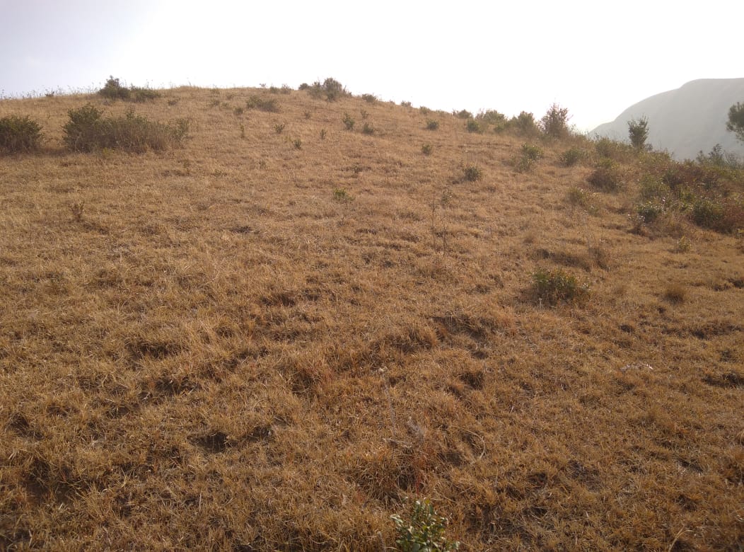
Area Affected: In Rangblang ‘A’ village about 13.75 ha of land have been degraded over the years. Approximately 21.7 ha are due to soil erosion, forest fires, excessive felling of trees and Jhum cultivation which have led to the loss of productivity of the land and the loss of the saplings and other natural resources. About 2.92 ha of cultivable land have been affected by the excessive use of fertilizers and 10.13 ha of land have been degraded over the years owing to human settlement, water bodies and culturable wastelands.
CLLMP ACTIVITIES.
GROUND TRUTHING: The CLLMP officials met with Mr. Gracianus Thyrniang Headman of Rangblang ‘A’ village, Mr. Ferdinand Khardewsaw the village Secretary and other village representatives for field assessment. Mr. Thyrniang, provided the CLLMP Team with important information regarding the current scenario of the landscape and the natural resource management under his headmanship
Case Findings:
Most of the household falls under the BPL category.
They have an actively performing VEC in the village.
The land within the village falls under the Nongsohphoh Syiemship.
The source of water supply in the village is from two sources: private and public.
There are a few patches of degraded land that has been left unused.
There is a loss of Natural Vegetation in the area.
SENSITIZATION PROGRAM: The District Project Manager Mr. J Wanniang along with the staff held a village Level Sensitization Programme on the Community Led Landscape Management Project (CLLMP) on the 5th February, 2020. The villagers actively participated in the program, voicing out their concerns and questions regarding the project making it a huge success.
Highlights of the meeting:
Awareness about the Community Led Landscape Management Project (CLLMP).
Laying the importance on the involvement of the community in making the CNRM plan and its success.
A brief awareness on cleanliness was conducted based on our finding during the ground truthing phase.
An interactive session was held to answer doubts of the villagers regarding the project.
SIGNING OF EOI, VGA AND GREEN CHARTER: On 14th February, 2020 Rangblang ‘A’ village signed the EOI (Expression of Interest), VGA (Village Grant Agreement) and the Green Charter after there was a uniform agreement by the people of the entire Community that the Community Led Landscape Management Project (CLLMP) be implemented at Rangblang ‘A’ village.
FORMATION OF THE VNRCM: The formation of the Village Natural Resources Management Committee was done in a public meeting on the 5th February, 2020 in the presence of the entire village and the CLLMP Staff. The people of the community chose the President, The Secretary, the Purchase Committee members and the other Executive members to formed the Rangblang ‘A’ VNRMC. There are 9 Executive members, 3 Village community Facilitator and 3 Purchase Committee Members.
List below are the members of the VNRMC:
| Sl. No | Name in Full | Gender M/F | Age (in Yrs) | Education | Designation | Occupation | Community | Contact No and Email Address |
|---|---|---|---|---|---|---|---|---|
| 1 | Gracianus Thyrniang | M | 32 | B.Teach | President | Teacher | Khasi | 8837319054 |
| 2 | Carida Thyrniang | F | 39 | BA | Secretary | Teacher | Khasi | 6009579348 |
| 3 | Euginia Thyrniang | F | 30 | M.A | Finance Secretary | Teacher | Khasi | 9366410968 |
| 4 | Heribeth Thyrniang | M | 56 | IV | Member | Farmer | Khasi | 9366756961 |
| 5 | Emilda Thyrniang | F | 30 | BA | Member | Farmer | Khasi | NA |
| 6 | Bethwell Nadon | M | 35 | XII | Member | Teacher | Khasi | 8787839960 |
| 7 | Genes Sangriang | M | 40 | III | Member | Farmer | Khasi | NA |
| 8 | Joysline Thyrniang | F | 34 | X | Member | Farmer | Khasi | 9863980996 |
| 9 | Shemphang Nonglang | M | 35 | BA | Member | Teacher | Khasi | 9366022979 |
4.1 VILLAGE FUNCTIONARIES:
| Sl. No | Name In Full | Gender M/F | Age (In Yrs) | Education | Designation | Occupation | Community | Contact No and Email Address |
|---|---|---|---|---|---|---|---|---|
| 1 | Gracianus Thyrniang | M | 32 | B. Teach | Village Headman | Teacher | Khasi | 8837319054 |
| 2 | Ferdinand Khardewsaw | M | 41 | IX | Secretary | Farmer | Khasi | 9366432083 |
| 3 | Carlus Shangpliang | M | 30 | IX | Finance Secretary | Self-Employment | Khasi | 8787558401 |
| 4 | Faustine Thyrniang | M | 53 | XII | Vice- Chairman | Farmer | Khasi | NA |
| 5 | Bhabiang Sanriang | M | 43 | X | Assistant Secretary | Self-Employment | Khasi | NA |
| 6 | Albinus Myrthong | M | 58 | M.A | Adviser | Farmer | Khasi | NA |
| 7 | Heribet Thyrniang | M | 50 | IV | Member | Teacher | Khasi | 9366756961 |
| 8 | Richard Dkhar | M | 55 | VIII | Member | Farmer | Khasi | NA |
| 9 | Delphin Thyrniang | M | 48 | X | Member | Farmer | Khasi | NA |
| 10 | Gipling Sangriang | M | 47 | II | Member | Farmer | Khasi | NA |
| 11 | Amos Thyrniang | M | 50 | IV | Member | Farmer | Khasi | NA |
4.3. VILLAGE COMMUNITY FACILITATOR:
| Sl. No | Name | Gender M/F | Age (in Yrs) | Education | Role | Contact No and email address |
|---|---|---|---|---|---|---|
| 1 | Jamespaul Iawphniaw | M | 30 | IX | Environment & GIS | 8787558401 |
| 2 | Sylvanus Thyrniang | M | 26 | BA | Social & KM | 9366723229 |
| 3 | Carida Thyrniang | F | 41 | XII | ME & PM | 6009579348 |

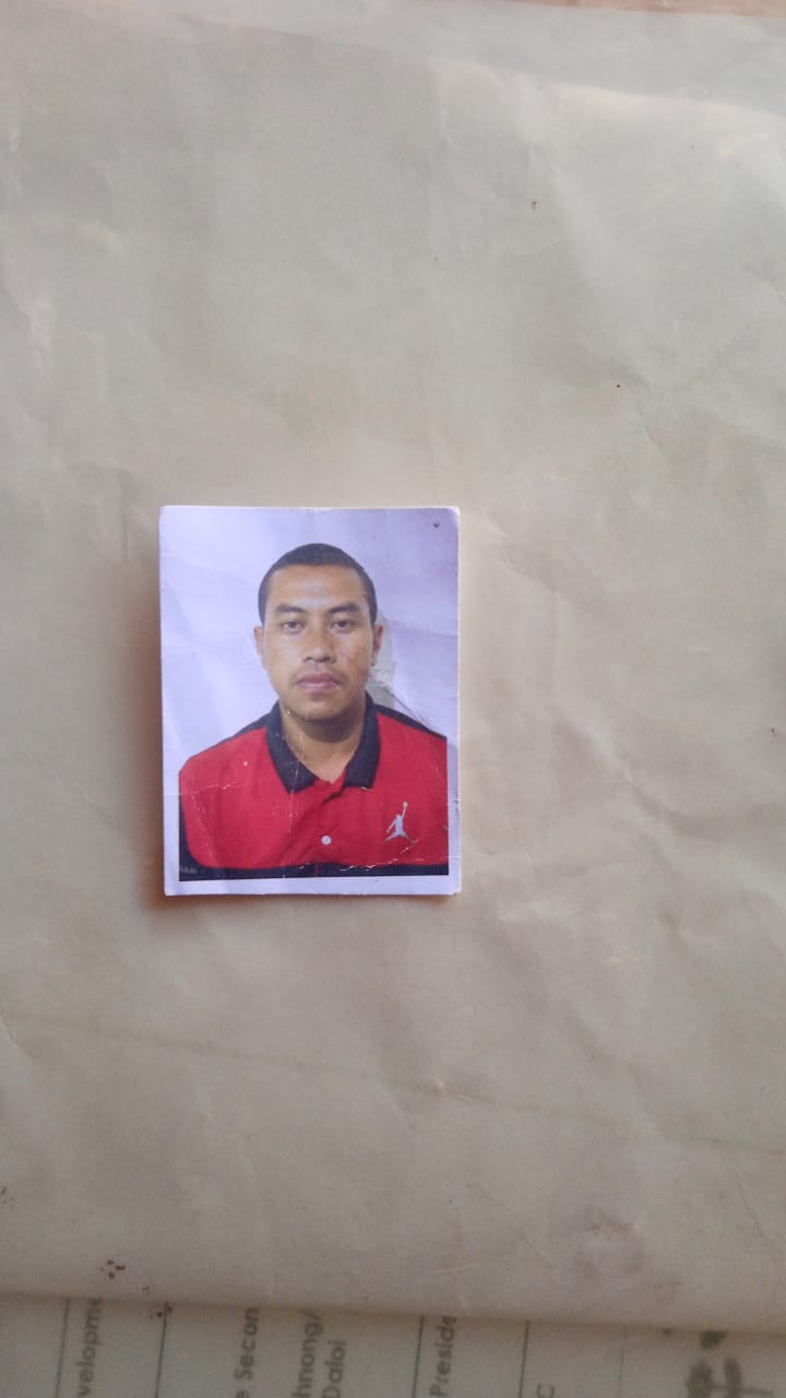
Figure: Village Community Facilator of Rangblang ‘A’village.
4.4. PROCUREMENT MEMBERS:
| Sl no. | Name | Age | Gender | Qualification | Contact Number |
|---|---|---|---|---|---|
| 1. | Ferdinand Khardewsaw | 41 | Male | IX | 9366432083 |
| 2. | Faustine Thyrniang | 53 | Male | XII | 9366884050 |
| 3. | Liliana Thyrniang | 45 | Female | XII | 9863431110 |
OPENING OF BANK ACCOUNT: The opening of the bank account was done after the signing of the EOI (Expression of Interest), the VGA (Village Grant Agreement) and the signing of the Green Charter. The Accountant of CLLMP South West Khasi Hills trained the Purchasing and Procurement Committee of Rangblang ‘A’ village on matters relating to Accounts and Book Keeping and on the:
Principles of Community Procurement
Benefits of Community Procurement
Important aspects undertaken by Community Procurement.
Procurement Process/Steps
Function of Purchase Committee
Important Procurement records to be maintained
Financial limits and methods
Maintaining of Books of Accounts to the Book Keeper.
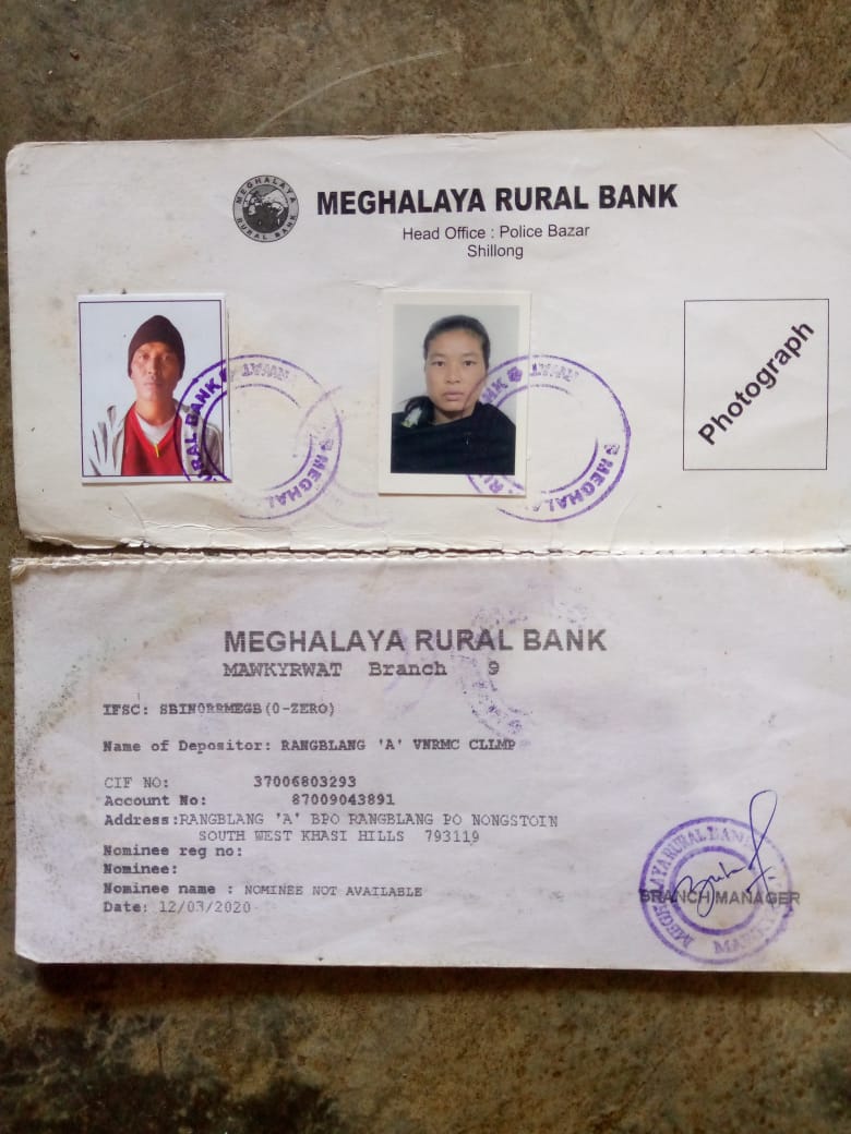
Figure: Details Bank Account of Rangblang ‘A’ village.
PARTICIPATORY RURAL APPRAISAL EXERCISE: The PRA exercise aims to incorporate the knowledge and opinions of the community in the planning and management of development projects and programmes.
The PRA exercise took place on the 5th February, 2020 and the villagers took part in this exercise and also contributed their time and knowledge to this project.
The District Project Manager gave the introduction and spoke about the different activities that the participants had to take part in the programme.
The Program Associate, Environment Management, spoke about the different CNRM plans and the different types of intervention. A group of participants interacted and helped in the collection of data based on the environmental template. With the help of this group, different sites of interventions were identified, analysed and evaluated in order to prioritized the areas that needed the natural resources management.
The Assistant Manager, Social Management, gathered the remaining group of participants to gather the baseline data bases on the social template.
The main objectives of PRA exercise is:
To identify the natural, human and economic resources of the village.
To identify the village problems and prioritized them with the help of the community members.
To prepare the community natural resources management plan of the village.
Findings based on the information gathered from the participants during the PRA/CNRMP exercise:
The main agro-horticultural produce is sweet potato, potato, maize, squach, rice, sohphoh phareng, sohphoh, sohphie and plum.
Most of the household depend on firewood as a source of fuel.
Drinking water is limited over a period of 3-4 months during the winter season.
There are two types of forest ownership: private and clan forest.
The springs which are present in the village needs rejuvenation.
Training on Land productivity, Spring shed management and Community nursery is necessary for the village community.
There are no disputes/constraints encountered within the village community or with any neighbouring villages.
Priorities Intervention required based on the PRA Exercise:
Rejuvenation of the Springs within the community through activities such as afforestation, treatment of catchment areas and contour trenches.
Afforestation, Bio-fencing and fire line control in the community forest.
Community Nursery for endemic trees.
Water storage tanks for collecting rain water.
Check dams for erosion control.
Afforestation and Roadside plantation.
Culturable wastelands to be brought under horticulture.
Baseline Data Survey to fill the Environment and Social Template:
During the PRA Exercise the External Expert of Social & Environment Management held a group discussion with the different groups to gather basic village information regarding number of households, demographic information, major crops and enterprises taken in the village, trends of production and productivity of major crops in the village and demographic distribution of village population.
Information related to land use category such as forest, cultivable land, water bodies, etc and the problems and challenges related to NRM were discussed.
Focused Group Discussion on Problem Analysis:
Do people have sufficient access to supply of fodder, fuel wood, leaf litter?
No, people in the village do not have sufficient access to supply of fodder, fuel wood, leaf litter.
Has access to timber improved or reduced over the years? How is access for household use and commercial use managed?
Access to Timber has reduced over the years. People have to purchase it from neighbouring village and market when needed.
Are the water bodies facing any threats?
Some of the water bodies within the village have faced minor threats.
Do all people in the village have access to drinking water? What are the challenges?
Yes, there is sufficient drinking water in the village except during the winter season due to less discharge of water from the spring source.
Are there degraded areas in the village (open/ degraded forests, mining affected, high soil erosion etc.)?
There are some minor degradations in cultivated land.
What has caused this degradation? Are there practices causing threats to availability and access to natural resources?
Fertility of the soil has decline over the year.
The practices that cause threat to the availability of these resources are:
Fires that take place every year
Excessive practice of Jhum Cultivation
What have been the changes in agricultural practices?
Previously their method of farming is Shifting Cultivation, but over the years with much awareness people have now direct to more conservation practises in order to recover the forest.
Are there any challenges in farming?
The main challenge faced by the people of Rangblang A village is that over the years they have seen a decline in the soil productivity due to soil erosion.
How would you consider the health situation in your village?
The village has a nearest health care facility which 25km away from the village.
How is the situation of cleanliness, sanitation, access to toilets and waste management?
Sufficient toilets are available in every household but most of the constructions are poor. The presence of VWSC in the village has also improve sanitation and cleanliness. But Waste Management is poor because people are not really aware of how to properly disposed off waste.
Who are the most vulnerable in the village? What can be done to improve their lives?
BPL Families. Inclusion of BPL family members during project implementation
What are the livelihood aspirations of the youth? Are there any avenues available?
None, except daily wages labourers.
Do any committees/ institutions/ rules exist to manage and monitor natural resources in the village?
The VNRMC under the CLLMP is the main committee that is now in place to manage the natural resources in the village.
What are some of the major issues of conflict in the village?
Nothing related to NRM.
M. Have any of the above issues been discussed in village meetings?
Yes.
How do people resolve disagreements and conflicts?
All disagreements and conflicts are addressed by the traditional institution of village called the Village Dorbar.
Village Boundary Mapping and Recourse Mapping:
The GIS personnel along with the Village Community Facilitators mapped the village boundary of Rangblang ‘A’ village.
The village resource map is prepared by the people of the community. Recourses such as agricultural lands, wells, wastelands, cattle population, playgrounds, ICDS, churches, community halls, etc were mapped.
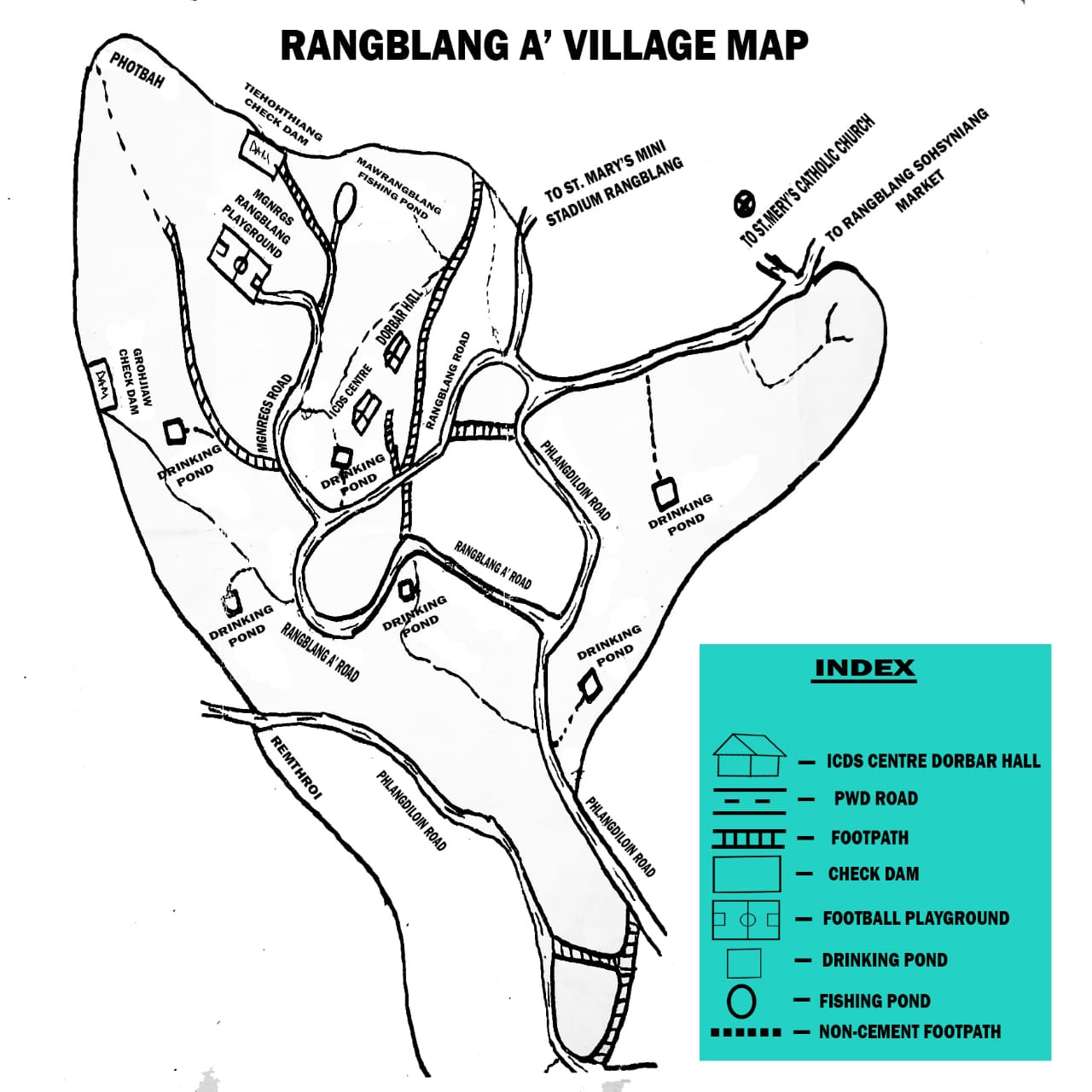
Figure: Resource Map of Rangblang ‘A’ village.
GIS ACTIVITIES:
| Sl. No. | Parameters | Village Information |
|---|---|---|
| 1. | GPS Coordinates: | |
| I | Latitude | 25.415575 |
| II | Longitude | 91.355659 |
| III | Elevation Reading (MSL) | 1528mm |
| 2. | Village Geographical Area (Ha) | 260.27ha |
| I | Total Forest Area (including community, Clan, Pvt Forest) | 46.78ha |
| II | Total Area of Water Bodies | 17.71ha |
| III | Total Area under Agri-Horticulture | 41.71 |
| IV | Total Degraded land area (Ha) | 34.8 ha |
| 3. | Average Annual Rainfall | 1200mm |
| 4. | Soil Type | Loamy soil |
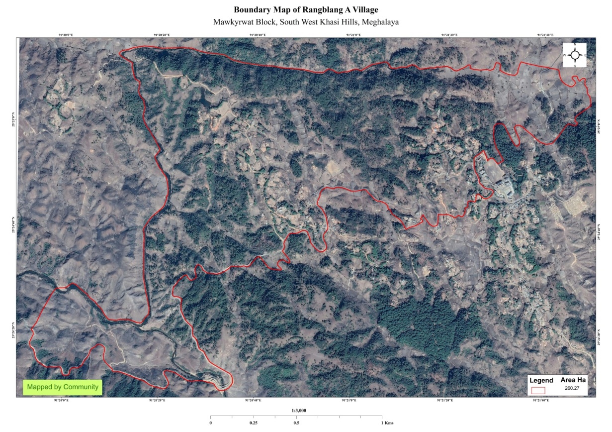
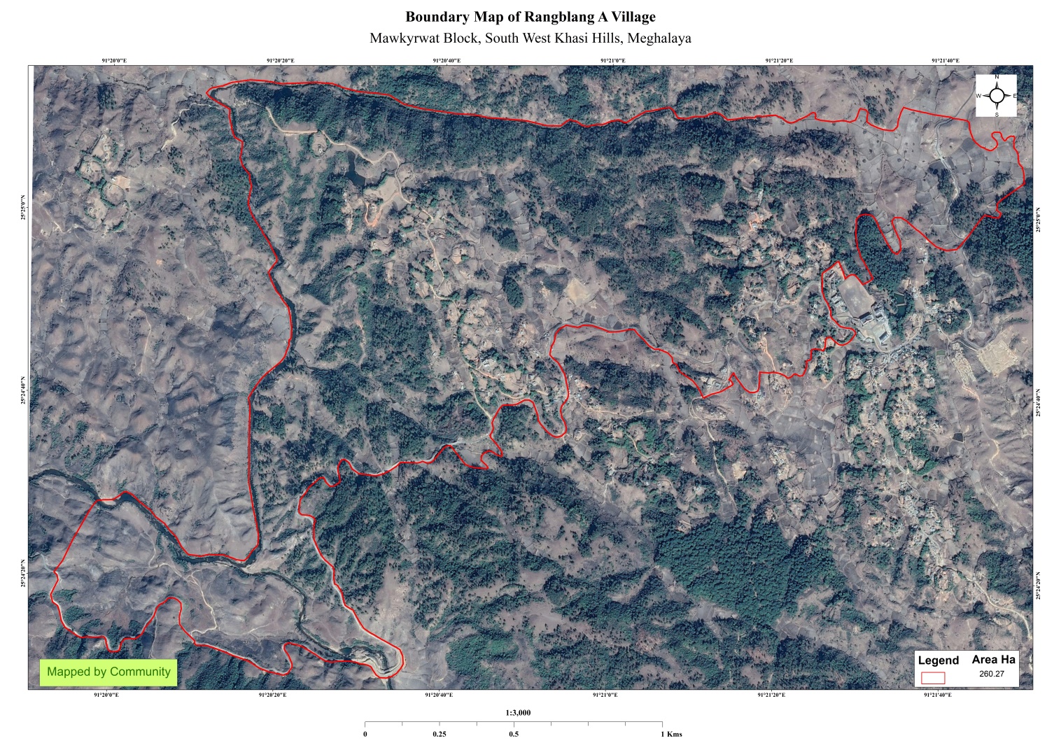
Figure: Village boundary map of Rangblang ‘A ‘ village.
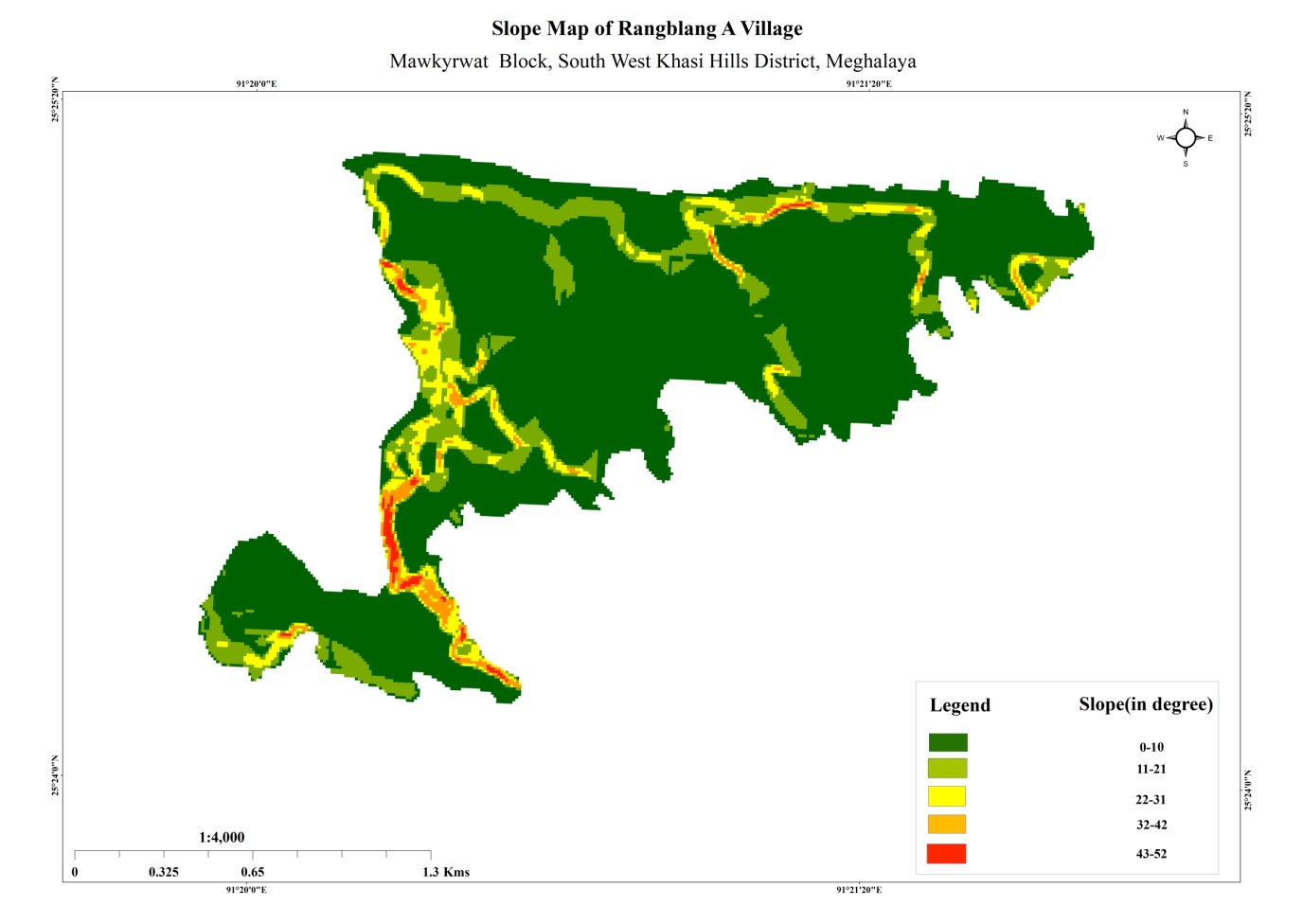
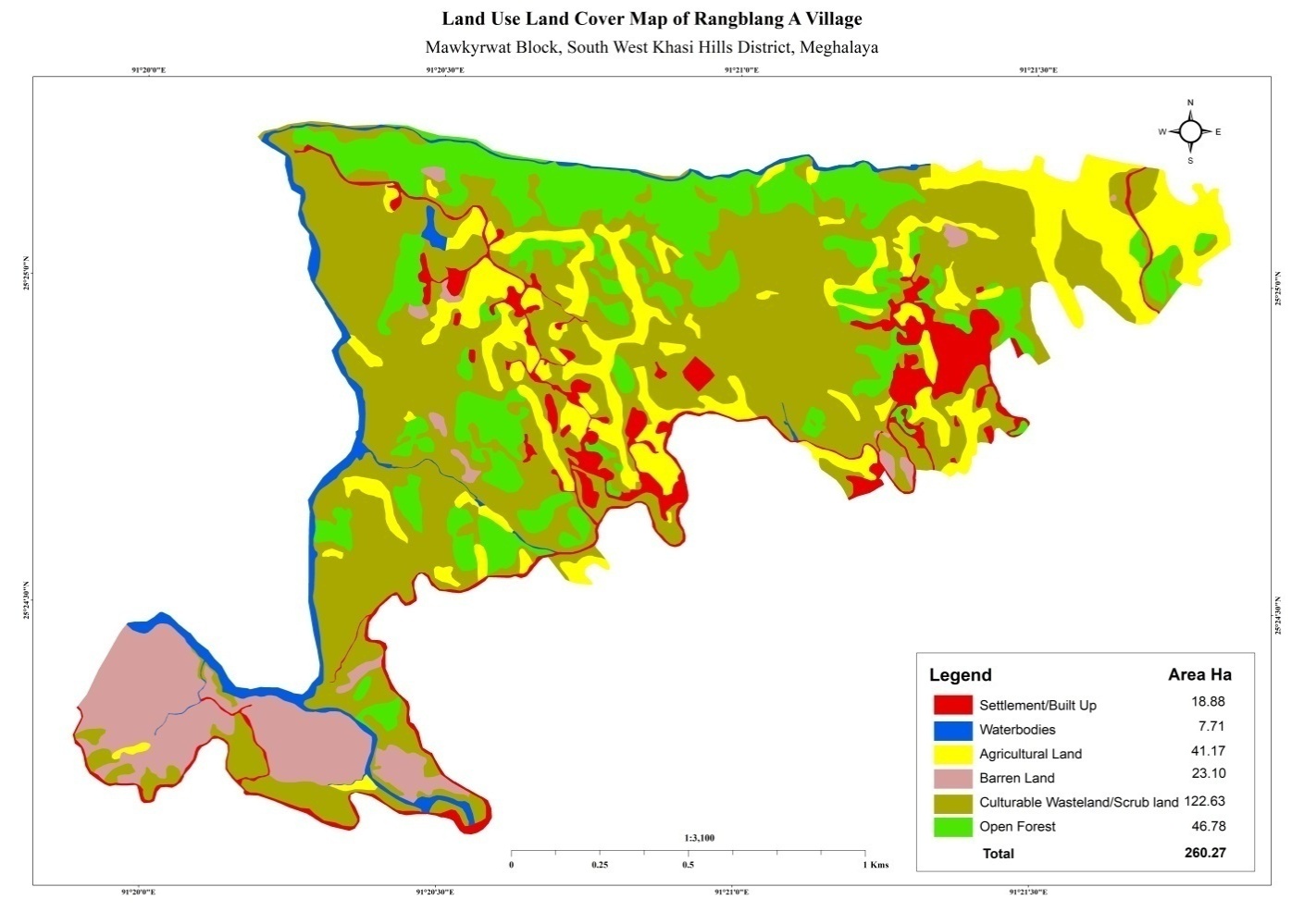 Figure: Village Land
Use Cover Map of Rangblang ‘A’ village.
Figure: Village Land
Use Cover Map of Rangblang ‘A’ village.
Figure: Slope Map of Rangblang ‘A’ village.
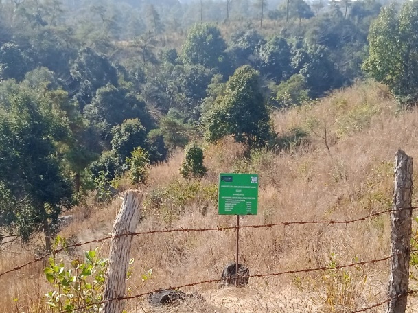
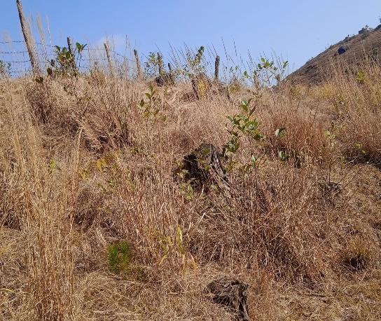
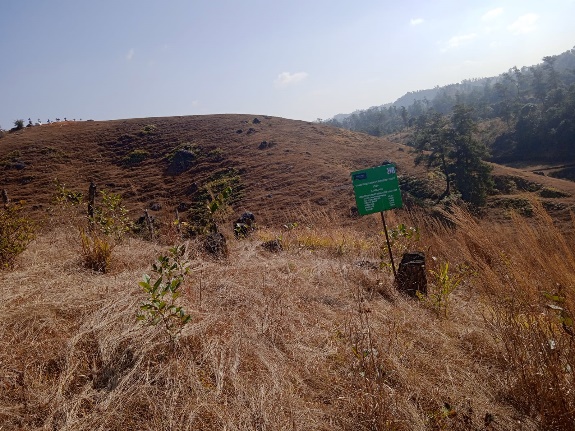
THE PROPOSED LIST OF INTERVENTIONS:
|
Name Of Proposed Interventions | Site |
|
Nos Of HH’s Expected to Benefit | Priority (High/ Medium/ Low) | ||
|---|---|---|---|---|---|---|---|
|
|
|
|||||
| 1. | Roadside Plantation | Khmahkynsep | Private |
|
|
|
High |
| 2. | Farm pond | Nongkroh Rangblang A | Private |
|
|
|
High |
| 3. | Spring Chamber & Treatment of Catchment Area | Niangsangrang |
|
|
|
|
High |
| 4. | Water Conservation Dam | Jyrhap |
|
|
|
|
High |
| 5. | Water Conservation | Mawrangblang | Private |
|
|
7 | High |
| 6. |
|
Niangsangriang |
|
|
|
|
High |
| 7. | Earthen Embankment with CC | Urkohiew |
|
|
|
|
High |
| 8. | Spring Chamber & Treatment of Catchment Area | Tiehrangblang |
|
|
|
|
High |
| 9. | Spring Chamber & Treatment of Catchment Area | Mawmit | Private |
|
|
10 | High |
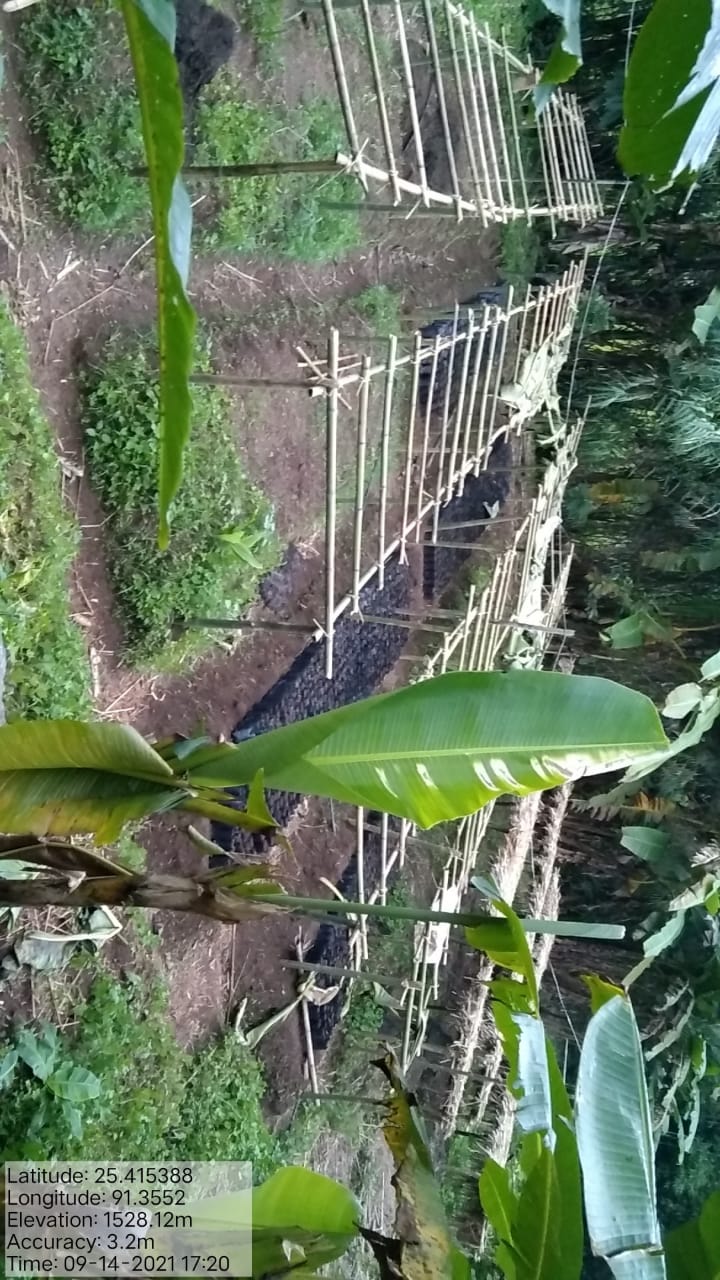
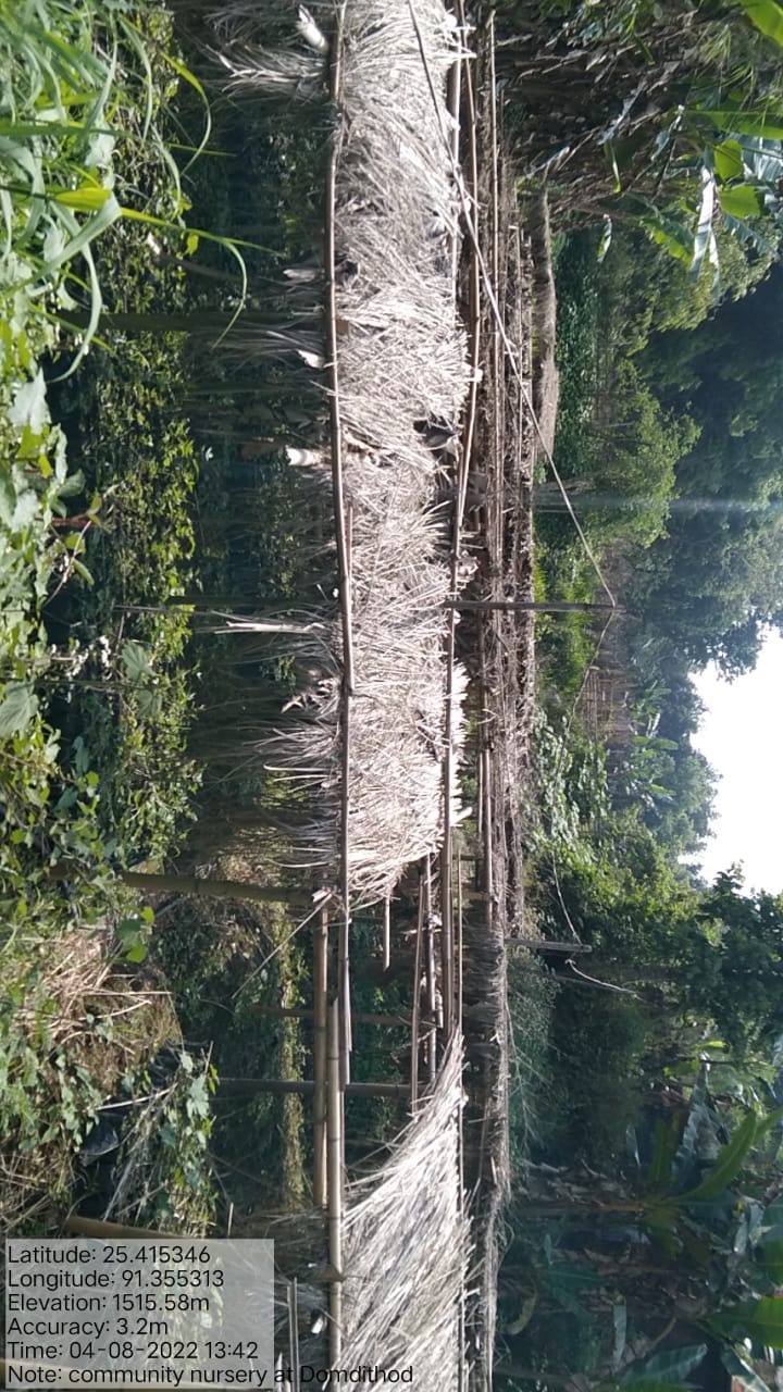
| 10. | Community Nursery | Domdithod |
|
|
|
62 | High |
| 11 | RCC Check Dam | Mawmit |
|
|
|
15 | High |
| 12 | Afforestation | Sohsat |
|
|
|
|
High |
| 13 | Afforestation | Shrahkhohwat |
|
|
|
|
High |
| 14 | Contour Trench | Rangblang |
|
|
|
10 | High |
| 15 | Roadside Plantation (Interlink Roads) | Rangblang |
|
|
|
62 | High |
PROJECT IMPLEMENTATION:
| 1. | Type Of Intervention | Site Name | GPS Co-ordinates | Amount Sanctioned | Work Status | |
|---|---|---|---|---|---|---|
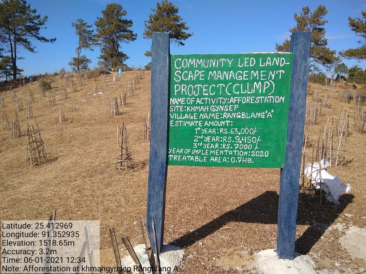
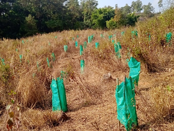
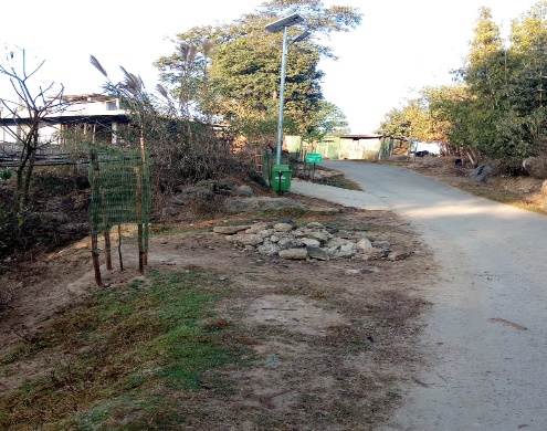
| Roadside Plantation | Khmahgynsep | 25.412969 | 91.352935 | Rs. 82,450 | Completed | |
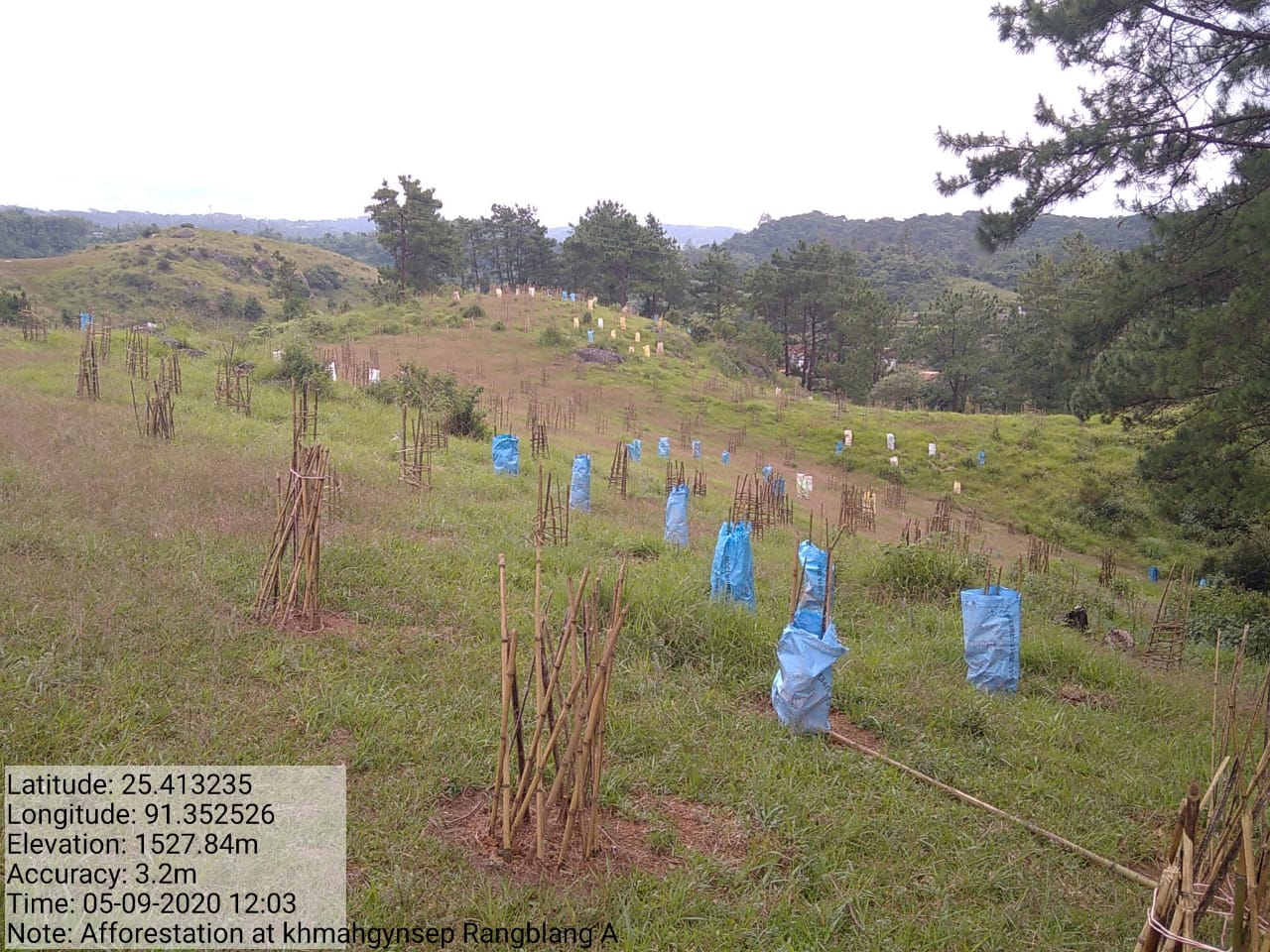
Fig: Roadside Plantation at Khmahgynsep
| 2 | Type Of Intervention | Site Name | GPS Co-ordinates | Amount Sanctioned | Work Status | |
|---|---|---|---|---|---|---|
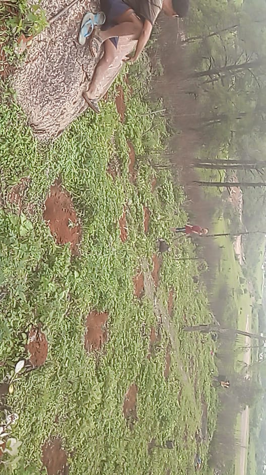
| Farm Pond | Nongkroh | 25.415327 | 91.35327 | Rs. 1,47,400 | Completed | |

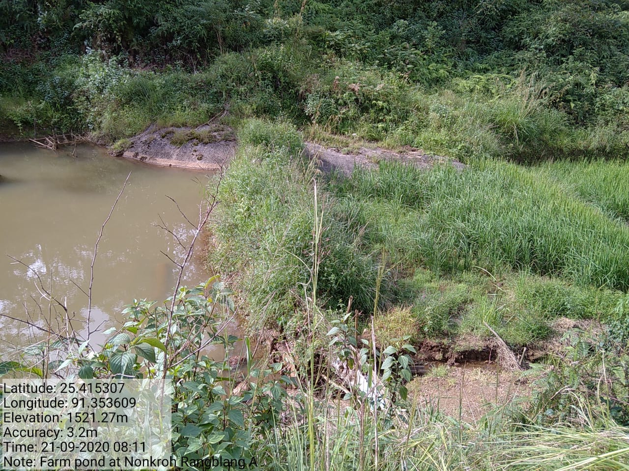
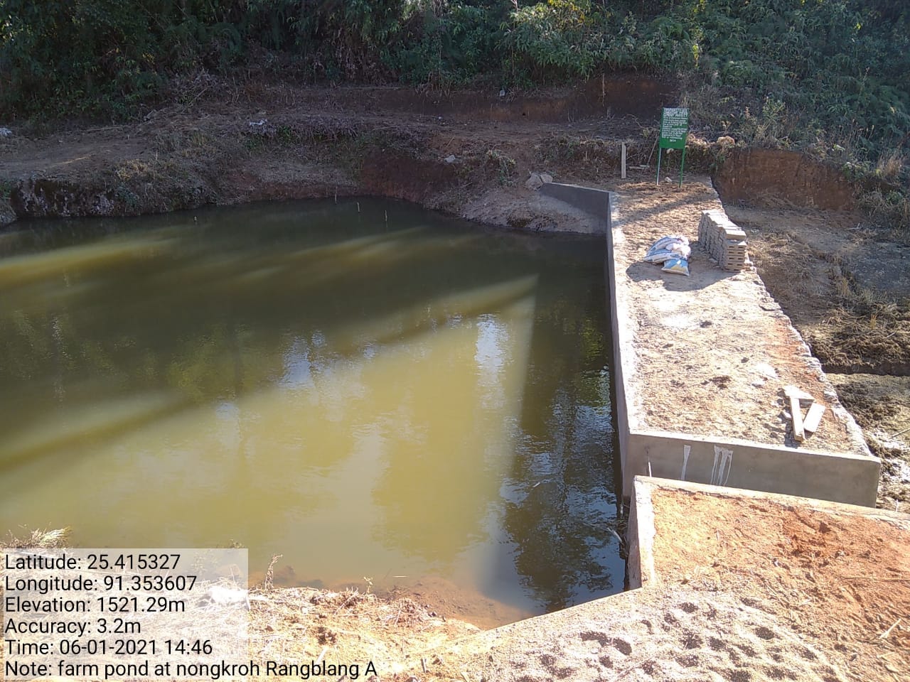
Figure: Farm Pond at Nongkroh.
| 3. | Type Of Intervention | Site Name | GPS Co-ordinates | Amount Sanctioned | Work Status | |
|---|---|---|---|---|---|---|
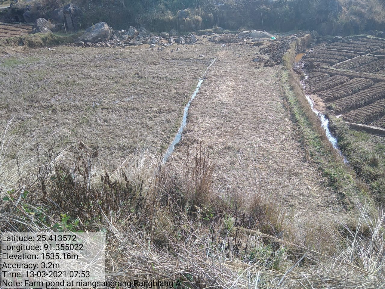
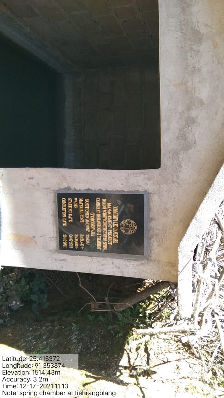
| Spring Chamber and Treatment of Catchment Area. | Niangrangsang | 25.413217 | 91.357221 | Rs. 1,04,280 | Completed | |
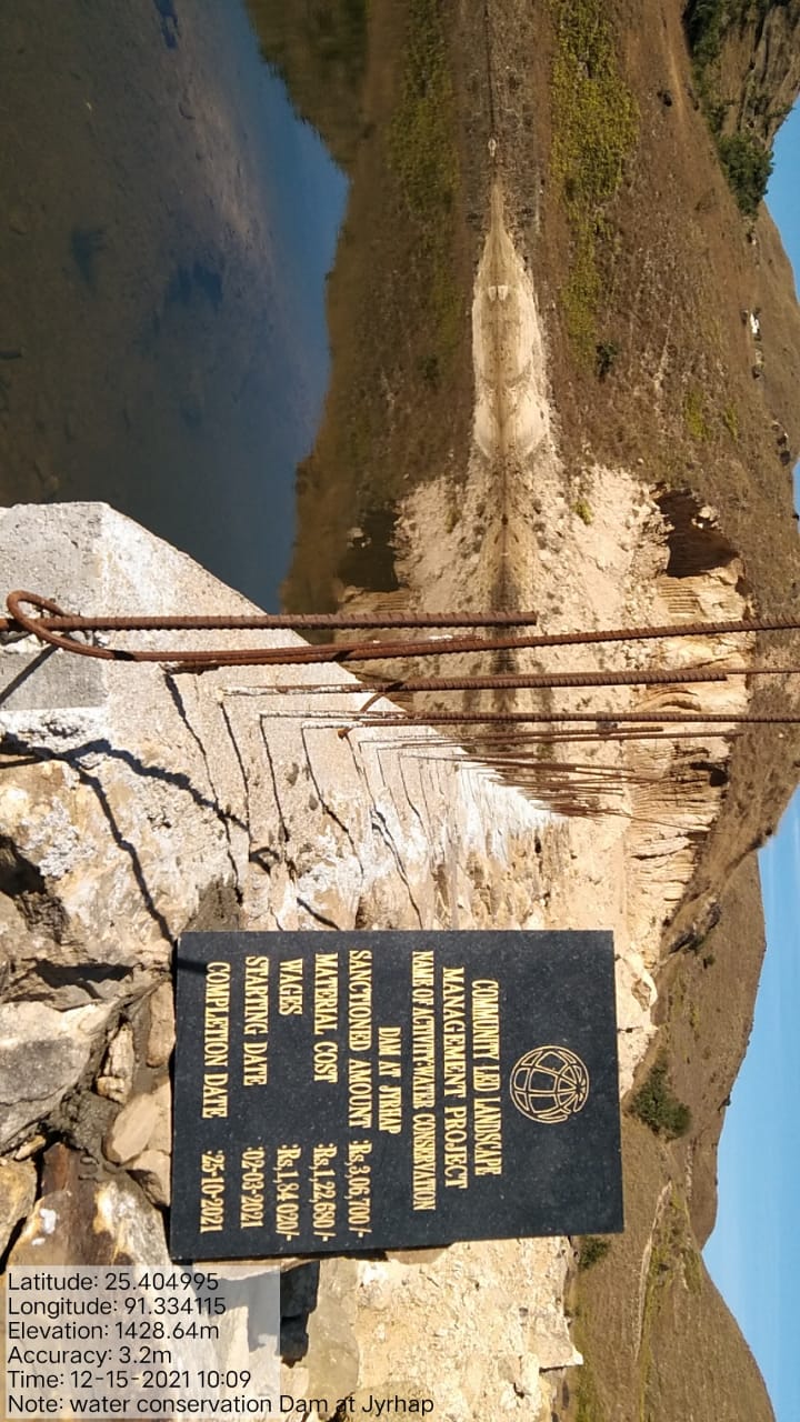 Fig:
Spring Chamber and Treatment of Catchment Area
Fig:
Spring Chamber and Treatment of Catchment Area 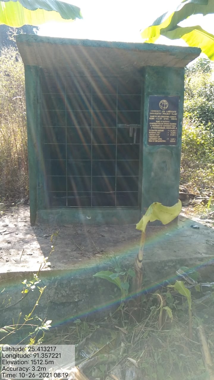
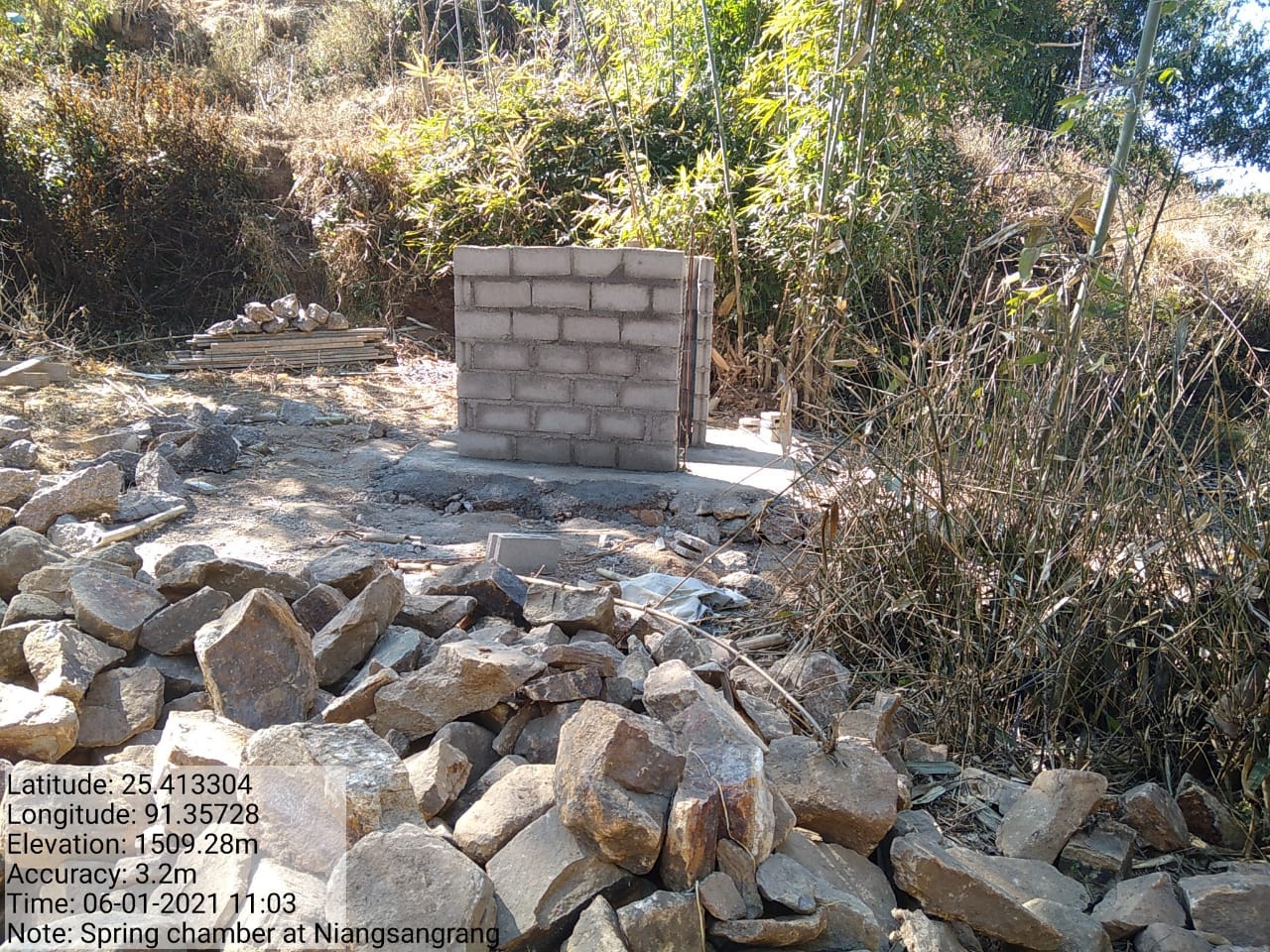 at
Niangrangsang
at
Niangrangsang
| 4. | Type Of Intervention | Site Name | GPS Co-ordinates | Amount Sanctioned | Work Status | |
|---|---|---|---|---|---|---|
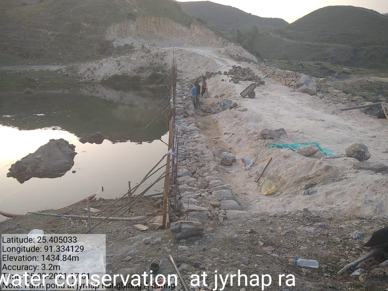
| Water Conservation Dam | Jyrhap | 25.404995 | 91.334115 | Rs. 3,06,700 | Completed | |
| 5 | Type Of Intervention | Site Name | GPS Co-ordinates | Amount Sanctioned | Work Status | |
|---|---|---|---|---|---|---|
| Water Conservation | Mawrangblang | 25.417598 | 91.355643 | Rs. 2,00,000 | Completed | |
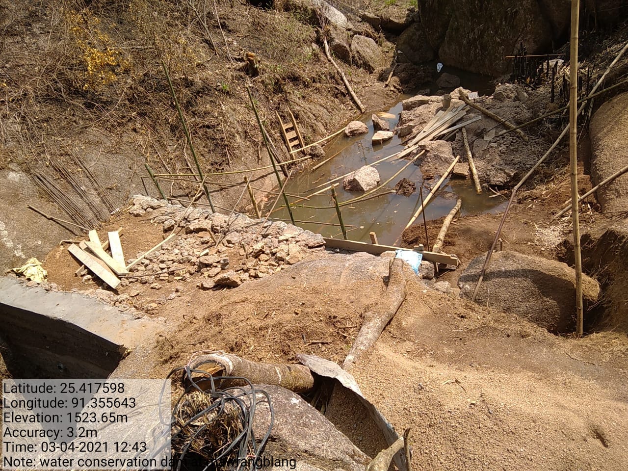
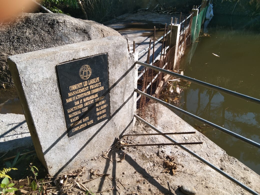
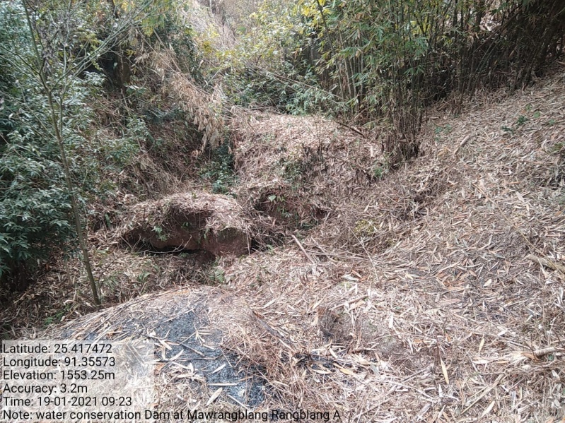
Figure: Water Conservation at Mawrangblang.
| 6. | Type Of Inte Rvention |
Site Name | GPS Co-ordinates | Amount Sanctioned | Work Status | |
|---|---|---|---|---|---|---|
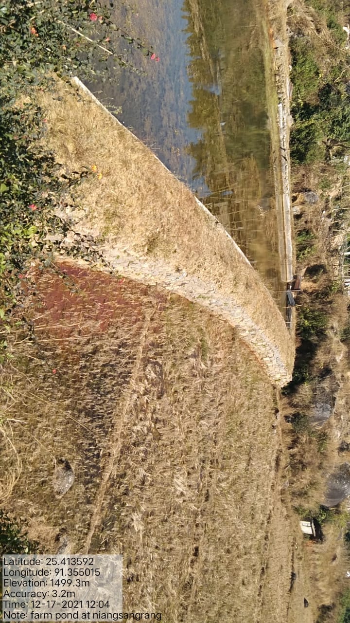
| Farm Pond | Niangrangsang | 25.413572 | 91.355022 | Rs. 3,32,000 | Completed | |
| 7. | Type Of Intervention | Site Name | GPS Co-ordinates | Amount Sanctioned | Work Status | |
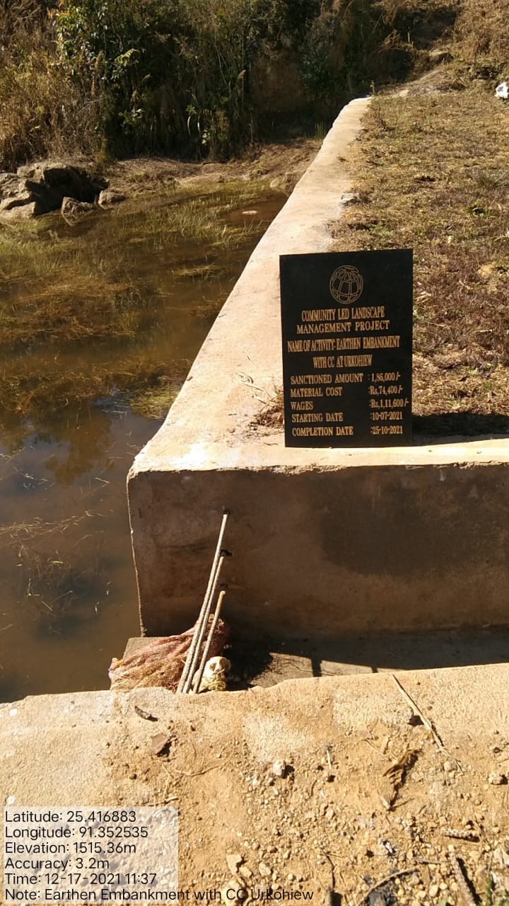
|---|---|---|---|---|---|---|
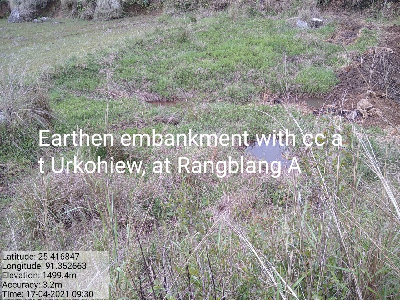
| Eastern Embarkment with CC | Urkohiew | 25.416883 | 91.352535 | Rs. 1,86,000 | Completed | |
Figure: Farm Pond at Niangrangsang.
| 8. | Type Of Intervention | Site Name | GPS Co-ordinates | Amount Sanctioned | Work Status | |
|---|---|---|---|---|---|---|
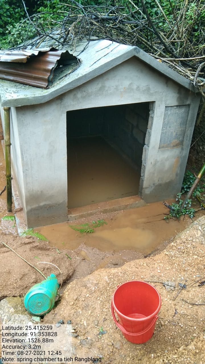
| Spring Chamber and Treatment of Catchment Area. | Tiehrangblang | 25.415372 | 91.353874 | Rs. 68,600 | Completed | |
| 9. | Type Of Intervention | Site Name | GPS Co-ordinates | Amount Sanctioned | Work Status | |
|---|---|---|---|---|---|---|
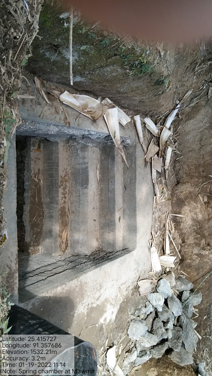
| Spring Chamber and Treatment of Catchment Area | Mawmit | 25.415727 | 91.357686 | Rs. 89,300 | Completed | |
| 10. | Type Of Intervention | Site Name | GPS Co-ordinates | Amount Sanctioned | Work Status | |
|---|---|---|---|---|---|---|
| Community Nursery | Domdithod | 25.415401 | 91.355401 | Rs. 3,21,520 | Completed | |
| 11. | Type Of Intervention | Site Name | GPS Co-ordinates | Amount Sanctioned | Work Status | |
|---|---|---|---|---|---|---|
| RCC Check Dam | Mawkohmit | 25.416847 | 91.352663 | Rs. 1,62,750 | Completed | |
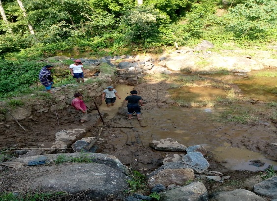
Figure: RCC Check Dam at Mawkohmit
| 12 | Type Of Intervention | Site Name | GPS Co-ordinates | Amount Sanctioned | Work Status | |
|---|---|---|---|---|---|---|
| Afforestation | Sohsat | 25.422357 | 91.349592 | Rs. 41,400 | Completed | |
| 13. | Type Of Intervention | Site Name | GPS Co-ordinates | Amount Sanctioned | Work Status | |
|---|---|---|---|---|---|---|
| Afforestation | Shrahkhohwat | 25.418046 | 91.353875 | Rs. 41,400 | Completed | |
| 14 | Type Of Intervention | Site Name | GPS Co-ordinates | Amount Sanctioned | Work Status | |
|---|---|---|---|---|---|---|
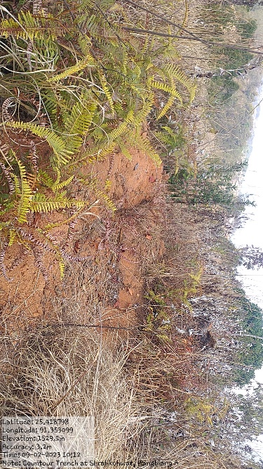
| Countour Trench | Rangblang | 25.418046 | 91.353875 | Rs. 21,600 | Completed | |
| 15 | Type Of Intervention | Site Name | GPS Co-ordinates | Amount Sanctioned | Work Status | |
|---|---|---|---|---|---|---|
| Roadside Plantation (Interlink Roads) | Ranblang A | 25.414125 | 91.355537 | Rs. 49,600 | Completed | |
FUND STATUS:
Fund Released to VNRMC (Project Implementation) |
Total No. of Work Order Issued | Total amount Issued under CLLMP (Per Activity) | Total Amount Spent | Work Order Issued Date |
Start Date | End Date |
|---|---|---|---|---|---|---|
| Rs. 21,55,000 | 15 | Roadside Plantation at Khmahkynsep = Rs. 82,450 |
Rs. 82,45 ++++++++++++++++++++++++++++++++++++++++++++++++++++++++++++++++++++++++++++++++++++++++++++++++++++++++++++++++++++++++++++++++++++++++ ++++++++++++++++++++++++++++++++++++++++++++++++++++++++++++++++++++++++++++++++++++++++++++++++++++++++++++++++++++++++++++++++++++++++++++++++++++++++++++++++++++++++++++++++++++++++++++++++++++++++++++++++++++++++++++++++++++++++++-*****************************************************************************************************************************99999999999999999999999999999999999999999999999999999***********************999999999999999999999999999999999999999999999999999999999999999999999999999999999999999999999999999999999999999999999999999999999999999999999999999999999999999999999999999999999999999999999999999999999999999999999999****************************9* ++++++++++++++++++++++++++++++++++++++++++++++++++++++++++++++++++++++++++++++++++++++++++++++++++++++++++++++++++++++++++++++++++++++++++++++++++++++++++++++++++++++++++++++++++++++++++++++++++++++++++++++++++++++++++++++++++++++++++++++++++++++++++++++++++++++++++++++++++++++++++++++++++++++++++++++++++++++++++++++++++++++++++++++++++++++++++++++++++++++++++++++++*9999999999999999999999999999999999999999999999999999999999999999999999999999999999999999999999999999999999999999999999999999999999999999999999999999999999999999999999999999999999999999999999999999999999999999999999999999999999999999999999999999999999999999999999999999999999999999999999999999999999999999999999999999999999999999999999999999999999999999999999999999999999999999999999999999999999999999999999999999999999999999999999999999999999999999999999999999999999999999999999999999999999999999999999999999999999999999999999999999999999999999999999999999999999999999999++++++++++*9999999999999999999999999999999999999999999999999999999999999999999999999---------9999999--+*999999999999999999999999999999999999999999999999999999999999999999999999999999999999999999999999999999999999999999999999999999999----------9999999----------------------99999999999999-----------99--------------------------------------------99999999999999------------------------------------------------9999999999 +++++++++++++++++++++++++++++++++++++++++++++++++++++++++++++++++++++++************9999999999999999999999999999999999999999999999999999999999999999999999999999999999999999999999999999999999999999999999999999999999999999999999999999999999999999999999999999999999999999999990 |
14th July, 2020 | 29th July, 2020 | 6th Jan 2021 |
| Farm Pond at Nongkroh = Rs. 1,47,400 | Rs. 1,47,400 | 26th August, 2020 | 21st August, 2020 | 18th Nov 2020 | ||
Spring Chamber and Treatment of Catchment Area at Niangrangsang = Rs. 1,04,280 |
Rs. 1,04,280 | 15th Sept, 2020 | 9th October, 2020 | 21st Dec, 2020 | ||
| Water Conservation Dam at Jyrhap = Rs. 3,06,700 | Rs. 3,06,700 | 11th Jan, 2021 | 2nd March, 2021 | 25th October, 2021 | ||
Water Conservation Dam at MawRangblang = Rs. 2,00,000 |
Rs. 2,00,000 | 11th Jan, 2021 | 9th March, 2021 | 25th October, 2021 | ||
Farm Pond at NIangrangsang = Rs. 3,32,00 |
Rs. 3,32,00 | 2nd March, 2021 | 31st March, 2021 | 25th October, 2021 | ||
| Eastern Eastern Embarkment with CC at Urkohiew = Rs. 1,86,000 | Rs. 1,86,000 | 2nd March, 2021 | 10th July, 2021 | 25th October, 2021 | ||
Spring Chamber and Treatment of Catchment Area at Tiehrangblang = Rs. 68,600 |
Rs. 68,600 | 2nd March, 2021 | 6th July, 2021 | 25th October, 2021 | ||
Spring Chamber and Treatment of Catchment Area at Mawmit = Rs. 89,300 |
Rs. 89,300 | 31st March, 2022 | 21st July, 2021 | 23rd February, 2022 | ||
Community Nursery at Domdithod = Rs. 3,21,520 |
Rs. 3,21,520 | 31st March, 2022 | 1st April 2022 | 30th April 2022 | ||
RCC Checkdam at Mawkohmit = Rs. 1,62,750 |
Rs. 1,62,750 | 31st March, 2022 | 6th May 2022 | 30th June 2022 | ||
Afforestation at Sohsat = Rs. 41,400 |
Rs. 41,400 | 31st March, 2022 | 18th June 2022 | 11th July 2022 | ||
Afforestation at Shrahkohwat = Rs. 41,000 |
Rs. 41,000 | 31st March, 2022 | 18th June 2022 | 11th July 2022 | ||
| Contour Trench at Rangblang = Rs. 21,600 | Rs. 21,600 | 31st March, 2022 | 18th June 2022 | 22 July 2022 | ||
| Roadside Plantation (Interlink Roads) = Rs. 49.600 | Rs. 49.600 | 31st March, 2022 | 18th June 2022 | 8th June 2022 |
GROUND TESTIMONIALS:
Miss. Carida Thyrniang
VCF M&E
The Community Led Landscape Management Project have given me an opportunity to improve and get exposure to many trainings. With the coming of CLLMP, I have gathered many information and knowledge regarding the filling of the different formats and the responsibility of maintaining the books of records which needs to be updated monthly. Recently, I have been engaged with CLLMP-MIS.
Mr. Sylvanus Thyrniang
VCF Social
With the funding from the World Bank, we have seen much changes within our villages in matters relating to the implementation of the various activities aiming at conservation of our natural resources. All activities and intervention received from the office have been benefitted by every resident of our village. Personally, I have attended many trainings conducted by the office which have been very useful to me and these have added to the knowledge of conserving our surroundings.
Jamespaul Iawphniaw
VCF Environment
From this Project I have been benefitted personally as I can test the quality of the water, pH level, water discharge, etc., with the water tracer and fill the information on the Spring Survey App which I do monthly. I also follow up quarterly on the survival rate of all plantation works and as being taught by the Staffs and External experts, I have learned the use of Note Cam App whenever I go for site visitation.
………………….****************……………………