REPORT ON
SHNGIMAWLEIN VILLAGE UNDER MAWKYRWAT C&RD BLOCK
DISTRICT: SOUTH WEST KHASI HILLS
COMMUNITY LED LANDSCAPE MANAGEMENT PROJECT


 Community Led Landscape Management Project
(CLLMP)
Community Led Landscape Management Project
(CLLMP)
The Government of Meghalaya with the financial help from the World Bank has been implementing the Meghalaya Community Led Landscape Management Project (MCLLMP). The project covers the entire state of Meghalaya and implementation of community led plans have been rolled out in phase manner throughout the state. The Meghalaya Basin Management Agency (MBMA) had facilitated the community-led planning by providing support, technical inputs and funding.
The project had strengthened community-led natural resources management in selected landscapes within the 12 districts of the state. This has been achieved through a variety of planning, capacity building, and on-the-ground interventions to promote the conservation, sustainable use of natural resources, social inclusion and community mobilisation; building traditional knowledge and learning, mapping of natural resources management; strengthening the community institutions and creating linkage with financial institutions and community organizations.
The project interventions include the preparation of community led natural resource management plans. The CLLMP has the following three components:
Strengthening Knowledge and Capacity of Communities for Natural Resources Management
Community-Led Landscape Planning and Implementation
Project Management and Governance
The project objective is “to manage and conserve the natural resources, especially forests, soil and water sources, in a manner that supports the financial and physical well-being of communities in the State”
SCOPE:
The CLLM-Programme focuses on increasing the capacities of communities and traditional institutions (TI) by adopting a landscape approach to manage their natural resources such as soil, springs and other water sources, forests and bio-diversity, etc.
The project has been planned and implemented in about 400 villages across the state.
CLLMP has a strong focus on institution-building at the village-level, by ensuring systematic capacity-building on technical and social skill-sets.
The project has also extended such trainings to communities beyond the targeted villages and support efforts made by them to access funding from various rural and natural resources initiatives and schemes.
The programme has also invested in improving the process and outcome delivery, by developing and adhering to effective systems and procedures, supported by the appropriate technology.
BENEFITS:
Benefits for community (Skills and Capacity relating to technical and managerial areas like NRM and Conflict resolution
Benefits to traditional institutions (village councils, traditional leaders, community-based organizations, SHGs etc) through Knowledge sharing, promotion of innovative approach, access to technology, technical managerial and financial support.
It has been estimated that the project has impacted around 1 lakh partners (of which 50% are women) who depend on land, forest, agro forestry.
Through the project, 55000 Ha of targeted area has been ensured with availability of water, biological resources and soil productivity, which has in turn benefitted around 400 villages and the outcomes delivery can be summarized as follows.
IMPLEMENTATION AGENCY:
The Project has been executed by the MBMA in collaboration with other partners particularly, SIRD (for training and capacity building), Department of Soil and Water Conservation, Water Resource Department, Forest Department, specifically with respect to technical inputs, safeguards management and Community NRM plan preparation.
PROJECT PERIOD:
2018-2023 (5 years)
Table of contents:
Introduction and History………………………………………………4-5
Social Profile …………………………………………………………..5
Village accessibility……………………………………….5
Literacy rate……………………………………………. 5
Population……………………………………………... 6
Occupation…………………………………………….. 7
Village organisation……………………………………. 7
Fuel Type………………………………………………7
Drinking Water………………………………………...8
Cultivatable Land………………………………………8
Forest Cover…………………………………………….8
Forest Species……………………………………………8
Water Bodies…………………………………………….9
Areas affected…………………………………………..9
III. CLLMP Activities
Ground-Truthing…………………………………………………………9
Sensitization on CLLMP………………………………………………10
Signing of EOI, VGA and Green Charter……………………………..11
Formation of VNRMC…………………………………………......11-12
Village Community Facilitators………………………………………..13
Purchase Committee …………………………………………… ……..14
IV. Opening of Bank Account …………………………….……………………..14
V. PRA Exercise………………………………………………………………….14
Basic Survey for CNRMP template…………………………………….15
Focussed Group Discussions………………………………………15-16
Village Boundary Mapping and Resource Mapping……………….…17
VI. GIS Activities……………………………………………………………..18-19
VII. The Proposal list of intervention…………………………………………….20
VIII. Project Implementation ………………………………………… ……..21-40
IX. Fund Status ………………………………………………………………41-43
X. Ground Testimonials ………………………………………………………44-47
INTRODUCTION:
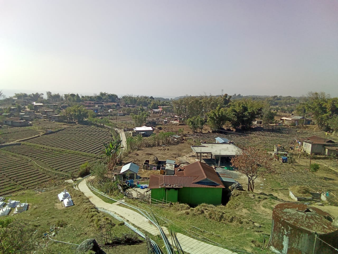
Shngimawlein village is situated in South West Khasi Hills District under the Mawkyrwat C&RD Block. The village is about 18 Km away from the District Headquarters i.e., Mawkyrwat and about 20Km away from the Block Headquarters. It has a total geographical area of 239.70ha and falls under the Hima Maharam Syiemship. Shngimawlein village has a total population of 1550 comprising of 738 males and 812 females. All the residents of Shngimawlein village belonged to the Khasi Scheduled Tribe. The average rainfall of this village is 1200mm and the type of soil is mainly loamy soil.
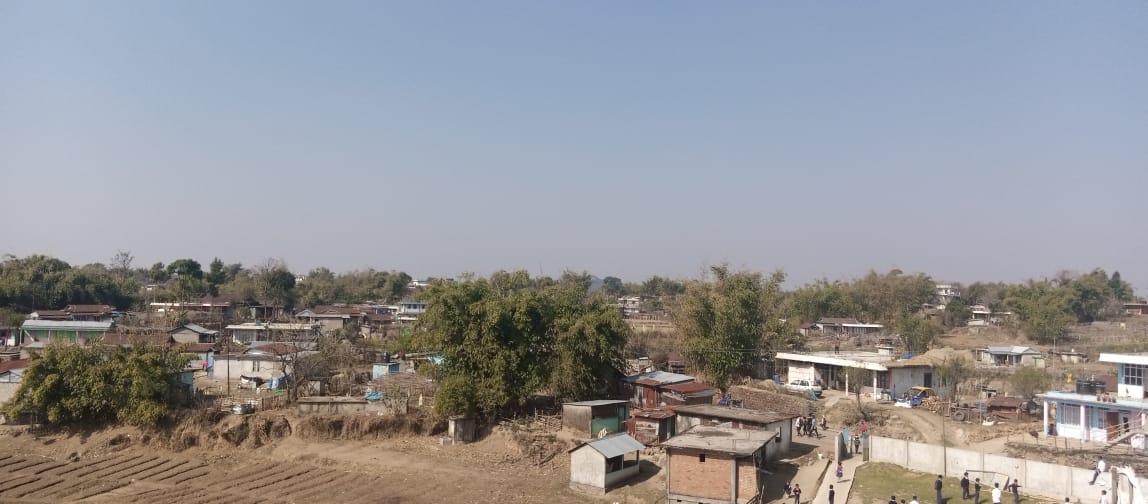
Fig: Shngimawlein village
BRIEF HISTORY ABOUT THE VILLAGE:
The name “Shngimawlein” comes from two words “Sngi” meaning “Sun” and “Mawlein” which means “Flintstones”. It was named so by the elders because of the presence of many Flintstones in the village. The first myntri as recalled by the elders was Shri. Noren Wanniang and this headman was also in charge of the adjacent areas which includes Sohma, Nongbrei-Nongdom, Shngimawlein, Pyndenumsaw, Laitnong, and Pyndenmawthawiang. After the passing of Shri. Noren Wanniang, the areas under his headmanship were divided into their own villages and the Shngimawlein village elected their own Myntri Shri.Shaiddro Wanniang and Secretary as R.Thongni and the Mr. Stailand Nongrum is the current Myntri while Shri.Spanding Lyngdoh as the secretary.
VILLAGE SOCIAL PROFILE:
Shngimawlein village has a total number of 220 households, having a total population of 1550 villagers. People in this village mainly depend on agriculture and its allied activities for their livelihood. There are teachers, businessmen and some others are engaged with government services.
Village Acessibility:
In order to reach Shngimawlein village one must travel by road with local taxis via Mawkyrwat -Nongstoin Road. The following are the villages en route: Jakrem – Sakwang – Nongbah – Jashiar – Mawthawiang – Pyndenmawthawiang, Laitnong – Shngimawlein.
Literacy Rate:
As per 2011 Census, Shngimawlein has a higher literacy rate compared to the State’s average. The village literacy rate was 76.13% while the State average stands at 74.43%. The male literacy rate was higher at 81.40% than that of the female literacy rate which stands at 70.50. There are 12 schools in this village, where 9 are Primary Schools and 3 are Secondary Schools.
Population:
As per 2011 Census, the total population of Shngimawlein village is 888 people and this has seen an increased over the years and now stands at 1550 as of the recent survey. Out of this, 738 are male and the female count is 812. About 395 total number of people belonged to the age group of 15-30 years, thus this indicates that the majority of the population of this village comprise of the young and healthy people.
| Age Group | Male | Female | Total |
|---|---|---|---|
| 0-4years | 135 | 189 | 324 |
| 5-14years | 165 | 175 | 340 |
| 15-30years | 205 | 190 | 395 |
| 30-60years | 130 | 159 | 289 |
| Above 60years | 103 | 99 | 202 |
| Total | 738 | 812 | 1550 |
Occupations:
The people of Shngimawlein village rely mainly on agriculture and forest produce for their livelihood. Out of 220 households within the village, 70 households are farmers, 100 households are labourers, while 20 household are businessman and 30 households are engaged in government services.
Organisation within the Village:
There are 12 Self Help Groups (SHGs) under NRLM within the village under one Village Organisation. Presence of a committee relating to Water and Sanitation within the village. There are also 10 VEC & traditional institutions within Shngimawlein village.
Fuel Type:
The people of this village mainly use wood as a fuel. About 150 households depend on wood gathered from the forest for their daily requirement.
| Type of Fuel | Total No of HH | Qty (Kgs/HH) | Total |
|---|---|---|---|
| Wood | 180HH | 9000kg | 1620000 kg |
| LPG | 20HH | 105kg | 2100kg |
| Charcoal | 20HH | 420kg 1 Year | 8400kg |
Drinking Water:
The people of Shngimawlein have access to drinking water mainly from the springs within the village. Government water supply lines are also available in this village. But over the years there has been a scarcity of water supply in this village due to less water discharge from the springs source and due to the increase in human population and their daily requirements. There are 5 springs within the village which are perennial that people use for drinking viz. Domkhlaw, Phot Lyngdoh, Phot Kyrtep, Mawjunai, Blein Blein.
Cultivable Land Cover:
The total agricultural area of this village is 80.24ha and the type of soil is Loamy soil. People practise bun cultivation and shifting cultivation in their own private lands. The main crops of Shngimawlein village are Paddy, Maize, Potato, Yam, Sweet Potato, Mustard, Beans, Pumkin & Chayote. They also plant Bayberry, Crab apple, Mulberry, Passion Fruit, Black berry and Peach in their own garden.
Forest Cover:
The total forest cover under this village is 65.1ha. Most of the forest cover are on private land and the quality of the forest varies from dense to moderate. People uses the forest products mainly for fuelwood, timber, as medicines, aromatic plants and for other purposes. The Clan Forest belongs to the Nongsiej, Lyngdoh, Kharwar and Jyrwa while most of the forest cover falls on the private land and they are at Mawjatsya, Swetlar, Domphyllong, Ramjynkhit, Shnongtikut, Maramdah, Mawwan, Badenshrah, Sohlang, Laitkynja, Rangeisohpian forest.
Forest Species:
Some of the indigenous tree species found in this village are Dieng Kseh, Dieng Alda, Dieng Ngan, Dieng Ksehbilat, Dieng sning, Dieng Sai, Dieng Loin, Dieng Lyngba, Dieng Rai, Dieng Sohpian, Dieng doh, Diengshit, Dieng Sohphie, Dieng Lapiar, and Diengtanglung. There are some plant species used by the people of the community for medicinal purposes and some valuable grasses like Jajiaw, jarain, jale, merihai jamyrdoh, jatira, slatyrkhang. The forest is home to many vulnerable fauna-like wild birds and rabbits.
Water Bodies:
Total area of water bodies in Shngimawlein is 7.50ha. There are about 5 springs within the village which people use mainly for drinking purpose. They have many streams within the village which are all perennial and are mainly use for washing, irrigation and fisheries. Some of the main streams are Umjin, Nongbah, Kroh Tyriun, Phod Buiaid, Rngi malah and the rivers within the village geographical area are Wah Rilang and Mawliwai.
Areas Affected:
The total degraded land within Shngimawlein village is estimated to be around about 40.5ha. 26.72ha of forest land have been degraded over the years due to soil erosion, forest fires, excessive felling of trees which have led to the loss of productivity of the land and the loss of the saplings and other natural resources. About 8.62ha of cultivable land have been affected by the excessive use of fertilizers and 5.16ha of land have been degraded over the years owing to human settlement, culturable wastelands and grassland.
CLLMP ACTIVITIES:
Ground Truthing: On 15th November, 2018, the District Project Management Unit (DPMU) visited Shngimawlein village for Ground Truthing and the Headman of the village provided the CLLMP Team with important information regarding the current scenario of the landscape and the natural resource management under his headmanship.
Case Findings:
The village has more than 200 HH. Out of the 200 HH, 27% falls under BPL, 47% with ration cards and 26% with health cards.
It has an actively performing VEC.
Availability of two clan forests
The village mostly faces water scarcity as the water source is located downhill whereas the residential area is located uphill Water management is also a huge issue in the village and with no proper access to drinking water and a lack of catchment areas, there has been a rise in community problems.
Sensitization Programme:
The sensitization programme of Shngimawlein village was conducted on the 12th December, 2019. The programme was attended by 200 people and a detailed presentation was given by the DPMU-CLLMP team. The VNRMC of Shngimawlein was also formed on the same day, the VNRMC also selected the members to the EC as well as six youths as VCF (three main VCFs and three stand by).
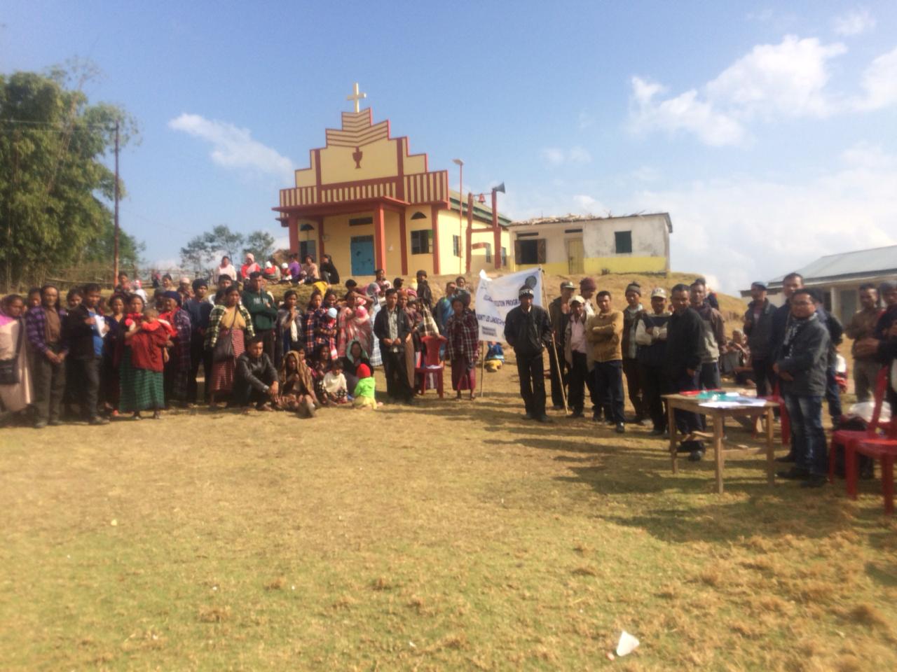
Fig: Villagers attending the Programme.
Highlights of the meeting:
1. Awareness about the Community Led Landscape Management Project (CLLMP).
2. Laying the importance on the involvement of the community in making the CNRM plan and its success.
3. A brief awareness on cleanliness was conducted based on our finding during the ground truthing phase.
4. An interactive session was held to answer doubts of the villagers regarding the project.
Signing of EOI, VGA and Green Charter:
After the interactive session, the village signed the EOI, VGA and Green charter followed by the selection of candidates for the Village Natural Resource Management Committee. The Village Executive Committee (VEC) and the entire community carried out the procedure and elected the members of the VNRMC on the same day.
Formation of the VNRMC:
The Formation of the Shngimawlein Village Natural Resource Management Committee was done in a public meeting on the 12th December 2021 in the presence of the entire village and the CLLMP staffs. The community itself chose the President, the Secretary and the other executive members of the Committee.
List below are the members of the VNRMC:
| Village Natural Resource Management Committee (9members committee constituted from Village Council, SHG group, Women’s group, youth, VEC) | ||||||||
|---|---|---|---|---|---|---|---|---|
| Sl No. | Name | Designation | Gender (M/F) |
Age (in yrs) | Qualification | Occupation | Community | Phone No. |
| 1. | Khlingdar Wahlang | President | M | 41 | MA | Teacher | Khasi | 9402544855 |
| 2. | Balari Lyngkhoi | Secretary | F | 28 | XII | farmer | Khasi | 9436139027 |
| 3. | Elishnga Lyngkhoi | F. Secretary | M | 30 | XII | MECL | Khasi | 8787666845 |
| 4. | Dricsparland wahlang | Member | M | 40 | XII | Teacher | Khasi | 9612365452 |
| 5. | Banjop Rangksai | Member | M | 45 | BA | Teacher | Khasi | 8787748905 |
| 6. | Romiland Nongrum | Member | M | 35 | BA | Teacher | Khasi | 6909132736 |
| 7. | Bijoylin marwein | Member | F | 25 | BA | Teacher | Khasi | 7005662162 |
| 8. | Jitamerry Wahlang | Member | F | 28 | BA | Teacher | Khasi | 9366234709 |
| 9. | Jili Lyngkhoi | Member | M | 30 | BA | Teacher | Khasi | 9366039657 |
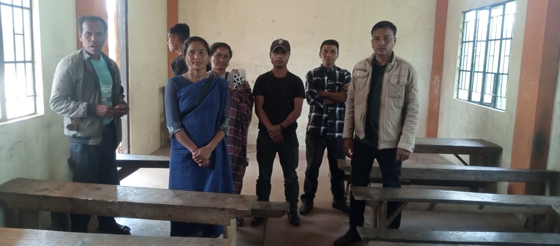
Fig: Executive Members of Shngimawlein VNRMC.
| Traditional village institutional Functionaries (Village Dorbar Council) | ||||||||
|---|---|---|---|---|---|---|---|---|
| Sl No | Name | Gender | Age | Education | Designation | Occupation | Community | Contact No. |
| 1 | Stailand Nongrum | Male | 48 | BA | Myntri | Teacher | Khasi | 9402544855 |
| 2 | Spanding Lyngkhoi | Male | 40 | BA | Secretary | Teacher | Khasi | 9436139027 |
| 3 | Banjop Rangksai | Male | 42 | XII | Member | Teacher | Khasi | 8787748905 |
| 4 | Pliston Wannniang | Male | 52 | III | Member | farmer | Khasi | 9366341422 |
| 5 | Khlingdar wahlang | Male | 43 | BA | Member | Teacher | Khasi | 8787666845 |
| 6 | Dricsparland wahlang | Male | 44 | BA | Member | Teacher | Khasi | 9612365452 |
| Village Community Facilitators (VCF) | ||||||
|---|---|---|---|---|---|---|
| Sl no. | Name | Gender | Age | Qualification | Contact Number | Role |
| 1. | Lokistar Mawlong | M | 20 | XII | 6009527390 | SM & KM |
| 2. | Amstraitlan Syiemlieh | M | 18 | XII | 6009342234 | Envt & GIS |
| 3. | Pensing Wahlang | F | 22 | BSc | 9366040036 | M&E |
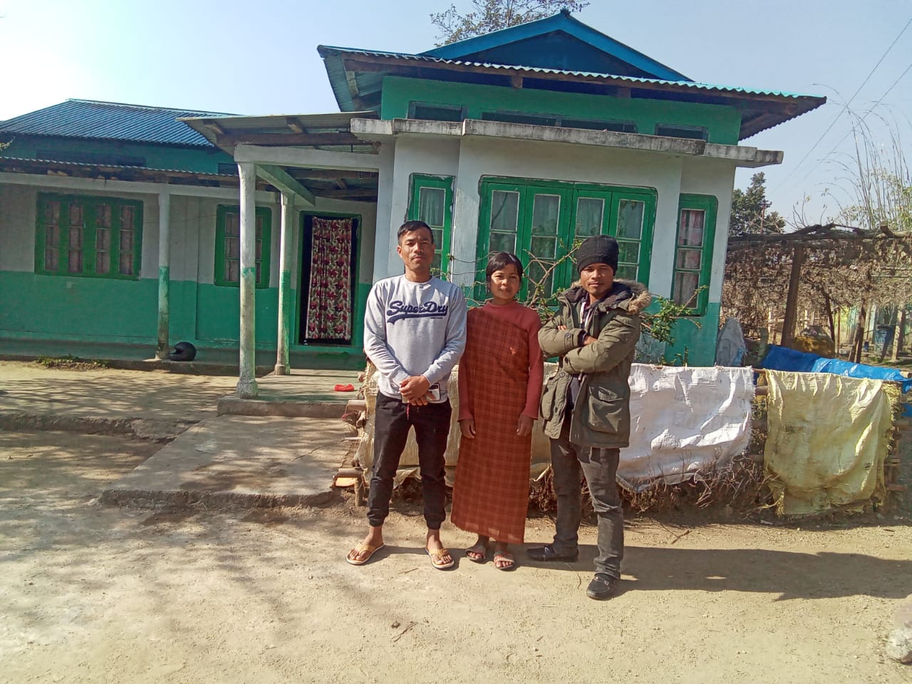
Fig: VCF of Shngimawlein VNRMC.
| Procurement Members | |||||
|---|---|---|---|---|---|
| Sl no. | Name | Age | Gender | Qualification | Contact Number |
| 1. | Tlanding Wahlang | 43 | M | V | 936602179 |
| 2. | Yiarlin Lyngkhoi | 38 | F | VII | NA |
| 3. | Nasia Wahlang | 35 | F | IX | NA |
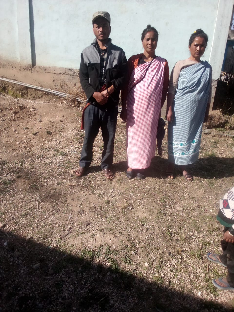
Fig: Purchase Committee members.
Opening of Bank Account:
The opening of the bank account was done after the signing of the EOI (Expression of Interest), the VGA (Village Grant Agreement) and the signing of the Green Charter. The Accountant of CLLMP South West Khasi Hills trained the Purchasing and Procurement Committee of Shngimawlein village on matters relating to Accounts and Book Keeping and on the:
Principles of Community Procurement
Benefits of Community Procurement
Important aspects undertaken by Community Procurement.
Procurement Process/Steps
Function of Purchase Committee
Important Procurement records to be maintained
Financial limits and methods
Maintaining of Books of Accounts to the Book Keeper.
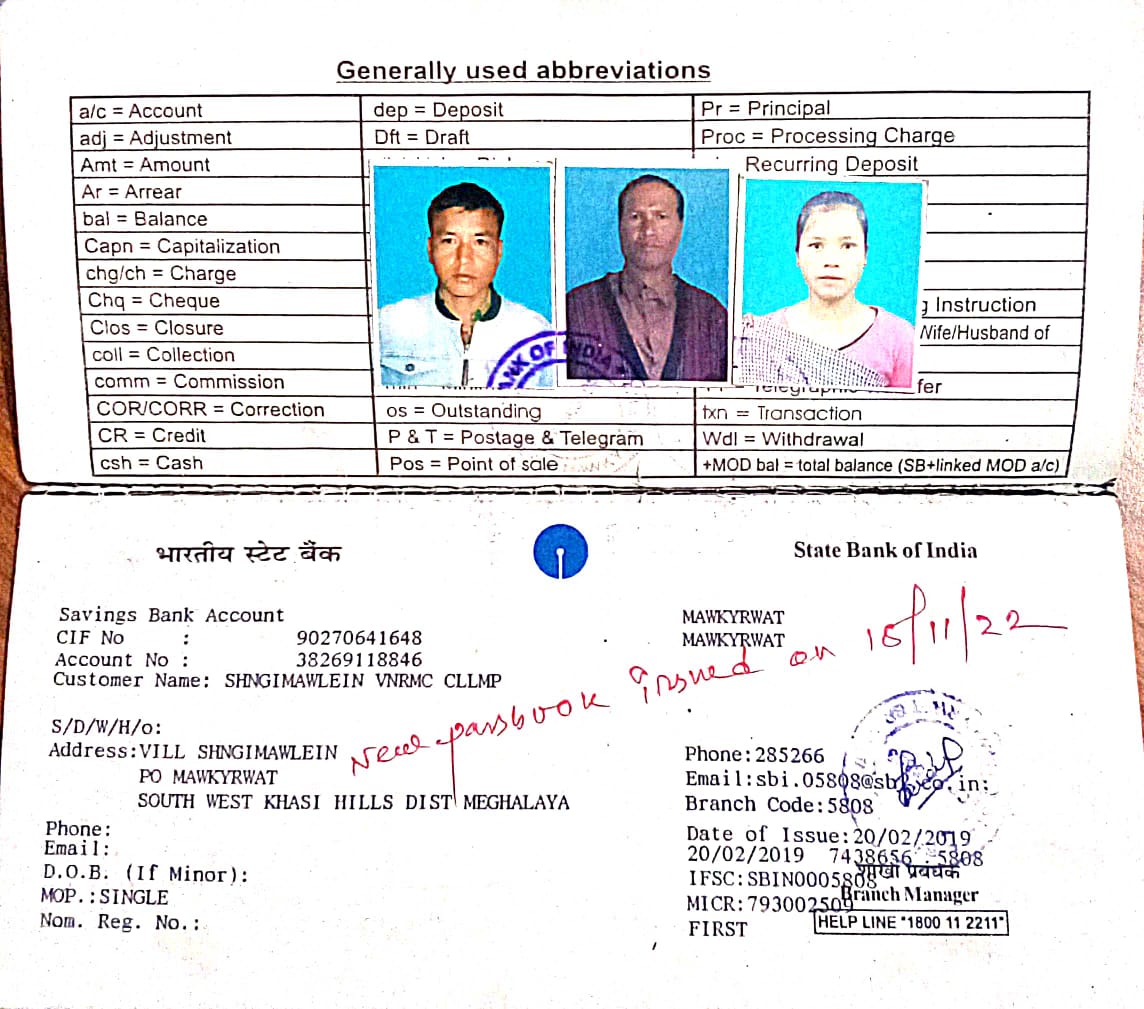
Fig: Bank details of Shngimawlein.
Participatory Rural Appraisal Exercise:
The PRA exercise aims to incorporate the knowledge and opinions of the community in the planning and management of development projects and programmes. PRA exercise at Shngimawlein village took place on the 13th December, 2020. There was a total of 220 villagers taking part in this exercise who contributed their time and knowledge to this project.
Findings based on the information gathered from the participants during the PRA/CNRMP exercise:
1. The main agricultural produce is Paddy, Maize and Potato.
2. Most of the household depend on firewood as a source of fuel.
3. Drinking water is limited over a period of 2-3 months during the winter season.
4. There are two types of forest ownership: Clan and Private.
5. There are few Clans Forest.
6. The springs which are present in the village needs rejuvenation.
7. Training on Land productivity, Spring shed management and Community nursery is necessary for the village community.
Baseline Data Survey to fill the Environment and Social Template:
During the PRA Exercise a group discussion with the different groups to gather basic village information regarding number of households, demographic information, major crops and enterprises taken in the village, trends of production and productivity of major crops in the village and demographic distribution of village population.
Information related to land use category such as forest, cultivable land, water bodies, etc and the problems and challenges related to NRM were discussed.
Focussed Group Discussion on Problem Analysis:
Do people have sufficient access to supply of fodder, fuel wood, leaf litter?
Yes, people in the village have sufficient access to supply of fodder, fuel wood, leaf litter. They get it from the community forest and from their own private lands/forest.
Has access to timber improved or reduced over the years? How is access for household use and commercial use managed?
Yes, access to timber has reduced over the years. People have to purchase it from neighbouring village when needed.
Are the water bodies facing any threats?
So far, the water bodies within the village are faced with some minor threats.
Do all people in the village have access to drinking water? What are the challenges?
Yes, there is sufficient drinking water in the village, except during the winter season (February to March) due to less discharge of water from the spring source.
Are there degraded areas in the village (open/ degraded forests, mining affected, high soil erosion etc.)?
There are some minor degradations in cultivated land.
What has caused this degradation? Are there practices causing threats to availability and access to natural resources?
Fertility of the soil has decline over the year.
The practices that cause threat to the availability of these resources are:
Forest fires that take place occasionally.
What have been the changes in agricultural practices?
Over the years with much awareness people have practiced crop rotation.
Are there any challenges in farming?
The main challenges faced by the people of Shngimawlein village is that over the years they have seen a decline in the soil productivity due to soil erosion.
How would you consider the health situation in your village?
The people of Shngimawlein have a Primary Health Centre within their own village which also cater to the people of the adjacent villages.
is the situation of cleanliness, sanitation, access to toilets and waste management?
The SHG members is responsible for organizing the cleaning drive once a week.
Sufficient toilets are available in every household but most of the constructions are poor. Some households have access to toilets from SBM (Swash Bharat Mission) scheme. The presence of VWSC in the village has also improve sanitation and cleanliness. But Waste Management is poor because people are not really aware of how to properly disposed off waste.
Who are the most vulnerable in the village? What can be done to improve their lives?
BPL Families. Inclusion of BPL family members during project implementation.
What are the livelihood aspirations of the youth? Are there any avenues available?
None, except daily wages labourers.
Do any committees/ institutions/ rules exist to manage and monitor natural resources in the village?
The VNRMC under the CLLMP is the main committee that is now in place to manage the natural resources in the village.
What are some of the major issues of conflict in the village?
Nothing related to NRM.
Have any of the above issues been discussed in village meetings?
NA
How do people resolve disagreements and conflicts?
All disagreements and conflicts are addressed by the traditional institution of village called the Village Dorbar.
Village Boundary Mapping and Recourse Mapping:
The GIS personnel along with the Village Community Facilitators mapped the village boundary of Shngimawlein Village.
The village resource map is prepared by the people of the community. In this resource map, the local people prepare it by drawing it on chart paper. Recourses such as agricultural lands, wells, wastelands, cattle population, playgrounds, ICDS, churches, community halls, etc were mapped.
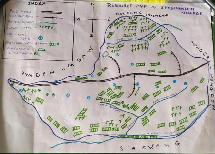
Fig:Resource map of Shngimawlein village.
GIS Activities:
| Sl. No. | Parameters | Village Information |
|---|---|---|
| 1 | GPS Coordinates: | |
| i | Latitude | 25.420374 |
| ii | Longitude | 91.485012 |
| iii | Elevation Reading (MSL) | 1651 |
| 2 | Village Geographical Area (Ha) | 239.70Ha |
| i | Total Forest Area (including community, Clan, Pvt Forest) | 65.1Ha |
| ii | Total Area of Water Bodies | 7.50Ha |
| iii | Total Area under Agri-Horticulture | 80.24Ha |
| iv | Total Degraded land area (Ha) | 40.5Ha |
| 3 | Average Annual Rainfall | 12000mm |
| 4 | Soil Type | Loamy soil |
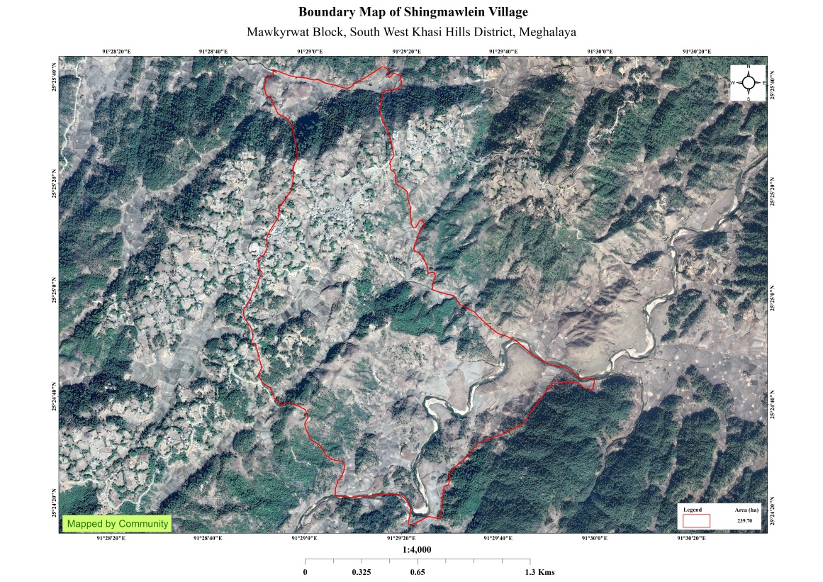
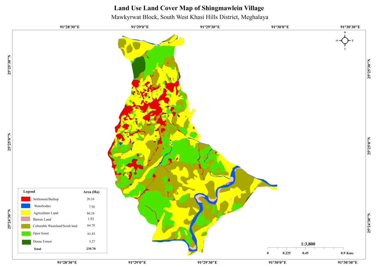
Fig: Boundary Map and LULC Map.
The Proposed list of Interventions:
|
Name of Proposed Interventions | Site |
|
Nos of HHs expected to Benefit | Priority (High/ Medium/ Low) |
|---|---|---|---|---|---|
| 1. | Spring Chamber &Treatment | Domkhlaw |
|
15 |
|
| 2. | Spring Chamber &Treatment | Photlyngdoh |
|
|
High |
| 3. | Spring Chamber &Treatment | Phorkyrtep |
|
|
High |
| 4. | Spring Chamber &Treatment | Mawjunai |
|
|
High |
| 5. |
|
Blein Blein |
|
|
High |
| 6. |
|
Nongbah/Liewlong |
|
|
High |
| 7 | Community Nursery | Lyngdoh |
|
|
High |
| 8 | Afforestation | Mawbah-Mawkawan |
|
|
High |
| 9 | Boulder Bund | Mawbah |
|
|
|
| 10 | Boulder Bund | Mawlwai |
|
|
|
| 11 | Boulder Bund | Phorbuaid 1 |
|
|
|
| 12 | Boulder Bund | Mawkyllein 1 |
|
|
|
| 13 | Boulder Bund | Mawkyllein 2 |
|
|
|
| 14 | Boulder Bund | Phorbuaid 2 |
|
|
|
| 15 | Piping Irrigation Cum Water Reservoir Tank | Mawbah |
|
|
|
| 16 | Improvement of Existing Degraded Forest | Lawlyngdoh |
|
|
|
| 17 | Afforestation | Nongbah |
|
|
|
| 18 | Afforestation | Rngi Lyngdoh |
|
|
|
| 19 | Afforestation | Rngibaniang |
|
|
|
| 20 | Afforestation | Tyngkur |
|
|
|
| 21 | Boulder Bund | Thangpari |
|
|
Project Implementation:
| 1. | Type Of Intervention | Site Name | GPS Co-ordinates | Amount Sanctioned | Work Status | |
|---|---|---|---|---|---|---|
| Spring Chamber and treatment of Catchment Area at Phorkyntep | Phorkyntep | 25.423064 | 91.488407 | Rs.42,450 | Completed | |
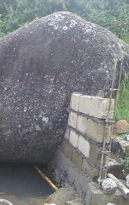

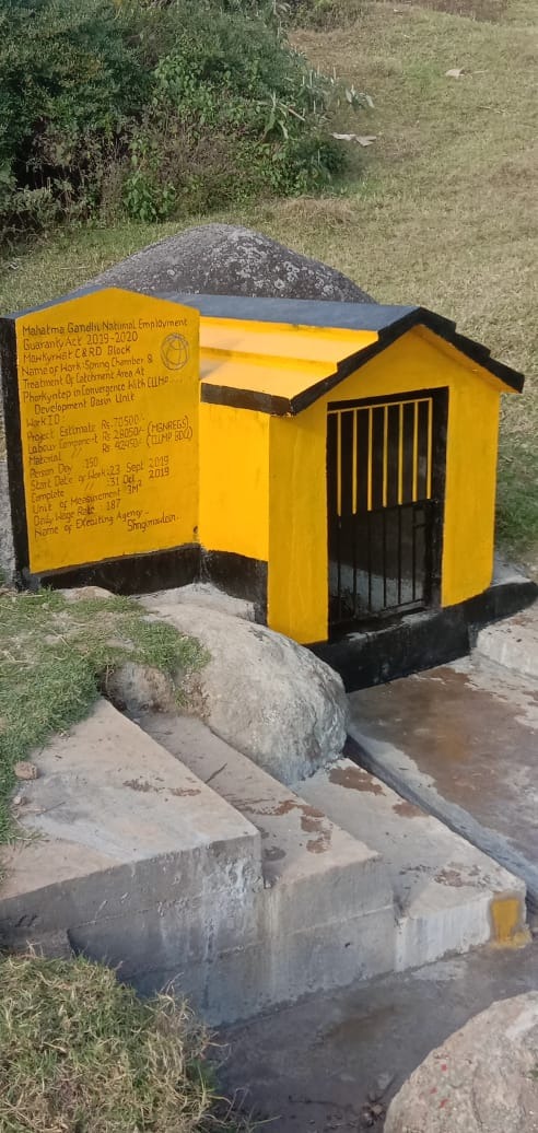
Fig: Spring Chamber and treatment of Catchment Area at Phorkyntep
2. |
Type Of Intervention | Site Name | GPS Co-ordinates | Amount Sanctioned | Work Status | |
|---|---|---|---|---|---|---|
| Spring Chamber and treatment of Catchment Area at Phodlyngdoh | Phodlyngdoh | 25.423012 | 91.483532 | Rs.44,450 | Completed | |
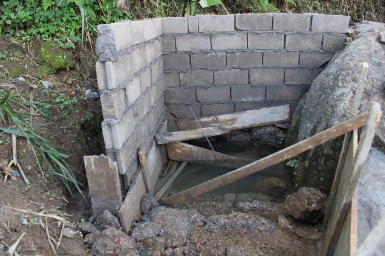
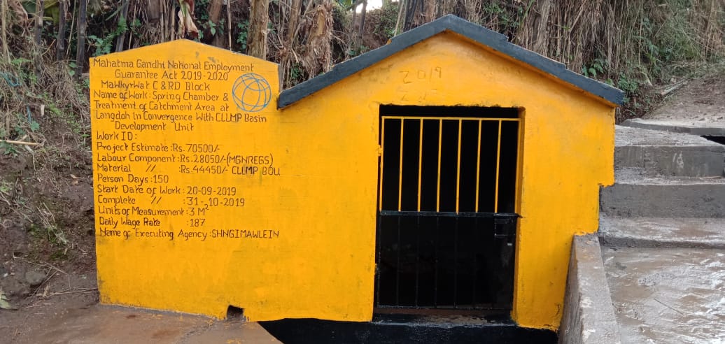
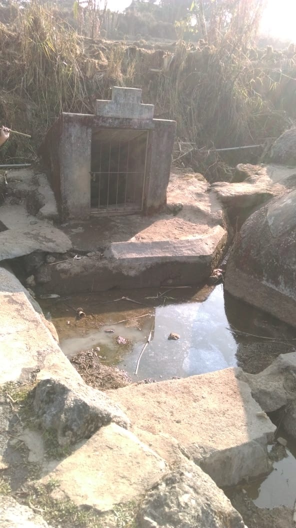
Fig: Spring Chamber and treatment of Catchment Area at Phodlyngdoh.
3. |
Type Of Intervention | Site Name | GPS Co-ordinates | Amount Sanctioned | Work Status | |
|---|---|---|---|---|---|---|
| Spring Chamber and treatment of Catchment Area at Domkhlaw | Domkhlaw | 25.41488 | 91.480778 | Rs.42,450 | Completed | |
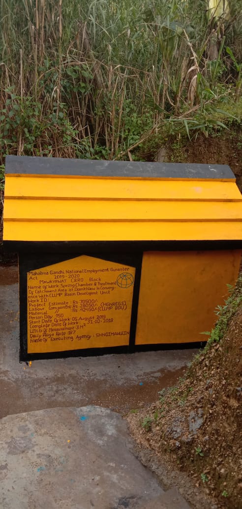
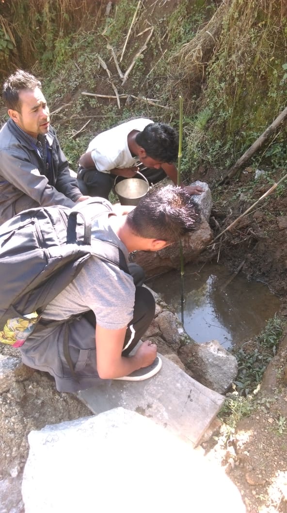
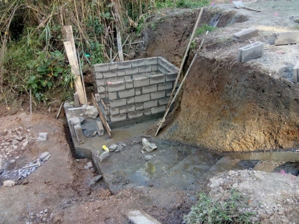
Fig: Spring Chamber and treatment of Catchment Area at Domkhlaw.
| 4. | Type Of Intervention | Site Name | GPS Co-ordinates | Amount Sanctioned | Work Status | |
|---|---|---|---|---|---|---|
| Community Nursery at Lyngdoh | Lyngdoh | 25.4235 | 91.482437 | Rs.2,97,280 | Completed | |
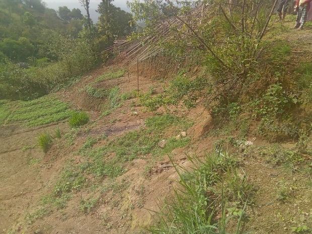
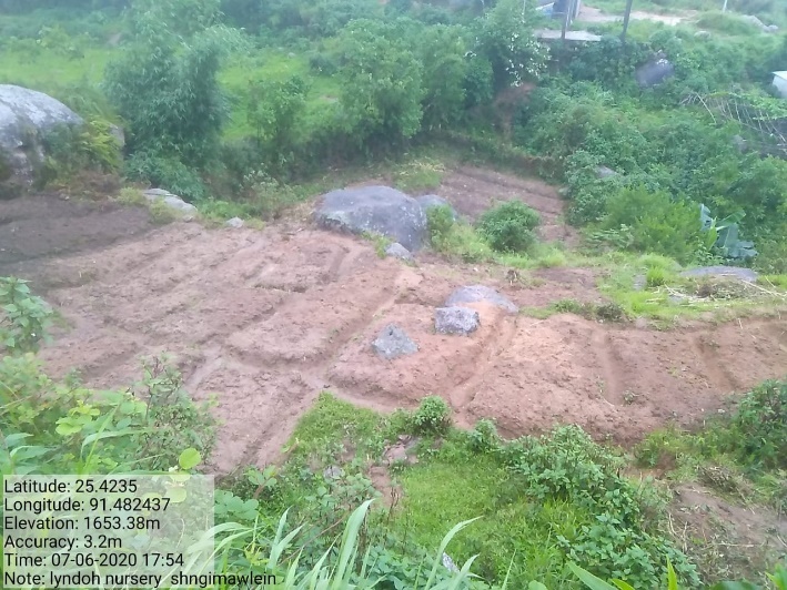
Fig: Community Nursery at Lyngdoh.
5. |
Type Of Intervention | Site Name | GPS Co-ordinates | Amount Sanctioned | Work Status | |
|---|---|---|---|---|---|---|
| Spring Chamber and Treatment of Catchment Areas at Mawjunai | Mawjunai | 25.421218 | 91.481487 | Rs.70,700 | Completed | |
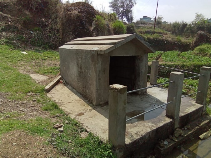
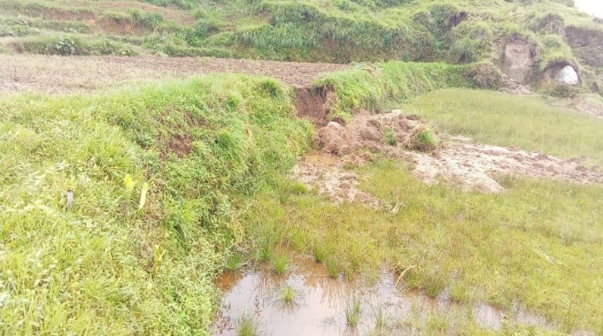
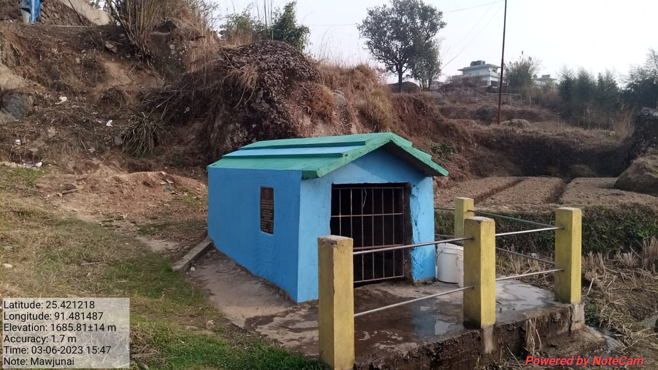
Fig: Spring Chamber and Treatment of Catchment Areas at Mawjunai.
| 6. | Type Of Intervention | Site Name | GPS Co-ordinates | Amount Sanctioned | Work Status | |
|---|---|---|---|---|---|---|
| Spring Chamber and Treatment of catchment areas at Blein Blein. | Blein Blein | 25.419962 | 91.48566 | Rs.76,300 | Completed | |
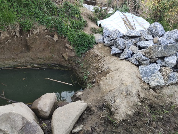
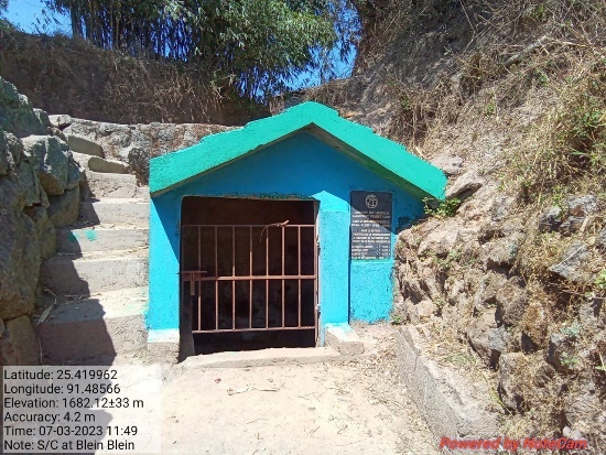
Fig: Spring Chamber and Treatment of catchment areas at Blein
Blein.
| 7 | Type Of Intervention | Site Name | GPS Co-ordinates | Amount Sanctioned | Work Status | |
|---|---|---|---|---|---|---|
| Afforestation at Mawbah-Mawkawan. | Mawbah-Mawkawan | 25.414535 | 91.489292 | Rs.1,73,398 | Completed | |
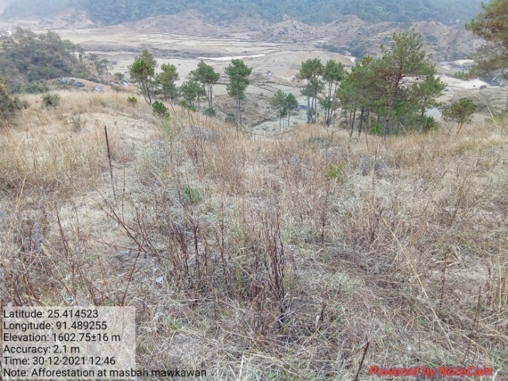
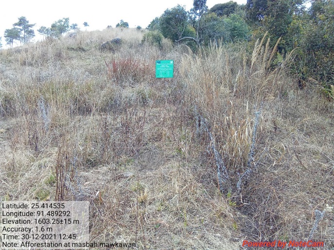
Fig: Afforestation at Mawbah-Mawkawan.
| 8 | Type Of Intervention | Site Name | GPS Co-ordinates | Amount Sanctioned | Work Status | |
|---|---|---|---|---|---|---|
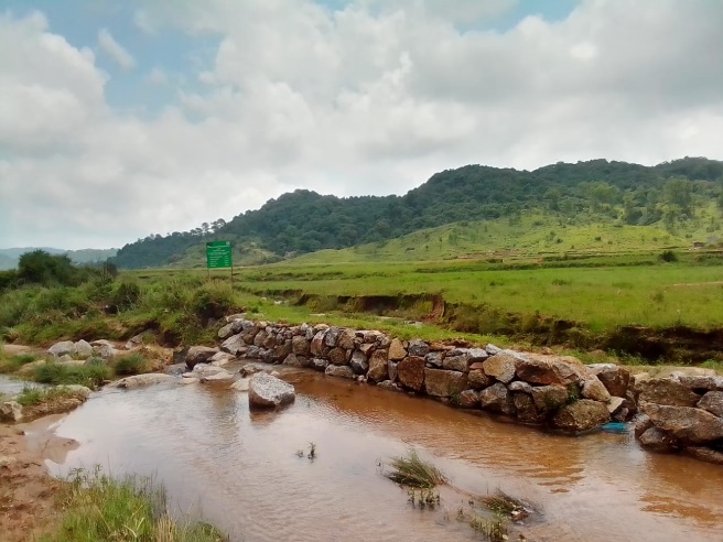
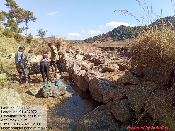
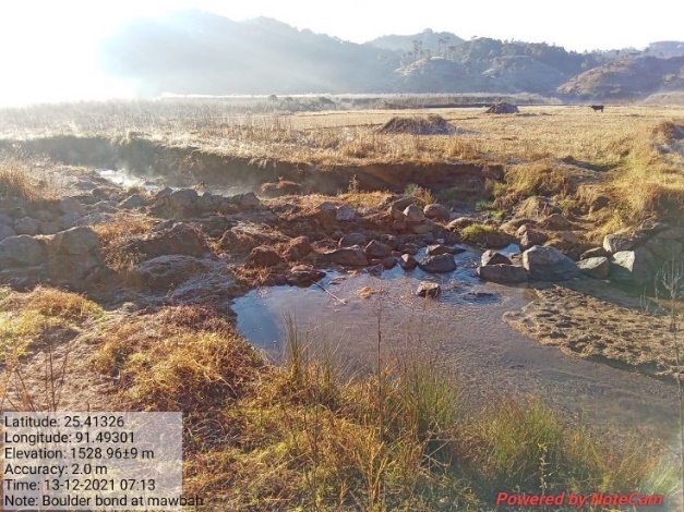
| Boulder Bund at Mawbah. | Mawbah | 25.413217 | 91.492972 | Rs.1,14,141 | Completed | |
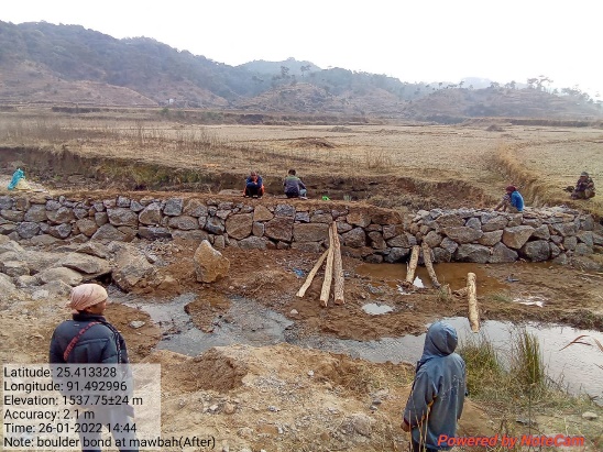
Fig: Boulder Bund at Mawbah.
| 9 | Type Of Intervention | Site Name | GPS Co-ordinates | Amount Sanctioned | Work Status | |
|---|---|---|---|---|---|---|
| Boulder Bund at Mawlwai. | Mawlwai | 25.428324 | 91.48115 | Rs.1,56,135 | Completed | |
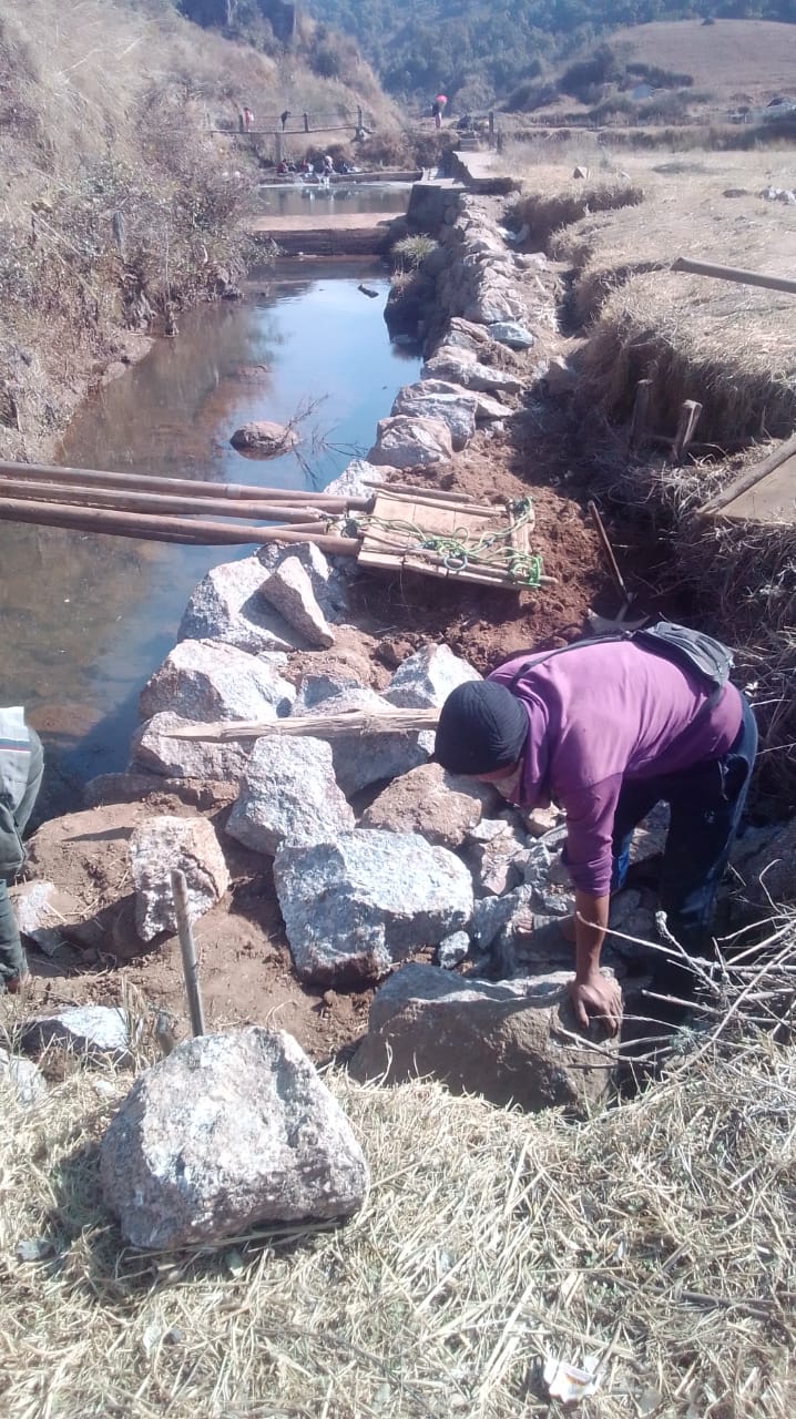
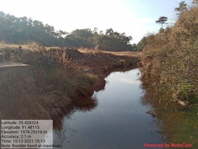
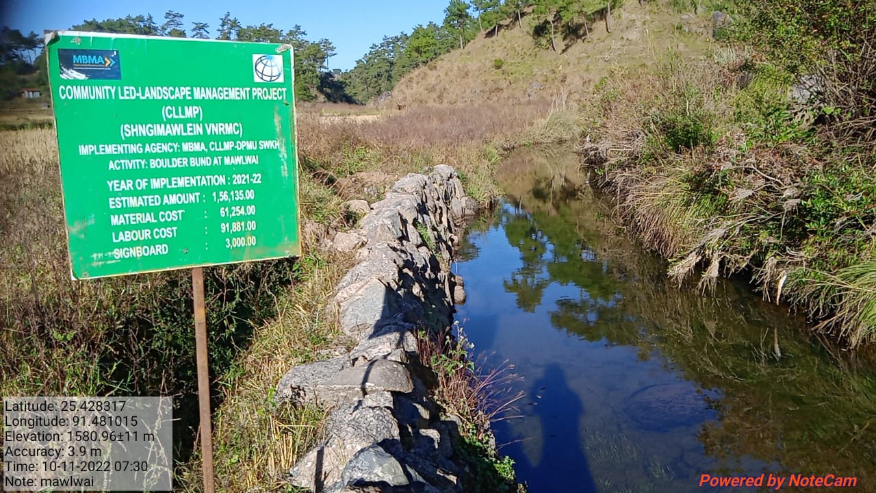
Fig: Boulder Bund at Mawlwai.
| 10 | Type Of Intervention | Site Name | GPS Co-ordinates | Amount Sanctioned | Work Status | |
|---|---|---|---|---|---|---|
| Boulder Bund at Phorbuaid. | Phorbuaid | 25.424237 | 91.485983 | Rs.25,170 | Completed | |
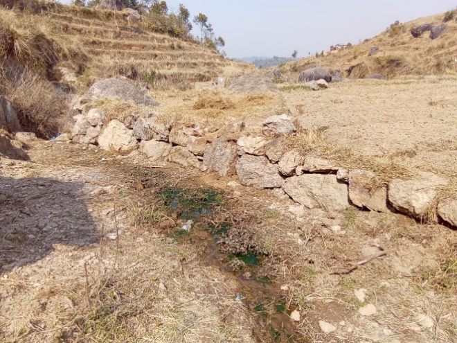
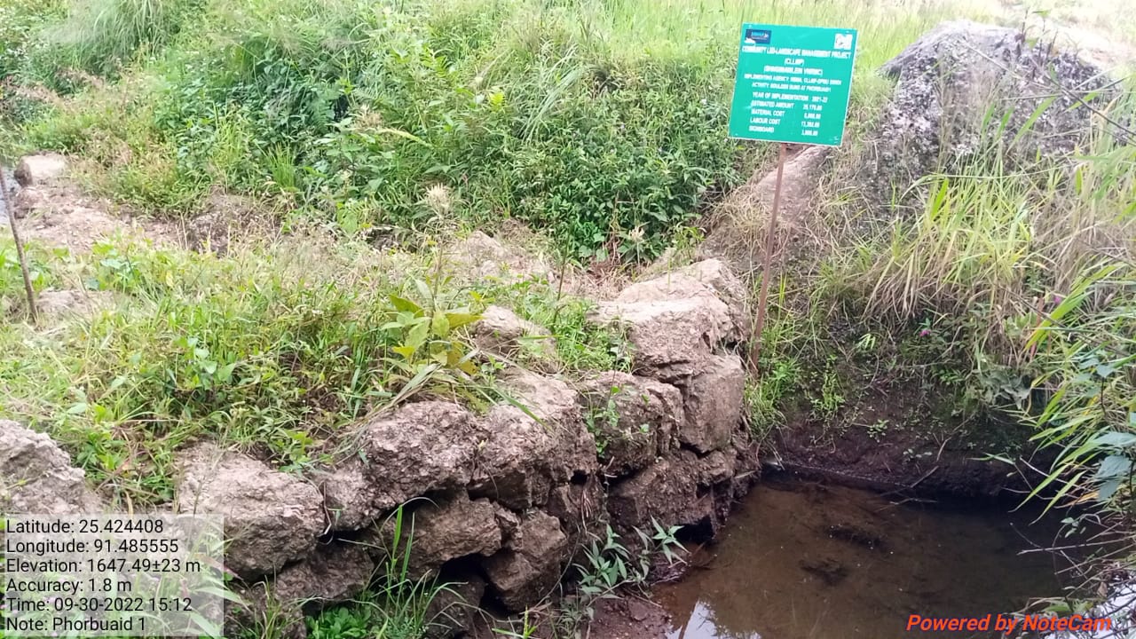
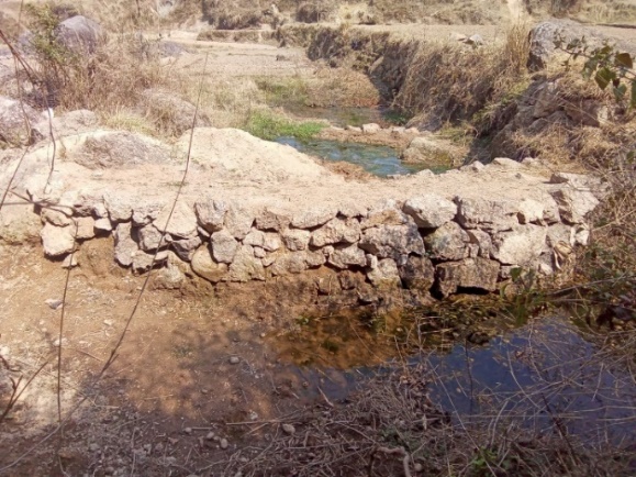
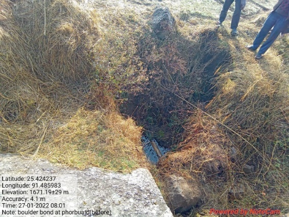
Fig: Boulder Bund at Phorbuaid.
| 11 | Type Of Intervention | Site Name | GPS Co-ordinates | Amount Sanctioned | Work Status | |
|---|---|---|---|---|---|---|
| Boulder bund at Mawkyllein 1 | Mawkyllein 1 | 25.414135 | 91.496359 | Rs.85,761 | Completed | |
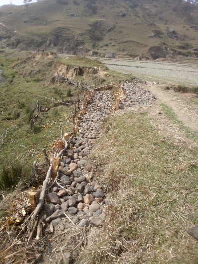
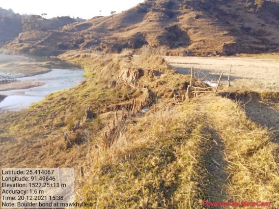
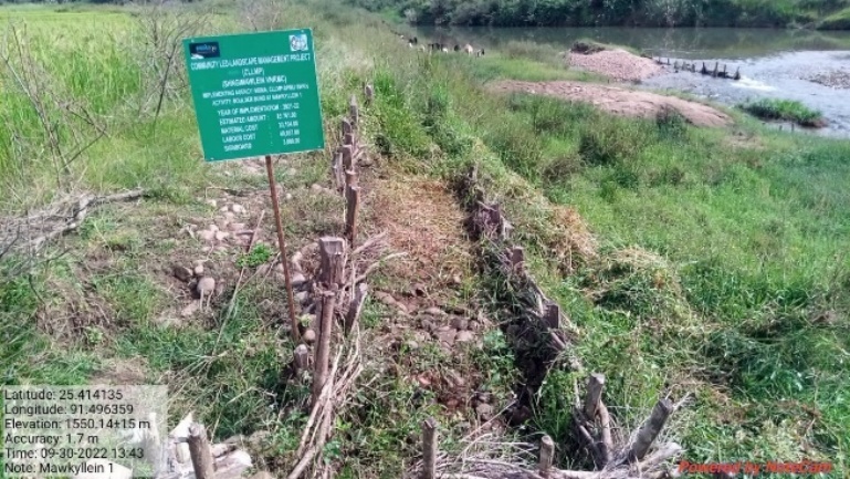
Fig: Boulder bund at Mawkyllein 1.
| 12 | Type Of Intervention | Site Name | GPS Co-ordinates | Amount Sanctioned | Work Status | |
|---|---|---|---|---|---|---|
| Boulder Bund at Mawkyllein 2 | Mawkyllein 2 | 25.4144 | 91.49599 | Rs.92,683 | Completed | |
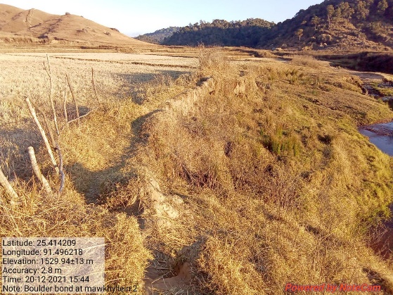
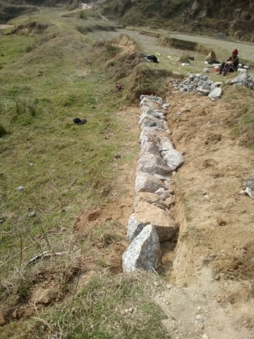
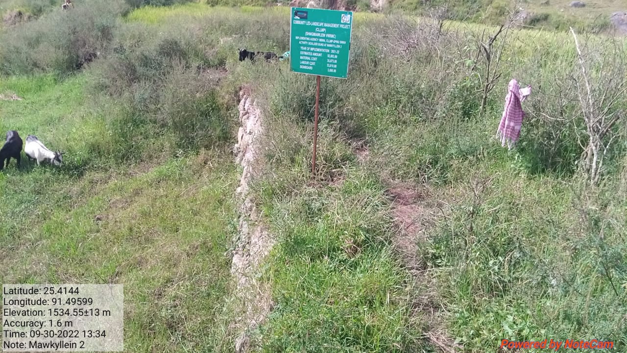
Fig: Boulder Bund at Mawkyllein 2
| 13 | Type Of Intervention | Site Name | GPS Co-ordinates | Amount Sanctioned | Work Status | |
|---|---|---|---|---|---|---|
| Spring Chamber at Nongbah/Liewlong | Nongbah/Liewlong | 25.421827 | 91.484831 | Rs.77,682 | Completed | |
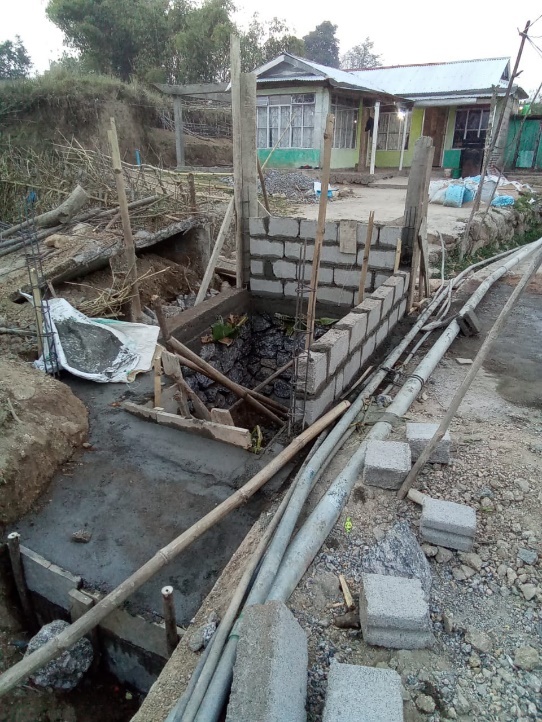
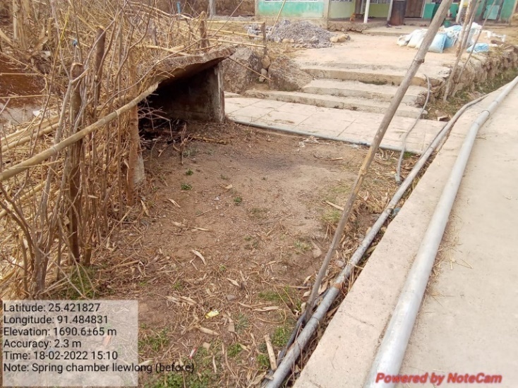
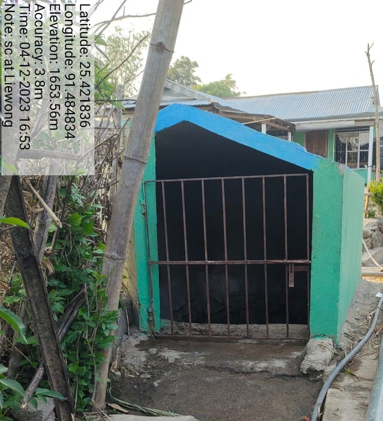
Fig: Spring Chamber at Nongbah/Liewlong.
| 14 | Type Of Intervention | Site Name | GPS Co-ordinates | Amount Sanctioned | Work Status | |
|---|---|---|---|---|---|---|
| Boulder Bund at Phorbuaid 2 | Phorbuaid 2 | 25.42001 | 91.485224 | Rs.55,233 | Completed | |
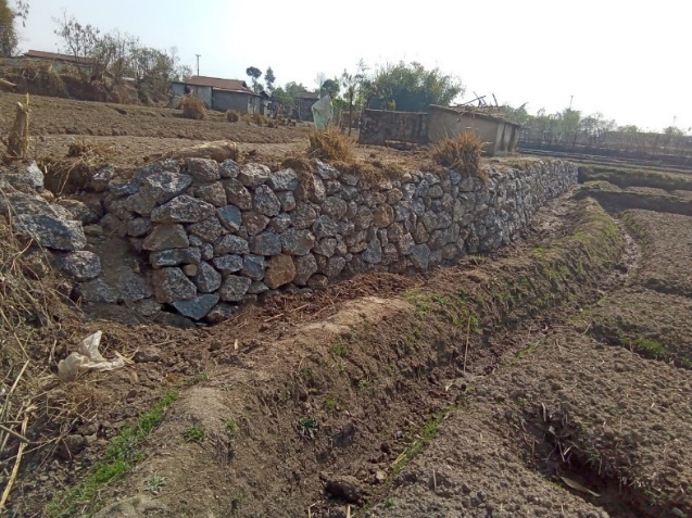
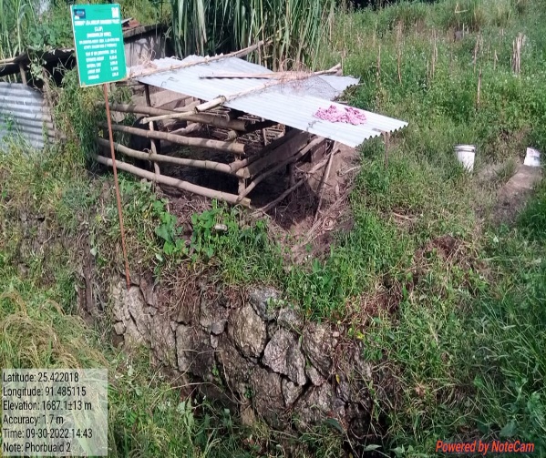
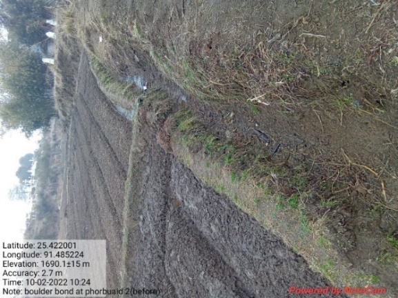
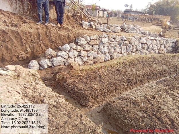
Fig: Boulder Bund at Phorbuaid 2.
| 15. | Type Of Intervention | Site Name | GPS Co-ordinates | Amount Sanctioned | Work Status | |
|---|---|---|---|---|---|---|
| Piping Irrigation cum Water Reserviour Tank at Mawbah | Mawbah | 25.41244 | 91.491587 | Rs.3,69,975 | Completed | |
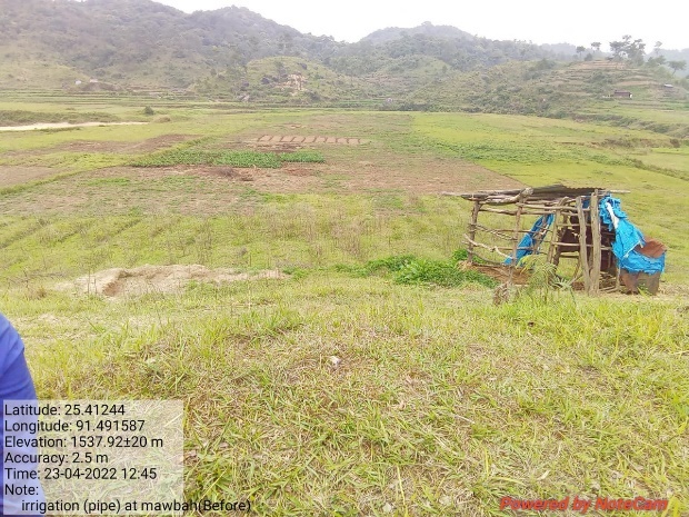
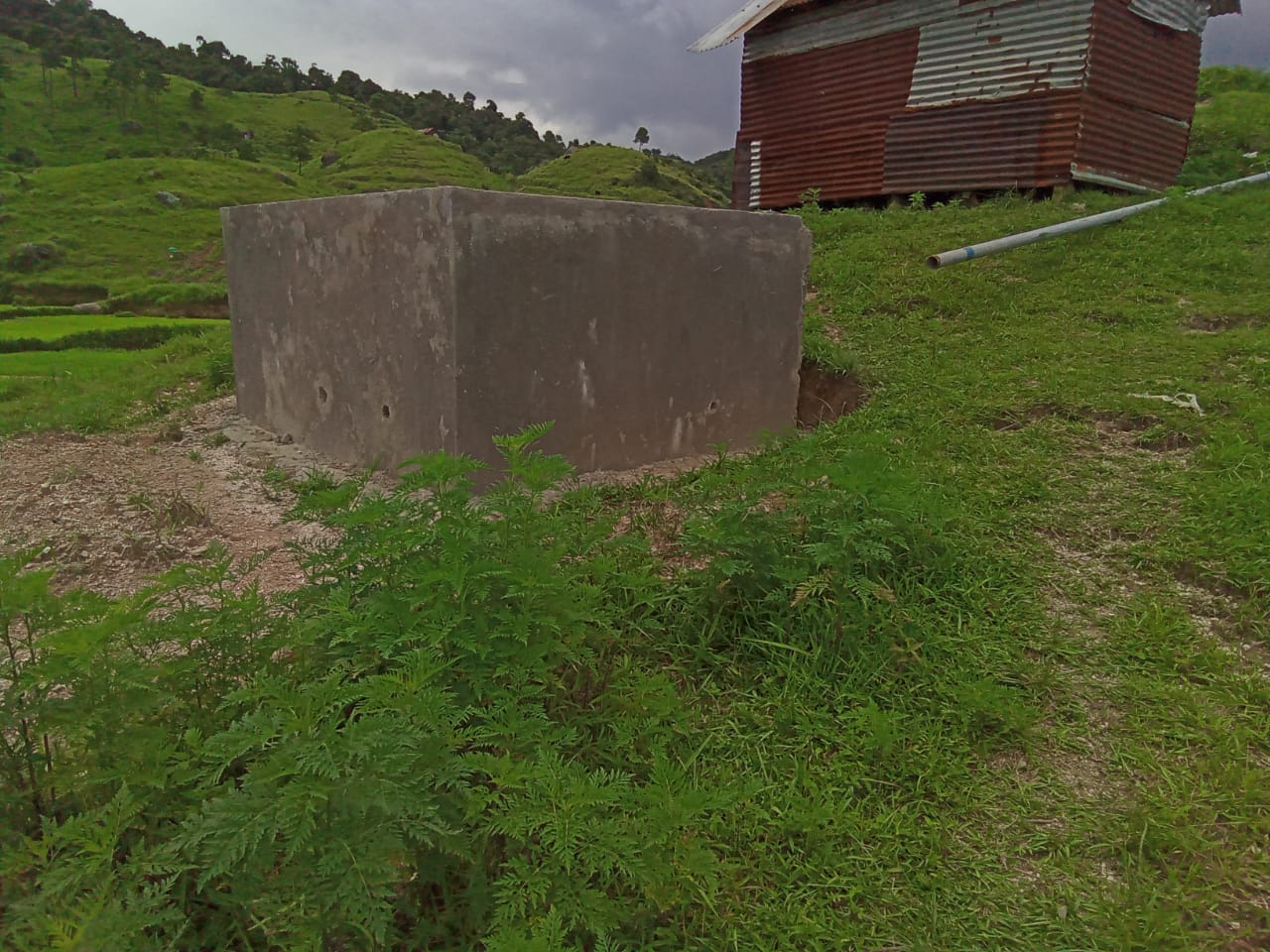
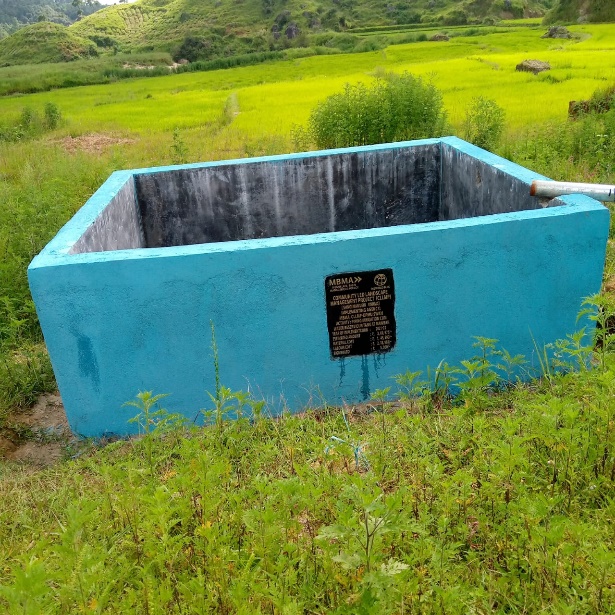
Fig: Piping Irrigation cum Water Reserviour Tank at Mawbah.
16 |
Type Of Intervention | Site Name | GPS Co-ordinates | Amount Sanctioned | Work Status | |
|---|---|---|---|---|---|---|
| Improvement of existing degraded forest at Law Lyngdoh | Law Lyngdoh | 25.431242 | 91.486404 | Rs.1,43,278 | Completed | |
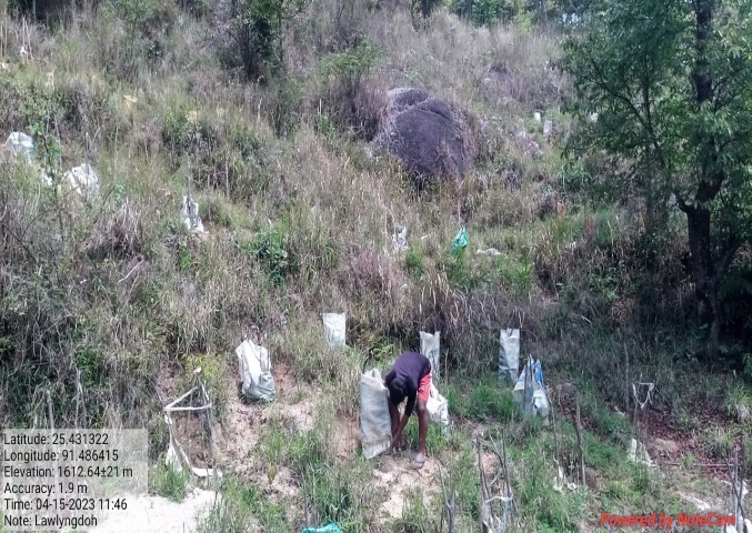
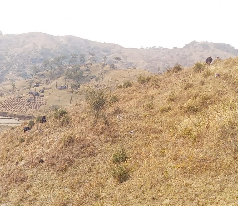
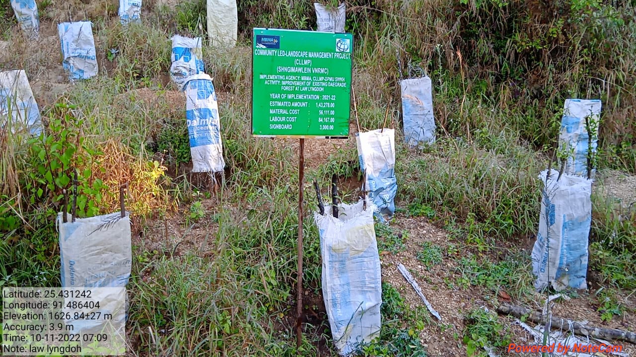
Fig: Improvement of existing degraded forest at Law Lyngdoh.
17 |
Type Of Intervention | Site Name | GPS Co-ordinates | Amount Sanctioned | Work Status | |
|---|---|---|---|---|---|---|
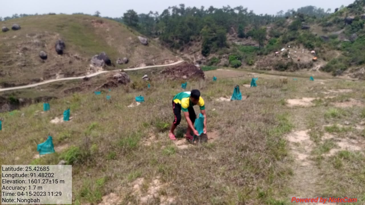
| Afforestation at Nongbah. | Nongbah. | 25.413898 | 91.487745 | Rs.57,124 | Completed | |
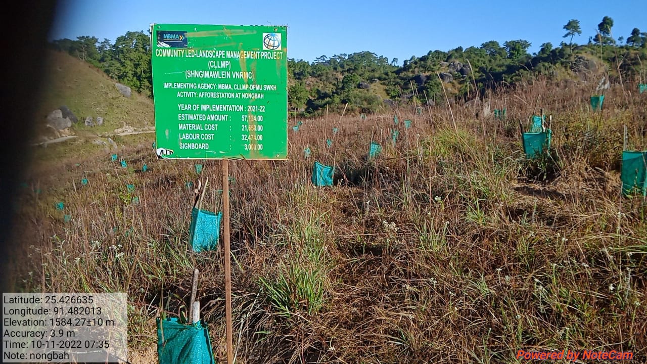
Fig: Afforestation at Nongbah.
| 18 | Type Of Intervention | Site Name | GPS Co-ordinates | Amount Sanctioned | Work Status | |
|---|---|---|---|---|---|---|
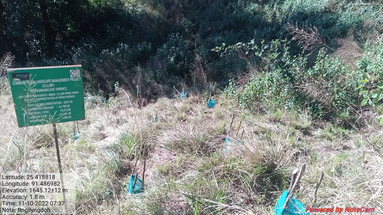
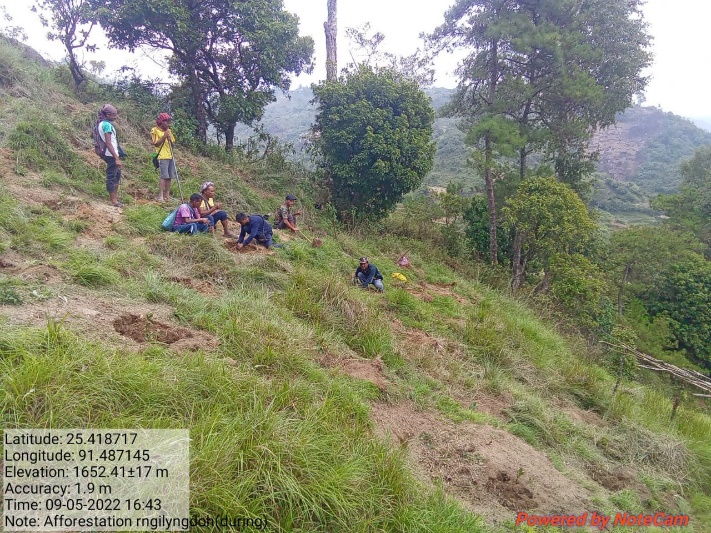
| Afforestation at Rngi Lyngdoh. | Rngi Lyngdoh | 25.418818 | 91.486982 | Rs.41,780 | Completed | |
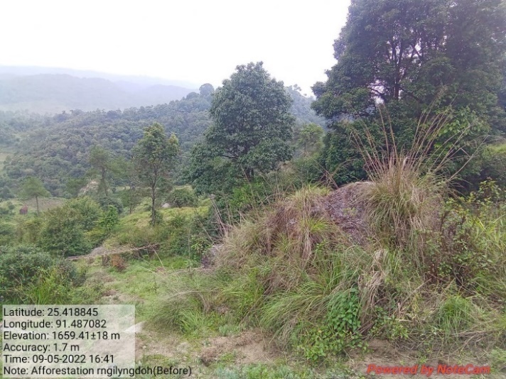
Fig: Afforestation at Rngi Lyngdoh.
| 19 | Type Of Intervention | Site Name | GPS Co-ordinates | Amount Sanctioned | Work Status | |
|---|---|---|---|---|---|---|
| Afforestation at Rngibaniang. | Rngibaniang | 25.420453 | 91.488248 | Rs.22,986 | Completed | |
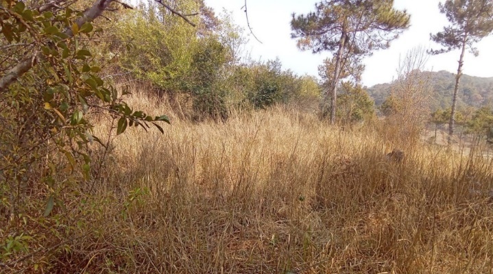
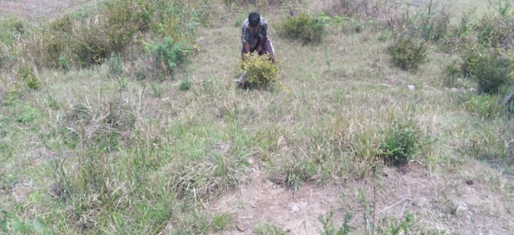
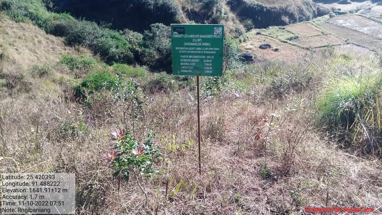
Fig: Afforestation at Rngibaniang.
| 20 | Type Of Intervention | Site Name | GPS Co-ordinates | Amount Sanctioned | Work Status | |
|---|---|---|---|---|---|---|
| Afforestation at Tyngkur. | Tyngkur | 25.414149 | 25.488016 | Rs.88,342 | Completed | |
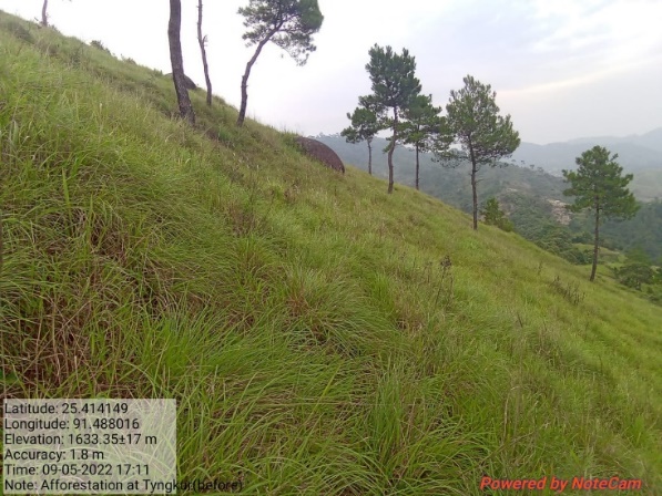
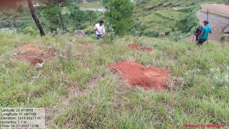
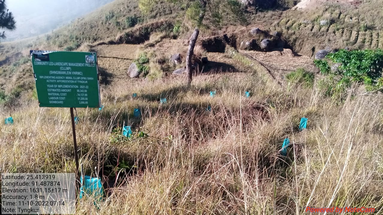
Fig: Afforestation at Tyngkur.
| 21 | Type Of Intervention | Site Name | GPS Co-ordinates | Amount Sanctioned | Work Status | |
|---|---|---|---|---|---|---|
| Boulder Bund at Thangpari. | Thangpari | 25.415799 | 91.496256 | Rs.77,682 | Completed | |
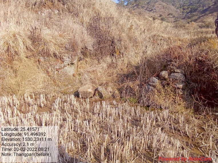
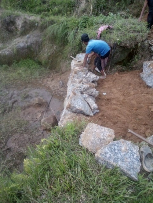
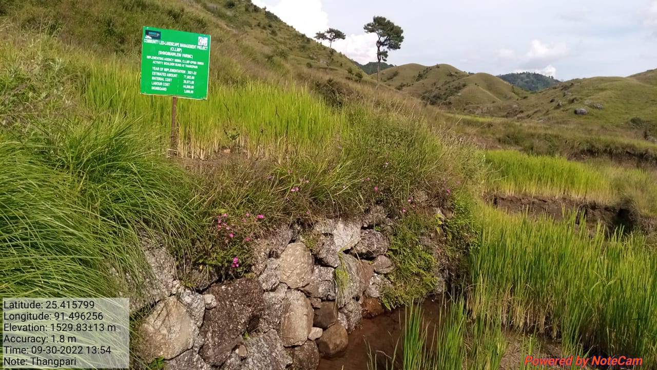
Fig: Boulder Bund at Thangpari.
11.Fund Status:
The fund status for the Rs.21,55,000 are listed in the table below:
Fund Released to VNRMC (Project Implementation)- Rs.21,55,000 Total No. of Work Order Issued- 21 |
|||||
| Activity Name | Amount Sanction | Amount Spent | Work Order Issued Date | Start Date | End Date |
| Spring Chamber & treatment of catchment area at Phorkyntep | Rs.42,450 | Rs. 42,450 | 5th July 2019 | 23rd Sept 2019 | 31st Oct 2019 |
| Spring Chamber & treatment of catchment area at Phodlyngdoh | Rs.44,450 | Rs. 44,450 | 5th July 2019 | 20th Sept 2019 | 31st Oct 2019 |
| Spring Chamber & treatment of catchment area at Domkhlaw | Rs.42,450 | Rs. 42,450 | 5th July 2019 | 5th Aug 2019 | 31st Oct 2019 |
| Community Nursery at Lyngdoh | Rs.2,97,280 | Rs. 2,97,280 | 25th Feb 2020 | 2nd July 2020 | 25th May 2022 |
| Spring Chamber & treatment of catchment area at Mawjunai | Rs.70,700 | Rs. 70,700 | 14th July 2020 | 12th Dec 2020 | 30th May 2021 |
| Spring Chamber & treatment of catchment area at Blein Blein | Rs.76,300 | Rs. 76,300 | 14th July 2020 | 7th Dec 2020 | 30th May 2022 |
| Afforestation at Mawbah-Mawkawan | Rs.1,73,398 | Rs. 1,73,398 | 20th July 2021 | 2nd Aug 2021 | 23rd June 2022 |
| Boulder Bund at Mawbah | Rs.1,14,141 | Rs. 1,14,141 | 22nd Oct 2021 | 13th Dec 2021 | 11th Jan 2022 |
| Boulder Bund at Mawlwai | Rs.1,56,135 | Rs. 1,56,135 | 15th Nov 2021 | 3rd Dec 2021 | 27th Dec 2021 |
| Boulder Bund at Phorbuaid1 | Rs.25,170 | Rs. 25,170 | 18th Jan 2022 | 18th Jan 2022 | 29th Jan 2022 |
| Boulder Bund at Mawkyllein 1 | Rs.85,761 | Rs. 85,761 | 2nd Feb 2022 | 14th Feb 2022 | 19th Mar 2022 |
| Boulder Bund at Mawkyllein 2 | Rs.92,683 | Rs. 92,683 | 2nd Feb 2022 | 14th Feb 2022 | 12th Mar 2022 |
| Spring Chamber at Nongbah/Liewlong | Rs.77,682 | Rs. 77,682 | 2nd Feb 2022 | 21st Feb 2022 | 14th Mar 2022 |
| Boulder Bund at Phorbuaid 2 | Rs.55,233 | Rs. 55,233 | 2nd Feb 2022 | 26th Feb 2022 | 14th Mar 2022 |
| Piping Irrigation Cum Water Reserviour Tank at Mawbah | Rs.3,69,975 | Rs. 3,69,975 | 25th Feb 2022 | 2nd May 2022 | 16th June 2022 |
| Improvement of Existing Degrade Forest at Law Lyngdoh | Rs.1,43,278 | Rs. 1,43,278 | 31st March 2022 | 14th May 2022 | 4th June 2022 |
| Afforestation at Nongbah | Rs.57,124 | Rs. 57,124 | 31st Mar 2022 | 17th May 2022 | 2nd June 2022 |
| Afforestation at Rngilyngdoh | Rs.41,780 | Rs. 41,780 | 31st Mar 2022 | 28th April 2022 | 12th May 2022 |
| Afforestation at Rngibaniang | Rs.22,986 | Rs. .22,986 | 31st Mar 2022 | 28th April 2022 | 30th April 2022 |
| Afforestation at Tyngkur | Rs.88,342 | Rs. 88,342 | 31st Mar 2022 | 16th May 2022 | 15th June 2022 |
| Boulder Bund at Thangpari | Rs.77,682 | Rs. 77,682 | 31st Mar 2022 | 13th April 2022 | 5th May 2022 |
12. GROUND TESTIMONIALS:
5
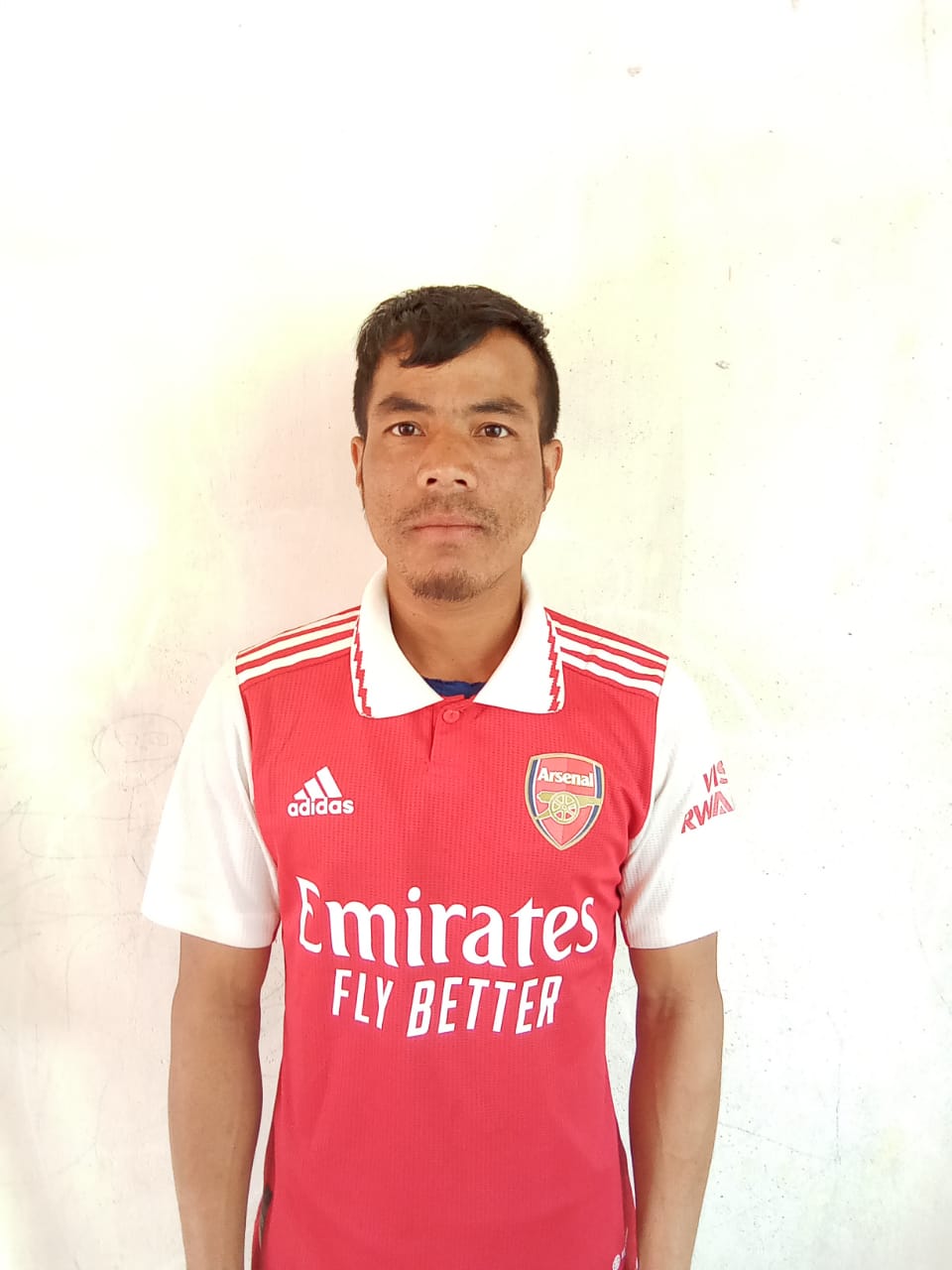
Mr. Lokkistar Mawlong
VCF Shngimawlein
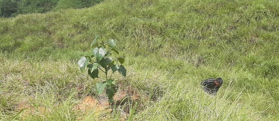
According to Mr. Lokkistar Mawlong he said that since the Community Led Landscape Management Project was implemented, they have indeed benefited from it in the length and breadth of their village. We have received Spring Chambers from this Project in every locality within our village and this has indeed helped the people during the dry season. In many areas which have no vegetation and left barren for many years they have now seen the young tree sapling because of the afforestation implemented by the office. I have also received trainings related with NRM through this office.
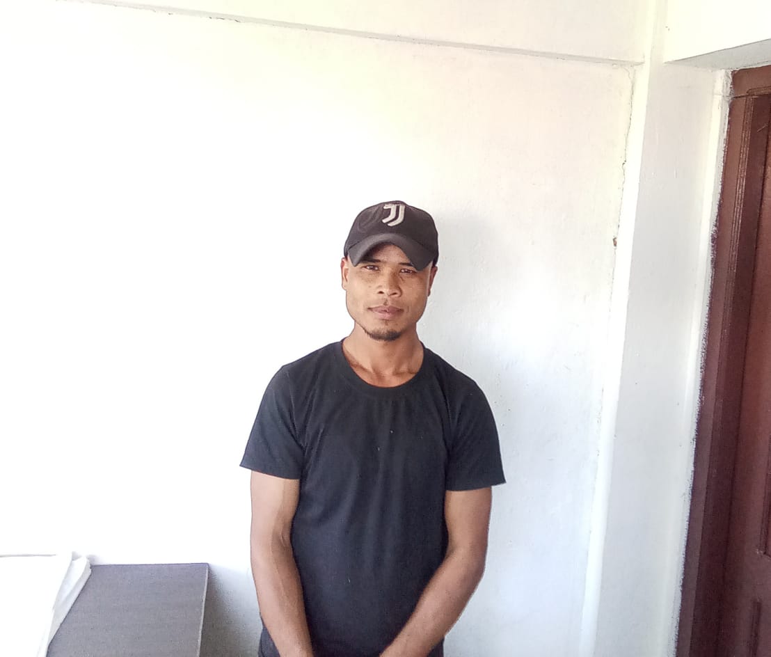
Resparland Lyngkhoi
VCF M&E
First and foremost, Mr. Resparland Lyngkhoi would like to thanked the DPMU CLLMP South West Khasi Hills for all the works that have benefited their village and all the staff that had support them in every step of the way. As a VCF I have always take my chance to learn new things, and being with CLLMP has taught me not only how to write, update and maintain the book of records such as the purchase register, cheque issue register, payment voucher, etc. but I have also learned to test the quality of the water, calculate the spring discharge, or the pH of the water. I had also attended training on Seed-Ball Making and I would have not known about all these if it was not because of my interest in gathering more knowledge and the esteemed office that had provided me with such a space to learn.
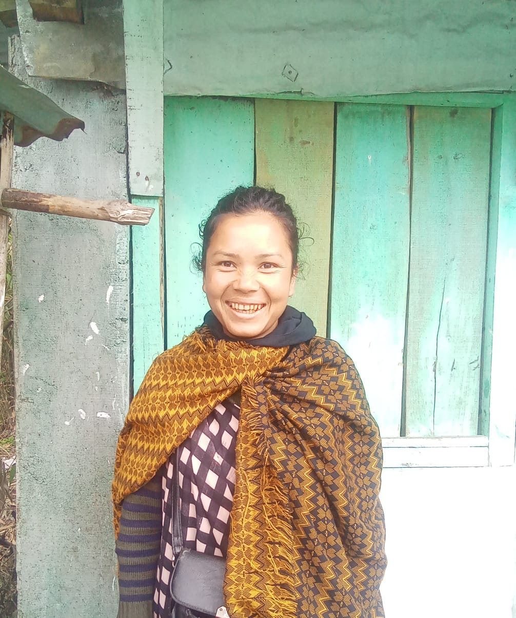
Balari Lyngkhoi
Secretary VNRMC
I am thankful to have had the opportunity to learn and grow with this office. I have gained a lot of experience throughout the years as a secretary in the VNRMC. Seeing that this office aimed at conserving our forest, land and water, it helps us to also be aware and teach our children the importance of our surrounding.
Mr.Khlingdar Wahlang
President Shngimawlein VNRMC
“I am very grateful to the DPMU CLLMP South West Khasi Hills District for their guidance since the commencement of this Project in our village. We have indeed benefitted from this Project in many ways whereby, the beneficiaries have also expressed their gratitude as their lands that have once been barren, are now blessed with the intervention such as afforestation and in areas whereby erosion is a frequent occurrence, have received boulder bunds to prevent erosion of the soil in their Paddy areas.”
_________________________________************************____________________________