TABLE OF CONTENTS

 1.
Village Overview
1.
Village Overview
- Interpretation
 ACTIVITIES
1.
Sensitization & Ground Truthing
 2.
Formation of VNRMC
2.
Formation of VNRMC
3.
Opening of Bank Account 4. Participatory Rural
5.
PRA Exercise
Village Boundary Map
Community Led Landscape Management Project
The Government of Meghalaya with financial aid from the World Bank is implementing the Meghalaya Community Led Landscape Management Project (MCCLMP). The project will cover the entire state of Meghalaya and implementation of community led plans will be rolled out in a phase manner throughout the state. The Meghalaya Basin Management Agency (MBMA) will facilitate community-led planning by providing support, technical inputs and funding.
The project is intended to strengthen community-led natural resources management in selected landscapes within the 7 districts of the state. This would be achieved through a variety of planning, capacity building, and on-the-ground interventions to promote the conservation, sustainable use of natural resources, social inclusion and community mobilisation; building traditional knowledge and learning, mapping of natural resources management; strengthening the community institutions and creating linkage with financial institutions and community organisations.
The project interventions will include preparation of community led natural resource management plans. The CLLMP has the following three components:
Strengthening Knowledge and Capacity of Communities for Natural Resources Management
Community-Led Landscape Planning and Implementation
Project Management and Governance
The project objective is “to manage and conserve the natural resources, especially forests, soil and water sources, in a manner that supports the financial and physical well-being of communities in the State”
Village Overview
Thaiñthynroh Mawlum village falls under Mawphlang C&RD Block of East Khasi Hills in the state of Meghalaya. The village is situated 12km away from sub-district headquarter Mawphlang and 36km away from district headquarter Shillong.
According to Census 2011 information Thainthynroh Mawlum has a total population of 780 peoples. There are about 144 houses in Thainthynroh Mawlum village. Mawphlang is nearest town to Thainthynroh Mawlum.
First Contact
The first contact with Thain Thynroh was established with the headman of the village Bah Win on the 4th September 2019. Ground truthing was also done on the same day. Some of the findings after discussion with the headman and ground truthing were:
The village is rural.
VEC is actively performing in the village.
A total of 186 household are present in the village.
Findings
Traditional and Indigenous Practitioners in the Village people
The village still has traditional healers and traditional dance performers.
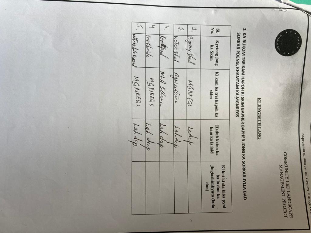
Various Government Schemes availed in the village
Mahatma Gandhi National Rural Employment Gaurantee Act
MLA scheme
MDC scheme
Indigenous Food available
Wild Vegetables (Yam,Sweet Potato, Corn and Potato (phansaw) etc.
Putharo
Women Participation in the Village
Allowed to attend the village Dorbar
Allowed in the decision making process of the Dorbar
Executive committee of Village Employment Committee
Challenges faced by the people in the village
Foot path
Water scarcity
Low income
Lack in modern practice in agriculture
Numbers of CBO/ SHGs/ CLUBS in the Village
3 Self Help Groups
1 Youth Club
1 women’s wing
Activities Carried out in the Village
Cleaning Drive
Dorbar committee in protection of forest fire
Traditional dance
Number of Fair price shop
1 FPS
Prices of essential Commodities
Rice ₹3 /- per Kg ( PHH & AAY )
Kerosene ₹40/- per litre
Sugar ₹100 3kg
Flour 5kg per card
Amount of Kg/ Liter received for each Commodity
Rice 5kg per household
Sugar 3kg per household
Flour 5kg per card
Kerosene 2 litres
Type of Ration Cards
Priority Household (PHH) Card
Antyodaya Anna Yojana (AAY) Card
Inflow of Resources
Sugar
Rice
Kerosene
Flour
Farming methods practiced in the village
Traditional Farming Practices
Types of Fertilizers
Cow dung
Marketability of Crops
Once a week
Distance to the Market
Shillong 28- 38 km
Mode of transport: Local transport (local taxi and sumo)
Daily Wage
₹280 for male
₹200 for female
Seasonal crops cultivated
Mustard leaf
Potato
Radish
Cabbage
Peas
Chilli
Number of Local Market & Frequency
Daily
Market Authority
Syiemship
Taxation in the Local Market
Yes
Loss of income due to constant bargaining
LAND USE PATTERN
Land Ownership
Community
Private
Hima
Land usage
Farming
House and business
Natural Features of the Land
Mountains and Hills
Flat grassy Areas
Tress and other vegetation
Ponds, streams and rivers
Resources present in the Land
Natural resources
Natural and Man-made Disasters
Landslides
Flora and Fauna
Indigenous birds (Sim Syiem).
Ier khia and Deer
Major trees in the Village
Dieng sai
Dieng snium
Trees that helps in Spring Discharge
Dieng Sohplum
Dieng Sohphie
Lakait
Kseh Bilat
Sharing Of catchment Areas with other villages
No
WATER SOURCES
Main Source of Water
Public tab
Main source of Drinking Water
Public tab/ PHE
Distance of water sources (in meters)
3 metres
Time taken to fetch water (in minutes)
1-2 minutes
Frequency of water supply
24 hours
Is the frequency sufficient
Yes
Quality of the water
Excellent
Colour of the water
Clear
Water Scarcity months
March – May
Is water source well maintained?
Yes
Satisfaction of drinking water supply
Satisfied
ENVIRONMENT
Availability of traditional environmental protection beliefs
No
Waste management system
No
Is Deforestation practice in the village
Yes, only for domestic purposes
Is Afforestation practice in the village
Yes, once a year
Interpretation
Traditional and Indigenous Practitioners in the Village people
Traditional healers and dance performers are still present in the village. The people rely on the practice of traditional healing if the need is urgent and the reason to the presence of traditional practices is because they are cost effective. In major cases, people do refer themselves to hospitals. This tells about the importance of these practitioners in the village.
Government Schemes availed in the village
Major schemes like MGNREGA, MLA and MDC schemes are the most active in the village in terms of regularity and services. These schemes are used by the villagers to improve their overall well-being in the village. The study interprets that the population of the village are highly dependent on schemes and services provided by the Government.
Indigenous Food available
The village has some sources of indigenous food that’s have been practice by their ancestors and has continued till today in the present generation. Some of these food are Phankaro, Shriew, Riewhadem and Phansaw.
Women Participation in the Village
Through the baseline study, the village shows equal participation of women which constitutes of about 95% of their participation and are also included in the decision making process of the Dorbar.
Problems and Challenges faced by the people in the village
There are numerous problems in the village but the FGD identified three important issues:
Lack of proper footpath in the community.
Low income and water scarcity.
Lack of modern practice in agriculture.
Numbers of CBO/ SHGs/ CLUBS in the Village
The village is constituted of 1 youth groups and 3 Self Help Groups and 1 women’s wing. All of them are functioning actively and act as contributors to the well-being of the village. The existence of diverse groups shows that the village has a strong participation from its members.
Land use Pattern
The landholdings shows that land is equally owned by the Community, Private and Raid/Hima. In terms of natural features of the village consists of mountains, hills, flat grassy areas, streams and rivers.
The types of trees are found in large number are primarily 3 types are those that help in spring discharge.
Water Source
From the findings, it can be interpreted that the villages receive an abundant and frequent supply of water. They expressed their satisfaction with the frequency of water supply which is 24 hours and the quality since the water is clear in colour, but there is a water shortage form the month of March to May.
Environment
The villages understand the importance of conserving the forest and its resources. In terms of protecting the environment they shared that the trees are planted once a year but there are also wild ones that grows at their own pace. The village practice both deforestation and afforestation, but deforestation only happens for domestic purposes. They do not have any traditional methods or practices in protecting the environment or neither do they practice any modern method of waste management.
Activities
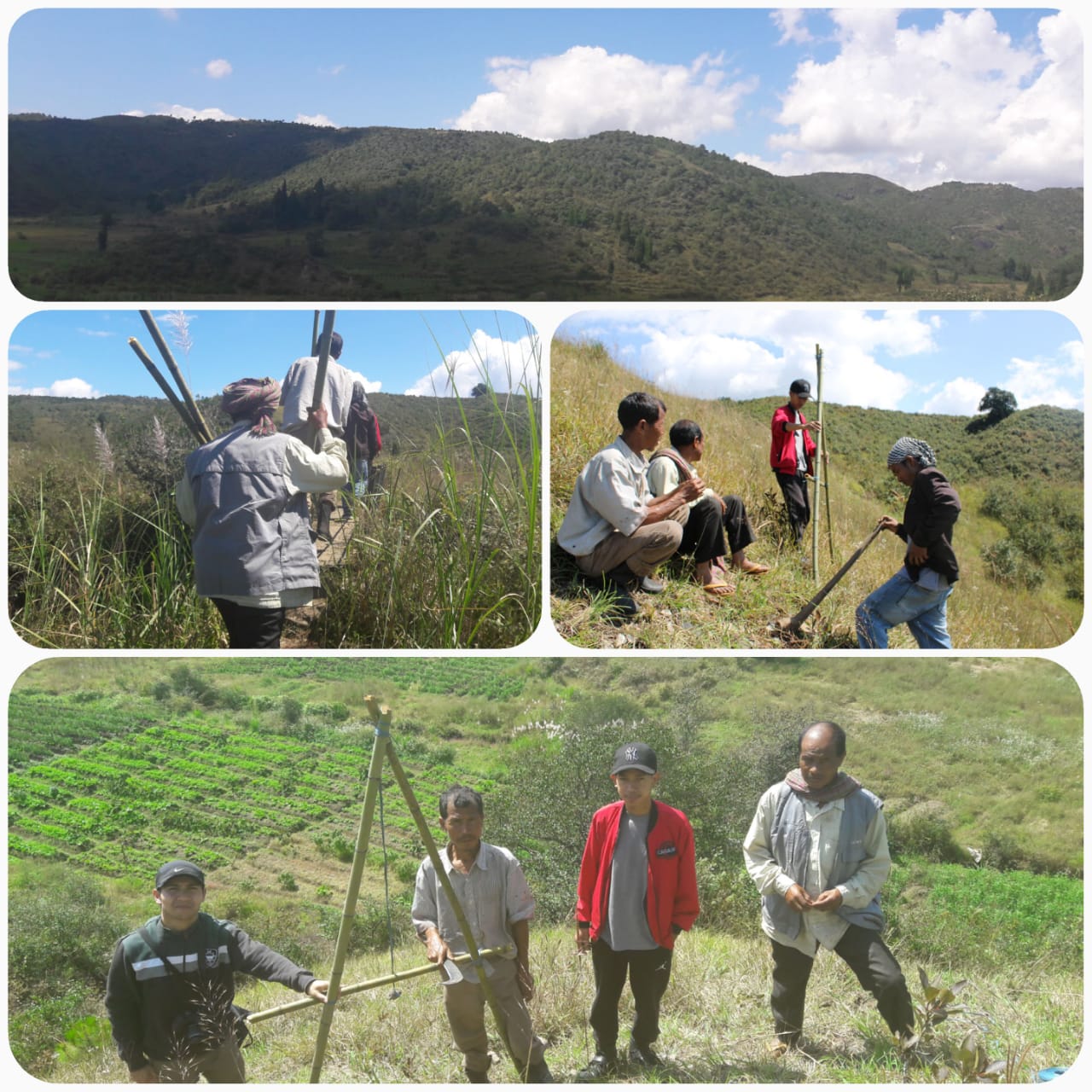
Sensitisation Programme & Ground Truthing
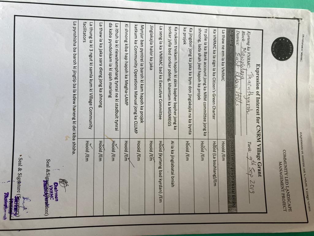
The first sensitisation programme was conducted on 4th September 2019 in the Community Hall of the village. The programme was presided over by the headman of the village. Approximately 40- 50 residents attended the sensitisation programme. The ADPM of East Khasi Hills, Mr. Pynshngain Rymmai gave an introduction to the Community Led Landscape Management Project (CLLMP) and its various nuances that the community and the CLLMP team should carry out throughout the course of the project. The first priority was establishing of the Village Natural Resource Management Committee (VNRMC) and thereafter formulation of the Community Natural Resource Management Plan (CNRMP) was to be prepared.
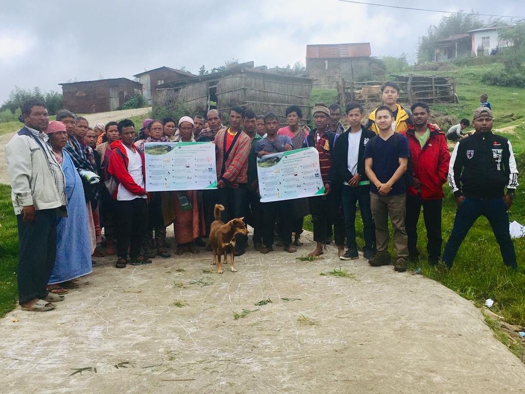
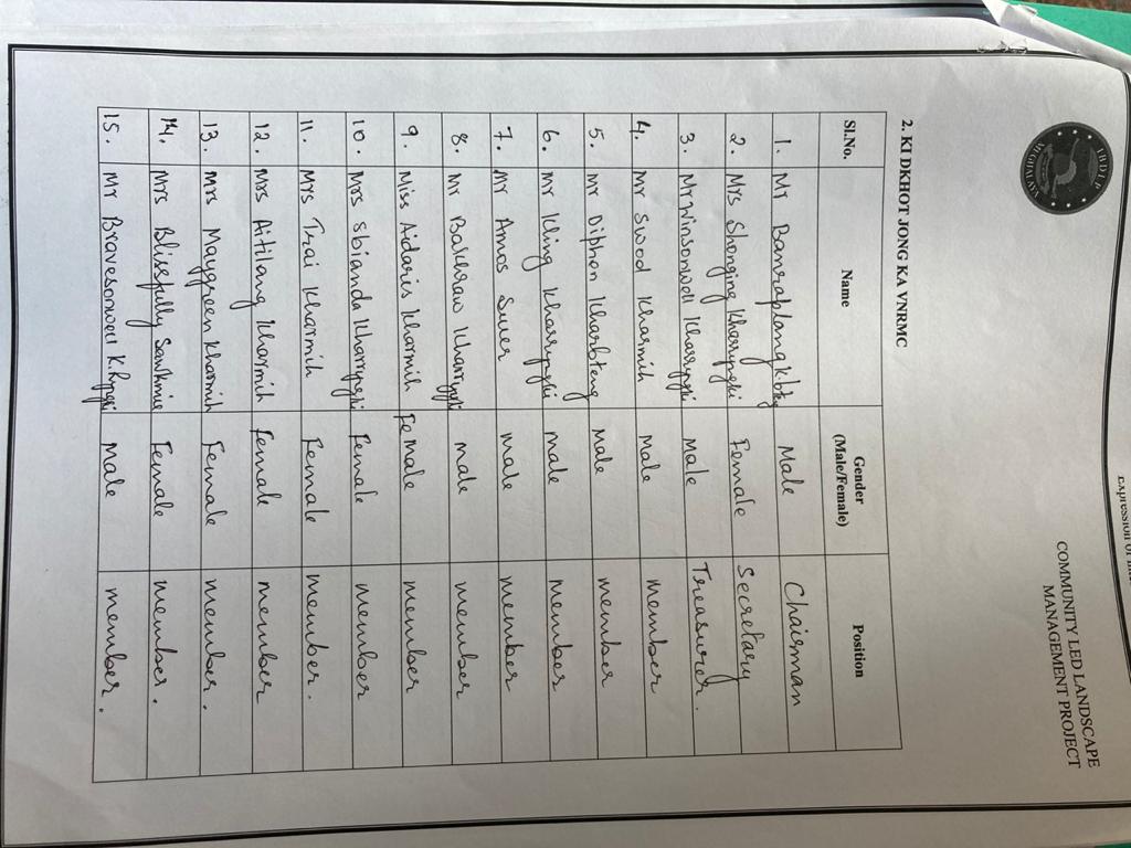
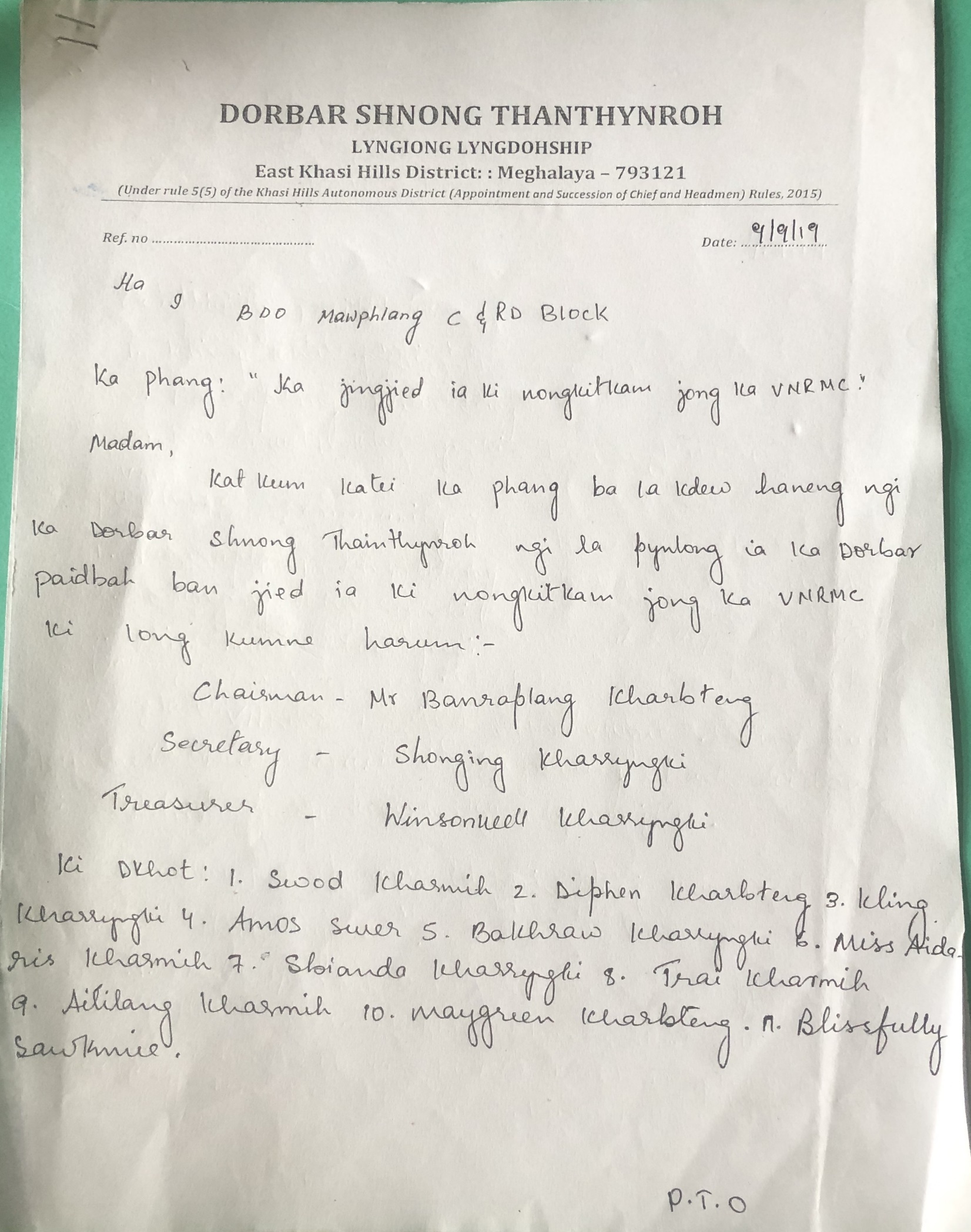 Formation of
VNRMC
Formation of
VNRMC
 The executive committee
of the Dorbar Shnong of Thaiñthynroh Mawlum after a meeting formed
the members of VNRMC on the 9th of September, 2019. On
the 9th of September, the DPMU members visited the
village again for the signing of the EOI, VGA and Citizen’s Green
Charter and the executive members of the VNRMC were formally
introduced
The executive committee
of the Dorbar Shnong of Thaiñthynroh Mawlum after a meeting formed
the members of VNRMC on the 9th of September, 2019. On
the 9th of September, the DPMU members visited the
village again for the signing of the EOI, VGA and Citizen’s Green
Charter and the executive members of the VNRMC were formally
introduced
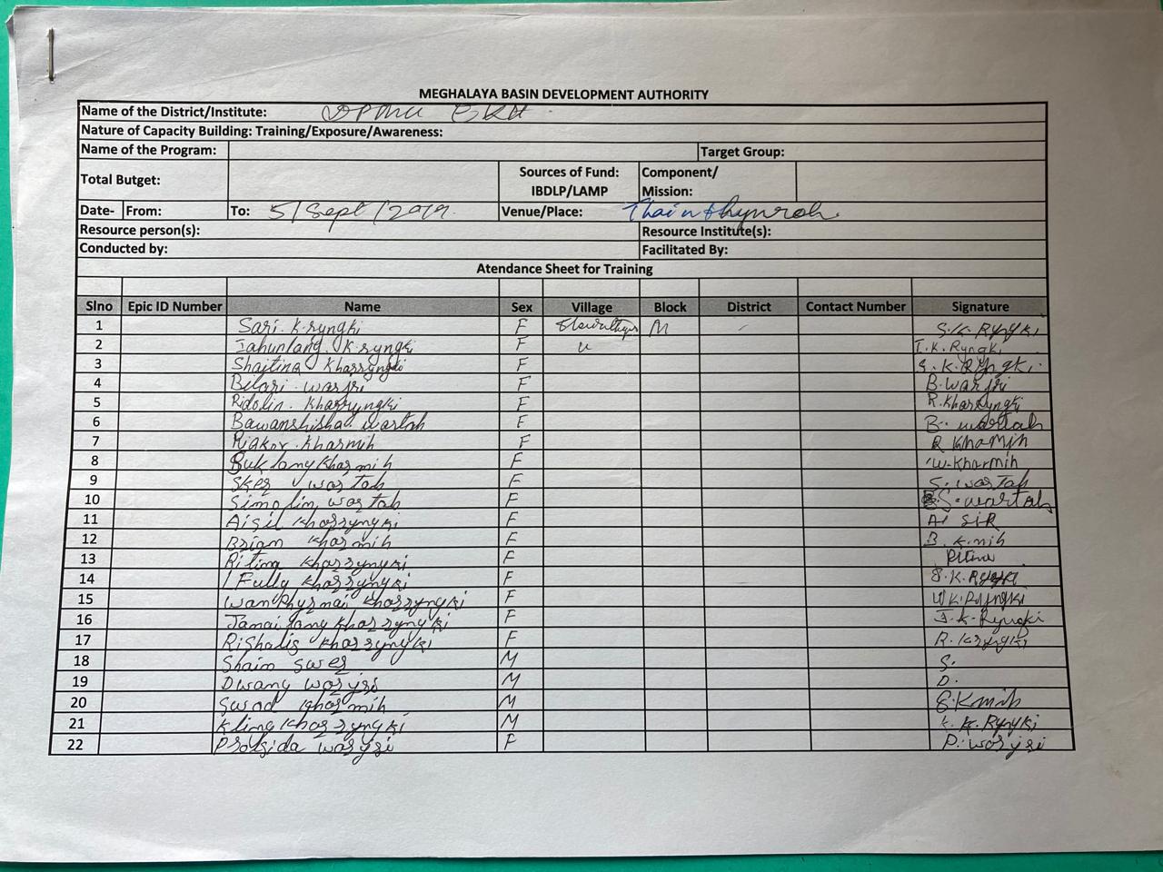
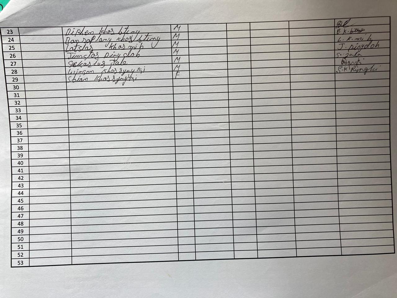
| Sl No | Name in Full | Gender M/F | Age (in Yrs) | Education | Designation | Occupation | Community | Contact No and email address |
|---|---|---|---|---|---|---|---|---|
| 1 | Banraplang Kharbteng | Male | 33 | IV | Chairman | Business | Khasi | 9366942038 |
| 2 | Shonging Kharryngngi | Female | 45 | x | Secretary | Teacher | Khasi | NA |
| 3 | Winsonwell Kharryngki | Male | 32 | VII | Treasurer | Farmer | Khasi | 6009657977 |
| 4 | Swod Kharmih | Male | 50 | vi | member | Business | Khasi | NA |
| 5 | Diphen Kharbteng | Male | 52 | vi | member | Farmer | Khasi | NA |
| 6 | Kling Kharryngki | Male | 50 | iv | member | Labourer | Khasi | NA |
| 7 | Amos Swer | Male | 35 | iv | member | Farmer | Khasi | NA |
| 8 | Bakhraw Kharryngki | Male | 65 | viii | member | Labourer | Khasi | NA |
| 9 | Aidaris Kharmih | Female | 25 | x | member | Business | Khasi | NA |
| 10 | Sbianda Kharryngki | Female | 55 | vi | member | AgaNWADI | Khasi | NA |
| 11 | Trai Kharmih | Female | 47 | ii | member | Farmer | Khasi | NA |
| 12 | Aitilang Kharmih | Female | 35 | viii | member | Farmer | Khasi | NA |
| 13 | Maygreen Kharbteng | Female | 43 | viii | member | Farmer | Khasi | NA |
| 14 | Blissfully Sawkmie | Female | 25 | MA | member | Teacher | Khasi | NA |
The opening of bank account was initiated after the village signed the EOI (Expression of Interest), VGA (Village Grant Agreement) and the Citizen’s Green Charter. Thain Thynroh opened their bank account on the ______________
____________________Programme Associate (Finance and Procurement) of East Khasi Hills, CLLMP, conducted the Simple Book Keeping Training on 29thOctober 2019, at Thain Thynroh village
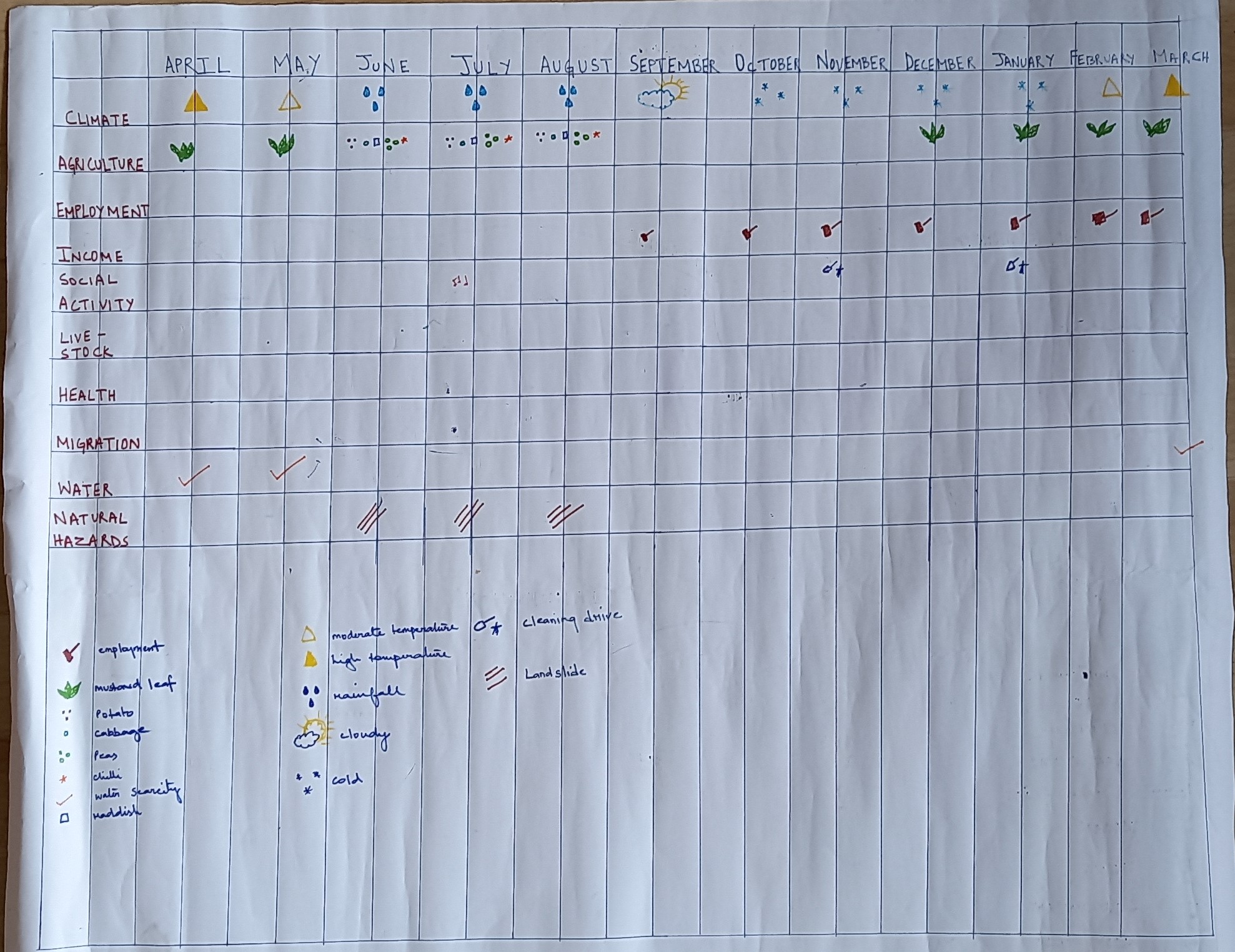
The Participatory Rural Appraisal exercise aims to incorporate the knowledge and opinions of the community in the planning and management of development projects and programmes. PRA exercise at Thain Thynroh was conducted on the 5thSeptember, 2019. There was a total of 30 residents who took part in this exercise.
Findings:
Most of the land is community owned
Main agriculture produce here are Yam, Sweet Potato, Corn and Potato.
The average daily wage for men is Rs.250 and for women is Rs.200
The village receive adequate amounts of water supply except in the months of March and April where they encounter water scarcity.
Most of the land in the village is use for farming and business purposes.
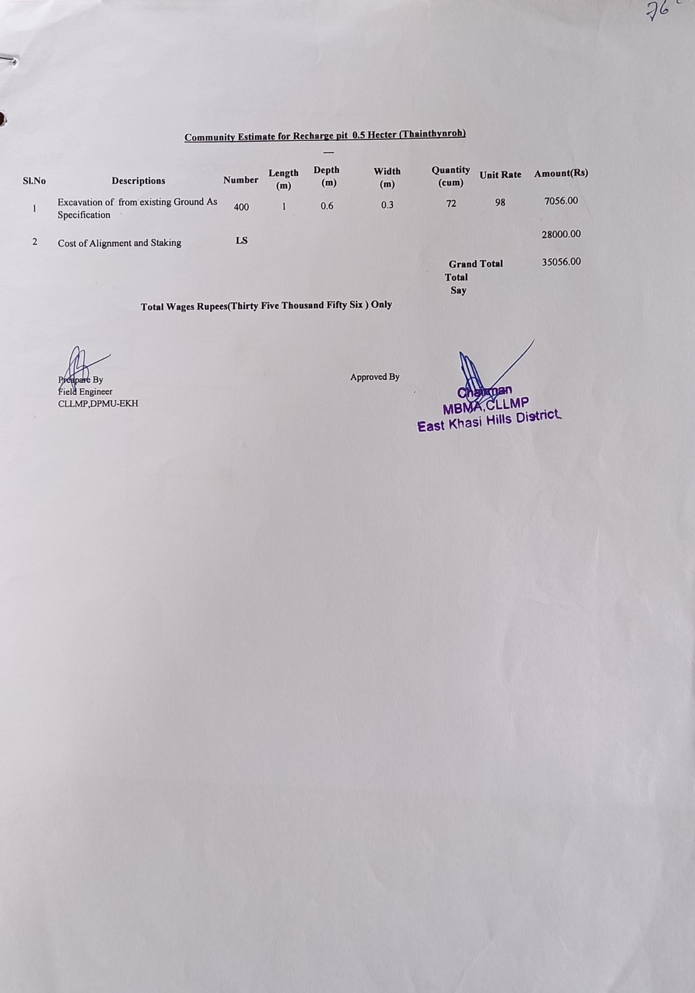
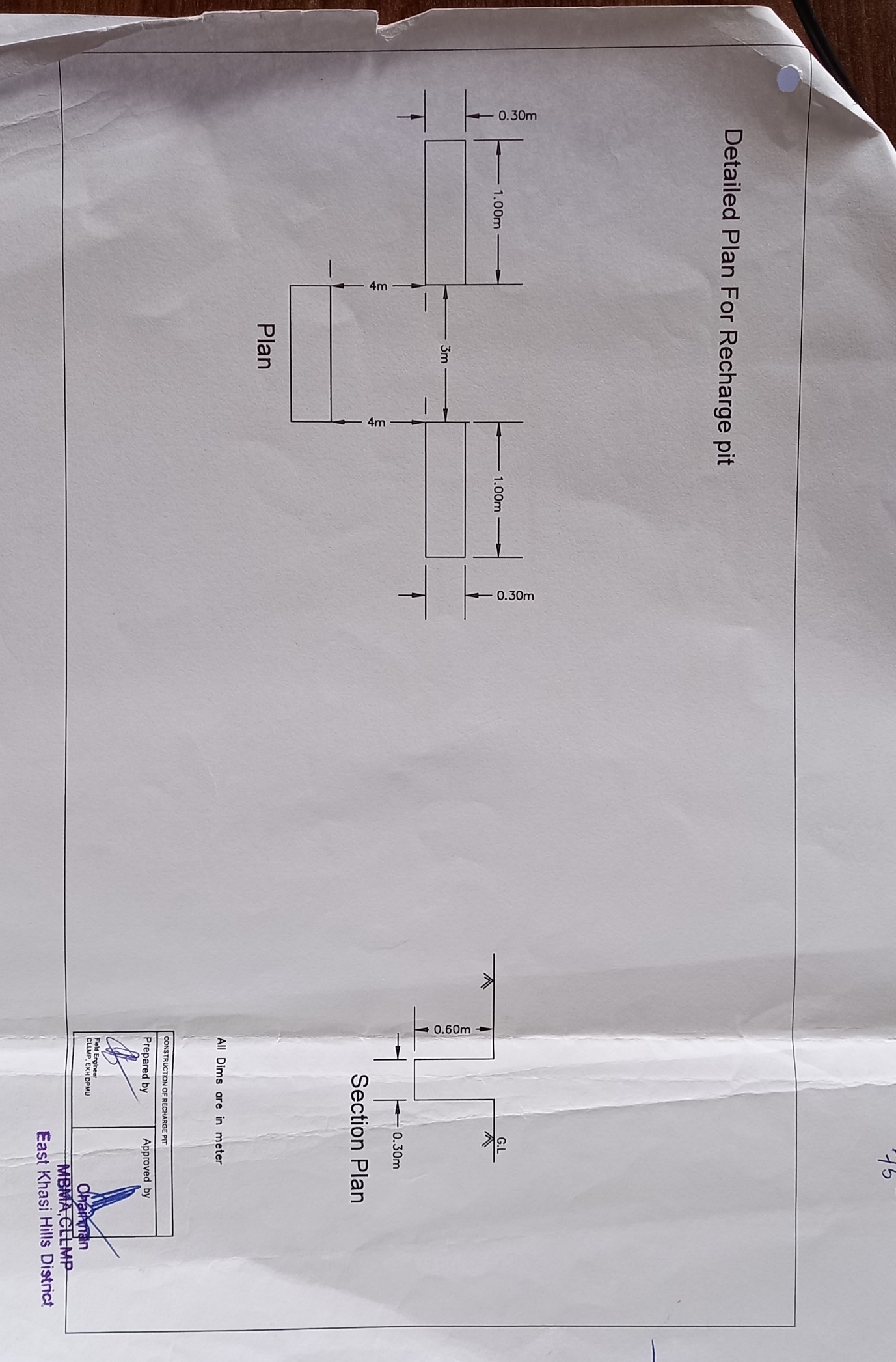
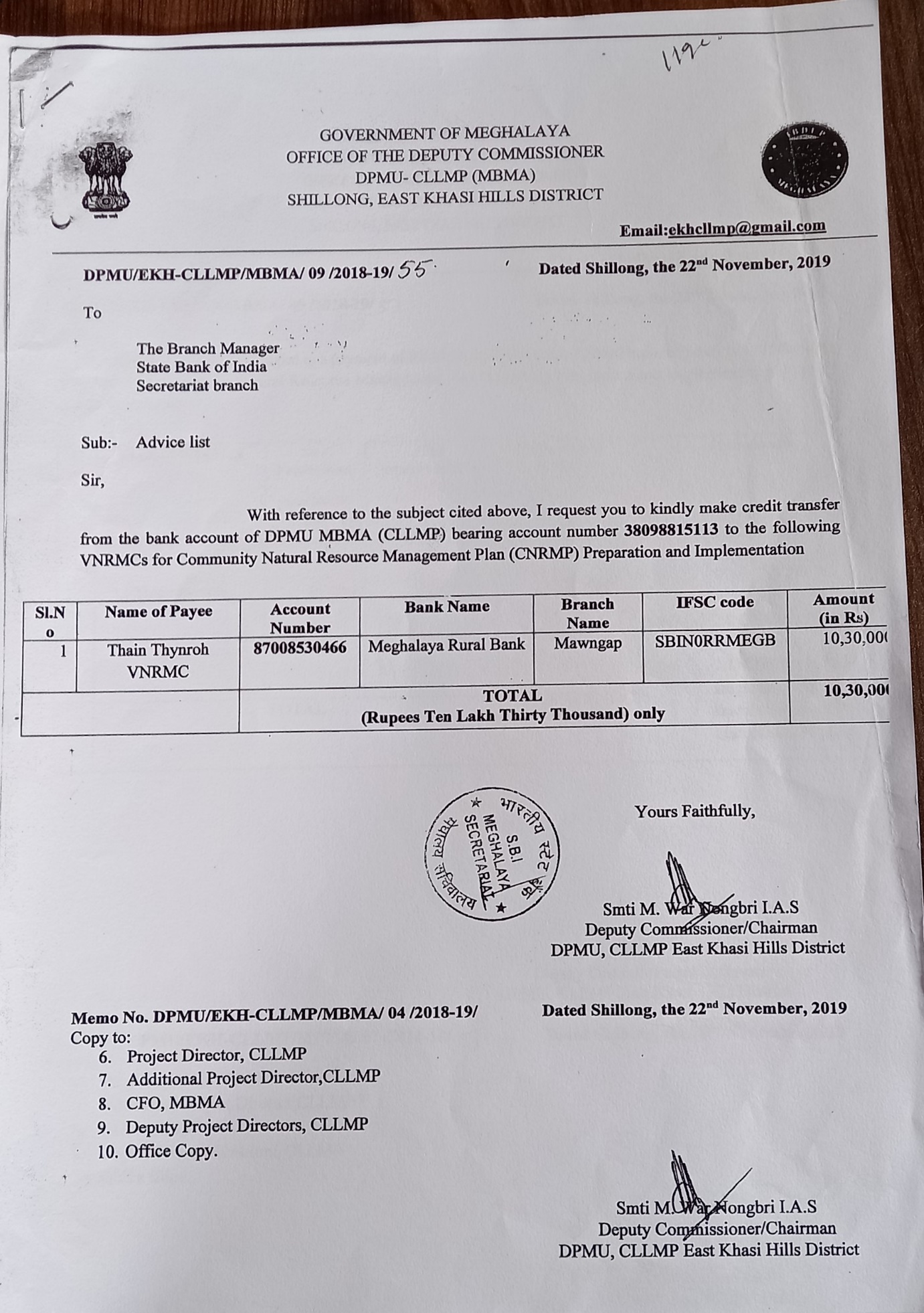
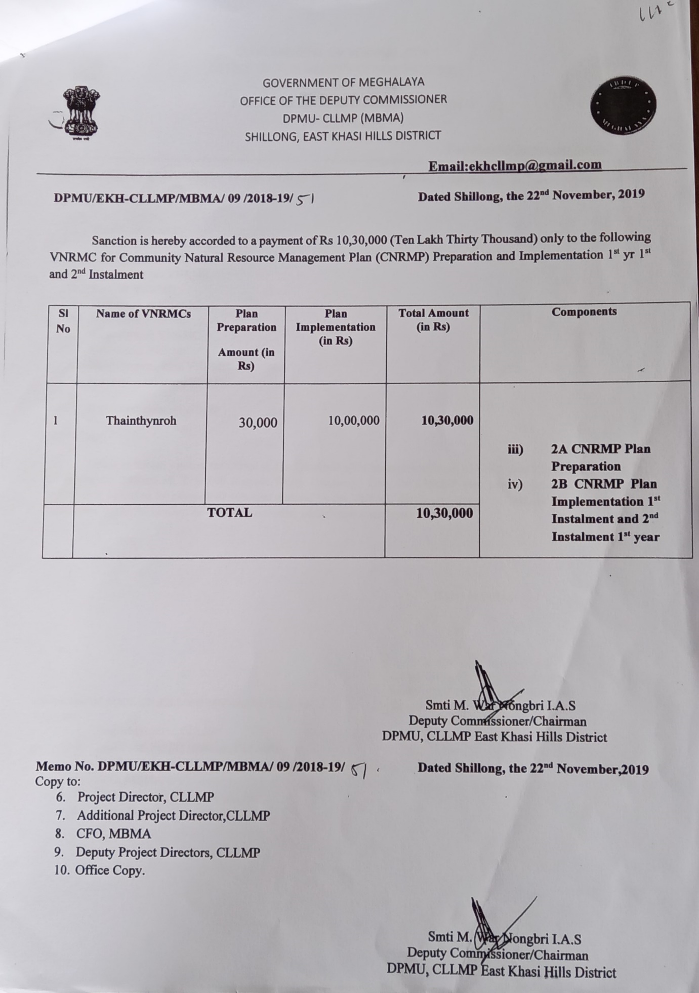
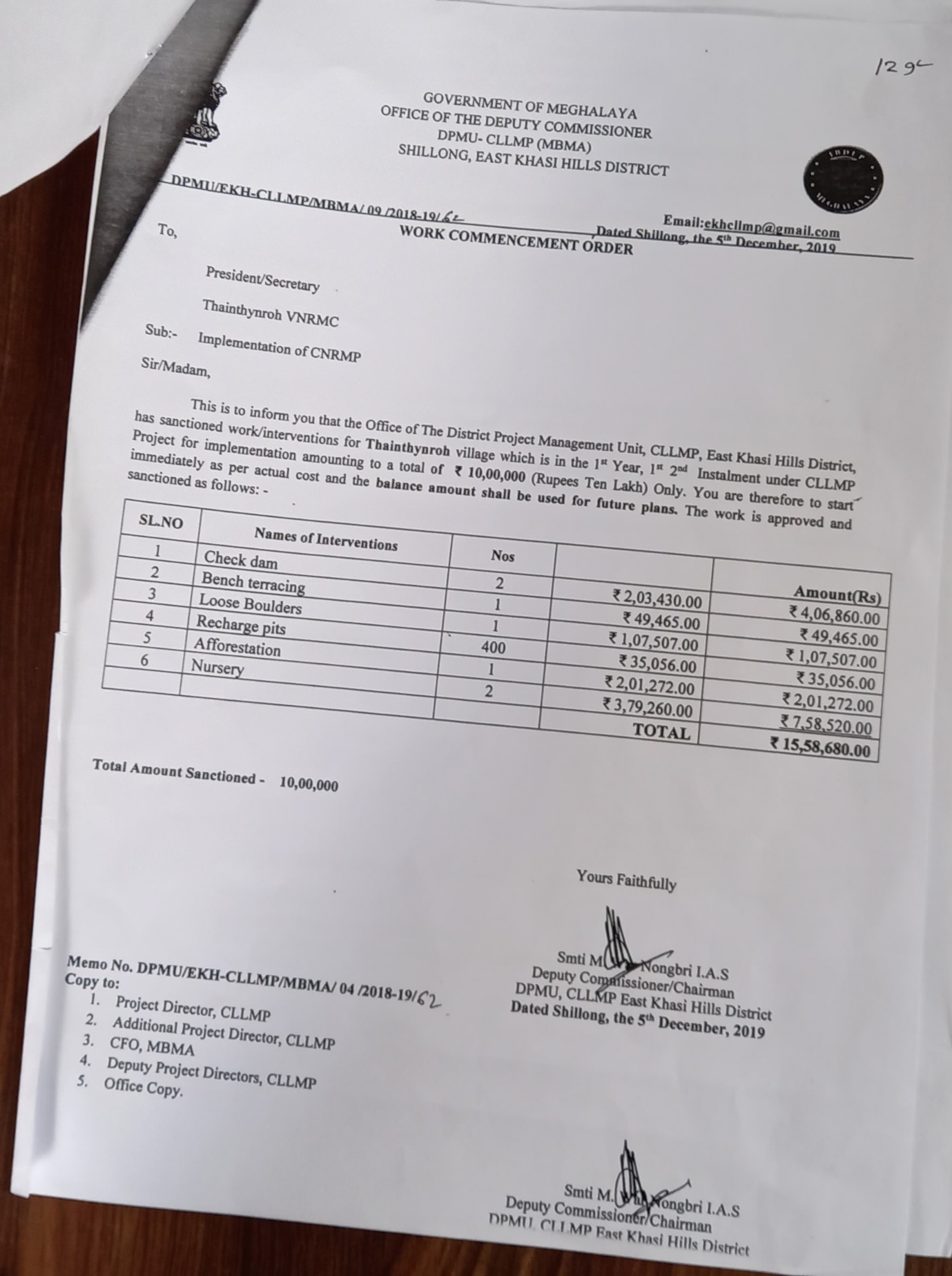
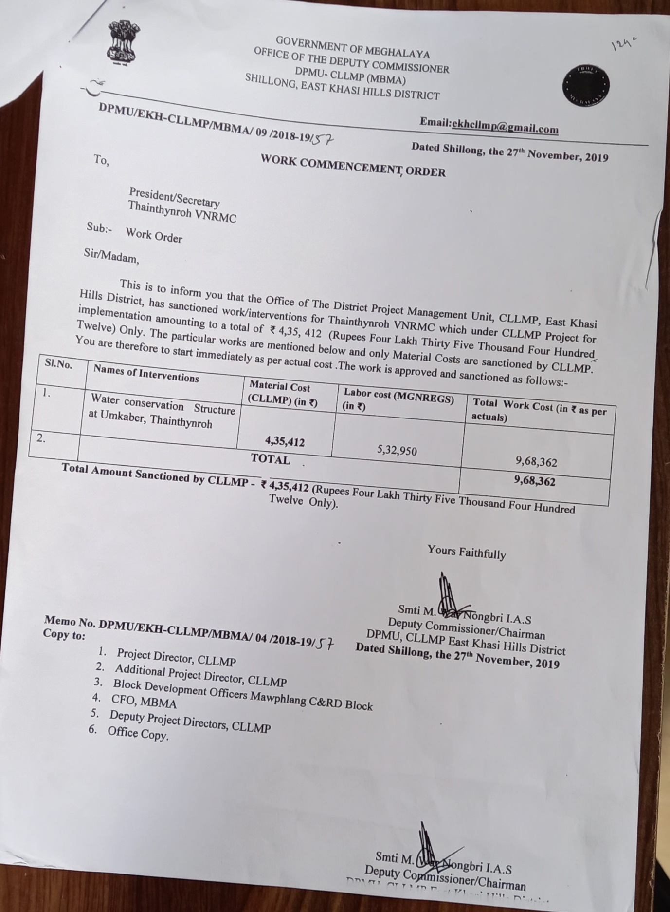
Training on the development of the Community Natural Resource Management Plan (CNRMP) Development of the CNRMP was initiated in Thain Thyrnroh village on the October, 2019. As of this juncture; they laid down two interventions pertaining to water development in the village (Check dam, Recharge pits, Bench trenching, afforestation and Nursery)
A comprehensive one-day training and existing CNRMP review for the VNRMC executive members under all the villages under East Khasi Hills was organised on the October, 2019 by the members of the DPMU. A copy of the environmental templates along with the boundary maps were also circulated to the members and explanation to the templates were made accordingly.
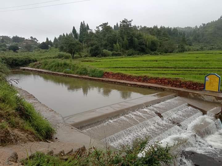
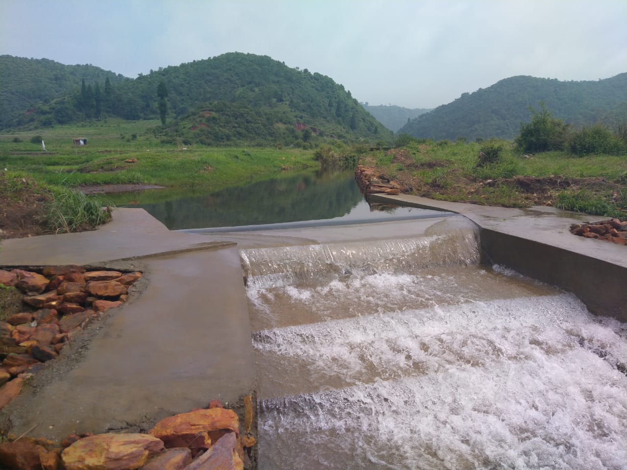
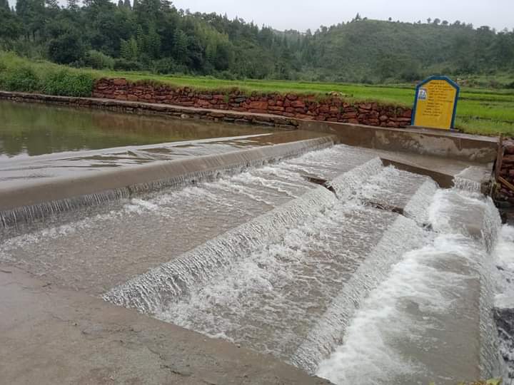
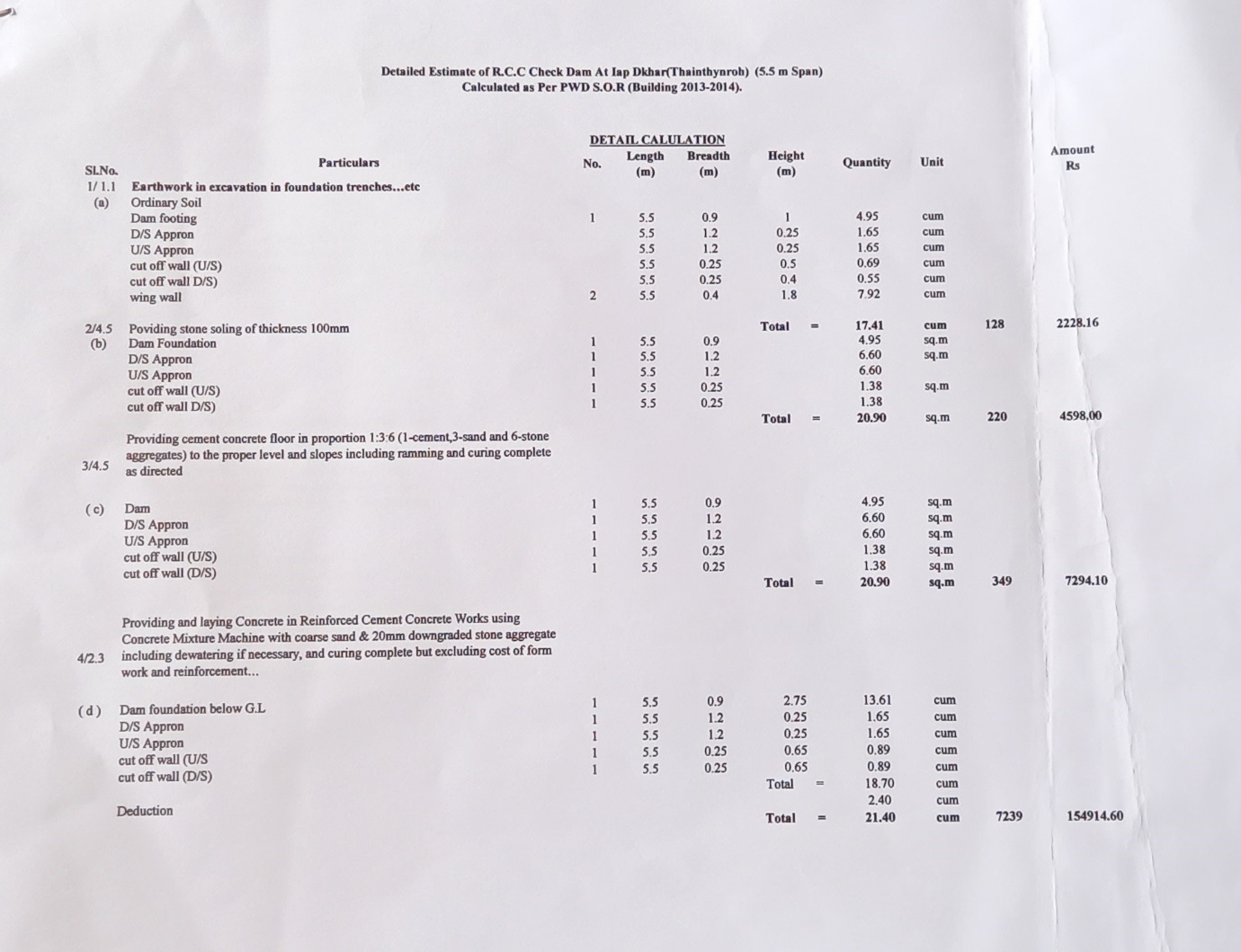
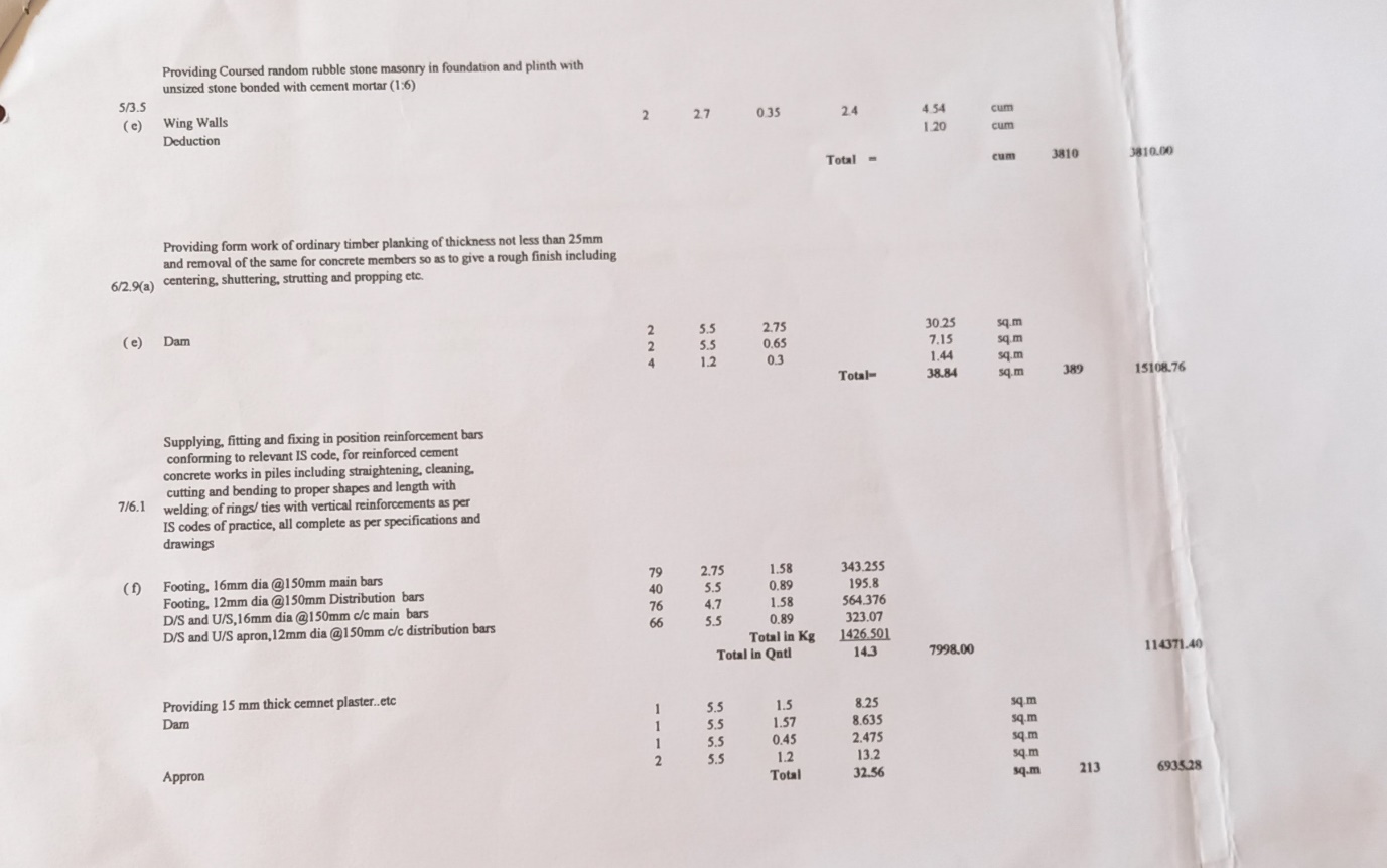
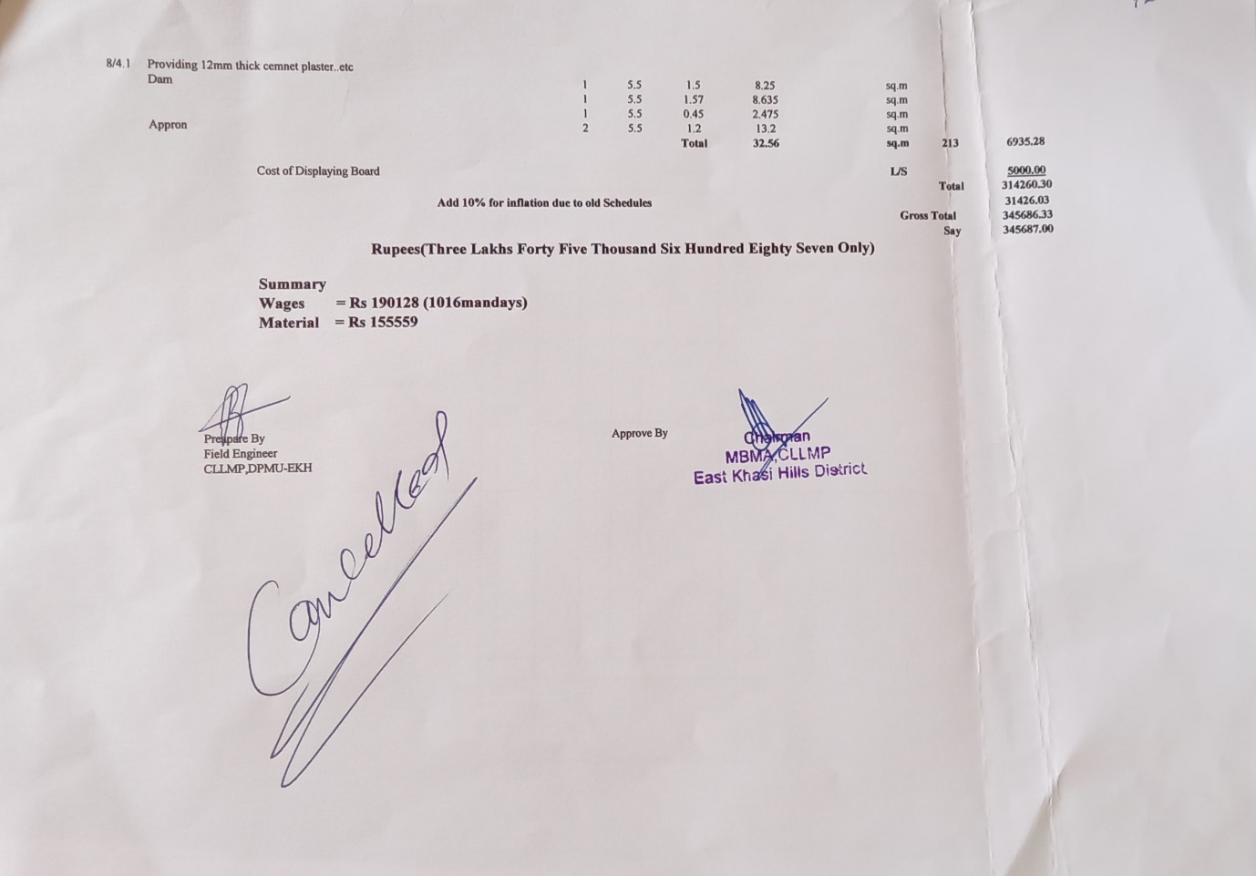
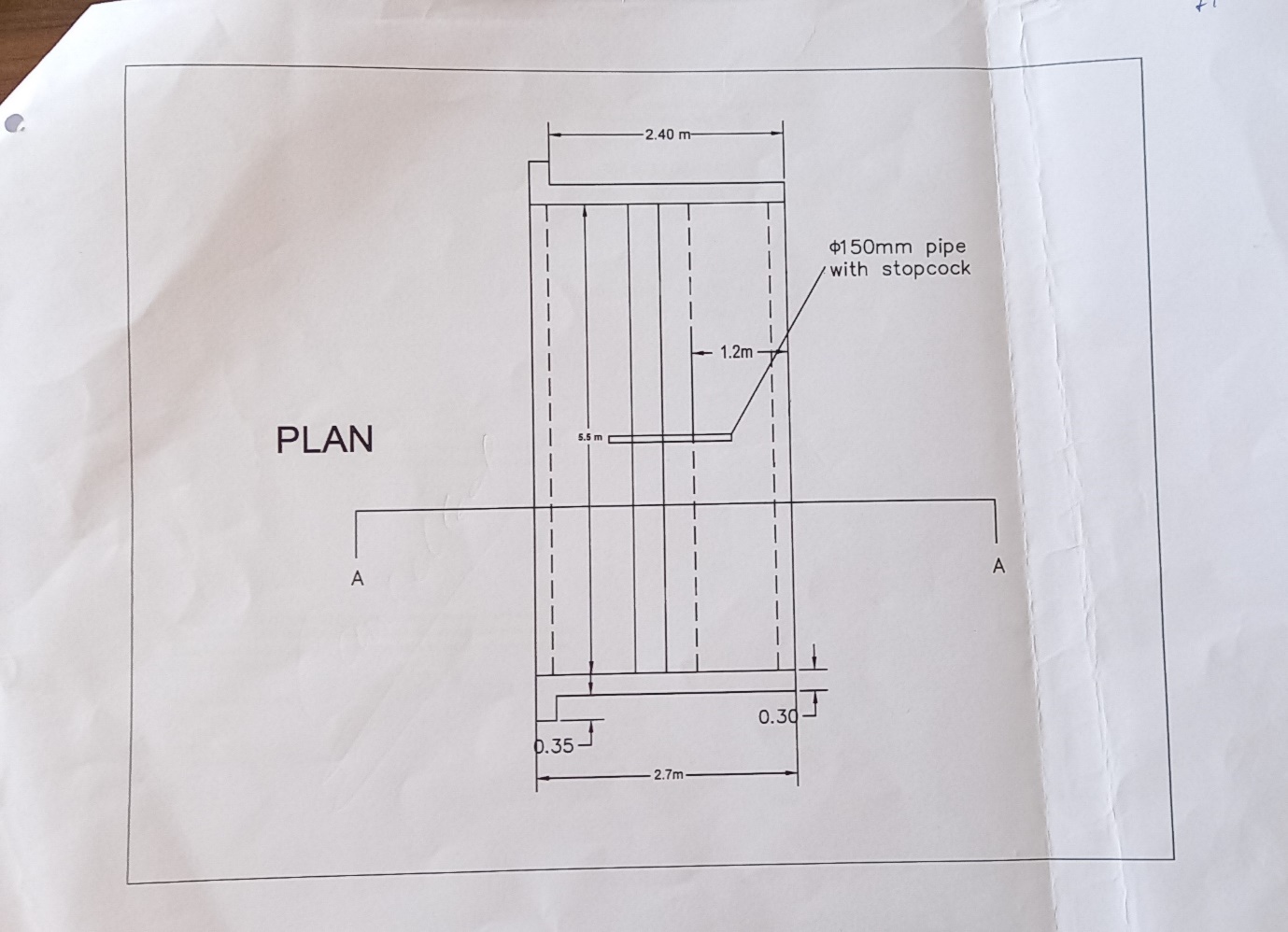
Check Dam at Umkaber, Thain Thynroh
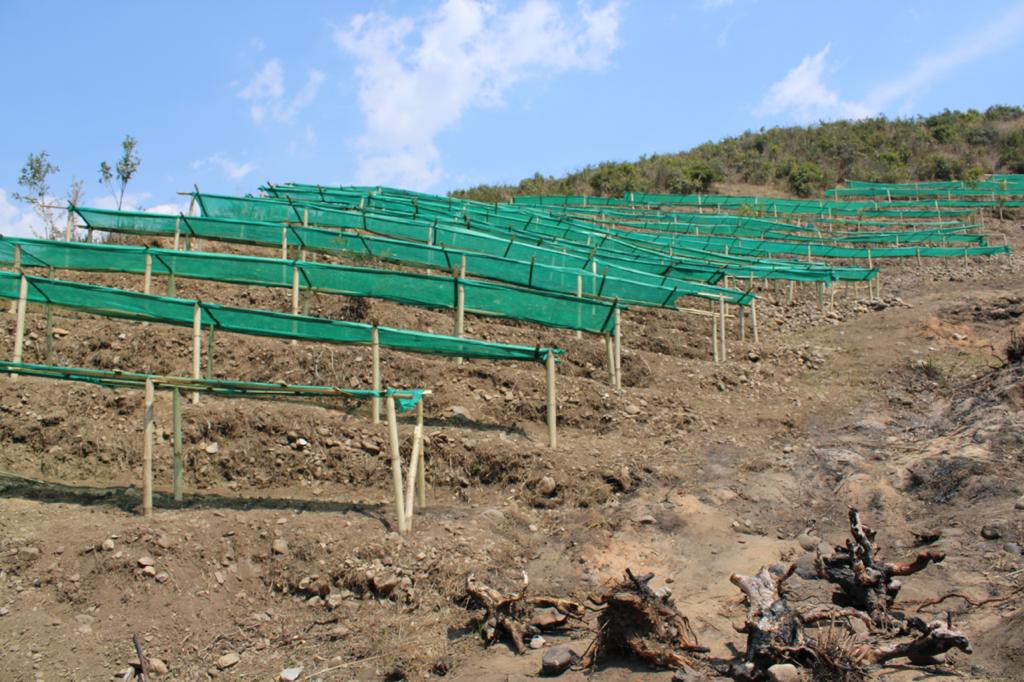
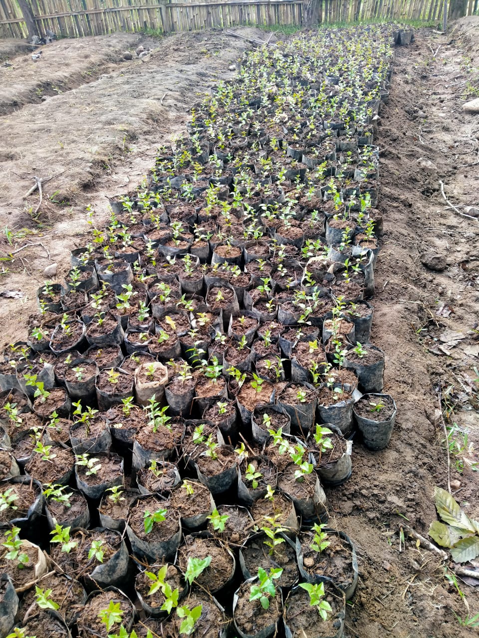
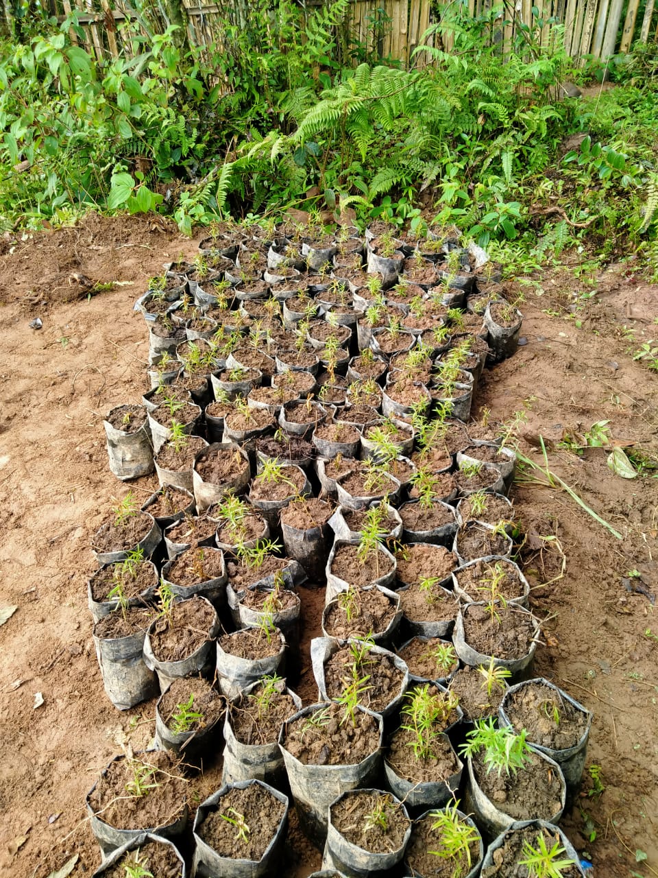 Nursery and Recharge
Pits
Nursery and Recharge
Pits
Community Natural Resource Management Plan Template
VILLAGE SUMMARY
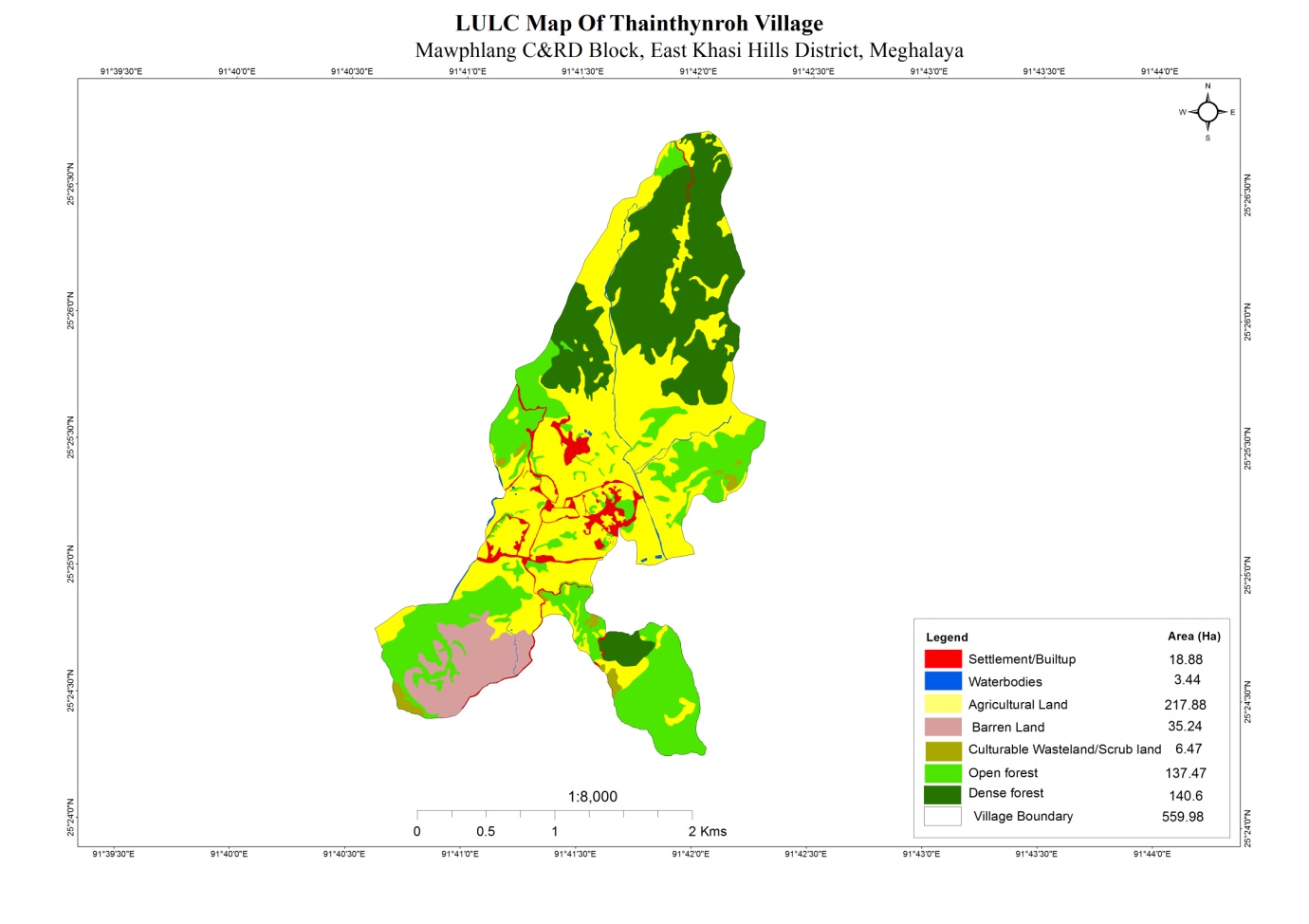
VILLAGE GIS MAP(Baseline Land use land cover map of village to be prepared using information from GIS Atlas and Google Earth as a first step before community mobilisation in the village)
| Sl. No. | Parameters (sl.no.1&2 to be filled by GIS Expert) | Village Information | |||||||||||
|---|---|---|---|---|---|---|---|---|---|---|---|---|---|
| 1 | GPS Coordinates: | ||||||||||||
| i | Latitude | 25.423426 | |||||||||||
| ii | Longitude | 91.69251 | |||||||||||
| iii | Elevation Reading (MSL) | 1686 m | |||||||||||
| 2 | Village Geographical Area (Ha) | Total: 569 Ha 5.69 sq. Km | |||||||||||
| i | Total Forest Area (including community, Clan, Pvt Forest) | 321 Ha | |||||||||||
| ii | Total Area of Water Bodies | 0.42 Ha | |||||||||||
| iii | Total Area under Agri-Horticulture | 127 Ha | |||||||||||
| iv | Total Degraded land area (Ha) | 42 Ha | |||||||||||
| 3 | Average Annual Rainfall (data to be collected from secondary data by DPMU at district/block level and need not be village level) | ……………mm | |||||||||||
| 4 | Soil Type(data to be collected from secondary data by DPMU) | ||||||||||||
|
|||||||||||||
| Sl. No. | Parameters | Village Information | |||||||||||
| 1 | Traditional Land tenure system (Hima /Raid/ /Doloiship/sirdarship/Nokmaakingetc) | Raid Lyngdoh | |||||||||||
| 2 | Distance from Block HQ (Km) | 12 Km | |||||||||||
| 3 | Distance from District HQ(Km) | 40 Km | |||||||||||
| 4 | Community inhabiting the village (Khasi, jaintia, Garo & Others) | Total =1 | |||||||||||
| 5 | No of HHs in the village | 186 | |||||||||||
| 6 | Total population | 1115 | |||||||||||
| 7 | Demographic | M | F | Total | |||||||||
| i | 0-4 | 48 | 53 | 101 | |||||||||
| ii | 5-14 | 96 | 110 | 206 | |||||||||
| iii | 15-30 | 140 | 146 | 286 | |||||||||
| iv | 30-60 | 149 | 169 | 318 | |||||||||
| v | Above 60 | 99 | 105 | 204 | |||||||||
| 8 | Major occupations of people in the village (in order of importance). (Collect only one major occupation per HH. The Number of all occupation should be equal to total no.of HH in the village.) | ||||||||||||
| Occupations | HHs | ||||||||||||
| i | Farmer | 152 | |||||||||||
| ii | Teacher | 7 | |||||||||||
| iii | Govt. Employee | 3 | |||||||||||
| iv | Business | 9 | |||||||||||
| v | Labourer | 15 | |||||||||||
| vi | |||||||||||||
| 9 | Public Transport Facilities to & from village Yes/No:…if yes (specify) |
|
|||||||||||
| Ii. Sumo | |||||||||||||
| Iii | |||||||||||||
| Iv | |||||||||||||
| 10 | Energy fuel use by HHs | No of HH | Qty (Kg/HH) | Total | |||||||||
| i | Charcoal | NA | NA | NA | |||||||||
| ii | Wood | 104 | 1460 | 151840 | |||||||||
| iii | LPG | 72 | 1095 | 10950 | |||||||||
| iv | Kerosene | ||||||||||||
| v | Electricity | ||||||||||||
| 11 | Does the village have sites of Tourist interest | No | |||||||||||
| If Yes mention the site & No of Tourist | No of Tourist per Year | ||||||||||||
| i | NA | ||||||||||||
| ii | |||||||||||||
| iii | |||||||||||||
| 12 | Number of Village Institution with their status | DNA | |||||||||||
| Village Council/ VEC/Traditional Institutions | |||||||||||||
| Water and Sanitation Committee | |||||||||||||
| Self Help Group for Livelihood Activities | |||||||||||||
| Other if any | |||||||||||||
| 13 | Availability of Govt. Water Supply (Y/N) | ||||||||||||
2.1 Traditional Village Institutional Functionaries (Village Dorbar/Nokma/Doloi Council) |
||||||||
|---|---|---|---|---|---|---|---|---|
| Sl No | Name in Full | Gender M/F | Age (in Yrs) | Education | Designation | Occupation | Community | Contact No and email address |
| Banraplang Kharbteng | Male | 33 | IV | Headman | Business | Khasi | 9366942038 | |
| WinsonWell Kharryngki | Male | 32 | VII | Secretary | Farmer | Khasi | 6009657977 | |
| Shonging Kharryngki | Female | 48 | X | Tresurer | Teacher | Khasi | NA | |
| Rim Kharryngki | Male | 60 | I | Member | Labourer | Khasi | 8131829456 | |
| Bakhraw Kharryngki | Male | 65 | VIII | Member | Labourer | Khasi | NA | |
| Kling Kharryngki | Male | 50 | Nil | Member | Labourer | Khasi | NA | |
|
||||||||
|---|---|---|---|---|---|---|---|---|
| Sl No | Name in Full | Gender M/F | Age (in Yrs) | Education | Designation | Occupation | Community | Contact No and email address |
| 1 | Banraplang Kharbteng | Male | 33 | IV | Chairman | Business | Khasi | 9366942038 |
| 2 | Shonging Kharryngngi | Female | 45 | x | Secretary | Teacher | Khasi | NA |
| 3 | Winsonwell Kharryngki | Male | 32 | VII | Treasurer | Farmer | Khasi | 6009657977 |
| 4 | Swod Kharmih | Male | 50 | vi | member | Business | Khasi | NA |
| 5 | Diphen Kharbteng | Male | 52 | vi | member | Farmer | Khasi | NA |
| 6 | Kling Kharryngki | Male | 50 | iv | member | Labourer | Khasi | NA |
| 7 | Amos Swer | Male | 35 | iv | member | Farmer | Khasi | NA |
| 8 | Bakhraw Kharryngki | Male | 65 | viii | member | Labourer | Khasi | NA |
| 9 | Aidaris Kharmih | Female | 25 | x | member | Business | Khasi | NA |
| 10 | Sbianda Kharryngki | Female | 55 | vi | member | AgaNWADI | Khasi | NA |
| 11 | Trai Kharmih | Female | 47 | ii | member | Farmer | Khasi | NA |
| 12 | Aitilang Kharmih | Female | 35 | viii | member | Farmer | Khasi | NA |
| 13 | Maygreen Kharbteng | Female | 43 | viii | member | Farmer | Khasi | NA |
| 14 | Blissfully Sawkmie | Female | 25 | MA | member | Teacher | Khasi | NA |
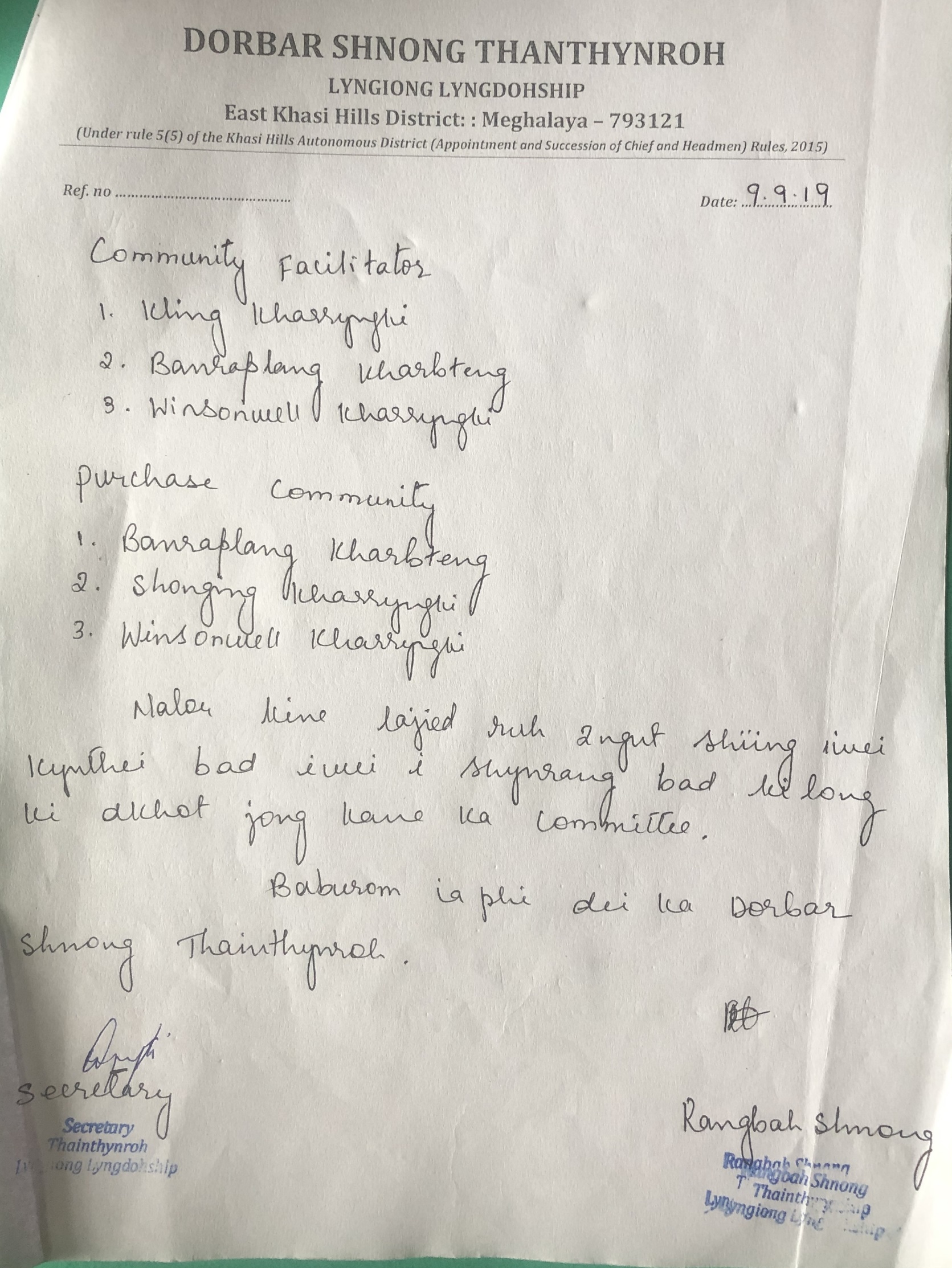
2.3 Green Facilitators
| Sl No | Name in Full | Gender M/F | Age (Yrs) |
Education | Area of specialisation/ focus (forests, water, soil, accounts, environmental and social safeguards, knowledge management, GIS) | Trained under CLLMP (Yes/ No?) if Yes, date training was received | Contact No and email address |
|---|---|---|---|---|---|---|---|
| 1 | Kling Kharryngki | M | 50 | iv | Environment | NO | NA |
| 2 | Banraplang Kharbteng | M | 33 | IV | Monitoring | NO | 9366942038 |
| 3 | Winsonwell Kharryngki | M | 32 | VII | Social | NO | 6009657977 |
| 1 | The exercise should be done in a public place, that all members of the community, can access and participate in; |
|---|---|
| 2 | Facilitators should carry GIS map of village/ Google Earth Map |
| 3 | Introduction on Resource Map to the community; entire community to be present |
| 4 | Facilitate the community to draw the Village Resource Map of the village on the floor/open ground/Chart Paper using participatory tools and locally available materials |
| 5 | Facilitate community to draw village Boundary-basic landmarks such as roads streams, rivers, forests, agricultural land etc |
| 6 | Map out details of land use such as Community forest, clan forest, Pvt individual forest, Jhum area, important cash crop areas, Agriculture areas, Agro forestry, degraded land area, sand/stone quarries, coal mining areas, steep slope areas, low land areas, wasteland & Plant species in each forest type etc. |
| 7 | Map out details of water bodies such as springs &springshed, water catchment areas, ponds, lakes, water reservoirs, sites for fishing etc & Temporary features (Seasonal ponds/Lakes) etc |
| 8 | Briefing and validation of the Resource Map with the community. Copy the Resource Map on the paper for official record. Use Standard legends for uniformity and convenience. |
| 9 | Ensure that participants engaged in drawing Resource maps including VNRM committee sign and date at the back of the Resource Map and it is endorsed by the head of the village council |
| 10 | It is recommended that the group prepare two copies of Resource Maps, so that one copy may be given to the community for their future reference. Take a photo |
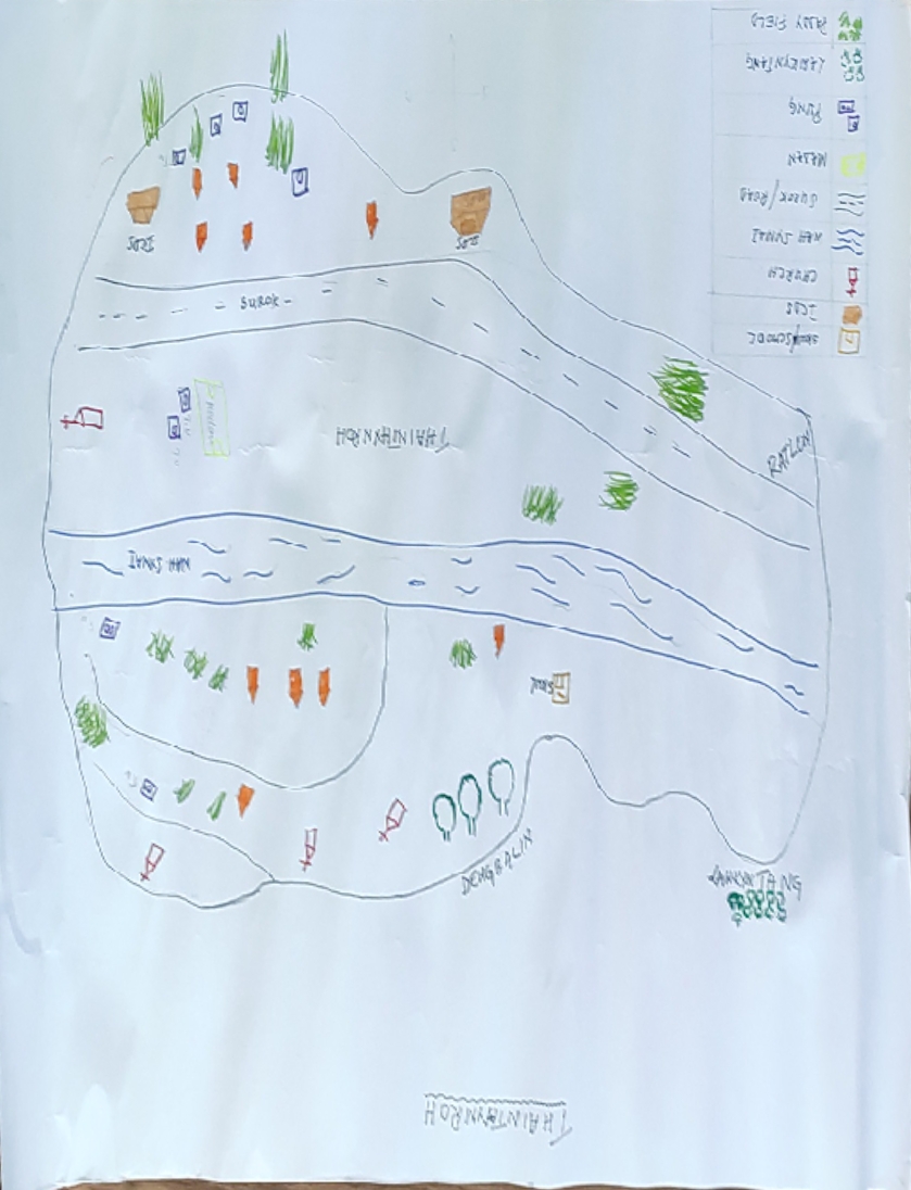
RESOURCE MAPPING
(This is the tool to begin interaction with the people in the village. This exercise will provide an opportunity to bring people together to understand the natural resources of the village towards plan preparation. The facilitators must have the secondary information in advance to be able to facilitate effectively; The information collected through this process should be filled into the template provided for Land Use Pattern.)
LAND USE PATTERN
| Sl No | Land use Category | Land Ownership (Community/Clan /Pvt individual etc) |
Name of the Site |
Quality of forest(Dense, Moderate, open) refer to GIS Map | Land Area /stretch as in the vilage (Ha/Km) |
Present Uses/Benefits HHs=1; Timber =2; NTFP =3; Fuelwood = 4; Medicine & Aromatic plants=5, Others=6 |
Land Area available for intervention (Ha) | Grazing (Y/N) |
Remarks |
|---|---|---|---|---|---|---|---|---|---|
| 4.1 | Forest (Specify type)(total area of all forest should match with forest area of the village measured under GIS) | ||||||||
| Community Forest (Lawshnong/SongniBirungbolgrik) | Community | 1. lumkyntung 2. pom rabin 3. Kyndong iapdkhar 4. Lum thainthynroh 5. lum diengwah 6. lum laitjitu |
Open | 196 | 2, 4, 5 | 27 | Y | Bench Trench, Afforestation and fire line control | |
| Private (Rikynti/) | NA | NA | NA | NA | NA | NA | NA | No Private forest | |
| Clan Forest (Lawkur/Maharini/ Raid | NA | NA | NA | NA | NA | NA | NA | No Clan forest | |
| Protected Forests/ Green Blocks (including Law Adong and Law shnong, forests protected for aesthetic reasons) | Community | Law heh | Dense | 126 | 0 | N | Sacred Groves | ||
| Catchment Areas (water supply) (Area to be filled by GIS) | Community | NA | Open/Agricultrural land | 190 | 30 | Y | Bench Trench, Afforestation and fire line control |
| SL. No. | Land use Category | Land Ownership (Community/Pvt individual etc) |
Name of the Site |
Land Area available for intervention (Ha) | Source of Seeds Community Nursery=1 Purchase=2 Others=3 |
Use of Organic Fertiliser/Bio-Pesticide/Bio-Insecticides etc. (Y/N) |
Remarks | ||||||||||||||||
|---|---|---|---|---|---|---|---|---|---|---|---|---|---|---|---|---|---|---|---|---|---|---|---|
| 4.2 | Cultivable Land (Area in ha to be filled by GIS) | (To be filled by DPMU team) | (To be filled by DPMU team) | ||||||||||||||||||||
| 1 | Area under Agriculture (Mention Ha under each crop – Paddy (37 Ha), Maize (10 Ha) vegetable (50)) wet land (Paddy Field) | Community | NA | 0 | 2, 3 | Y | |||||||||||||||||
| 2 | Area under Horticulture (Mention Ha under each type) |
NA | NA | NA | NA | NA | No horticulture | ||||||||||||||||
| 3 | Area under Cash Crops 1 (Specify) Potato = 20 Ha | Community/Private | NA | 0 | 2, 3 | Y | |||||||||||||||||
| 4 | Area under Cash Crops 2 (Specify Tomato= 10 ha) | 0 | 2, 3 | Y | |||||||||||||||||||
| 5 | Area under Shifting Cultivation Average cycle (5 yrs) | Community | NA | 0 | 2, 3 | Y | 9 Ha area under Jhum Cultivation | ||||||||||||||||
| 6 | Culturable Wasteland(to be filled by GIS ) | Community | NA | 15 | NA | NA | |||||||||||||||||
| SL. No. | Land use Category | Ownership/Community/Private | Name of the water body/spring |
GPS coordinates (to be filled by technical team) | No of Dependent HH (to be filled by social survey team) | Nature of water body (Perennial/Seasonal) (to be filled by technical team) | Existing Soil & Water Conservation structures (to be filled by technical team) |
Water quality tested (Y/N) (to be filled by technical team) |
Size/length of River /stream (Ha/Km) (length of river, stream, to be provided by GIS) |
Present use/Benefit (fisheries/irrigation/drinking water) (to be filled by social survey team) |
Number/Area available for intervention (to be filled by technical team) |
Remarks (to be filled by DPMU) | |||||||||||
| 4.3 | Water Bodies (specify) | ||||||||||||||||||||||
| 1 | Springs/Water Source | Community | 1. Madan limpluh 2. mynrang 3. dong lum 4. shingiar 5. umlingpung 6. crochar 7. mawkynjuh khla 8. mawshut 9. lumlingding |
DNA | DNA | DNA | DNA | N | NA | drinking & domestic | 0 | No Springshed development interventions selected byt he community | |||||||||||
| 2 | Natural ponds | NA | NA | NA | NA | NA | NA | NA | NA | NA | NA | No Natural Ponds | |||||||||||
| 3 | Lakes | NA | NA | NA | NA | NA | NA | NA | NA | NA | NA | No Natural Lake | |||||||||||
| 4 | Streams within village area |
Community |
1. Sdad 2. wah traimulieh 3. pungklong 4. umdieiang |
1. 25.422620 91.695876 2. 25.424658 91.697898 3. 25.414330 91.686794 4. 25.411092 91.687277 |
NA | Perenial | Check Dam | N | 1. 2.71 km 2. 0.8 km 3. 0.46 km 4 0.27 km |
Domestic & irrigation | 1 | Check Dam at various location of Sdad Stream | |||||||||||
| 5 | Rivers within Village Geographical area | Community | wah kyndongmeria | 25.423561 91.685538 |
NA | Perenial | Washing Platform | N | 2.36 km | Domestic & irrigation | 1 | Check Dam has been proposed as intervention | |||||||||||
| 6 | Others (Specify) | ||||||||||||||||||||||
| 4.4 | Indigenous/ Cultivated Trees and NTFPs in Forests | List of Species | Main use (Household/ Commercial) |
|---|---|---|---|
| 1 | Indigenous Tree species in Forest | Dieng wah, sai, sohot, shit, stap, linglaw, sohphoh | Timber & Fuelwood |
| 2 | NTFPs in Forest including medicinal shrubs/trees etc | kymbat jakoid, dieng khong, sohkrot | Traiditional Healer |
| 3 | Commercially valued Trees/ Shrubs/Plants in forests/ | ||
| 4 | Fodder Species/ Valuable grasses in forests | ||
| 5 | Any vulnerable/ endangered species in Forest (fauna & flora) ) | ||
| 6 | Invasive plant Species (if any) |
5. PROBLEM ANALYSIS
(These are some questions to facilitate FGDs to get an understanding on the challenges and concerns in the village. Some of the issues could be Soil degradation/erosion; Forest Fires; Unscientific Mining; Deforestation; Degraded Jhum Lands; Waste/Pollution; Mining runoff; Siltation; Over- extraction. This information will help fill the form 5.1, 5.2, 5.3 and 5.4. The information can be collected in advance or substantiated later with the help of secondary sources. The interaction should take place as a discussion and the forms should be filled after the discussion, and not during it)
Do people have sufficient access to supply of fodder, fuel wood, leaf litter?
Yes
Has access to timber improved or reduced over the years? How is access for household use and commercial use managed?
Reduced
Are the water bodies facing any threats?
Yes
Do all people in the village have access to drinking water? What are the challenges?
Yes. Mostly depends on PHE water and some springs are seasonal
Are there degraded areas in the village (open/ degraded forests, mining affected, high soil erosion etc.)?
Yes. Open forest at some part of the village also stone/sand quarrying, soil erosion along the river bank
What has caused this degradation? Are there practices causing threats to availability and access to natural resources?
Jhum is the cause for open forest, mining are for the livelihood. Yes practices are threats to the natural resources
What have been the changes in agricultural practices?
Are there any challenges in farming?
Farming is based on rainfed
How would you consider the health situation in your village?
Good
How is the situation of cleanliness, sanitation, access to toilets and waste management?
Good
Who are the most vulnerable in the village? What can be done to improve their lives?
Farmers, old aged
What are the livelihood aspirations of the youth? Are there any avenues available?
Business, quality farming, Job
Do any committees/ institutions/ rules exist to manage and monitor natural resources in the village?
Yes, but only related to forest timber
What are some of the major issues of conflict in the village?
No major issues
Have any of the above issues been discussed in village meetings?
How do people resolve disagreements and conflicts?
| 5.1 | Land | ||||||||
|---|---|---|---|---|---|---|---|---|---|
| Sl No | Category of Land/Water Body |
Soil degradation/erosion (in Ha) (DPMU to collect from secondary data) |
Forest Fires (in Ha) | Un scientific Mining (in Ha) |
Deforestation (in Ha) (To be filled by GIS) |
Degraded Jhum Lands (in Ha) | Others (in Ha) | Total Area Affected (approx. in Ha) |
Remarks |
| 1 | Land | ||||||||
| A | Forest | 0 | 27 | 0 | 0 | 6 | 0 | 33 | |
| B | Cultivable land | 12 | 0 | 0 | 0 | 0 | 0 | 12 | |
| C | Others (Specify) | ||||||||
| 5.2 | Water Bodies Affected | |||||||||
|---|---|---|---|---|---|---|---|---|---|---|
| Sl No | Category of Land/Water Body | Number affected & Name of sites | Waste/ Pollution | Mining runoff | Siltation of water bodies | Over- extraction | Deforestation in Catchment | Test Result? (attach) | Others (Specify)
|
|
| Solid Waste | Domestic waste water | |||||||||
| 2 | Water Bodies | |||||||||
| A | Springs (name of springs) | 1 | ||||||||
| 2 | ||||||||||
| 3 | ||||||||||
| 4 | ||||||||||
| 5 | ||||||||||
| 6 | ||||||||||
| B | Stream (number) | 1. Sdad 2. Traimulieh |
0 | 0 | 0 | Yes | 0 | 0 | N | |
| C | River/ pond/ lake | |||||||||
| 5.3 | Disputes / Constraints encountered by Community | |||||
|---|---|---|---|---|---|---|
| Sl No | Type of Resource | Dispute (mention if within village=1 or with other village/s =2) | Constraint | Rating/Frequency/ Number of Months in the year | Proposed resolution | Priority (can be addressed through CNRM plan) |
| 1 | Village Geographical Boundary | No | No | NA | NA | NA |
| 2 | Drinking Water | No | No | NA | NA | NA |
| 3 | Water for irrigation | No | No | NA | NA | NA |
| 4 | Access to land for construction of House | No | No | NA | NA | NA |
| 5 | Access of land for cultivation | No | No | NA | NA | NA |
| 6 | Access to timber for construction etc | No | No | NA | NA | NA |
| 7 | Access to NTFP (Wild vegetables, canes and bamboo, lac, Herbal medicines etc) | No | No | NA | NA | NA |
| 8 | Access to Fodder | No | No | NA | NA | NA |
| 9 | Access to Fuel wood | No | No | NA | NA | NA |
| 10 | Access to LPG | No | No | NA | NA | NA |
| 11 | Access to solar cookers/ heaters | No | No | NA | NA | NA |
| 12 | Access to Food/PDS | No | No | NA | NA | NA |
| 13 | Others (Specify) | No | No | NA | NA | NA |
| 5.4 | ||||||
|---|---|---|---|---|---|---|
| Sl No | Environment Parameters | Rules & Management System In Place in Village Yes =1; No = 2; Not Applicable (NA)=3 |
Management Committee/Volunteers in place (Y/N and Composition) |
Contact Person and contact Details | ||
| Y/N | No of M | No of F | ||||
| 1 | Access for timber/NTFPs etc from community forest | 1 | Y | 4 | 3 | Synjuk Arliang Wah |
| 2 | Access for cultivable land for villagers from community land | 2 | N | NA | NA | NA |
| 3 | Protection of spring sheds, water sources | 2 | N | NA | NA | NA |
| 4 | Protection of catchment areas | 2 | N | NA | NA | NA |
| 5 | Prevention of forest fires | 2 | N | NA | NA | NA |
| 6 | Conservation of aquatic life in rivers, streams etc | 2 | N | NA | NA | NA |
| 7 | System for Disposal of solid waste | 2 | N | NA | NA | NA |
| 8 | System for treatment of Household affluent | 2 | N | NA | NA | NA |
| 9 | Cleanliness of village - roads, footpaths | 2 | N | NA | NA | NA |
| 10 | Social fencing for Protection of stray cattle/other domestic animals | 2 | N | NA | NA | NA |
| 11 | Participation of women in decision making at various platforms | 2 | N | NA | NA | NA |
| 12 | Rate of wages for both men and women for different types of labour | 2 | N | NA | NA | NA |
| 13 | Ensuring survival of young plantations (upto 5 years) | 2 | N | NA | NA | NA |
| 14 | Management of afforested plots | 2 | N | NA | NA | NA |
| 15 | Eco-Tourism | 2 | N | NA | NA | NA |
| 16 | Others (Specify) | 2 | N | NA | NA | NA |
6. CNRM PLAN PREPARATION
The idea is to create a positive environment where the people discuss problems but with a target of solving them, moving to a higher goal, identifying that goal and a collective vision.
There are many ways of facilitating a visioning exercise. If the group is very large then they can be broken into smaller groups, if the group is small, then questions can be posed for each individual. Based on small group discussions or individual map a depiction of what the village would be ten years from now can be prepared. Facilitators should aim to break the ice and help the group think about their vision. Make the exercise fun by asking “if you had a magic wand what would you change” or “if you had one wish what would you do for your village”. There is no harm in starting from personal aspiration- ask parents what they want for their children or ask youth what their aspirations are.
Each small group or individual can be given a topic/area: forests, agriculture, water, school, health, transport, livelihood, tourism and so on. They can be asked to discuss the problem today that needs to be solved and what they see in this area ten years from now. Based on the discussion or reflection, a combined chart can be prepared the issues can be written and another chart where the vision/desire/wish/goal can be written for each area. This process helps people to think holistically and not see the project as a source of a few activities.
This vision chart can be a basis to start the next set of discussion, on prioritization of interventions and be a reference document to help plan under the project.
6.2 Prioritization Exercise
The exercise should build on the resource map and baseline information collected to arrive at potential interventions and initiatives the community would like to plan to achieve their vision for improvements in the state of natural resources of their village.
Group Discussion - Groups of different age groups such as youth men, youth women, men above 30, women above 30 years old.
Facilitate each group to discuss the pressures and challenges related to natural resources in the village, existing best practices and knowledge within the village and then envision improvements that could enhance the state of natural resources and contribute to an improved resource base.
Facilitate them to prioritize new interventions and initiatives to achieve these improvements. Map out the proposed interventions and initiatives using the resource map and write up the interventions in a tabular format
Copy the Vision map on paper for purpose of record and attach the group discussion points of different groups. The list of participants of each group may be attached for future reference.
Geo-tag intervention sites, take photos of sites during the planning stage to compare through the cycle of intervention.
| 6.3 Intervention identification | ||||||||
|---|---|---|---|---|---|---|---|---|
Area of Intervention |
Soil & Water Conservation |
Land Productivity Enhancement |
Spring Shed Management |
Afforestation/ Community Forestry Activity |
Capacity Building |
Others |
Remark on any traditional knowledge/ best practice within the village |
|
Intervention 1 |
Activity/ Site |
Check Dam, Afforestaion & Loose Boulder Bund/ Iap Dkhar |
||||||
Intervention 2 |
Activity/ Site |
Check Dam, Afforestaion & Loose Boulder Bund/ Raimulong |
||||||
Intervention 3 |
Activity/ Site |
Bench Terraing for Agri- Horti, Staggerred Trnches & Afforestation/ Raimulong |
||||||
Intervention 4 |
Activity/ Site |
Check Dam & loose Boulder Bund/ Mawhing |
||||||
Intervention 5 |
Activity/ Site |
Check Dam/ Kyndon Wahlyer |
||||||
Intervention 6 |
Activity/ Site |
Community Nursery/ Umling Pung |
||||||
Intervention 7 |
Activity/ Site |
Gully Plug, Recharge Pits/ Stagerred Treches, Afforestation & Community Nursery/ Umling Pung |
||||||
Intervention 8 |
Activity/ Site |
Check Dam / Umlangpung |
||||||
Intervention 9 |
Activity/ Site |
Bench Terracing for Agri- Horti/ Raimulong |
||||||
*Note: Consider following criteria for prioritizing the water sources for intervention:
a) Number of dependent households b) Discharge level c) Demand vs Supply Gap d) Drastic change in discharge e) Availability of Land for intervention f) Willingness of communities/individuals
For prioritized springs, fill and attach Annexure-B (Spring Information Form)
|
Name of Proposed Interventions | Site |
|
Nos of HHs expected to Benefit | Priority (High/ Medium/ Low) | Start date (MM/YY) | Completion date (MM/YY) | ||
|---|---|---|---|---|---|---|---|---|---|
|
|
|
|||||||
| Check Dam, Afforestaion & Loose Boulder Bund | Iap Dkhar | Community | 50 | 50 | High | ||||
| Check Dam, Afforestaion & Loose Boulder Bund | Raimulong | Community | 50 | 50 | High | ||||
|
Raimulong | Community | 50 | 50 | Medium | ||||
| Check Dam & loose Boulder Bund | Mawhing | Community | 50 | 50 | High | ||||
|
Kyndon Wahlyer | Community | 70 | 10 | 80 | High | |||
|
Umling Pung | Community | 170 | 10 | 180 | Medium | |||
|
Umlangpung | Community | 40 | 40 | High | ||||
|
Raimulong | Community | 70 | 70 | Medium | ||||
6.5 Training and Capacity Building for implementing CNRM Plan
Sl
|
Type of Training/ Cap Building Activity | No of People | Target audience (VCF/VNRMC) | Proposed frequency | Remarks | ||
|---|---|---|---|---|---|---|---|
| 1 | Training on Solid Waste Management | ||||||
| 2 | Training on Gender inclusion | ||||||
| 3 | Training on Landscape Management | ||||||
| 4 | Social Management and Community Mobilization | ||||||
| 5 | Soil and Water Conservation | ||||||
| 6 | Land Productivity Enhancement | ||||||
| 7 | Forestry and Agroforestry | ||||||
| 8 | Community Nursery and Nursery Management | ||||||
| 9 | Spring Shed Management and Development | ||||||
| 10 | Other training required (please specify) | ||||||
6.6ENVIRONMENT ELIGIBILITY SCREENING
| Sl. No | Activities/Subprojects with any of the attributes listed below will be ineligible for support under the proposed project due to environmental implications. | Yes/No |
|---|---|---|
| 1 | Any subproject/activities that is not consistent with Acts of GoI and GoM | No |
| 2 | Subproject/activities that could intervene or damage/fragment and/or adversely affect/ impact natural habitats/ protected areas, reserve forests, including but not limited to, the following sites:
|
No |
| 3 | Subproject/activities that support forest harvesting on a large/industrial scale | No |
| 4 | Activity that involves construction of check dam >3m height | No |
| 5 | Subprojects/activities that promote or require pesticides that falls in WHO classes IA, IB, or II and/or procurement of large amount of pesticides or toxic agro-chemicals. | No |
| 6 | Subprojects/activities will not support large- scale clearing of land, dredging of water bodies, undercutting of slopes, replacement of natural vegetation that may cause permanent, irreversible impacts. | No |
| 7 | Any activity that has a significant potential of causing forest fires | No |
| 8 | Any project activity that leads to large-scale soil erosion and siltation of water bodies | No |
| 9 | Any activity that promotes or involves incidence of child labour. | No |
| 10 | Sub project/Activities that would adversely affect cultural sites, places of significance importance and protected historical assets (both living and built) | No |
| 11 | Sub project/Activities that involves the felling of the ‘prohibited trees’ without a permit | No |
| 12 | Sub project/Activities that seeks to impose restrictions or loss of access to using natural resources, including medicinal plants or those of economic value for livelihoods. | No |
| 13 | Any activities involving use of Asbestos Containing Materials (e.g. Pipes for community irrigation schemes). | No |
If Yes- reject /modify activities in the plan to meet the criteria.
6.7 ENVIRONMENTAL REGULATORY COMPLIANCE SCREENING
| S. No. | Regulatory requirements | Implications for project | |
|---|---|---|---|
| I | Are any of the activities located within a notified Eco Sensitive Zone (ESZ)?
If yes, Are any of the activities on the list of activities regulated in ESZ? If yes, Has the required permission been taken? |
NO No No |
|
II III |
Are any of the activities involving construction located between 100-300 meters from an archaeological site/monument. If yes, has permission been taken from the Archaeological Survey of India? |
No No |
Follow EGs on Chance find procedures |
IV V |
Do any of the activities require license under the Fertilizer Order 1985 (selling, stocking, exhibiting for sale or distribution of bio-fertilizers and organic fertilizers)? If yes, has the license been taken? |
No No |
Follow General Rules under Fertilizer Order 19851 |
6.8 Social Screening Checklist
LAND MANAGEMENT2
| Screening Questions | Yes | No | Details/Remarks | |
|---|---|---|---|---|
| 1. | Is there land requirement under each proposed intervention? | Yes | What is the size of land required per intervention? Who owns the land (Community, Clan or Private) |
|
| 2. | Does the land selected ensure minimum adverse impact? | |||
| 3. | Is there any impact on: | Provide number of affected persons per intervention | ||
| Agricultural land | Yes | |||
| Forest land | Yes | |||
| Access to common resource (mention type of resource) | Yes | |||
| 4. | Are the estimated affected persons from the vulnerable category? | No | Provide number of affected persons per intervention | |
| Women headed HH | ||||
| BPL HH | ||||
| 5. | Will land be taken on voluntary land donation? | No | ||
| 6. | Have the principles and procedures3 for voluntary land donation been duly followed? | |||
| 7. | Have due precautions been taken to minimize disturbance to sensitive locations or locations having cultural significance? | Yes |
SOCIAL INCLUSION4
| Screening Questions | Yes | No | Details/Remarks | |
|---|---|---|---|---|
| 1. | Was separate consultation held with different groups? | No | Mention type of interaction and location | |
| Women | ||||
| Youth | ||||
| Low income families | ||||
| Minority groups | ||||
| Any other | ||||
| 2. | Are the concerns and priorities of different groups reflected in the interventions proposed? | Yes | List the specific concern | |
| Women | ||||
| Youth | ||||
| Low income families | ||||
| Minority group | ||||
| Any other | ||||
| 3. | Were separate meetings with women organised to prioritise their needs? | |||
| 4. | What percentage of women are members of local committees formed under the project? | Specify for each committee | ||
| 5. | Number of women are employed under the project? (provide total number at each level and the total staff to calculate the percentage of women) |
Staff, consultants, field workers | ||
| State | ||||
| District | ||||
| Block | ||||
| Village |
LABOUR MANAGEMENT
| Screening Questions | Yes | No | Details/Remarks | |
|---|---|---|---|---|
| 1. | What are the number of labour required under the interventions proposed? | Number of labour/number of days | ||
| 2. | Is labour influx5 expected? | No | ||
| 3. | Is an assessment on impacts due to labour influx required? | Specify the reason for Yes or No | ||
| 4. | Does the project ensure that no activity will involve child labor? | Yes | ||
| 5. | Does the project ensure equal opportunities and wage to female workers as per applicable acts? | Yes | ||
| 6. | Are there any contractors to be engaged? | No | ||
| 7. | Do contractor agreements contain clauses for labour protection and insurance6? | No | ||
| 8. | Is there any GRM for labour related issues? | No |
CITIZEN ENGAGEMENT
| Screening | Yes | No | Details | |
|---|---|---|---|---|
| 1 | Is there communication material available? | Yes | Pamplets, posters, GRM stickers | |
| 2 | Is the communication material available in local language? | Yes | Pamplets, posters, GRM stickers | |
| 3 | Are multiple mediums used to share information at the village level? | Yes | Audio and visual | |
| 4 | Are meetings organised at village level? | Yes | Awareness and Sensatisation | |
| 5 | Are people informed in advance of the meetings? | Yes | Yes through letters and telephonic conversation with the village representatives | |
| 6 | Are citizen’s needs documented? | Yes | ||
| 7 | Are CNRMPs consolidation of people’s needs? | Yes | ||
| 8 | Is information on CNRMP displayed in the village? | Yes | (please provide a list of what and where) | |
| 9 | Is there a GRM system? | Yes | If yes, give details? | |
| 10 | Is the GRM system advertised? | Yes | During Awareness and Sensatisation program and sharing of contact number for complaint | |
| 11 | Are people aware of it? | Yes |
BENEFIT SHARING
(to be filled for each intervention):
| 1 | Name of the Intervention | |
|---|---|---|
| 2 | Number of Direct Beneficiaries | |
| 3 | Overall Quantum of Benefit | |
| 4 | Distribution of benefit per HH | |
| 5 | Contribution (What is each HH contributing) |
|
| 6 | Number of Indirect Beneficiaries |
6.9 Preparation of Estimate and Budget by Technical Assistants/ Engineers
(Based on the technical feasibility, scope and scale of interventions identified a budget and estimate needs to be prepared for the plan that receives technical sanction by technical experts/ block level engineers)
| S No | Intervention (Area and no. of units) | Estimated Total Cost (INR) | Yearly Budget | Source of Funding | Remarks | ||||
|---|---|---|---|---|---|---|---|---|---|
| Y1 ____ | Y2____ | Y3____ |
|
Govt Scheme | Others | ||||
7. Community Natural Resource Management Plan Checklists (to be submitted)
List of participants (ensure participation of women and vulnerable groups)
Completed CNRM booklet
Resource Map
GPS Coordinates and maps of village area, different forest cover, springsheds, water bodies, catchment areas etc for generating Satellite images of different GIS layers of villages as required)
Summary of Village CNRM Plan with community estimate/ Budget
Checklists: Eligibility Screening Checklist, Regulatory Compliance Screening form, Social Screening Checklist
Photos of Resource mapping exercise, group discussions, proposed intervention areas
General Observation/Remarks of the Facilitators on the Village:
(Comment on number and composition of participants/ Any challenges/ feedback etc)
………………………………………………………………………………………………………………………………………………………………………………………………………………………………
……………………………………………………………………………………………………………………………………………………………………………………………………………………………………………………………………………………………………………………………………………………………………………………………………………………………………………………………………………..
Name of Facilitator:………………………….…………………………………… Designation:……………………………………………… Signature and Date:………………………………..
Name of VNRMC Chairperson/Secretary..................................Designation:……………………………………………… Signature and Date:………………………………..
Name of Technical Assistant……………………………………………………Designation:………………………………………………Signature and Date:………………………………..
Annexure – A
Water Budgeting
| S No | Parameter | Response | |||||||||||||||||||||||||||
|---|---|---|---|---|---|---|---|---|---|---|---|---|---|---|---|---|---|---|---|---|---|---|---|---|---|---|---|---|---|
| 1 | Total Number of Households | ||||||||||||||||||||||||||||
| 2 | Total Population | ||||||||||||||||||||||||||||
| 3 | Average Population per Household | ||||||||||||||||||||||||||||
| 4 | Total Livestock | ||||||||||||||||||||||||||||
| DEMAND | Spring (Mar-Apr) | Monsoon (May-Sept) | Autumn (Oct-Nov) | Winter (Dec-Feb) | |||||||||||||||||||||||||
| Water Demand per capita per day (Human use) | Government Noms Based | ||||||||||||||||||||||||||||
| Water Demand per capita per day (Livestock) | |||||||||||||||||||||||||||||
| Total Demand per day (litres)-Human | |||||||||||||||||||||||||||||
| Total Demand per day (litres)-Livestock | |||||||||||||||||||||||||||||
| Total Demand per day (liters) (Human+Livestock) | |||||||||||||||||||||||||||||
| Time Spent for fetching water per Household per day (in minutes) | |||||||||||||||||||||||||||||
| Total Supply per day (litres) | |||||||||||||||||||||||||||||
| Difference | |||||||||||||||||||||||||||||
| Difference Per Capita Per day | |||||||||||||||||||||||||||||
| SUPPLY | Spring (Mar-Apr) | Monsoon (May-Sept) | Autumn (Oct-Nov) | Winter (Dec-Feb) | |||||||||||||||||||||||||
| 1 | Water sources | Available in numbers | Distance from village Community hall (average) | Purpose Used for: Drinking-1 Domestic-2 Animals-3 |
Sum of average discharge of all utilised springs (lpm) or Water Levels in m bgl (meters below ground level) | Total water supply (liters) per day | Sum of average discharge of all utilised springs (lpm) or Water Levels in m bgl (meters below ground level) | Total water supply (liters) per day | Sum of average discharge of all utilised springs (lpm) or Water Levels in m bgl (meters below ground level) | Total water supply (liters) per day | Sum of average discharge of all utilised springs (lpm) or Water Levels in m bgl (meters below ground level) | Total water supply (liters) per day | |||||||||||||||||
| 1 | 2 | 3 | 4 | 5 | 6 | 7 | 8 | 9 | 10 | 11 | 12 | ||||||||||||||||||
| 1.1 | No of Springs | ||||||||||||||||||||||||||||
| 1.2 | No of Ponds | ||||||||||||||||||||||||||||
| 1.3 | No of Lakes | ||||||||||||||||||||||||||||
| 1.4 | No of Wells | ||||||||||||||||||||||||||||
| 1.5 | No of Hand pumps | ||||||||||||||||||||||||||||
| 1.6 | Other water supply (PHED, etc) | ||||||||||||||||||||||||||||
| Total | Total | Total | Total | ||||||||||||||||||||||||||
Annexure-B
SPRING INVENTORY FORM
|
|||
|---|---|---|---|
| Date & Time | : __________________________________ | ||
| Name of surveyor | : __________________________________ | ||
| State | : __________________________________ | ||
| District | : __________________________________ | ||
| Block name | : __________________________________ | ||
| Village name | :_________________ | Panchayat: _____________ | Hamlet: _______________ |
| Local Spring Name | : __________________________________ | ||
| Spring ID | : __________________________________________ (2-aplphabet initials of State/District/block/village/spring number) |
||
|
|||||
|---|---|---|---|---|---|
| Latitude: ________________ | Longitude: ______________ | Elevation (m): ___________ | |||
| GPS Accuracy (m): _______ | No. of Dependent Households | ||||
|
|||||
| Community | Private | Forest | Others ________________ | ||
|
|||||
| Contact spring | Karst spring | ||||
| Fault spring | Depression spring | ||||
| Fracture spring | |||||
| Combination (Please specify) | ______________________________ | ||||
|
|||||
| Seasonal | Perennial | ||||
| If seasonal, period of flow (in months) | _______________ | ||||
| Peak discharge period: ______________ | |||||
|
||||||
|---|---|---|---|---|---|---|
| Springbox/tank/chamber | ||||||
| Using pipe/Bamboo outlet | ||||||
| From a flowing stream | ||||||
| Pipeline system | ||||||
| Flowing from a wetland/water logged area | ||||||
|
||||||
| Dimensions of the box | ||||||
| Length (m): ______________ | Breadth (m): _____________ | Height (m): ____________ | ||||
| Diameter (m): ____________ | Height (m): ____________ (in case of cylindrical tank) | |||||
Other: ______________________________
|
||||||
| Drinking & Cooking | Agriculture | |||||
| Domestic (Washing clothes/utensils, Bathing etc.) | Livestock | |||||
| Community Water Supply | Not Used | |||||
| Other | None | |||||
|
|---|
| Discharge (LPM-Litres Per Minute): _____________ |
| Time and Dateof Discharge measurement: _______________ (hrs:mins, dd/mm/yyyy) |
Using Stop watch - Bucket method
| Volume of container (litre) | Time Taken | Discharge (in litres per minute) lpm | |||
|---|---|---|---|---|---|
| T1 | T2 | T3 | T (average) | ||
Using Water levelrise method
| Surface area of Spring box | Initial depth to water level (D1) (m) | Final depth to water level (D2) (m) | Rise in water level H = D1- D2 (m) | Volume of water increased = L x B x H(m3) | Time taken (mins) | Discharge (in litres per minute) lpm | |
|---|---|---|---|---|---|---|---|
| Length (L) (m) | Breadth (B) (m) | ||||||
In a flowing, channelised stream
| Length (L) (avg.) | Breadth (B) (avg.) | Depth (D)(avg.) | Volume in m3 = L x B x D | Time Taken | Discharge (in litres per minute) lpm | |||
|---|---|---|---|---|---|---|---|---|
| T1 | T2 | T3 | T (average) | |||||
|
|||
|---|---|---|---|
| pH ___________ | TDS (ppm) ________________ | Salinity (ppm) ________________ | |
| Temperature (0C) _____ | Electrical Conductivity (µS/cm) ___________ | ||
| Bacterial Contamination | Yes No | ||
| Water sample collected | Yes No | If Yes, Sample ID: ____________ | |
|
|||
| Jhoom Cultivation | |||
| Terrace Agriculture | |||
| Forest | |||
| Reserved Forest | |||
| Community Forest | |||
| Settlements | |||
| Others if any. Please Mention | |||
|
|||
| Private | |||
| Community | |||
| Government | |||
| Mixed | |||
| Others, if any, Please Mention | |||
|
|||
| Latrines | |||
| Waste dump | |||
| Gutters | |||
| Open defecation | |||
|
|||
| Loose unconsolidated | |||
| Weathered rock | |||
| Fractured-vertical | |||
| Fractured-horizontal | |||
| Hard and compact | |||
| Other Characteristics (mention if any) | _____________________________________________ | ||
|
|
|---|---|
| Dip slope | |
| Escarpment slope | |
| Vertical slope | |
|
|---|
Field sketch of the Spring emergence site
Geological section or 3-D conceptual diagram of the Springshed
Google Earth image of the delineated potential recharge area/zone of the Spring (with specific interventions marked)
Details of the Spring recharge interventions
| Recharge intervention type | Dimensions | Number of plantations/structures |
|---|---|---|
| Social | ||
| Engineering | ||
| Biological |
 Participants
List:
Participants
List:
Expression of Interest:
 PRA
Exercise:
PRA
Exercise:
| VILLAGE CNRMP PLAN OF MAWKLOT VILLAGE | ||||||||||||
|---|---|---|---|---|---|---|---|---|---|---|---|---|
| Sl. No | TYPE OF INTERVENTION WORK | Number of Activities | SITE NAME | GPS COORDINATES | NO. OF WORK ORDER ISSUED | AMOUNT as per ESTIMATE from CLLMP (Rs) |
Convergence Amount (Rs) |
Treatment / Benefited Area (Hectares) |
Household Benefited |
START DATE | COMPLETION DATE | Remarks |
| 1 | Check Dam at 2 sites | 2 | 1. Iap Dkhar 2. Mawhing | 25.4258 91.6938 |
10 | 406860 | 1030000 | Ongoing | completed | |||
| 2 | Recharge Pit 400 No.s at 1 site | 1 | 25.4258 91.697212 |
35056 | 1000000 | completed | ||||||
| 3 | Loose Boulder at 2 site | 1 | 2. Iap Dkhar | 25.4258 91.6943 |
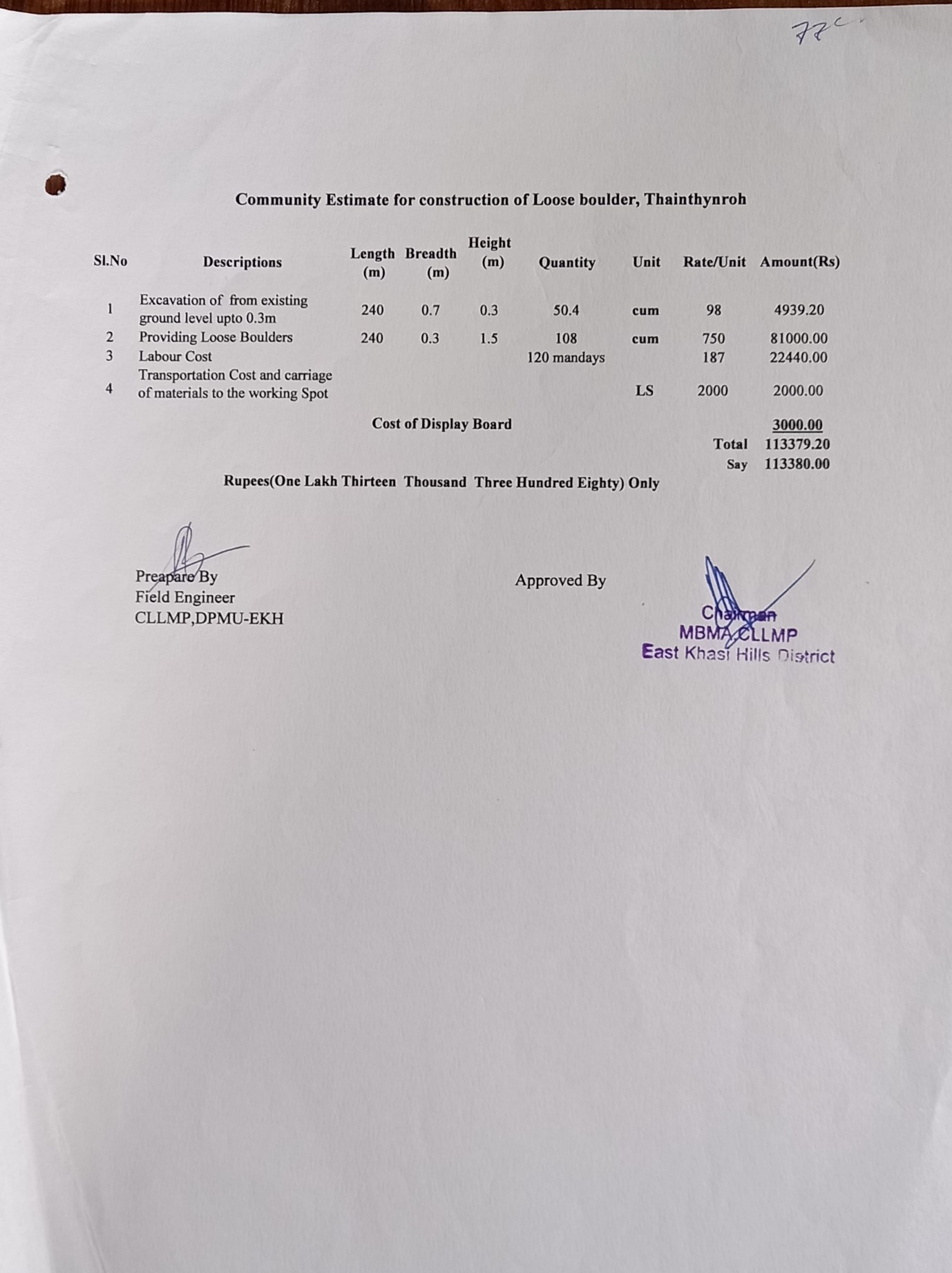
107507 | completed | ||||||
| 4 | Afforestation at 1 site | 1 | 25.425914 91.696250 |
201272 | completed | |||||||
| 5 | Bench Terracing 1 site | 1 | 25.429947 91.6936 |
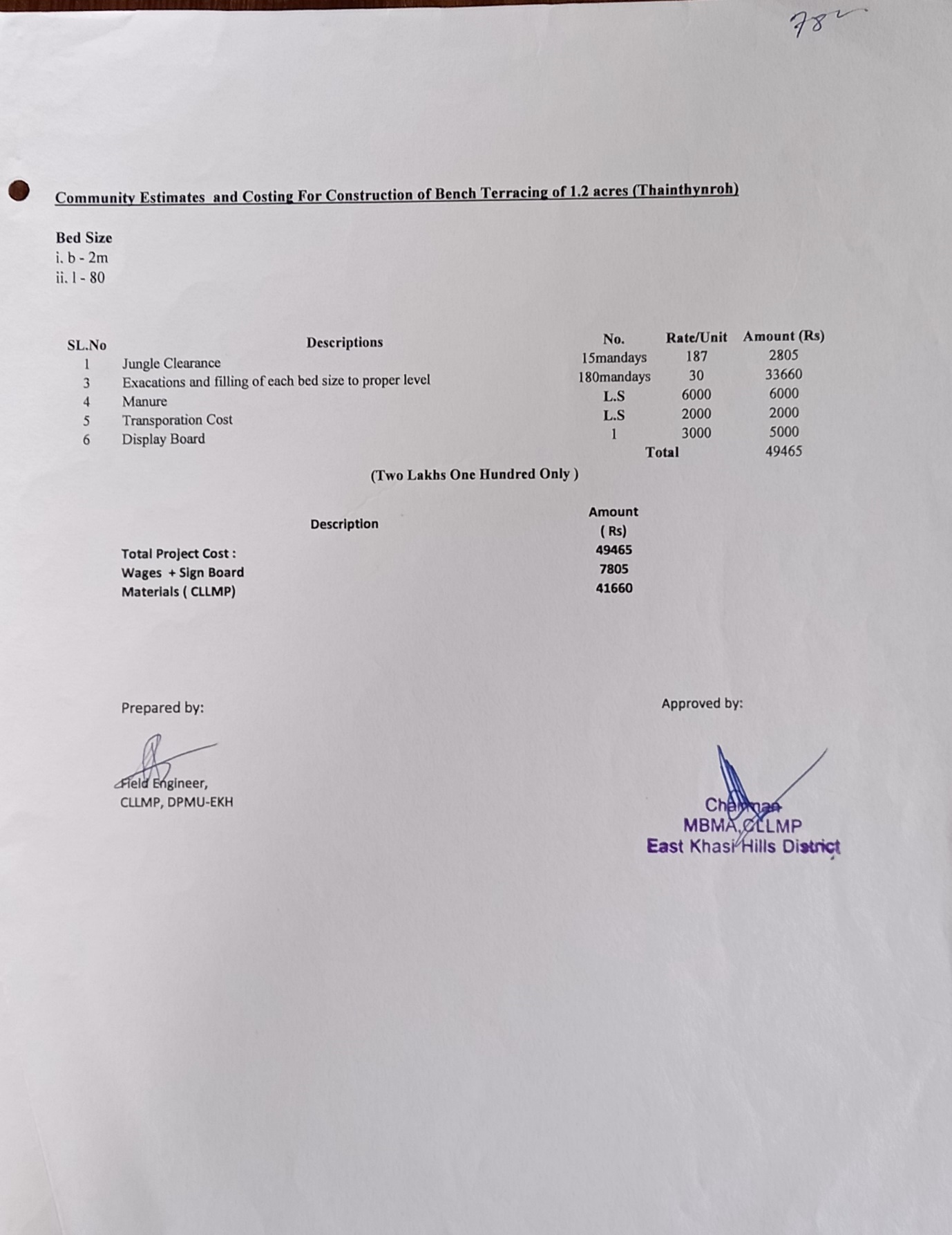
49465 | 1.2 | completed | ||||||
| 6 | Community Nursery at 2 sites | 2 | 25.419464 91.685396 |
758520 | 3200 sqm | completed | ||||||
| 7 | Water Conservation Structure at 1 site | 1 | Umkaber | 25.426124 91.697079 |
435412 | 532950 | completed | |||||
| 8 | Loose Boulder at 1 site | 1 | Raimawlong | 25.4282 91.6942 |
88566 | completed | ||||||
Working Estimates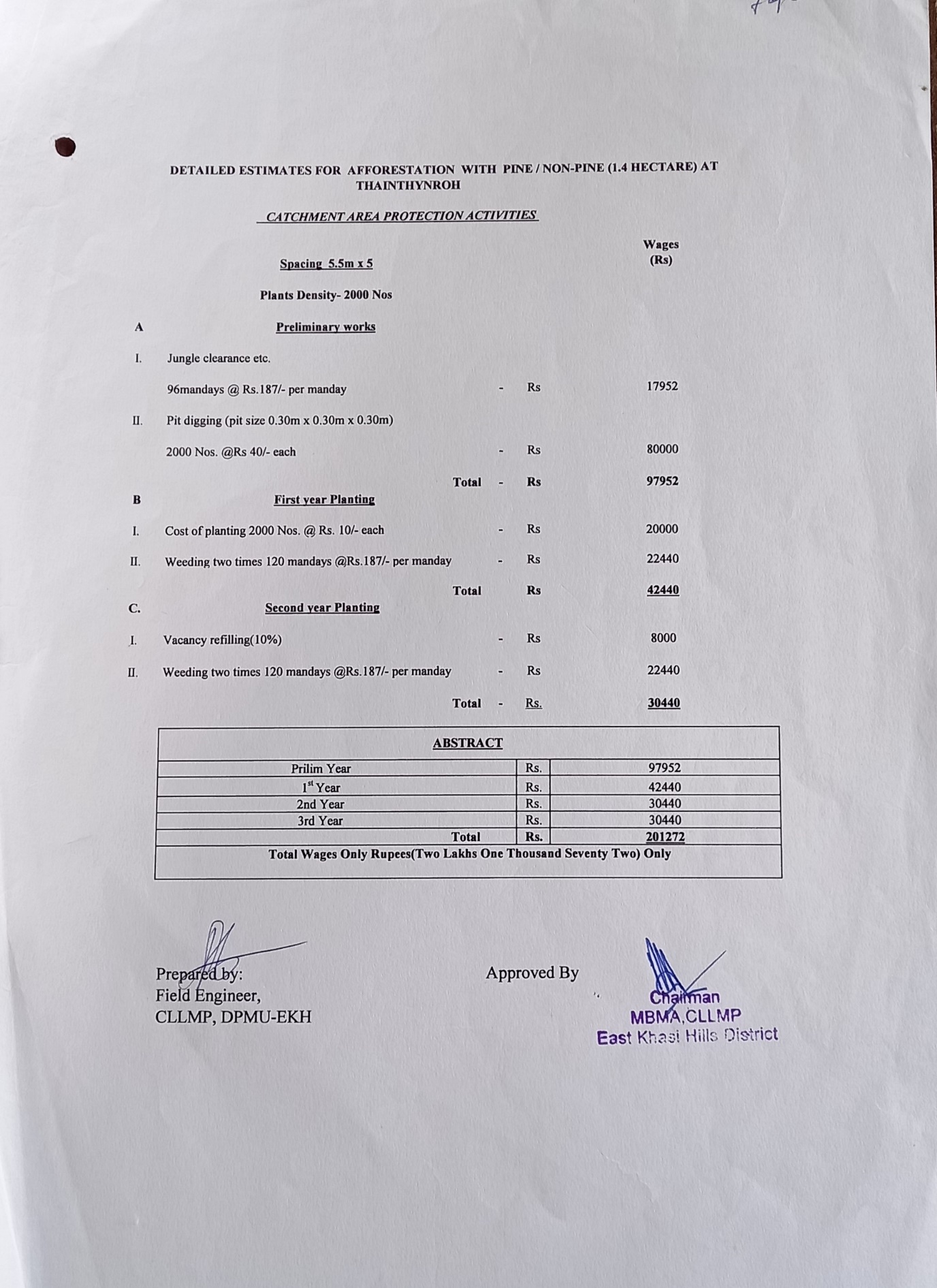
If the answer to the questions posed in the screening process below is ‘Yes’, mitigation measures would be required to be put in place.↩︎
Natural resource (particularly land) ownership and management in Meghalaya is complex – in the presence of customary norms and formal laws. The project intervention will be particularly mindful of such land ownership issues, particularly the nuances of community and private ownership issues. Screening of land sites identified for project interventions: All land for planned interventions would be undertaken on: Existing land available with the implementing agency; Government land accessed through department transfer; Land taken on lease under relevant legal provisions or through voluntary land donation by beneficiaries or taken through lease deed, private market; Purchase agreement or MOU with relevant institutions (like ADCs, Syiems/Nokmas) for community demand driven interventions. No private land acquisition will be undertaken under any project component.↩︎
Voluntary donation of land would be undertaken as per the following principles: That all donors would compulsorily become beneficiaries i.e. no individual or individuals would end up landless and therefore unable to benefit from the demand driven scheme. Such donors are adequately compensated for land given either in cash (at market rates) by purchasing body or given alternate land by contribution from other members. The process of taking such land would involve: Identification of demand from the community followed by assessment of suitability of land as per design; Drawing up of a MOU or agreement with the concerned parties; Such land taken on voluntary donation basis would be duly registered to avoid future complications↩︎
It is to be noted that poverty is not the only indicator that excludes or deprives a person or group from equal access to resources, services and information. Various other indicators such as ethnicity, clan, gender, religion, place of residence, age and others play a very important role in disabling or excluding people from a range of processes and opportunities. CLLMP aims to strengthen the capacities and knowledge of men, women and youths residing in rural Meghalaya. It also aims to ensure that all groups of people in the community are actively involved in the planning, management and monitoring of various initiatives↩︎
The team needs to be cognisant of the possibilities that influx of workers could lead to adverse social and environmental impacts on local communities, especially if the communities are rural, remote or small. Such adverse impacts may include increased demand for goods and services that can lead to price hikes and crowding out of local consumers, increased volume of traffic and higher risk of accidents, increased demands on the ecosystem and natural resources, social conflicts within and between communities, increased risk of spread of communicable diseases, and increased rates of illicit behaviour and crime↩︎
Wherever labour camps will be set up, it will be ensured that the contract labourers are properlydocumented for, the camps have suitable living conditions with safe drinking water, sanitary toilet facilities (earmarked separately for men and women)etc. Contractors’ agreements will have specific clause to ensure child labour and forced labour and banned at project sites, wages are provided as per legal guidelines, labour camp conditions meet adequate quality norms and every contractual employee have proper work-related documentation. The contract should also include clauses regarding reduction of waste general and safe disposal of waste at camp sites; ensure that workers’ camps and associated facilities are connected to septic tank or other wastewater systems which are appropriate and of sufficient capacity for the number of workers and local conditions; avoid contamination of freshwater resources; place workers’ camps away from environmentally sensitive areas to avoid impacts on the local wildlife; route new access routes for workers’ camps to avoid/minimize environmentally sensitive areas; avoid deforestation around camps; provide adequate training to workers on health and safety standards and ensure that children and minors are not employed directly or indirectly on the project↩︎