Village Profile on
Marngor Village under Nongstoin C&RD
Block
District: West Khasi Hills District
7th March, 2021.
COMMUNITY LED LANDSCAPE MANAGEMENT
PROJECT
(CLLMP)


The Government of Meghalaya with financial help from the world Bank is implementing the Meghalaya community Led Landscape Management Project (MCLLMP). The Project will cover the entire State of Meghalaya and implementation of community led plans will be rolled out in phase manner throughout the State. The Meghalaya Basin Management Agency will facilitate community led planning by providing support, technical inputs, and funding.
The project is intended to strengthen community led natural resources management in selected landscape within the 11 Districts of the state .This would be achieved through a variety of planning, capacity building, and on- the ground interventions to promote the conservation sustainable use of natural resources, social inclusion and community mobilization, building traditional knowledge and learning, mapping of natural resources management, strengthening the community institutions and creating linkage with financial institutions and community organizations.
The project interventions will include preparation of community led natural resource management plans. The CLLMP has the following three components:
Strengthening Knowledge and Capacity of communities for Natural resource management.
Community Led- Landscape Planning and Implementation.
Project Management and Governance.
Objective:
 The project objective is
“to manage and conserve the natural resources, especially
forests, soil and water sources, in a manner that supports the
financial and physical well- being of communities in the
State.”
The project objective is
“to manage and conserve the natural resources, especially
forests, soil and water sources, in a manner that supports the
financial and physical well- being of communities in the
State.”
The CLLMP- Programme focuses on increasing the capacities of communities and traditional institutions by adopting a landscape approach to manage their natural resources such as soil, Springs and other water resources forest and bio-diversity etc.
The Project will be planned and implemented in about400 villages across the State
CLLMP has a strong focus on institution building at the village level, by ensuring systematic capacity building on technical and social skill sets
The project also extends such training to communities beyond the targeted villages and support efforts made by them to access funding from various rural and natural resources initiatives and schemes.
The Programme will also invest in improving the process and outcome delivery, by developing adhering to effective systems and procedures, supported by the appropriate technology.
Benefits:
Benefits for community (skills and capacity relating to technical and managerial areas like NRM and conflict resolution
Benefits to traditional institutions (village councils, traditional leaders, community- based organizations, SHGs etc.) through knowledge sharing, promotion of innovative approach, access to technology, technical managerial and financial support.
It is estimated that the project will impact around 1 lakh partners (of which 50% are women) who depend on land, forest, Agro-forestry.
Through the project, 55000 Ha of targeted area will be ensured with availability of water, biological resources, and soil productivity, which will in turn benefit around 400 villages and the outcomes delivery can summarized as follows.
Benefits for community (Skills and Capacity relating to technical and managerial areas like NRM and Conflict resolution
Benefits to traditional institutions (village councils, traditional leaders, community-based organizations, SHGs etc) through Knowledge sharing, promotion of innovative approach, access to technology, technical managerial and financial support.
It is estimated that the project will impact around 1 lakh partners (of which 50% are women) who depend on land, forest, agro forestry.
Through the project, 55000 Ha of targeted area will be ensured with availability of water, biological resources and soil productivity, which will in turn benefit around 400 villages and the outcomes delivery can be summarized as follows.
The Project will be executed by the MBMA in collaboration with other partners particularly, SIRD (for training and capacity building), Department of Soil and Water Conservation, Water Resource Department, Forest Department, specifically with respect to technical inputs, safeguards management and Community NRM plan preparation.
2018-2023 (5 years).
Contents
| Sl. No. | Topics | Page No. |
|---|---|---|
| I. | Introduction & History | 5 |
| II. | Social Profile | 6 |
|
7-9 | |
| III. | CLLMP Activities | 10 |
|
10-27 |
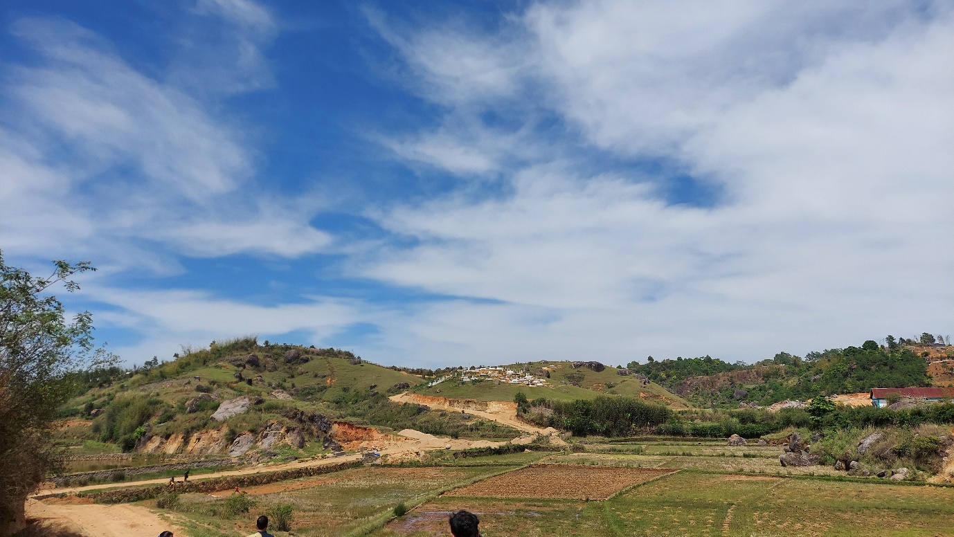
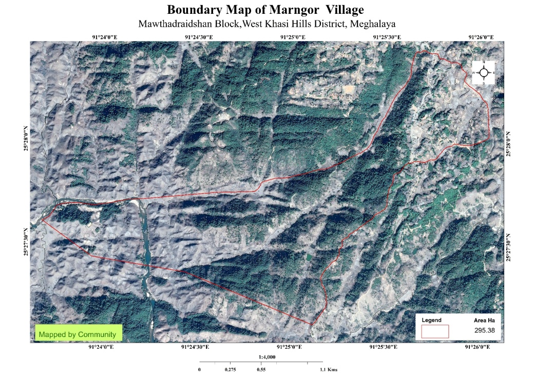
The Marngor village is situated at Nongstoin C&RD Block, West Khasi Hills District. It is 30kms away from Nongstoin, the District headquarter. This village falls under Nongsohphoh Syiemship with a geographical area of 295.38ha. There are 162 household with 1053 villagers out of which 532 are males and 521are females.
 The beginning of the
village Marngor dates to 300 years ago. There is no precise
information in the year it was established. As per folktales, the
British Government assumed that the village was started in the year
1570. In the early days, there were 3 clans who inhabited Marngor-
Sohshang, Iawphaniaw and Lyngkhoi. Initially, the people
first inhabited belonged to the Sohshang clan namely Smt.
Wir sohshang her husband Shri. Mud
Marwein and their five childrens u Nguhelom, ka
Moit, ka Jah, ka Mah and ka Soin and their two maternal
uncles Shri. Wanbit Sohshang and Shri.
Deibeit Sohshang. Later, a lady from Rangblang
named Smt. Rongmai Iawphaniaw came and settled at Marngor followed
by Smt. Laphin Lyngkhoi from Ngunraw. As days passed, the people
from these 3 clans decided to start the indigenous tribal religion
on a rock called Mawseng Shnong which was known as Leishong. The
people of Sohshang clan were the first to perform the rituals.
Marngor village cooperatively worked with the Mawsynrap village
which was started by the Lyngdoh Mawlot clan where Shri. Moitbah
Lyngdoh looked after the Lyngdoh Mawlot Clan and Nguhelom Sohshang
under Sohshang clan for the villages of Mawsaw, Mawsynrap and
Marngor. Later, these three villages decided to established a new
Hima and seek a leader or Syiem from Hima Nongkhlaw to look after
the administration of the village. After this, a lady named Smt.
Maitmakha along with her four children ka shyrpoi, ka ksan, ka Ngoi
and u Long from the village Marong of Hima Nongkhlaw came and
settled. Hence, she named the Hima as Hima Nongsohphoh and the
village Marong as Marngor.
The beginning of the
village Marngor dates to 300 years ago. There is no precise
information in the year it was established. As per folktales, the
British Government assumed that the village was started in the year
1570. In the early days, there were 3 clans who inhabited Marngor-
Sohshang, Iawphaniaw and Lyngkhoi. Initially, the people
first inhabited belonged to the Sohshang clan namely Smt.
Wir sohshang her husband Shri. Mud
Marwein and their five childrens u Nguhelom, ka
Moit, ka Jah, ka Mah and ka Soin and their two maternal
uncles Shri. Wanbit Sohshang and Shri.
Deibeit Sohshang. Later, a lady from Rangblang
named Smt. Rongmai Iawphaniaw came and settled at Marngor followed
by Smt. Laphin Lyngkhoi from Ngunraw. As days passed, the people
from these 3 clans decided to start the indigenous tribal religion
on a rock called Mawseng Shnong which was known as Leishong. The
people of Sohshang clan were the first to perform the rituals.
Marngor village cooperatively worked with the Mawsynrap village
which was started by the Lyngdoh Mawlot clan where Shri. Moitbah
Lyngdoh looked after the Lyngdoh Mawlot Clan and Nguhelom Sohshang
under Sohshang clan for the villages of Mawsaw, Mawsynrap and
Marngor. Later, these three villages decided to established a new
Hima and seek a leader or Syiem from Hima Nongkhlaw to look after
the administration of the village. After this, a lady named Smt.
Maitmakha along with her four children ka shyrpoi, ka ksan, ka Ngoi
and u Long from the village Marong of Hima Nongkhlaw came and
settled. Hence, she named the Hima as Hima Nongsohphoh and the
village Marong as Marngor.
Marngor village has a total number of 1053 villagers of which 532 are males and 521 are females. The village has 105 children between the age group of 0-4 years. Among them 61 are boys and 44 are girls.
Village Accessibility:
In order to reach Marngor, one must venture through Nongkasen road; one need to turn right at a taxi stop. Upon reaching the village name Laitkseh, one must turn left in order to reach Marngor.
Literacy: As per 2011 census, the literacy rate of Marngor has touched to the tune of 84.2%. There are three schools in the village.
Presently the village is managed and guided by its active Dorbar as the highest authority in the village which alternatively comprised of the Seng Kynthei (Women Wing) and Seng Samla (Youth Wing) all collectively aiming for the overall development and growth of the village. Other committees are:
Village Employment Council
Water and Sanitation Committee
 Self
Help Groups are active and constantly working together for the
betterment of the village.
Self
Help Groups are active and constantly working together for the
betterment of the village.
1. Population: Marngor village has a total number of 1053 villagers in the community. Out of this, 532 are males while the female count is 521. The village has 105 children between the age group of 0-4 years. Among them 61are boys and 44 are girls.
| Age group | Male | Female | Total |
|---|---|---|---|
| 0-4 | 61 | 44 | 105 |
| 5-14 | 155 | 116 | 271 |
| 15-30 | 209 | 200 | 409 |
| 30-60 | 96 | 110 | 206 |
| Above 60 | 11 | 51 | 62 |
BPL/APL Household:
| Particulars | NO. of HHs |
|---|---|
| BPL HH | |
| APL HH |
2. Card Holding Household:
| Particulars | No. of Household |
|---|---|
| Total HH | 162 |
| Ration Card HH |
Fuel Type:
| Fuel Type | Total HH |
|---|---|
| Charcoal | 10 |
| Wood | 130 |
| LPG | 22 |
| Kerosene | 0 |
 Occupation:
The people of the village rely on agriculture and forest products
for their livelihood. The main occupation of the villagers is
farming followed by teaching, self-employed and government
service.
Occupation:
The people of the village rely on agriculture and forest products
for their livelihood. The main occupation of the villagers is
farming followed by teaching, self-employed and government
service.

4. Key Constraints: There is scarcity of water and the village mostly depend on springs for drinking and streams for other domestic use.
5. Water bodies: There is scarcity of water and the village mostly depend on springs for drinking and streams for other domestic uses.
Spring-7 Streams-5, Rivers- 2.
Forest- 98.62 ha.
1. Ground Truthing:
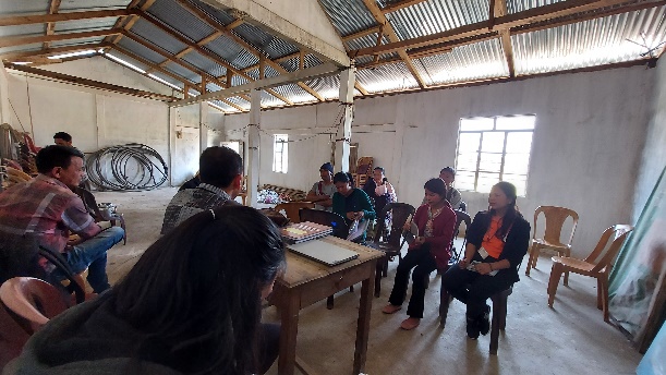
On 10th December, 2019, the District Project Management Unit and other CLLMP officials visited Marngor village for ground truthing under the presence of Shri. Bilkstar Sohshang, the Headman of Marngor Village and other representatives for field assessment. The Headman provided the team with important information regarding the current scenario of the landscape and the natural resource management under his Headmanship.
Case Findings:
The village has 162 household, out of which ------- HH falls under BPL and ------HH falls under APL.
Few patches of degraded land which are fallow and barren.
Burning of forest in winter season which leads to the loss of natural vegetation.
Availability of spring which is the source of water supply.
Actively performing VEC.
2. Sensitization Programme:
The Sensitization Programme of Marngor village was conducted on 20th January, 2020, where the District Project Manager and other CLLMP officials emphasized on the Community Led Landscape Management Project. A total of 70 Villagers participated in the program, voiced out their concerns and questions regarding the project making it a huge success.
Highlights of the Meeting:
Awareness about community-Landscape Management Project.
Laying importance on the involvement of the community in making the CNRM plan and its success.
A brief awareness on cleanliness was conducted based on the findings during the ground truthing phase.
An interactive session was held to answer the doubts of the villagers regarding the project.
2.1. Signing of EOI, VGA and Green Charter:
Marngor village signed the Expression of Interest (EOI), the village Grant Agreement (VGA) and the Green Charter after there was a uniform agreement by the entire community that the Community Led landscape Management Project CLLMP be implemented at Marngor village.
2.2. Formation of VNRMC:
The formation of the Village Natural Resource Management Committee was done on the in a public meeting in the Presence of the entire village and the CLLMP staffs. The Community chose the President the secretary and the other executive members of the committee
| Village Natural Resource Management Committee (9member committee constituted from Village Council and VEC, SHG group, Women’s group, youth;4 members should be women) | ||||||||
|---|---|---|---|---|---|---|---|---|
| Sl No | Name in Full | Gender M/F | Age (in Yrs) | Education | Designation | Occupation | Community | Contact No |
| 1 | Blikstar Sohshang | M | 56 | XII | President | Teacher | Khasi | 8787530462 |
| 2 | Gracefulness Lyngdoh | F | 24 | B.COM | Secretary | Housewife | Khasi | 8837444811 |
| 3 | Broly Iawphniaw | M | 45 | BA | Finance Secretary | Teacher | Khasi | 8837343548 |
| 4 | Briksuis Marwein | M | 70 | X | Member | Retired | Khasi | 6009672819 |
| 5 | Bistar Sohshang | M | 53 | BA | Member | Teacher | Khasi | 8787705677 |
| 6 | Holdes Sanglyne | M | 55 | XII | Member | Teacher | Khasi | 8787549935 |
| 7 | Jenevive Sanglyne | F | 45 | BA | Member | Teacher | Khasi | 7005381116 |
| 8 | Ibarilin Sohshang | F | 27 | X | Member | SHG | Khasi | 9862994647 |
| 9 | Badashisha Sohshang | F | 25 | X | Member | Business | Khasi | 7005827204 |

Fig. 1: VNRMC Members.
| Village Community Facilitators | ||||||
|---|---|---|---|---|---|---|
| Sl. No | Name | Gender | Age | Education | Contact Number | Role |
| 1 | Bosly sohshang | M | 32 | X | 7005927634 | VCF Environment |
| 2 | Mishal Sohshang | M | 24 | XII | 9366716329 | VCF Social |
| 3 | Batelsha Lyngdoh | F | 27 | BA | 6009260282 | VCF Documentation |
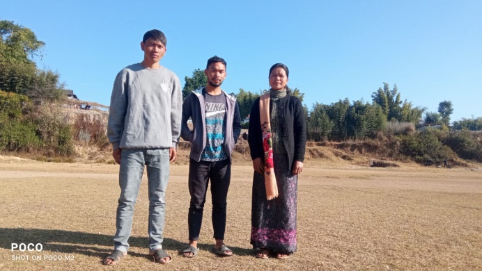
Fig. 2: VCFs of Marngor.
| List of Procurement Members | |||||
|---|---|---|---|---|---|
| Sl.No | Name | Gender | Age | Education | Contact Number |
| 1 | Badashisha Sohshang | F | 25 | X | 7005827204 |
| 2 | Bainestone L. Nonglait | M | 45 | BA | 8787743081 |
| 3 | Binest l. Mawlot | M | 45 | BA | 7005457976 |
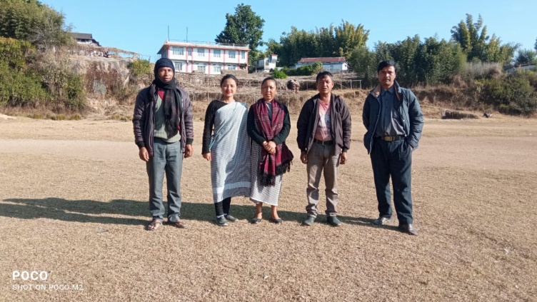
Fig3: The Procurement Committee Members of Marngor
3. Opening of Bank Account:
The opening of bank account was on done the 4th March, 2020, after the signing of the EOI (Expression of Interest), the Village Grant Agreement (VGA) and the signing of Green Charter (GA) at the respective villages.
A meeting was held for all the VNMRC members of Marngor to brief and assist them before opening the VNMRC bank account. The bank account was opened on 4th March 2020.
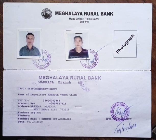
Fig 4: Bank Account passbook
4. Participatory Rural Appraisal:
The PRA aims to incorporate the knowledge and opinions of the community in the planning and management of development projects and programs. The PRA exercise at Marngor village took place on the 28th Feb, 2020, where a total of 60 villagers both men and women took part in the exercise.
The initial stage of Participatory Rural Appraisal exercise at Marngor village commenced with a meeting cum orientation program on CLLMP. While conducting the meeting, the community members were made aware of the various PRA exercise conducted for the development of Community Natural Resource Management Plan (CNRMP) of the village, the community members contribution in the exercise and the objective to be achieved. The key informants- the VNMRC and the VCFs helped facilitate maximum participation.
Commencement of PRA:
Introduction:
Participatory Rural Appraisal is the process of involving local people in the analysis and interpretation of their own situation of a given rural area. The local people i.e., the participants take a leadership role in collecting, analyzing, interpreting, and presenting information and in this process impart knowledge and development insight to the specialist and extension agents for management of natural resources. Participatory Rural Appraisal is conducted to establish rapport with the village community as well as to identify and define problems for prioritization in the village itself. It is a way of learning from and with community members to investigate their need assessment, analyze and evaluate constraints and opportunities and find out priorities in the area of agriculture, small scale rural enterprises and any other social and economic development programs addressed to village development based on the principle of listening and learning.
Objectives of PRA exercise at Marngor village:
The Participatory Rural Appraisal exercise at Marngor was conducted with following objectives:
To identify the natural human and economic resources of village
To identify the village problems and prioritize them with the help of community members.
To prepare the community natural resource Management Plan of the village.
Activity 1: Village Boundary Mapping and Drawing the Resource Map:
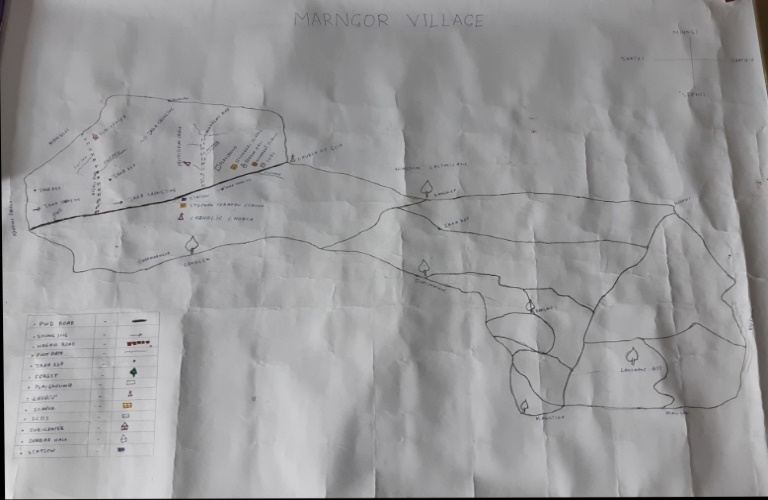
The GIS personnel along with the Village Community Facilitators mapped the village boundary of Marngor village. The second step is to involve the local community in preparation of village resource map as perceived by the community members to solicit their participation, infrastructure, services, and other village resources such as agricultural lands, wells, wasteland, cattle, population etc., were mapped. Local people prepared the resource map by drawing it on a chart paper without much interference of outsiders.
The activity achieved the following purposes:
Rapport building and won the confidence of the villagers.
Analyzed the spatial information particularly studied problems and opportunities of villagers.
Got an impression about the village setting physical layout location of various houses and institutions.
Finding based on the Resource Map of Marngor village:
Main agriculture produce is squash, potato, paddy, maize, mustard leaf.
Available of Private and clan forest.
Presence of barren land.
Presence of community hall.
There are three schools.
There are 7 springs in the village.
Presence of Integrated Child Development Services (ICDS).
There are two churches in the village.
Presence of football ground.
Presence of health Sub Centre.
Habitation is not confined to one place but spread all over the village.
Activity 2: Baseline Data survey to fill the Environment and social Template:
During the PRA exercise, the External Experts of Social & Environment Management held group discussion with different groups to gather basic village information regarding number of households, demographic information, major crops, and enterprises taken in the village trends of production and productivity of major crops in the village and demographic distribution of village population. Information related to land use category such as forest, cultivable land, water bodies, etc., and problems and challenges related to NRM were discussed.
Activity 3: Focused Group Discussion on Problem Analysis:
Do people have sufficient access to supply of fodder, fuel wood, leaf litter?
No, the people do not have sufficient access to fodder, fuel wood and leaf litter.
Has access to timber has reduced over the years? How is access for household use and commercial use managed?
Access to timber has reduced over the years. People in the village get only from private land which is not sufficient, they must purchase when needed.
Are the water bodies facing any threats?
Yes.
Do all people in the village have access to drinking water? What are the challenges?
No, the people in the village does not have access to drinking water especially in winter season.
Are there any degraded areas in the village (open/ degraded forests, mining affected, high soil erosion etc.)?
Yes, there are some degradations in cultivated and forest land.
What has caused this degradation? Are there practices causing threats to availability and access to natural resources?
Burning of forest and deforestation
What have been the changes in agricultural practices?
Yes.
Are there any challenges in farming?
Yes, one of the main reasons is marketing.
How would you consider the health situation in your village?
Good due to the presence of Health sub center.
How is the situation of cleanliness, sanitation, access to toilets and waste management?
Cleanliness, sanitation, access to toilets is improving due to the presence of VWSC but the level of awareness on waste management is unsatisfactory.
Who are the most vulnerable in the village? What can be done to improve their lives?
BPL.
What are the livelihood aspirations of the youth? Are there any avenues available?
Proper employment for their livelihood.
Do any committees/ Institutions/ rules exist to manage and monitor natural resource in the village?
Executive committee of the village Dorbar
What are some of the major issues of conflict in the village?
NA.
Have any of the above issues been discussed in village meetings?
NA.
How do people resolve disagreement and conflicts?
All disagreements and conflicts are addressed by the traditional institution of village called the Village Dorbar and mutual understanding.
Activity 4: Seasonal Calendar:
The CLLMP team also mapped the seasonal calendar of Marngor village to help identify heavy workload periods, periods of relative ease, credit crunch, diseases, food security, wage availability etc. This will prove helpful in project planning and project timeline framing.
| Seasonal Calendar | |||||||||||||
|---|---|---|---|---|---|---|---|---|---|---|---|---|---|
| Sl.no | criteria | Jan | Feb | Mar | Apr | May | Jun | Jul | Aug | Sep | Oct | Nov | Dec |
| 1 | Water Scarcity | 1 | 1 | 3 | 2 | ||||||||
| 2 | Prone to sickness | 2 | 1 | 1 | 2 | ||||||||
| 3 | Seeking job outside | 1 | 2 | 1 | |||||||||
| 4 | Rainfall | 1 | 1 | 2 | |||||||||
| 5 | Free-less work | ||||||||||||
| 6 | Paddy cultivation | 1 | 1 | ||||||||||
| 7 | Paddy harvesting | 1 | 1 | ||||||||||
| 8 | Tree plantation | 1 | 1 | ||||||||||
| 9 | Vegetable crop plantation | 1 | 1 | 2 | 2 | ||||||||
| 10 | Vegetable harvesting | 3 | 2 | 1 | 2 | 1 | |||||||
| 11 | Festive season | 1 | 2 | 2 | 1 | ||||||||
| 12 | Forest fire | ||||||||||||
| 13 | Collection of wood | 1 | 3 | 2 | 1 | 1 | |||||||
| Maximum | 1 |
|---|---|
| Medium | 2 |
| Low | 3 |
5: Submission of CNRMP:
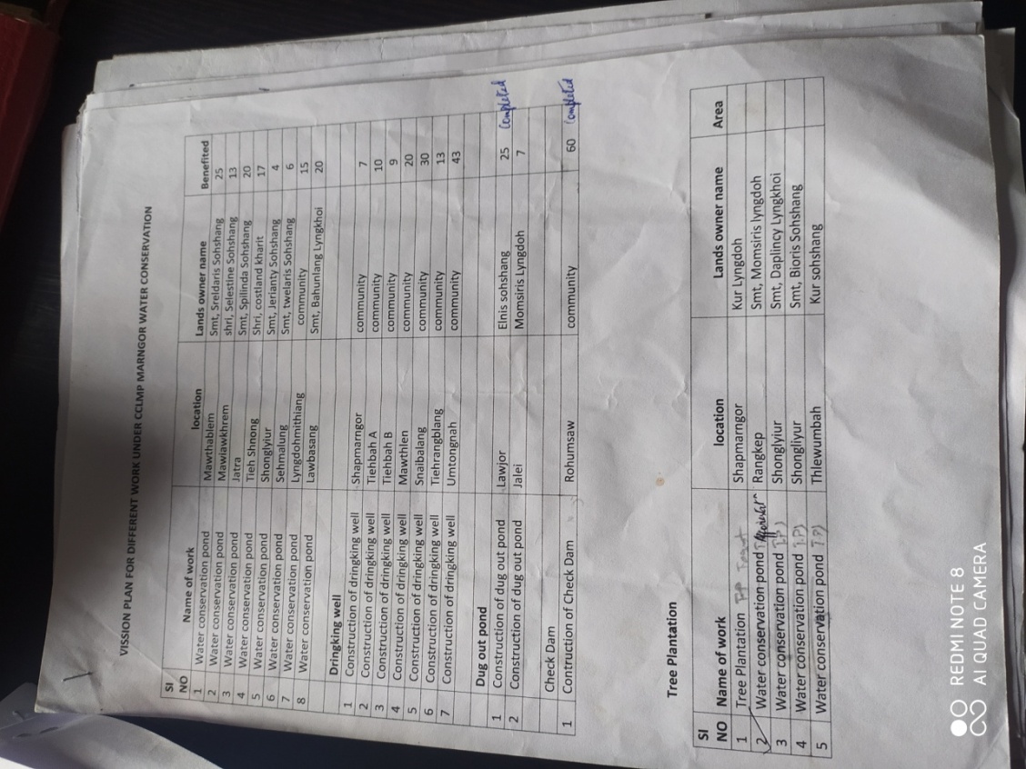
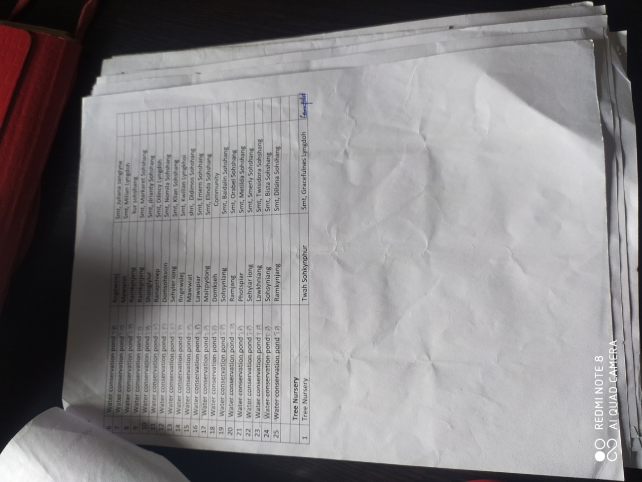
5:1 The Final Community Natural Resource Management Plan:
| Sl.No | Name of proposed intervention | Site | Land ownership | Nos of HHS EXPECTED TO Benefit | Priority | ||
|---|---|---|---|---|---|---|---|
| BPL | APL | Total | |||||
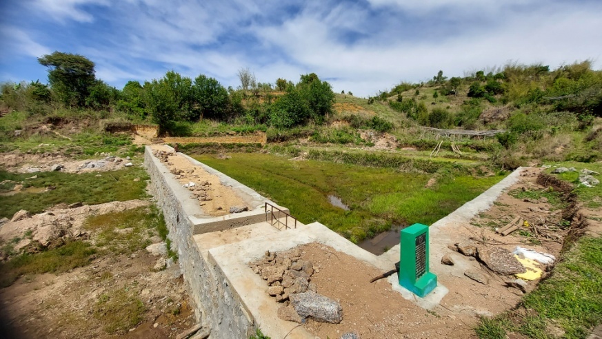
| 1 | Water conservation pond | Mawthablem | Private | 15 | 10 | 25 | High |
| 2 | Water conservation pond | Mawiawkhrem | Private | 7 | 6 | 13 | High |
| 3 | Water conservation pond | Jatra | Private | 10 | 10 | 20 | High |
| 4 | Water conservation pond | Tiehshnong | Private | 10 | 7 | 17 | High |
| 5 | Water conservation pond | Shonglyiur | Private | 2 | 2 | 4 | High |
| 6 | Water conservation pond | Sehmalung | Private | 3 | 3 | 6 | High |
| 7 | Water conservation pond | Lyngdohmithiang | Community | 10 | 5 | 15 | High |
| 8 | Water conservation pond | Lawbasang | Private | 10 | 10 | 20 | High |
| 9 | Construction of drinking well | Sharpmarngor | Community | 5 | 2 | 7 | High |
| 10 | Construction of drinking well | Tiehbah A | Community | 5 | 5 | 10 | High |
| 11 | Construction of drinking well | Tiehbah B | Community | 5 | 4 | 9 | High |
| 12 | Construction of drinking well | Mawthlen | Community | 10 | 10 | 20 | High |
| 13 | Construction of drinking well | Snaibalang | Community | 15 | 15 | 30 | High |
| 14 | Construction of drinking well | Tiehrangblang | Community | 6 | 7 | 13 | High |
| 15 | Construction of drinking well | Umtongnah | Community | 23 | 20 | 43 | High |
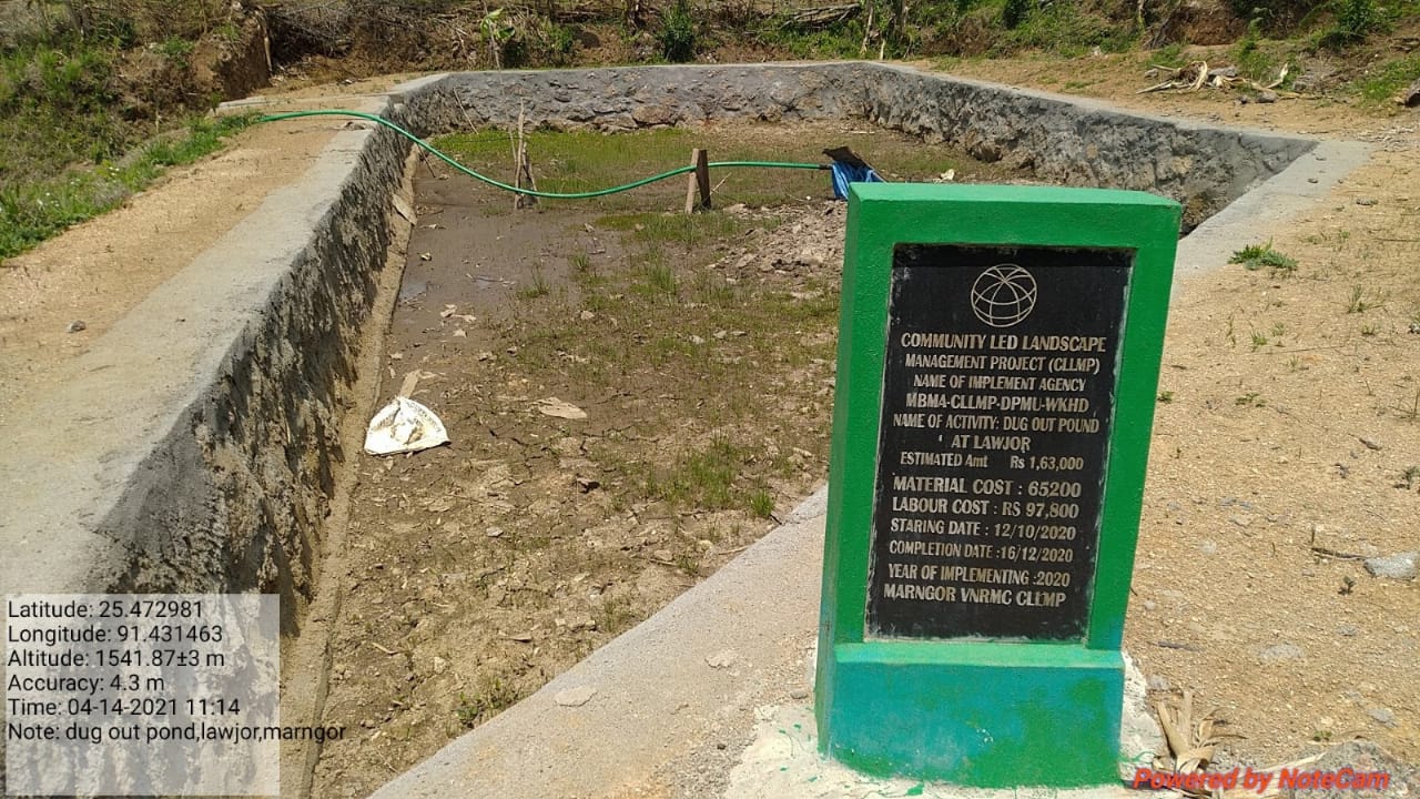
| 16 | Construction of dug out pond | Lawjor | Private | 20 | 5 | 25 | High |
| 17 | Construction of dug out pond | Jalei | Private | 4 | 3 | 7 | High |
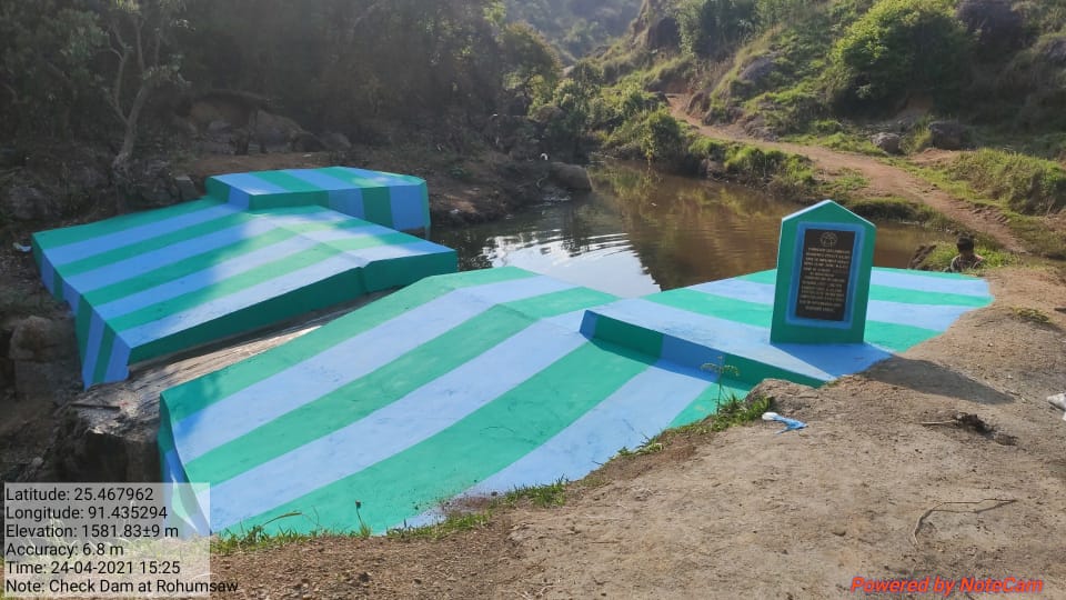
| 18 | Check dam | Rohumsaw | Community | 40 | 20 | 60 | High |
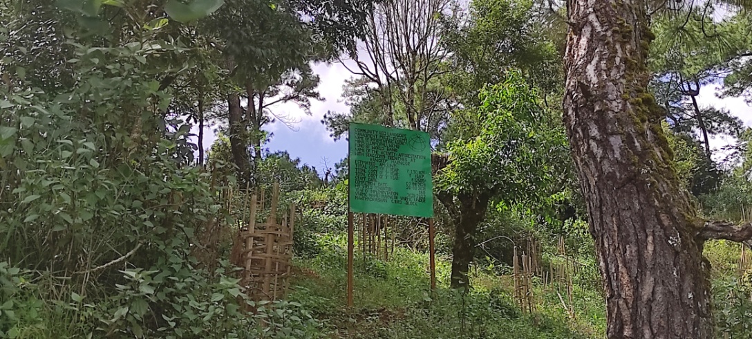
| 19 | Tree plantation | Sharpmarngor | clan | High | |||
| 20 | Water conservation pond | Rangkhep | Private | High | |||
| 21 | Water conservation pond | Shonglyiur | Private | High | |||
| 22 | Water conservation pond | Thlewumbah | clan | High | |||
| 23 | Water conservation pond | Rngiewsiej | private | High | |||
| 24 | Water conservation pond | Mawwiat | private | High | |||
| 25 | Water conservation pond | Ramkynjang | clan | High | |||
| 26 | Water conservation pond | Ramkynjang | private | High | |||
| 27 | Water conservation pond | Shonglyiur | private | High | |||
| 28 | Water conservation pond | Ranapthiep | private | High | |||
| 29 | Water conservation pond | Domsohksoin | Private | High | |||
| 30 | Water conservation pond | Sehyieriong | Private | High | |||
| 31 | Water conservation pond | Rngiewsiej | private | High | |||
| 32 | Water conservation pond | Mawiat | Private | High | |||
| 33 | Water conservation pond | Lawspiar | Private | High | |||
| 34 | Water conservation pond | Maitpydong | Private | High | |||
| 35 | Water conservation pond | Domkseh | clan | High | |||
| 36 | Water conservation pond | Sohsyniang | Private | High | |||
| 37 | Water conservation pond | Ramjang | Private | High | |||
| 38 | Water conservation pond | Photspiar | Private | High | |||
| 39 | Water conservation pond | Sehyariong | Private | High | |||
| 40 | Water conservation pond | Lawkhniang | Private | High | |||
| 41 | Water conservation pond | Sohsyniang | Community | High | |||
| 42 | Water conservation pond | Ramkynjang | Private | High | |||
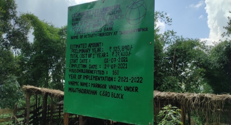
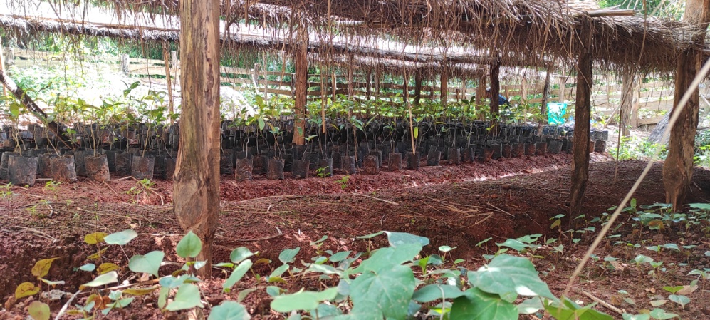
| 43 | Tree nursery | Twasohkynphur | Private | High | |||
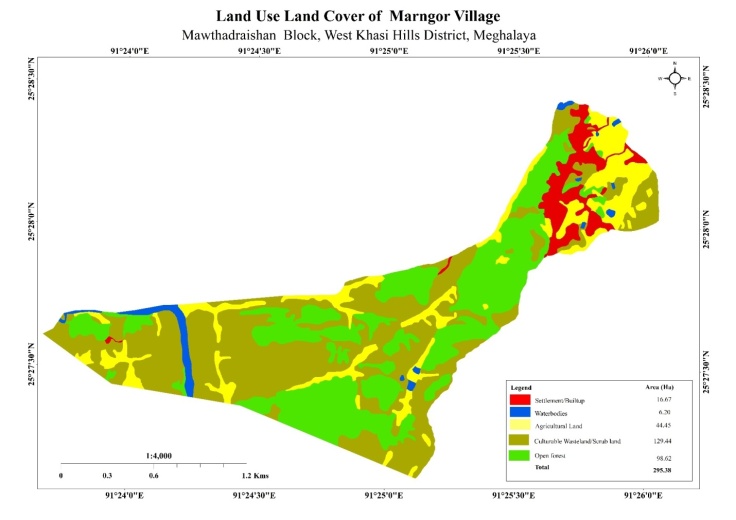
6: GIS Activities:
| Sl.No | Parameters | Village informaton |
|---|---|---|
| 1 | GPS Coordinates | |
| i | Latitude | 25.469237 |
| ii | Longitude | 91.427538 |
| iii | Elevation Reading (MSL) | 1613 |
| 2 | Village Geographical Area (Ha) | 295.38 ha |
| i | Total Forest Area including community,clan,pvt forest) | 98.62 ha |
| ii | Total area of water bodies | 6.20 ha |
| iii | Total area under agri-Horticulture | 44.45 ha |
| iv | Total degraded land area (Ha) | 31.5 ha |
| 3 | Average annual rainfall | |
| 4 | Soil Type |
7: Project implementation
| 1. | Type of Intervention | Site Name | GPS- Coordinates | Amount Sanctioned | Work status | |
|---|---|---|---|---|---|---|
| Water Conservation Pond | Mawthablem | 25.473268 | 91.430437 | 312600 | Completed | |
| 2. | Type of Intervention | Site Name | GPS- Coordinates | Amount Sanctioned | Work status | |
|---|---|---|---|---|---|---|
| Dug Out Pond | Lawjor | 25.47295167 | 91.43149944 | 163000 | Completed | |
| 3. | Type of Intervention | Site Name | GPS- Coordinates | Amount Sanctioned | Work status | |
|---|---|---|---|---|---|---|
| Check dam | Rohumsaw | 25.4678875 | 91.43524194 | 405300 | Completed | |
| 4. | Type of Intervention | Site Name | GPS- Coordinates | Amount Sanctioned | Work status | |
|---|---|---|---|---|---|---|
| Nursery | Twasohkynphur | 25.47138528 | 91.42817028 | 153500 | Completed | |
| 5. | Type of Intervention | Site Name | GPS- Coordinates | Amount Sanctioned | Work status | |
|---|---|---|---|---|---|---|
| Afforestation | Rangkep | 25.45855167 | 91.42112583 | 160200 | Completed | |
| 6. | Type of Intervention | Site Name | GPS- Coordinates | Amount Sanctioned | Work status | |
|---|---|---|---|---|---|---|
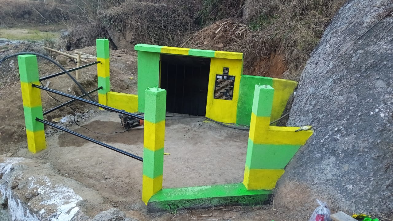
| Spring Chamber | Tiehbah | 25.46783 | 91.43061 | 34072 | Completed | |
| 7. | Type of Intervention | Site Name | GPS- Coordinates | Amount Sanctioned | Work status | |
|---|---|---|---|---|---|---|
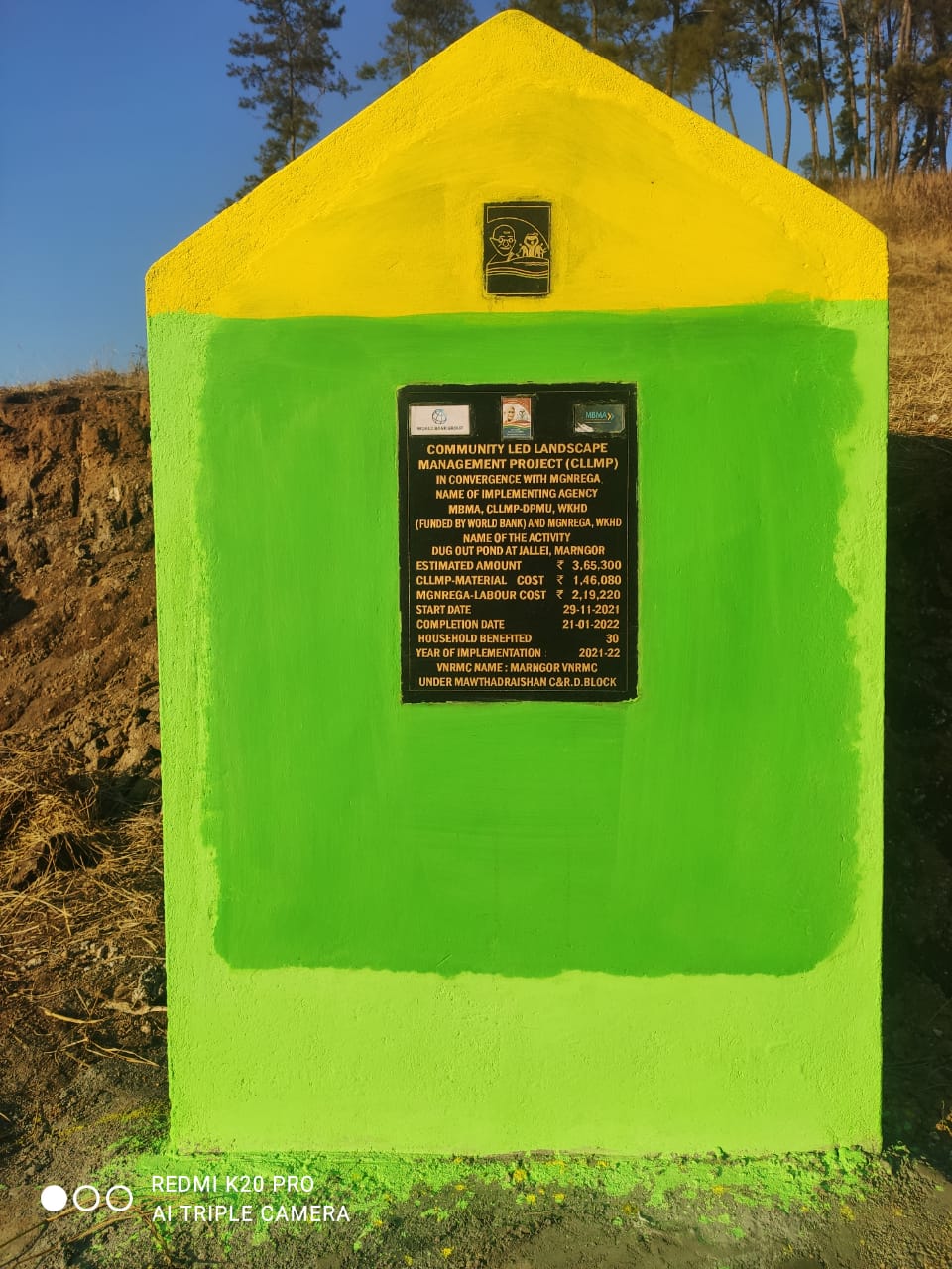
| Dug out pond | Jallei | 25.466349 | 91.440972 | 146080 | Completed | |
8. Fund Status:
| Fund released to VNRMC (Project Implementation | Total No. of work order issued | Total amount issued under CLLMP (per Activity) | Total Amount spent | Start Date | End Date |
|---|---|---|---|---|---|
| ₹26,42,554 | 17 | Dug Out Pond | 1,63,000 | 05-Oct-20 | 16-Dec-20 |
| Water Conservation Pond | 3,12,600 | 05-Oct-20 | 19-Dec-20 | ||
| Check Dam | 4,05,300 | 08-Mar-21 | 24-Apr-21 | ||
| Community Nursery | 1,53,500 | 08-Jun-21 | 24-Jul-21 | ||
| Afforestation with Staggered trenches (Afforestation) | 1,38,538 | 07-Aug-21 | 26-Aug-21 | ||
| Afforestation with Staggered trenches (Trenches) | 9,216 | 07-Aug-21 | 26-Aug-21 | ||
| Spring Chamber | 34,072 | 29-Nov-21 | 19-Jan-22 | ||
| Dug Out Pond | 1,46,080 | 29-Nov-21 | 21-Jan-22 | ||
| Spring Chamber | 85,500 | 10-Mar-22 | 18-Apr-22 | ||
| Spring Chamber | 85,500 | 10-Mar-22 | 18-Apr-22 | ||
| Water Conservation Pond | 4,90,300 | 05-May-22 | 31-Aug-22 | ||
| Establishment of Afforestation (Afforestation) | 1,46,592 | 08-Jun-22 | 30-Jun-22 | ||
| Establishment of Afforestation (Trenches) | 4,608 | 08-Jun-22 | 30-Jun-22 | ||
| Construction of 4 units Vermi Compost | 1,55,000 | 01-Aug-22 | 17-Sep-22 | ||
| Spring Chamber | 93,300 | 14-Nov-22 | 14-Jan-23 | ||
| Spring Chamber | 85,500 | 01-Nov-22 | 31-Dec-22 | ||
| Water Harvesting Tank | 1,33,948 | 01-Nov-22 | 31-Dec-22 | ||
| Total amount spent | ₹26,42,554 | ||||