Village Profile on
Mawlangkhar Village under Nongstoin C&RD
Block
District: West Khasi Hills District
8th February, 2021.
COMMUNITY LED LANDSCAPE MANAGEMENT
PROJECT
(CLLMP)


The Government of Meghalaya with financial help from the world Bank is implementing the Meghalaya Community Led Landscape Management Project (MCLLMP). The Project will cover the entire State of Meghalaya and implementation of community led plans will be rolled out in phase manner throughout the state. The Meghalaya Basin Management Agency will facilitate community led planning by providing support, technical inputs, and funding.
The project is intended to strengthen community led natural resources management in selected landscape within the 11 Districts of the state. This would be achieved through a variety of planning, capacity building, and on- the ground interventions to promote the conservation sustainable use of natural resources, social inclusion, and community mobilization, building traditional knowledge and learning, mapping of natural resources management, strengthening the community institutions and creating linkage with financial institutions and community organizations.
The project interventions will include preparation of community led natural resource management plans. The CLLMP has the following three components:
Strengthening Knowledge and Capacity of communities for Natural resource management
Community Led- Landscape Planning and Implementation
Project Management and Governance
Objective:
The project objective is “to manage and conserve the natural resources, especially forests, soil and water sources, in a manner that supports the financial and physical well- being of communities in the State.”
The CLLMP- Programme focuses on increasing the capacities of communities and traditional institutions by adopting a landscape approach to manage their natural resources such as soil, Springs and other water resources forest and bio-diversity etc.
The Project will be planned and implemented in about400 villages across the State
CLLMP has a strong focus on institution building at the village level, by ensuring systematic capacity building on technical and social skill sets
The project also extends such training to communities beyond the targeted villages and support efforts made by them to access funding from various rural and natural resources initiatives and schemes.
The Programme will also invest in improving the process and outcome delivery, by developing adhering to effective systems and procedures, supported by the appropriate technology.
Benefits:
Benefits for community (skills and capacity relating to technical and managerial areas like NRM and conflict resolution
Benefits to traditional institutions (village councils, traditional leaders, community- based organizations, SHGs etc.) through knowledge sharing, promotion of innovative approach, access to technology, technical managerial and financial support.
It is estimated that the project will impact around 1 lakh partners (of which 50% are women) who depend on land, forest, Agro-forestry.
Through the project, 55000 Ha of targeted area will be ensured with availability of water, biological resources, and soil productivity, which will in turn benefit around 400 villages and the outcomes delivery can summarized as follows.
The Project will be executed by the MBMA in collaboration with other partners particularly, SIRD (for training and capacity building), Department of Soil and Water conservation, Water Resource Department, Forest Department, specifically with respect to technical inputs, safeguards management and community NRM plan preparation.
2018-2023(5 years).
| Sl. No. | Topics | Page No. |
|---|---|---|
| I. | Introduction & History | 5 |
| II. | Social Profile | 6 |
|
7-9 | |
| III. | CLLMP Activities | 10 |
|
10-28 | |
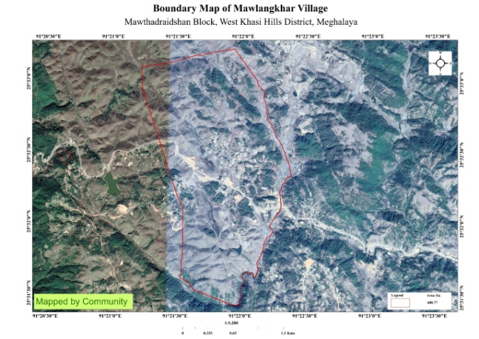
Mawlyngkhar village is situated at Nongstoin C&RD Block, West Khasi Hills District. It is 14kms from Nongstoin, the District Headquarters. The village is known for its rolling hills or dunes. It was founded in 1980 and falls under Hima Myriaw with a total geographical area of 400.77ha. There are about 104 household and a total population of 615 villagers.
In the beginning, Mawlangkhar was part of Nongspung village which falls under Hima Myriaw but later The Dorbar shnong of Nongspung appointed a new acting Sordar Shri. Relshon Nongsiej in the year 1980. From then on, Mawlangkhar was no longer part of Nongspung; culminated to a newly established village. Initially, the total number of households was 12 and the people of this village named the village as Mawlangkhar after a rock Dommaw where on top of the rock were tiny pebbles in which the people used to pick or collect (khar) and hence till date this village is known as Mawlangkhar.
Mawlangkhar has a total number of 104 households and a total population of 615. Majority of the people depend on agriculture and other allied activities as a part of their livelihood where as some others are enrolled in Government and teaching jobs while few inhabitants are engaged in local businesses.
Village Accessibility:
The village is accessible by road ways which is 14kms away from the district headquarter Nongstoin. The village lies on the left side from Nongstoin to Shillong Road which is pleasantly scenic and known for its rolling hills or dunes.
Literacy: As per the 2011 census, the village literacy rate has touched to the tune of 74%. There are two schools in the village- 1 Lower primary and 1 Upper Primary School.
Presently the village is managed and guided by its active Dorbar as the highest authority in the village which is alternatively comprised of the Seng Kynthei,(Womens Wing) and Seng Samla (Youth Wing) all collectively aiming for the overall good and growth of the village. Other communities such as Village Employment Council (VEC), Village Water and Sanitation Committee, Village Organization (VO) and Self- Help groups are constantly active working in due cooperation between themselves for the future of the village.
 1.
Population: As per 2011 census,Mawlangkhar village has
a total number of 407 peoples. Presently, the population has
increased to 578 of which 309 are males and 269 are females. This
village has 80 children in the age group of 0-4 years. Among them 42
are boys and 38 girls.
1.
Population: As per 2011 census,Mawlangkhar village has
a total number of 407 peoples. Presently, the population has
increased to 578 of which 309 are males and 269 are females. This
village has 80 children in the age group of 0-4 years. Among them 42
are boys and 38 girls.
| Age group | Male | Female | Total |
|---|---|---|---|
| 0-4 | 34 | 44 | 78 |
| 5-14 | 89 | 92 | 181 |
| 15-30 | 93 | 91 | 184 |
| 30-60 | 73 | 67 | 140 |
| Above 60 | 13 | 19 | 32 |
2. BPL/ APL Household:
| Particulars | No. of. HH |
|---|---|
| BPL HH | 89 |
| APL HH | 15 |
Fuel Type:
| Fuel Type | Total HH |
|---|---|
| Charcoal | 0 |
| Biomass | 0 |
| Wood | 92 |
| LPG | 12 |
| Electric Heater | 0 |
| Kerosene | 0 |
4. Occupation:
The people of the village rely on agriculture and forest products for their livelihood. The main occupation of the villagers is farming followed by teacher, self-employed, driver.

5. Key Constraints: The people of mawlyngkhar village depend on springs for their daily use.There is shortage of water supply in winter since there is no other sources and lack of pipelines from PHE.
 6.
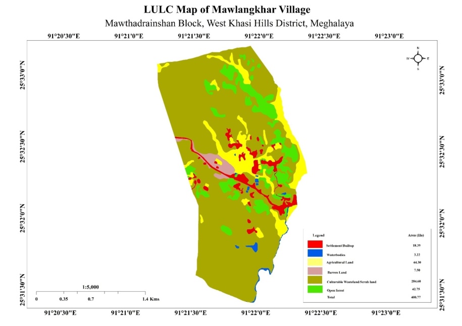
Land Use Land Cover Pattern:
6.
Land Use Land Cover Pattern:
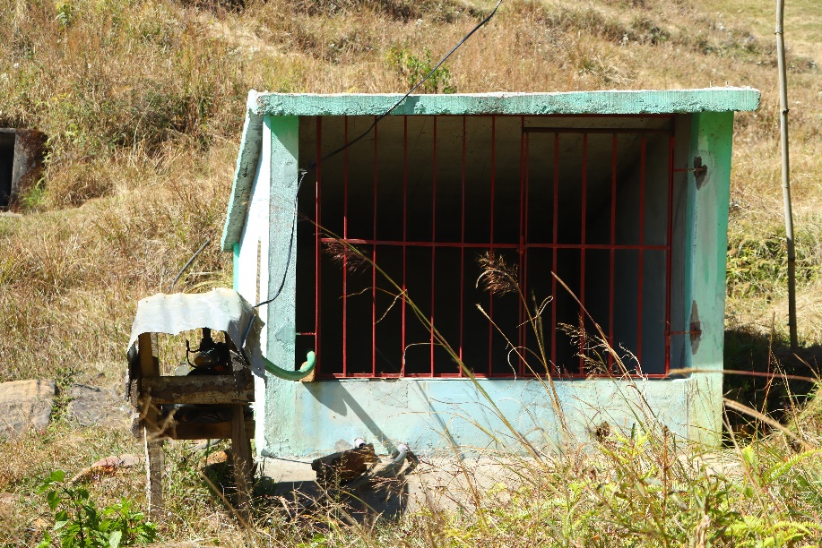
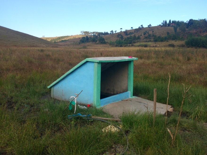
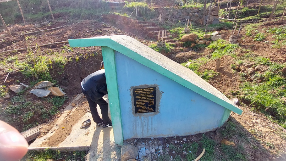
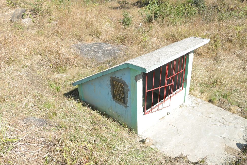
Springs- 6 (5 CLLMP).
Private fish ponds-7.
Forest- 42.75 Ha.
1. Ground Truthing:
On 2nd July, 2019, the District Project Management Unit (DPMU) and other CLLMP officials visited Mawlangkhar village for ground truthing under the presence of Shri. Pynshngain L. Marshillong, the Headman of Mawlangkhar village and other representatives for field assessment. The Headman provided the team with important information regarding the current scenario of the landscape and the natural resource management under his headmanship.
Case Findings:
The village has 104household, out of which 89 HH falls under BPL and 15 HH falls under APL
Few patches of degraded land
Burning of forest in winter season which leads to the loss of natural vegetation.
Availability of spring which is the source of water supply
Actively performing VEC
2. Sensitization Programme:
The District Project Manager and Assistant Managers held a village Sensitization program on the Community Led Landscape Management Project on the 6th August, 2019. A total of 70 villagers participated in the program, voicing out their concerns and questions regarding the project making it a huge success.
Highlight of the Meeting:
Awareness about community – Landscape Management Project
Laying importance on the involvement of the community in making the CNRM plan and its success
A brief awareness on cleanliness was conducted based on our findings during ground truthing phase
An interactive session was held to answer the doubts of the villagers regarding the project
2.1. Signing of EOI, VGA and Green Charter:
Mawlangkhar village signed the Expression of interest (EOI), the Village Grant Agreement (VGA) and the Green Charter after there was a uniform agreement by the entire community that the Community Led Landscape Management Project (CLLMP) be implemented at Mawlangkhar village.
2.2. Formation of VNMRC:
The formation of the Village Natural Resource Management Committee was done on the 14th June, 2019, in a public meeting in the presence of the entire village and the CLLMP staffs. The community chose the President, the Secretary, and other executive members of the committee.
List below are the members of VNMRC:
| Village Natural Resource Management Committee (9member committee constituted from Village Council and VEC, SHG group, Women’s group, youth;4 members should be women) | ||||||||
|---|---|---|---|---|---|---|---|---|
| Sl No | Name in Full | Gender M/F | Age (in Yrs) | Education | Designation | Occupation | Community | Contact No. |
| 1 | Pynshngain L.Marshillong | M | 31 | BSc | President | Teacher | Khasi | 6009390858 |
| 2 | Poantimai | F | 46 | IX | Secretary | Farmer | Khasi | - |
| 3 | Youlinda L Marshillong | F | 29 | XII | Member | Farmer | Khasi | 9856197944 |
| 4 | Twiklina.L. Marshillong |
F | 57 | IV | Member | Farmer | Khasi | 9366280523 |
| 5 | Elgina Sohshang |
F | 25 | BA | Member | Farmer | Khasi | 9863069082 |
| 6 | Khrekstar L.Marshillong | M | Member | Farmer | Khasi | |||
| 7 | Shrengly Kharsyntiew |
M | 80 | XI | Member | Farmer | Khasi | 8794363911 |
| 8 | G. Ningstar Marthong |
M | Member | Farmer | Khasi | |||
| 9 | Hastarland Lyngkhoi |
M | 52 | IX | Member | Farmer | Khasi | 9366404239 |
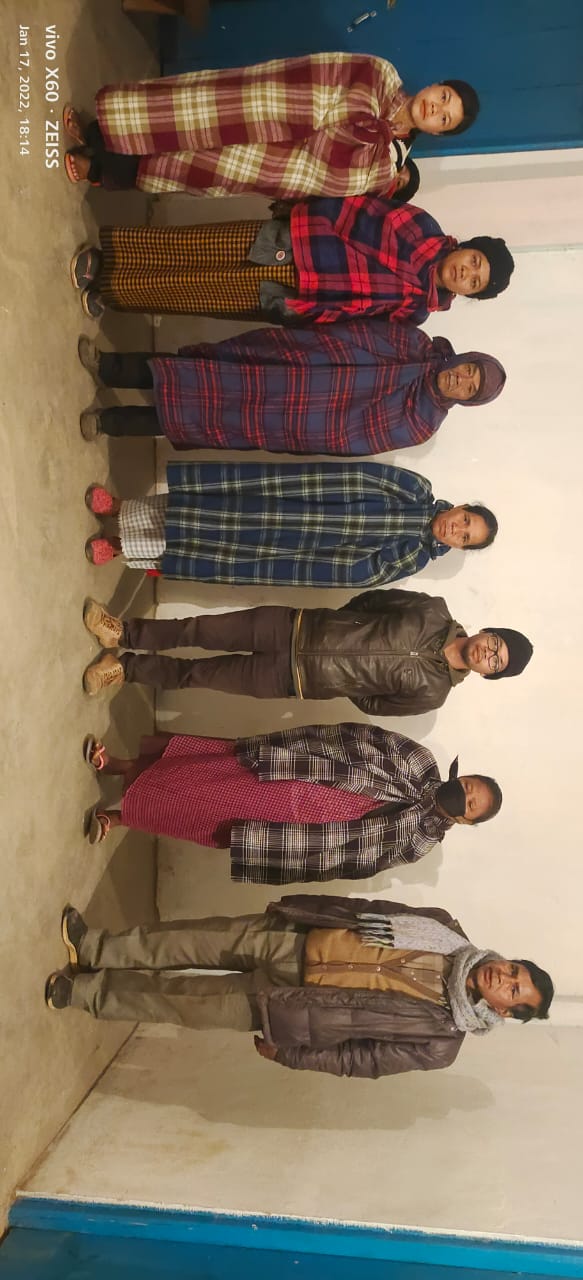
Fig.1. Village Natural Resource Management Committee (VNRMC)
| Village Community Facilitators | ||||||
|---|---|---|---|---|---|---|
| Sl. No | Name | Gender | Age | Education | Contact Number | Role |
| 1 | Robinson Marngar | M | 27 | XII | 7005772885 | VCF Documentation |
| 2 | Mekstarland Marthong | M | 25 | BA | 8787487806 | VCF GIS & Environment |
| 3 | Miartimai S mawdoh | F | 27 | XI | 6009004327 | VCF Social |
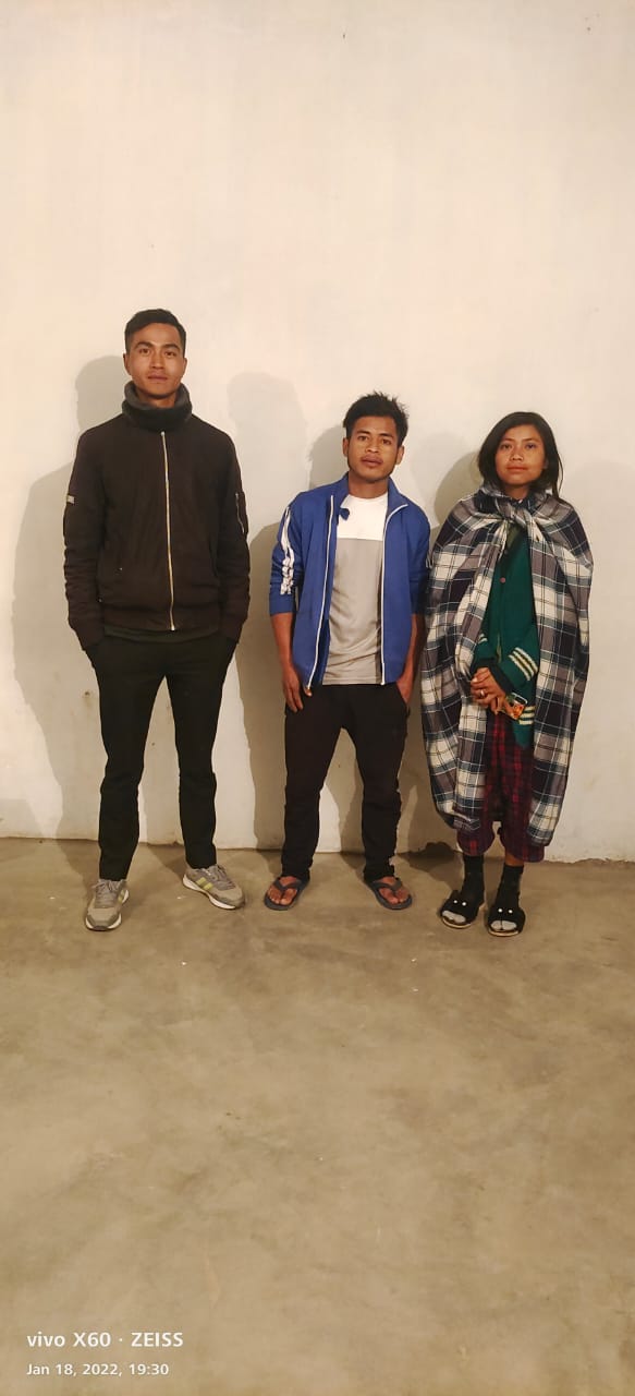
Fig2. Village Community Facilitators (VCFs)
| List of Procurement Members | |||||
|---|---|---|---|---|---|
| Sl. No. | Name | Gender | Age | Education | Contact Number |
| 1. | M. Lyngkhoi | M | 61 | IX | 9612663790 |
| 2. | R. Lyngkhoi | M | 35 | BA | 8787780070 |
| 3. | |||||
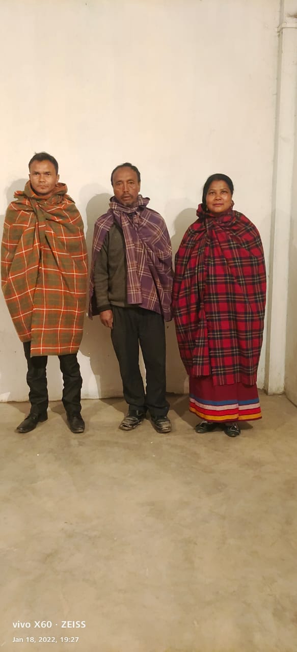
Fig 3. Procurement Committee Members
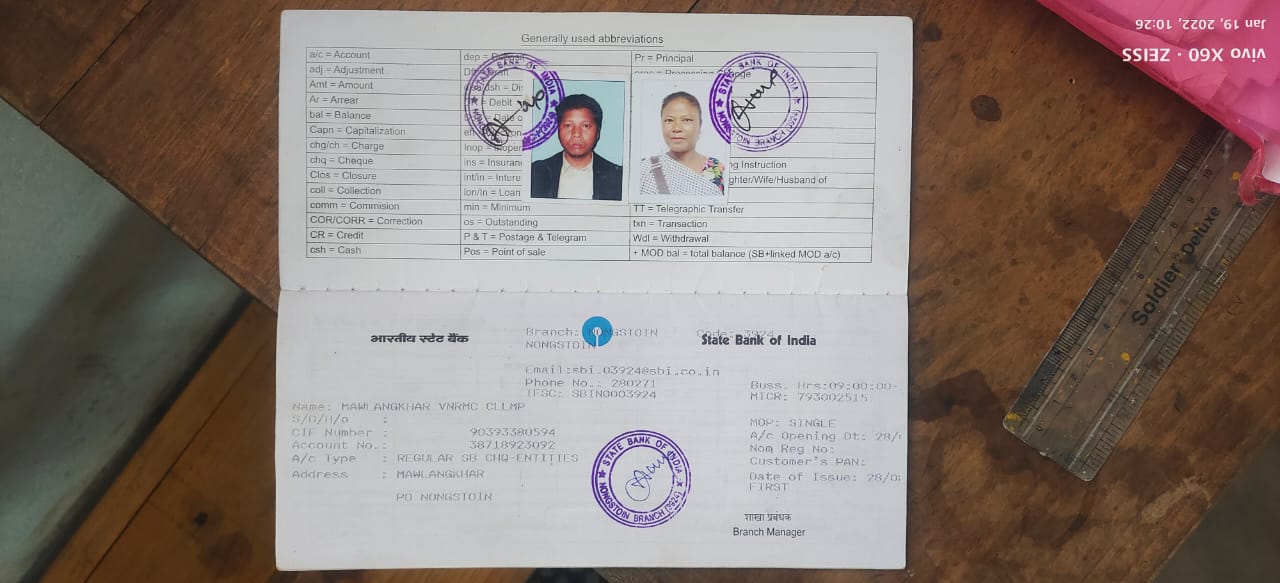
3.Opening of Bank Account:
The opening of bank account was done after the signing of the EOI (Expression of Interest), the Village Grant Agreement (VGA) and the signing of Green Charter at the respective villages.
A meeting was held for all the VNMRC members of Mawlangkhar to brief and assist them before opening the VNMRC bank account. The bank account was opened on 28.8.2019.
4. Participatory Rural Appraisal:
The PRA aims to incorporate the knowledge and opinions of the community in the planning and management of development projects and programs. The PRA exercise at Mawlangkhar village took place on the 20th August, 2019, where a total of 70 villagers both men and women included took part in the exercise.
The initial stage of Participatory Rural Appraisal exercise at Mawlangkhar village commenced with a meeting cum orientation program on CLLMP. While conducting the meeting, the community members were made aware of the various PRA exercise to be conducted for the development of the Community Natural Resource Management Plan (CNRMP) of the village, the community members contribution in the exercise and the objective to be achieved. The key informants being the VNMRC and the VCFs helped facilitate maximum participation.
Commencement of PRA:
Introduction:
Participatory of Rural Appraisal is the process of involving local people in the analysis and interpretation of their own situation of a given rural area. The local people i.e., the participants take a leadership role in collecting, analyzing, interpreting, and presenting information and in this process impart knowledge and development insight to the specialist and extension agents for management of natural resources. Participatory Rural Appraisal is conducted to establish rapport with the village community as well as to identify and define problems for prioritization in the village itself. It is a way of learning from and with community members to investigate their need assessment, analyze and evaluate constraints and opportunities and find out priorities in the area of agriculture, small scale rural enterprises and any other social and economic development programs addressed to village development based on the principle of listening and learning.
Objectives of PRA exercise at Mawlangkhar Village:
The Participatory Rural Appraisal exercise at Mawlangkhar was conducted with following objectives:
To identify the natural human and economic resources of village
To identify the village problems and prioritize them with the help of community members.
To prepare the community natural resource Management Plan of the village.
Activity 4.1: Village Boundary Mapping and Drawing the Resource Map:
The GIS personnel along with Village Community Facilitators mapped the village boundary of Mawlangkhar village.
The second step is to involve the local community in preparation of village resource map as perceived by the community members to solicit their participation, infrastructure, services, and other village resources such as agricultural land, well, wasteland, cattle population etc. were mapped. Local people prepared the resource map by drawing it on a chart paper without much interference of outsiders.
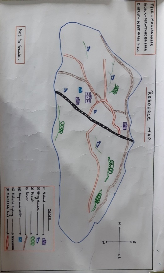
The activity achieved the following purposes:
Rapport building and won the confidence of the villagers.
Analyzed the spatial information particularly studied problems and opportunities of villagers.
Got an impression about the village setting physical layout location of various houses and institutions.
Findings Based on the Resource Map of Mawlangkhar village:
Main agriculture produce is squash, potato, paddy, maize, mustard leaf.
Private forest.
Presence of barren land.
Presence of community hall.
School: one LP one UP and one secondary school.
Two rivers Wah Tyrut and Um Pdengshnong are present and flow through village paddy field.
Presence of Integrated Child Development Services (ICDS).
There are two churches in the village.
Habitation is not confined to one place but spread all over the village.
Activity 4.2: Baseline Data Survey to fill the Environment and Social Template:
During the PRA exercise, the External Experts of Social & Environment Management held a group discussion with different groups to gather basic village information regarding number of households, demographic information, major crops, and enterprises taken in the village trends of production and productivity of major crops in the village and demographic distribution of village population.
Information related to land use category such as forest, cultivable land, water bodies, etc and problems and challenges related to NRM were discussed.
Activity 4.3: Focused Group Discussion on Problem Analysis:
Do people have sufficient access to supply of fodder, fuel wood, leaf litter?
No people in the village does not have sufficient access to fodder, fuel wood and leaf litter.
Has access to timber has reduced over the years? How is access for household use and commercial use managed?
Access to timber has reduced over the years. People in the village get it from private land which is not enough.
Are the water bodies facing any threats?
Yes.
Do all people in the village have access to drinking water? What are the challenges?
No, there is insufficient availability of drinking water, due to inadequate of drinking water supply and lack of water resources.
Are there degraded areas in the village (open/ degraded forests, mining affected, high soil erosion etc.)?
Yes, there are some degraded areas in cultivable and forest land.
What has caused this degradation? Are there practices causing threats to availability and access to natural resources?
Burning of forest in winter season and deforestation.
Fertility of the soil decline over the year.
What have been the changes in agricultural practices?
Over the years people in the village practiced traditional way of farming, but later people are using chemical fertilizers in order to increase agricultural production.
Are there any challenges in farming?
Yes, lack of water supply.
How would you consider the health situation in your village?
The nearest PHC is at the distance of 6 kms which is easily available for the community in the village.
How is the situation of cleanliness, sanitation, access to toilets and waste management?
Sufficient toilets are available in every household but the level of awareness on waste management is not satisfactory.
Who are the most vulnerable in the village? What can be done to improve their lives?
BPL families.
What are the livelihood aspirations of the youth? Are there any avenues available?
Employment.
Do any committees/ Institutions/ rules exist to manage and monitor natural resource in the village?
Village Executive of the village Dorbar.
What are some of the major issues of conflict in the village?
Land and water dispute.
Have any of the above issues been discussed in village meetings?
Yes.
How do people resolve disagreement and conflicts
All disagreements and conflicts are addressed by the traditional institution of village called the village Dorbar.
Activity 4.4: Seasonal Calendar:
The CLLMP team also mapped the seasonal calendar of Mawlangkhar village to help identify heavy workload periods, periods of relative ease, credit crunch, diseases, food security, wage availability etc. This will prove helpful in project planning and project timeline framing.
| Seasonal Calendar | |||||||||||||
|---|---|---|---|---|---|---|---|---|---|---|---|---|---|
| Sl. No. | Criteria | Jan | Feb | Mar | Apr | Mar | Jun | Jul | Aug | Sep | Oct | Nov | Dec |
| 1 | Water scarcity | 1 | 1 | 3 | 2 | ||||||||
| 2 | Prone to sickness | 2 | 1 | 1 | 2 | ||||||||
| 3 | Seeking job outside | 1 | 2 | 1 | |||||||||
| 4 | Rainfall | 1 | 1 | 2 | |||||||||
| 5 | Free less work | ||||||||||||
| 6 | Paddy cultivation | 1 | 1 | ||||||||||
| 7 | Paddy harvesting | 1 | 1 | ||||||||||
| 8 | Tree plantation | 1 | 1 | ||||||||||
| 9 | Vegetable crop Plantation | 1 | 1 | 2 | 2 | ||||||||
| 10 | Vegetable crop harvesting | 3 | 2 | 1 | 2 | 1 | |||||||
| 11 | Festive | 1 | 2 | 2 | 1 | ||||||||
| 12 | Forest fire | ||||||||||||
| 13 | Collection of fuel wood | 1 | 3 | 2 | 1 | 1 | |||||||
| Maximum | 1 | ||||||||||||
| Medium | 2 | ||||||||||||
| Low | 3 | ||||||||||||
 5. Submission of
CNRMP:
5. Submission of
CNRMP:
5.1: The Final Community Natural Resource Management Plan:
Sl. No. |
Name of Proposed Intervention | Site | Land ownership | No of HHs expected to benefit | Priority(high/Medium/Low) | ||
|---|---|---|---|---|---|---|---|
| BPL | APL | Total | |||||
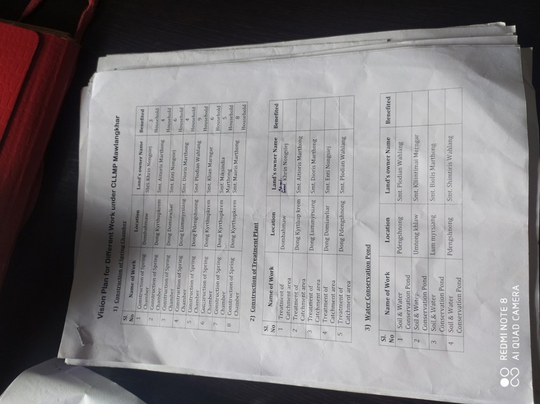
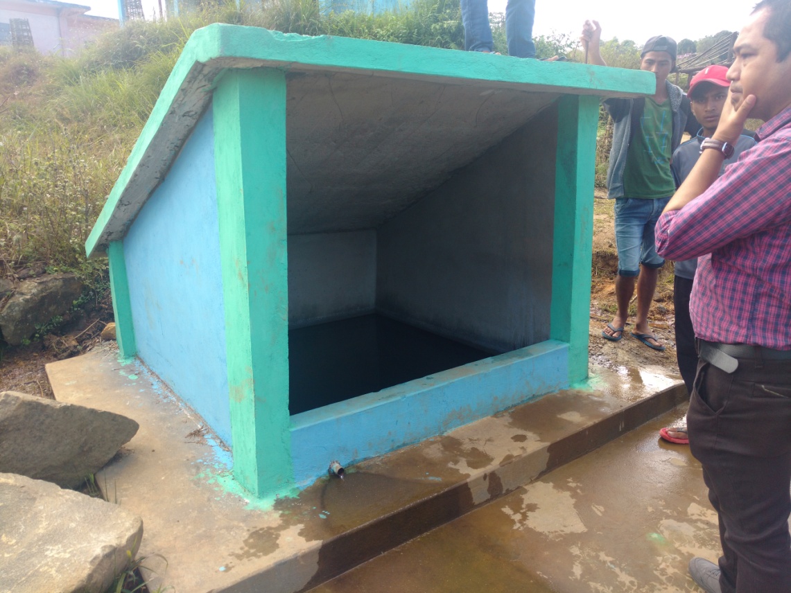
| 1 | Spring Chamber | Dombahmaw | Private | 2 | 2 | 4 | High |
| 2 | Spring Chamber | Dong Kyrthupkrem | Private | 4 | 4 | 8 | High |
| 3 | Spring Chamber | Domiawlar | Private | 6 | 5 | 11 | High |
| 4 | Spring Chamber | Lummyrsiang | Private | 5 | 5 | 10 | High |
| 5 | Spring Chamber | Pdengshnong | Private | 3 | 2 | 5 | High |
| 6 | Treatment of Catchment Area | Dombahmaw | Private | 2 | 2 | 4 | High |
| 7 | Treatment of Catchment Area | Kyrthupkrem | Private | 4 | 4 | 8 | High |
| 8 | Treatment of Catchment Area | Lummyrsiang | Private | 5 | 5 | 10 | High |
| 9 | Treatment of Catchment Area | Domiawliar | Private | 5 | 5 | 10 | High |
| 10 | Treatment of Catchment Area | Pdengshnong | Private | 3 | 2 | 5 | High |
| 11 | Soil and Water Conservation Pond | Pdengshnong | Private | High | |||
| 12 | Soil and Water Conservation Pond | Umtongkhlaw | Private | High | |||
| 13 | Soil and Water Conservation Pond | Lum myrsiang | Private | High | |||
| 14 | Soil and Water Conservation Pond | Pdengshnong | Private | High | |||
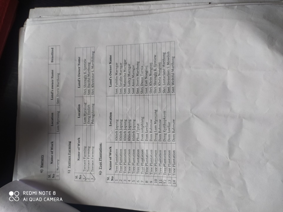
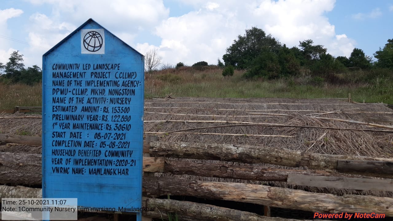
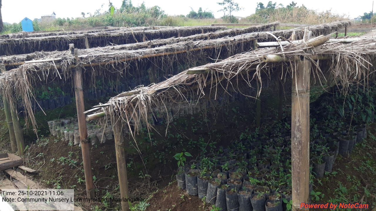
| 15 | Nursery | Lummyrsiang | Private | High | |||
| 16 | Terrace Farming | Lummyrsiang | Private | High | |||
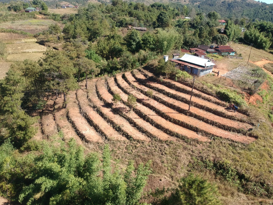
| 17 | Terrace Farming | Dongumlieh | Private | High | |||
| 18 | Terrace Farming | Pdengshnong | Private | High | |||
| 19 | Tree Plantation | Khlieh Japung | Private | High | |||
| 20 | Tree Plantation | Phud Tyrut | Private | High | |||
| 21 | Tree Plantation | Domsohphlang | Private | High | |||
| 22 | Tree Plantation | Domiawliar | Private | High | |||
| 23 | Tree Plantation | Dombahmaw | Private | High | |||
| 24 | Tree Plantation | Lum Myrsiang | Private | High | |||
| 25 | Tree Plantation | Kyrthupkrem | Private | High | |||
6. GIS Activities:
| Sl. No. | Parameters | Village information |
|---|---|---|
| GPS coordinates | ||
| i. | Latitude | 25.537354° |
| ii. | Longitude | 91.366310° |
| iii. | Elevation reading (MSL) | 1609 m |
| Village Geographical area (Ha) | Total 400.77 ha 4.0077 sq km | |
| i. | Total Forest Area (including community, clan, Pvt. Forest) | 42.75 ha |
| ii. | Total area of water Bodies | 3.22 ha |
| iii. | Total area under Agri- horticulture | No agriculture-horticulture area |
| iv. | Total degraded land area (ha) | 7.78 |
| Average annual rainfall | 1200 -3000 mm | |
| Soil type | Fine loamy soils | |
7. Project implementation:
| 1 | Type of Intervention | Site Name | GPS- Coordinates | Amount Sanctioned | Work status | |
|---|---|---|---|---|---|---|
| Spring chamber | Pdengshnong | 25.537885 | 91.366512 | 42,300 | Completed | |
| Treatment of Catchment Area | 3500 | |||||
| 2 | Type of Intervention | Site Name | GPS- Coordinates | Amount Sanctioned | Work status | |
|---|---|---|---|---|---|---|
| Spring chamber | Domiawliar | 25.53375 | 91.366003 | 42,300 | Completed | |
| Treatment of catchment area | 3500 | |||||
| 3 | Type of Intervention | Site Name | GPS- Coordinates | Amount Sanctioned | Work status | |
|---|---|---|---|---|---|---|
| Spring chamber | Dombahmaw | 25.540508 | 91.361967 | 42,300 | Completed | |
| Treatment of catchment area | 3500 | |||||
| 4 | Type of Intervention | Site Name | GPS- Coordinates | Amount Sanctioned | Work status | |
|---|---|---|---|---|---|---|
| Spring chamber | kyrthupkrem | 25.539062 | 91.353085 | 42,300 | Completed | |
| Treatment of catchment area | 3500 | |||||
| 5 | Type of Intervention | Site Name | GPS- Coordinates | Amount Sanctioned | Work status | |
|---|---|---|---|---|---|---|
| Spring chamber | Lummyrsiang | 25.543458 | 91.36744 | 42,300 | Completed | |
| Treatment of catchment area | 3500 | |||||
| 6 | Type of Intervention | Site Name | GPS- Coordinates | Amount Sanctioned | Work status | |
|---|---|---|---|---|---|---|
| Terrace farming | Pdengshnong | 253224.857”N | 9122’02.537”E | 75300 | Completed | |
| 7 | Type of Intervention | Site Name | GPS- Coordinates | Amount Sanctioned | Work status | |
|---|---|---|---|---|---|---|
| Nursery | Lummyrsiang | 25.541957 | 91.36682 | 15,3500 | Completed | |
| 8 | Type of Intervention | Site Name | GPS- Coordinates | Amount Sanctioned | Work status | |
|---|---|---|---|---|---|---|
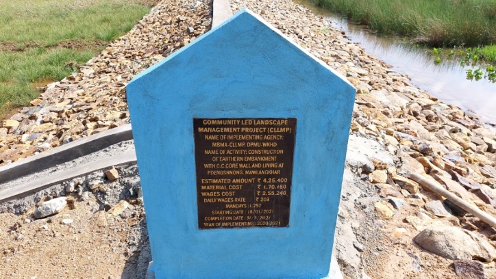
| Earthen Embankment with CC core Wall | Pdengshnong | 25.540295 | 425400 | Completed | ||

8. Fund status:
| Fund released to VNRMC (Project Implementation) | Total No. of Work Order Issued | Total amount issued under CLLMP (per Activity) | Total Amount Spent | Start Date | End Date |
|---|---|---|---|---|---|
| ₹20,66,248.00 | 19 | Community Nursery | 1,11,878 | 08-Jul-21 | 05-Aug-21 |
| Spring Chamber | 38,237 | 29-Jun-20 | 10-Aug-20 | ||
| Treatment of Catchment Area | 3,500 | 03-Jul-20 | 03-Jul-20 | ||
| Spring Chamber | 38,237 | 29-Jun-20 | 17-Aug-20 | ||
| Treatment of Catchment Area | 3,500 | 03-Jul-20 | 03-Jul-20 | ||
| Spring Chamber | 38,238 | 29-Jun-20 | 07-Aug-20 | ||
| Treatment of Catchment Area | 3,500 | 27-Jul-20 | 27-Jul-20 | ||
| Spring Chamber | 38,238 | 29-Jun-20 | 24-Aug-20 | ||
| Treatment of Catchment Area | 3,500 | 03-Jul-20 | 03-Jul-20 | ||
| Spring Chamber | 38,238 | 29-Jun-20 | 08-Aug-20 | ||
| Treatment of Catchment Area | 3,500 | 27-Jul-20 | 27-Jul-20 | ||
| Afforestation | 1,04,272 | 01-Jun-22 | 22-Jul-22 | ||
| Sataggered tenches | 4,608 | 01-Jun-22 | 22-Jul-22 | ||
| Terrace Farming | 65,493 | 30-Aug-21 | 26-Oct-21 | ||
| Earthen Embankment with CC core wall and lining | 4,97,677 | 18-Jan-21 | 31-Mar-21 | ||
| CC Check Dam | 6,31,707 | 07-Mar-22 | 18-Jul-22 | ||
| Water Conservation Pond | 2,83,900 | 11-Aug-22 | 19-Sep-22 | ||
| Staggered Trenches | 6,912 | 01-Aug-22 | 05-Sep-22 | ||
| Agro- Horticulture with Staggered Trenches | 1,53,488 | 01-Aug-22 | 05-Sep-22 | ||
| Water Conservation Pond | 4,32,500 | 18-Apr-23 | 12-Jun-23 | ||
| Total Amount Spent | 2501123 | ||||